

List of islands of California
Encyclopedia
This is a list of islands of California
. The Geographic Names Information System
(GNIS) lists 527 named islands in the state.
are a group of eight main islands and several minor islands in the Pacific Ocean
off the coast of Santa Barbara-
, Los Angeles-, and Ventura-counties in Southern California
. The four northern islands are protected in Channel Islands National Park
, while two are used by the U.S. Navy.
are a group of rugged small islands over 20 miles (32.2 km) offshore from the city of San Francisco. They consist of over twenty small islets divided into north, south and middle sections, as well as a major bank
, Fanny Shoal. The surrounding waters were once used as a disposal site for radioactive waste
.
Greater Los Angeles Area
Humboldt Bay
and the city of Newport Beach, California
.
San Francisco Bay Area
Other islands of the Bay Area:
Suisun Bay
California
California is a state located on the West Coast of the United States. It is by far the most populous U.S. state, and the third-largest by land area...
. The Geographic Names Information System
Geographic Names Information System
The Geographic Names Information System is a database that contains name and locative information about more than two million physical and cultural features located throughout the United States of America and its territories. It is a type of gazetteer...
(GNIS) lists 527 named islands in the state.
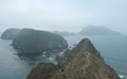
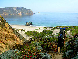
Channel Islands
The Channel IslandsChannel Islands of California
The Channel Islands of California are a chain of eight islands located in the Pacific Ocean off the coast of Southern California along the Santa Barbara Channel in the United States of America...
are a group of eight main islands and several minor islands in the Pacific Ocean
Pacific Ocean
The Pacific Ocean is the largest of the Earth's oceanic divisions. It extends from the Arctic in the north to the Southern Ocean in the south, bounded by Asia and Australia in the west, and the Americas in the east.At 165.2 million square kilometres in area, this largest division of the World...
off the coast of Santa Barbara-
Santa Barbara County, California
Santa Barbara County is a county located in the southern portion of the U.S. state of California, on the Pacific coast. As of 2010 the county had a population of 423,895. The county seat is Santa Barbara and the largest city is Santa Maria.-History:...
, Los Angeles-, and Ventura-counties in Southern California
Southern California
Southern California is a megaregion, or megapolitan area, in the southern area of the U.S. state of California. Large urban areas include Greater Los Angeles and Greater San Diego. The urban area stretches along the coast from Ventura through the Southland and Inland Empire to San Diego...
. The four northern islands are protected in Channel Islands National Park
Channel Islands National Park
- External links :* Official site: * *...
, while two are used by the U.S. Navy.
| Island | Image | Coordinates | Description |
|---|---|---|---|
| Anacapa Island Anacapa Island Anacapa Island is a small volcanic island located about off the coast of Port Hueneme, California, in Ventura County. The Island is composed of a series of narrow islets six miles long, running in a mostly east-west orientation, five miles east of Santa Cruz Island... |
 |
34.0044486°N 119.3995603°W | Located 14 miles (22.5 km) off the coast of Ventura, California Ventura, California Ventura is the county seat of Ventura County, California, United States, incorporated in 1866. The population was 106,433 at the 2010 census, up from 100,916 at the 2000 census. Ventura is accessible via U.S... . It contains 728 acres (294.6 ha) of land spread across three mountainous islets. The island has only three permanent residents. |
| Begg Rock Begg Rock Begg Rock, high, is northwest of the west point of San Nicolas Island, Ventura County California. This island rises abruptly from depths of . A reef extends north and south of the island over in each direction. A lighted whistle buoy is north of the rock. This rock may be found on NOAA chart... |
33°21′45"N 119°41′52"W | A 15 feet (4.6 m) high rock, located 8 miles (12.9 km) from San Nicolas Island. | |
| Prince Island | 34°03′29"N 120°20′01"W | Located near San Miguel Island San Miguel Island San Miguel Island is the westernmost of California's Channel Islands, located across the Santa Barbara Channel in the Pacific Ocean, within Santa Barbara County, California. San Miguel is the sixth-largest of the eight Channel Islands at , including offshore islands and rocks. Prince Island, off... and measures about 35 acres (14.2 ha). |
|
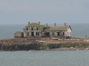
| San Clemente Island San Clemente Island San Clemente Island is the southernmost of the Channel Islands of California. It is owned and operated by the United States Navy, and is a part of Los Angeles County. Defined by the United States Census Bureau as Block Group 2 of Census Tract 5991 of Los Angeles County, California, it is long and... |
 |
32.9000357°N 118.5009115°W | Southernmost Channel Island, containing 56.81 mi2 of land. It is 24 miles (38.6 km) long, and uninhabited. An active U.S. Navy base is located on the island. |
| San Miguel Island San Miguel Island San Miguel Island is the westernmost of California's Channel Islands, located across the Santa Barbara Channel in the Pacific Ocean, within Santa Barbara County, California. San Miguel is the sixth-largest of the eight Channel Islands at , including offshore islands and rocks. Prince Island, off... |
 |
34.0397186°N 120.3754264°W | Westernmost Channel Island, measuring 8 miles (12.9 km) long, 3.7 miles (6 km) wide, and containing 9325 acres (3,773.7 ha) of land. The island is uninhabited, and is rarely visited. |
| San Nicolas Island San Nicolas Island San Nicolas Island is the most remote of California's Channel Islands. It is part of Ventura County. The 14,562 acre island is currently controlled by the United States Navy and is used as a weapons testing and training facility, served by Naval Outlying Field San Nicolas Island... |
33.2494750°N 119.5003847°W | Is said to be the most remote island of the Channel Islands, and is used by the U.S. Navy as a weapons testing and training facility. It has no civilian inhabitants, but is inhabited by military personnel. It covers 14562 acres (5,893 ha). | |
| Santa Barbara Island Santa Barbara Island Santa Barbara Island is a small island of the Channel Islands archipelago in California. It is located about off the Southern California coast from the Palos Verdes Peninsula, near Los Angeles in Ventura County, California.... |
 |
33.4755796°N 119.0362111°W | Smallest Channel Island at 640 acres (259 ha) in area; it is located roughly between San Nicolas and Santa Catalina Island Santa Catalina Island, California Santa Catalina Island, often called Catalina Island, or just Catalina, is a rocky island off the coast of the U.S. state of California. The island is long and across at its greatest width. The island is located about south-southwest of Los Angeles, California. The highest point on the island is... s. |
| Santa Catalina Island Santa Catalina Island, California Santa Catalina Island, often called Catalina Island, or just Catalina, is a rocky island off the coast of the U.S. state of California. The island is long and across at its greatest width. The island is located about south-southwest of Los Angeles, California. The highest point on the island is... |
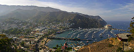 |
33.3833613°N 118.4175764°W | The most inhabited of the Channel Islands, with a population of 3,696 as of 2000. It is about 22 miles (35.4 km) long with a maximum width of 8 miles (12.9 km). It covers 74.98 mi2. |
| Santa Cruz Island Santa Cruz Island Santa Cruz Island was the largest privately owned island off the continental United States, but is currently part-owned by the National Park service . The island, located off the coast of California, is long and from wide... |
 |
34.0402815°N 119.8437411°W | Santa Cruz Island measures 22 miles (35.4 km) long with an average width of 4 miles (6.4 km), covering 96.5 mi2. It is the largest Channel Island. The island is now on public land, but was previously the largest privately owned island of the continental United States. |
| Santa Rosa Island Santa Rosa Island, California Santa Rosa Island is the second largest of the Channel Islands of California at 53,195 acres . Defined by the United States Census Bureau as Block 3009, Block Group 3, Census Tract 29.10 of Santa Barbara County, California, the 2000 census showed an official population of 2 persons. It is part of... |
 |
33.9500030°N 120.1009639°W | Santa Rosa Island occupies 83.1 mi2, and is the second largest Channel Island. The island has a permanent population of 2 persons, and is about 26 miles (41.8 km) off the coast of Santa Barbara, California Santa Barbara, California Santa Barbara is the county seat of Santa Barbara County, California, United States. Situated on an east-west trending section of coastline, the longest such section on the West Coast of the United States, the city lies between the steeply-rising Santa Ynez Mountains and the Pacific Ocean... . |
| Shag Rock | 33.4869680°N 119.0362112°W | Small islet located off the north shore of Santa Barbara Island, and is only about 1 acre (0.404686 ha). | |
| Sutil Island | 33.4639132°N 119.0481557°W | Located off the southwest shore of Santa Barbara Island, and is about 12 acres (4.9 ha). It is named for a Spanish Spain Spain , officially the Kingdom of Spain languages]] under the European Charter for Regional or Minority Languages. In each of these, Spain's official name is as follows:;;;;;;), is a country and member state of the European Union located in southwestern Europe on the Iberian Peninsula... ship exploring the West Coast in an expedition led by Sebastián Vizcaíno Sebastián Vizcaíno Sebastián Vizcaíno was a Spanish soldier, entrepreneur, explorer, and diplomat whose varied roles took him to New Spain, the Philippines, the Baja California peninsula, the California coast and Japan.-Early career:... . |
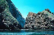
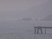
Farallon Islands
The Farallon IslandsFarallon Islands
The Farallon Islands, or Farallones , are a group of islands and sea stacks in the Gulf of the Farallones, off the coast of San Francisco, California, USA. They lie outside the Golden Gate and south of Point Reyes, and are visible from the mainland on clear days...
are a group of rugged small islands over 20 miles (32.2 km) offshore from the city of San Francisco. They consist of over twenty small islets divided into north, south and middle sections, as well as a major bank
Bank (topography)
A bank, sometimes referred to as a fishing bank, is an area on the continental shelf which is shallow compared to its surrounding area, such as a shoal or the top of an underwater hill. Somewhat like continental slopes, ocean banks slopes can upwell as tidal and other flows intercept them,...
, Fanny Shoal. The surrounding waters were once used as a disposal site for radioactive waste
Radioactive waste
Radioactive wastes are wastes that contain radioactive material. Radioactive wastes are usually by-products of nuclear power generation and other applications of nuclear fission or nuclear technology, such as research and medicine...
.
| Island | Image | Coordinates | Description |
|---|---|---|---|
| Southeast Farallon Island |  |
37.6971532°N 123.0030547°W | Is the largest of the Farallons, covering 0.19 mi2. It is the only inhabited Farallon Island, and is also the site of Farallon Island Light Farallon Island Light Farallon Island Light is a lighthouse on Southeast Farallon Island, California. One of the highest lights in California, it was constructed in 1855 to warn ships approaching San Francisco from the... . |
| Seal Rock | 37.69382°N 123.0033325°W | Small islet south of Southeast Farallon Island, with a maximum height of 82 feet (25 m). | |
| Maintop Island | 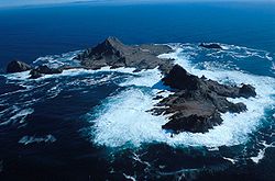 |
37.6990977°N 123.0111106°W | West of Southeast Farallon Island, and has a maximum height of 223 feet (68 m). |
| Drunk Uncle Islets | Group of small islets north of Maintop Island. | ||
| Aulone Island and Great Arch Rock | 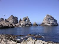 |
37.70234°N 123.00417°W | North of Southeast Farallon Island, measuring 200 feet (61 m) wide and 400 feet (121.9 m) long. |
| Sugarloaf Island | 37.70353°N 123.00321°W | Directly to the northeast of Aulone and Great Arch Rock, about 80 feet (24.4 m) high. | |
| Sea Lion Rock Sea Lion Rock Sea Lion Rock is a rock of the Commander Islands near the Kamchatka Peninsula, Russia.Some private individuals in the United States claim that this island, along with Medny Island and Sea Otter Rocks, are disputed territory based on the Alaskan Purchase . However, the U.S. government has never... |
37.70291°N 123.00542°W | Small islet northwest of Aulon Island, about 130 feet (39.6 m) long. | |
| Middle Farallon Island | 37.7271525°N 123.0322224°W | Medium-sized islet 1.8 miles (2.9 km) northwest of Southeast Farallon Island. It is 210 feet (64 m) long and has an area of 0.8 acre (0.3237488 ha). | |
| North Farallon Island | 37.7621521°N 123.0980578°W | Medium-sized islet 500 feet (152.4 m) long and 100 feet (30.5 m) high, covering 2 acre (0.809372 ha). | |
| Island of St. James | 37.7665966°N 123.1013912°W | Medium-sized islet 3 acres (1.2 ha) in size, measuring 410 feet (125 m) long and 154 feet (46.9 m) high. | |
| Piedra Guadalupe | |||
| Peñasco Quebrado | |||
| Farallón Viscaíno |
Lake islands
| Island | Image | Coordinates | Lake | Description |
|---|---|---|---|---|
| Fannette Island Fannette Island Fannette Island is the only island in Lake Tahoe, California/Nevada, United States. It lies within Emerald Bay. Over a long period of time, it was called many different names, including Coquette, Fanette, Baranoff, Dead Man's, Hermit's, and Emerald Isle. The island contains what is left of "Tea... |
 |
38.9540745°N 120.1004631°W | Lake Tahoe Lake Tahoe Lake Tahoe is a large freshwater lake in the Sierra Nevada of the United States. At a surface elevation of , it is located along the border between California and Nevada, west of Carson City. Lake Tahoe is the largest alpine lake in North America. Its depth is , making it the USA's second-deepest... |
The only major island in Lake Tahoe, located within Emerald Bay. |
| Main Island |  |
34.3947182°N 119.3428929°W | Lake Casitas Lake Casitas Lake Casitas is an artificial lake in the Los Padres National Forest of Ventura County, California, created by the construction of Casitas Dam on Coyote Creek, two miles before it joins the Ventura River. Santa Ana Creek and North Fork Coyote Creek also flow into the lake. The dam was constructed... |
A 1.5 miles (2.4 km) long, 850 feet (259.1 m) high island rising 512 feet (156.1 m) above the lake surface. |
| Mullet Island | Salton Sea Salton Sea The Salton Sea is a shallow, saline, endorheic rift lake located directly on the San Andreas Fault, predominantly in California's Imperial Valley. The lake occupies the lowest elevations of the Salton Sink in the Colorado Desert of Imperial and Riverside counties in Southern California. Like Death... |
A small volcanic island near the southern end of the Salton Sea near the mouth of the Alamo River Alamo River The Alamo River is a river flowing west and north from the Mexicali Valley across the Imperial Valley . The river drains into the Salton Sea.... |
||
| Negit Island Negit Island Negit Island is an island in Mono Lake. Negit is a volcanic cone less than 2000 years old. It can be considered to be the northernmost of the Mono Craters. Negit is composed of three dark dacite lava flows.... |
 |
38.0227016°N 119.0495910°W | Mono Lake Mono Lake Mono Lake is a large, shallow saline lake in Mono County, California, formed at least 760,000 years ago as a terminal lake in a basin that has no outlet to the ocean... |
A young volcanic cone Volcanic cone Volcanic cones are among the simplest volcanic formations. They are built by ejecta from a volcanic vent, piling up around the vent in the shape of a cone with a central crater. Volcanic cones are of different types, depending upon the nature and size of the fragments ejected during the eruption... , connected to the mainland during low water. It is an important stop for nesting birds, and as a result is closed to visitation during April. |
| Paoha Island Paoha Island Paoha Island is a volcanic island in Mono Lake, an endorheic lake in the U.S. state of California. Formed by a series of eruptions in the 17th century, Paoha is composed of lakebed sediments deposited above volcanic domes. It is one of two major islands in the lake, the other being the smaller... |
 |
38.0004801°N 119.0323683°W | Mono Lake Mono Lake Mono Lake is a large, shallow saline lake in Mono County, California, formed at least 760,000 years ago as a terminal lake in a basin that has no outlet to the ocean... |
2.5 miles (4 km) long and 2 miles (3.2 km) wide, and is the largest Mono Lake island. |
| Rattlesnake Island Rattlesnake Island (Clear Lake) Rattlesnake Island is an island located on Clear Lake in Lake County, northern California. Its land area is nominally , but may vary significantly as lake levels rise and fall... |
39.0098958°N 122.6788750°W | Clear Lake | A 53 acres (21.4 ha) island desired by the Elem Indian Colony Elem Indian Colony The Elem Indian Colony of Pomo Indians are a Native American band of Pomo based on near Clearlake Oaks, California on the Eastern shore of Clear Lake... . |
|
| Red Island | Salton Sea Salton Sea The Salton Sea is a shallow, saline, endorheic rift lake located directly on the San Andreas Fault, predominantly in California's Imperial Valley. The lake occupies the lowest elevations of the Salton Sink in the Colorado Desert of Imperial and Riverside counties in Southern California. Like Death... |
A volcanic island near the southern end of the sea, on the San Andreas Fault San Andreas Fault The San Andreas Fault is a continental strike-slip fault that runs a length of roughly through California in the United States. The fault's motion is right-lateral strike-slip... . |
Greater Los Angeles AreaGreater Los Angeles AreaThe Greater Los Angeles Area, or the Southland, is a term used for the Combined Statistical Area sprawled over five counties in the southern part of California, namely Los Angeles County, Orange County, San Bernardino County, Riverside County and Ventura County...
| Island | Image | Coordinates | Description |
|---|---|---|---|
| Island Chaffee | 33.7397402°N 118.1389547°W | An artificial island Artificial island An artificial island or man-made island is an island or archipelago that has been constructed by people rather than formed by natural means... /oil platform Oil platform An oil platform, also referred to as an offshore platform or, somewhat incorrectly, oil rig, is a lаrge structure with facilities to drill wells, to extract and process oil and natural gas, and to temporarily store product until it can be brought to shore for refining and marketing... named after astronaut Roger B. Chaffee Roger B. Chaffee Roger Bruce Chaffee was an American aeronautical engineer and a NASA astronaut in the Apollo program. Chaffee died along with fellow astronauts Gus Grissom and Ed White during a pre-launch test for the Apollo 1 mission at Cape Kennedy... who died in the Apollo 1 accident. Located in San Pedro Bay San Pedro Bay (California) San Pedro Bay is an inlet on the Pacific Ocean coast of southern California, United States. It is the site of the Port of Los Angeles and the Port of Long Beach, which together form the fifth-busiest port facility in the world and easily the busiest in the Western Hemisphere... . |
|
| Deadman's Island Deadman's Island (San Pedro) Deadman's Island was one of two islands near San Pedro, Los Angeles, California in the 19th century. The land, sometimes referenced as Dead Man's Island, Isla Del Muerto, and Reservation Point, was dredged away in 1928 as part of a harbor development effort... |
 |
33.7236303°N 118.2659040°W | A former island in Los Angeles Harbor, removed in 1928; sometimes referenced as Isla Del Umberto, and Reservation Point |
| Freeman Island | 33.741364°N 118.162423°W | An artificial island Artificial island An artificial island or man-made island is an island or archipelago that has been constructed by people rather than formed by natural means... /oil platform Oil platform An oil platform, also referred to as an offshore platform or, somewhat incorrectly, oil rig, is a lаrge structure with facilities to drill wells, to extract and process oil and natural gas, and to temporarily store product until it can be brought to shore for refining and marketing... named after astronaut Theodore Freeman Theodore Freeman Theodore Cordy Freeman was a NASA astronaut and a captain in the United States Air Force. He was killed in the crash of a T-38 jet, marking the first fatality among the American astronaut corps... who died in a crash. Located in San Pedro Bay San Pedro Bay (California) San Pedro Bay is an inlet on the Pacific Ocean coast of southern California, United States. It is the site of the Port of Los Angeles and the Port of Long Beach, which together form the fifth-busiest port facility in the world and easily the busiest in the Western Hemisphere... . |
|
| Naples Islands | A neighborhood in Long Beach Long Beach, California Long Beach is a city situated in Los Angeles County in Southern California, on the Pacific coast of the United States. The city is the 36th-largest city in the nation and the seventh-largest in California. As of 2010, its population was 462,257... that consists of three different islands divided by canals which empty out into Alamitos Bay Alamitos Bay Alamitos Bay is an inlet on the Pacific Ocean coast of southern California, United States, between the cities of Long Beach and Seal Beach, at the outlet of the San Gabriel River.The bay is named for the Spanish word for 'little poplars'.-Geography:... . |
||
| Island Grissom | 33.7591846°N 118.1814566°W | An artificial island Artificial island An artificial island or man-made island is an island or archipelago that has been constructed by people rather than formed by natural means... /oil platform Oil platform An oil platform, also referred to as an offshore platform or, somewhat incorrectly, oil rig, is a lаrge structure with facilities to drill wells, to extract and process oil and natural gas, and to temporarily store product until it can be brought to shore for refining and marketing... named after astronaut Gus Grissom Gus Grissom Virgil Ivan Grissom , , better known as Gus Grissom, was one of the original NASA Project Mercury astronauts and a United States Air Force pilot... who died in the Apollo 1 accident. Located in San Pedro Bay San Pedro Bay (California) San Pedro Bay is an inlet on the Pacific Ocean coast of southern California, United States. It is the site of the Port of Los Angeles and the Port of Long Beach, which together form the fifth-busiest port facility in the world and easily the busiest in the Western Hemisphere... . |
|
| Terminal Island Terminal Island Terminal Island is an island located in Los Angeles County, California between Los Angeles Harbor and Long Beach Harbor. Originally a mudflat known to the Spanish as Isla Raza de Buena Gente, and later called Rattlesnake Island, it has officially been Terminal Island since 1918... |
 |
33.756963°N 118.248126°W | An artificial island shared between the cities of Los Angeles and Long Beach Long Beach, California Long Beach is a city situated in Los Angeles County in Southern California, on the Pacific coast of the United States. The city is the 36th-largest city in the nation and the seventh-largest in California. As of 2010, its population was 462,257... . It is 3.5 miles (5.6 km) long and covers an area of 4.46 square miles (11.6 km²). |
| Island White | 33.7527956°N 118.1592333°W | An artificial island Artificial island An artificial island or man-made island is an island or archipelago that has been constructed by people rather than formed by natural means... /oil platform Oil platform An oil platform, also referred to as an offshore platform or, somewhat incorrectly, oil rig, is a lаrge structure with facilities to drill wells, to extract and process oil and natural gas, and to temporarily store product until it can be brought to shore for refining and marketing... named after astronaut Edward Higgins White Edward Higgins White Edward Higgins White, II was an engineer, United States Air Force officer and NASA astronaut. On June 3, 1965, he became the first American to "walk" in space. White died along with fellow astronauts Gus Grissom and Roger Chaffee during a pre-launch test for the first manned Apollo mission at... who died in the Apollo 1 accident; Located in San Pedro Bay San Pedro Bay (California) San Pedro Bay is an inlet on the Pacific Ocean coast of southern California, United States. It is the site of the Port of Los Angeles and the Port of Long Beach, which together form the fifth-busiest port facility in the world and easily the busiest in the Western Hemisphere... . |
|
Humboldt BayHumboldt BayHumboldt Bay is a natural bay and a multi-basin, bar-built coastal lagoon located on the rugged North Coast of California, United States entirely within Humboldt County. The regional center and county seat of Eureka and the college town of Arcata adjoin the bay, which is the second largest enclosed...
| Island | Image | Coordinates | Description | |
|---|---|---|---|---|
| Indian Island Indian Island (Humboldt Bay) Indian Island or Duluwat Island is located on Humboldt Bay within the City of Eureka, California. The village of Tolowot or Tuluwat on Duluwat Island was the site of the spiritual if not political center of the Wiyot people and is where the main thrust of the 1860 Wiyot Massacre by European... |
Woodley Island | 40.8129044°N 124.1683956°W | An island 1.3 miles (2.1 km) long, associated with the Wiyot people Wiyot people The Wiyot people are a native people of the Humboldt Bay, California and nearby environs.-History:The Wiyot and Yurok are the farthest southwest people whose language has Algic roots; Wiyot and Yurok are distantly related to the Algonquian languages... . |
Newport Bay
The bay associated with Newport HarborNewport Beach, California
Newport Beach, incorporated in 1906, is a city in Orange County, California, south of downtown Santa Ana. The population was 85,186 at the 2010 census.The city's median family income and property values consistently place high in national rankings...
and the city of Newport Beach, California
Newport Beach, California
Newport Beach, incorporated in 1906, is a city in Orange County, California, south of downtown Santa Ana. The population was 85,186 at the 2010 census.The city's median family income and property values consistently place high in national rankings...
.
| Island | Image | Coordinates | Description |
|---|---|---|---|
| Balboa Island Balboa Island, Newport Beach, California Balboa Island is an area of Newport Beach, California, actually comprising three modified or artificial islands in Newport Harbor: Balboa Island , the largest; the smaller Little Balboa Island to the east of Balboa Island, joined by a two-lane bridge; and the smallest Collins Island to the... |
 |
33°36′23"N 117°53′40"W | A 50 hectares (123.6 acre), densely populated harbor island with 1,500 expensive homes. Partially created as a result of the Santa Ana River Santa Ana River The Santa Ana River is the largest river of Southern California in the United States. Its drainage basin spans four counties. It rises in the San Bernardino Mountains and flows past the cities of San Bernardino and Riverside, before cutting through the northern tip of the Santa Ana Mountains and... flooding in 1824, then artificially expanded to its present size. |
| Harbor Island | 33.6002998°N 117.9028351°W | ||
| Bay Island | 33.607°N 117.905°W | West of Balboa Island. | |
| Lido Isle | 33.6039107°N 117.91728°W | Northwest of Balboa Island. | |
| Linda Isle | 33.6139105°N 117.9036685°W | North of Harbor Island. |
Sacramento-San Joaquin River Delta
| Island | Image | Coordinates | County | Description |
|---|---|---|---|---|
| Andrus Island Andrus Island Andrus Island is an island in the Sacramento-San Joaquin River Delta in Sacramento County, California, twenty kilometres northeast of Antioch. The island is bounded on the north, and northwest by the Sacramento River, on the west, Georgiana Slough, on the southeast, Mokelumne River, and San... |
38.157695°N 121.598287°W | Sacramento | 3000 hectares (7,413.2 acre) island, bounded by Sacramento River Sacramento River The Sacramento River is an important watercourse of Northern and Central California in the United States. The largest river in California, it rises on the eastern slopes of the Klamath Mountains, and after a journey south of over , empties into Suisun Bay, an arm of the San Francisco Bay, and... , Georgiana Slough, Mokelumne River Mokelumne River The Mokelumne River is a river in Northern California. The Upper Mokelumne River originates in the Sierra Nevada mountain range and flows into Pardee Reservoir and then Camanche Reservoir in the Sierra foothills. The Lower Mokelumne River refers to the portion of the river below Camanche Dam... , San Joaquin River San Joaquin River The San Joaquin River is the largest river of Central California in the United States. At over long, the river starts in the high Sierra Nevada, and flows through a rich agricultural region known as the San Joaquin Valley before reaching Suisun Bay, San Francisco Bay, and the Pacific Ocean... , Jackson Slough, and Seven Mile Slough. |
|
| Bacon Island Bacon Island (California) Bacon Island is an island in the Sacramento-San Joaquin River Delta in San Joaquin County, California, twenty kilometres east of Antioch, and twenty kilometres west of Stockton. The island is bounded on the west by Old River, on the north by Connection Slough, on the east by Middle River, and... |
37.9765897°N 121.5521738°W | San Joaquin | 2200 hectares (5,436.3 acre) island, bounded by Connection Slough, Old River, Woodward Island Woodward Island (California) Woodward Island is an island in the Sacramento-San Joaquin River Delta in San Joaquin County, California, twenty kilometres east of Antioch, and twenty kilometres west of Stockton. The island is bounded on the west by Old River, on the north by Bacon Island, on the east by Middle River, and... , and Middle River |
|
| Bethel Island Bethel Island (California) Bethel Island is an island in the Sacramento-San Joaquin River Delta of Contra Costa County, California, approximately east of Antioch. The island is bounded on the west and northwest by Taylor Slough, on the north and east by Piper Slough, on the southeast by Sand Mound Slough, on the east by... |
38.0313099°N 121.6407865°W | Contra Costa | 1450 hectares (3,583 acre) island, bounded by Taylor Slough, Piper Slough, Sand Mound Slough, and Dutch Slough | |
| Bouldin Island Bouldin Island Bouldin Island is an island in the Sacramento-San Joaquin River Delta in San Joaquin County, California, twenty kilometres northwest of Stockton. The island is bounded on the north by South Mokelumne River, on the east by Little Potato Slough, on the south by Potato Slough, and on the west,... |
38.1040858°N 121.5346747°W | San Joaquin | 2400 hectares (5,930.5 acre) island bounded by South Mokelumne River, Little Potato Slough, Potato Slough, and Mokelumne River Mokelumne River The Mokelumne River is a river in Northern California. The Upper Mokelumne River originates in the Sierra Nevada mountain range and flows into Pardee Reservoir and then Camanche Reservoir in the Sierra foothills. The Lower Mokelumne River refers to the portion of the river below Camanche Dam... . |
|
| Bradford Island | 38.0771417°N 121.6632872°W | Contra Costa | 885 hectares (2,186.9 acre) island in the lower delta bounded by the San Joaquin River San Joaquin River The San Joaquin River is the largest river of Central California in the United States. At over long, the river starts in the high Sierra Nevada, and flows through a rich agricultural region known as the San Joaquin Valley before reaching Suisun Bay, San Francisco Bay, and the Pacific Ocean... , False River and the Bradford Island canal/slough. Accessible only by Ferry via Jersey Island, just south of it. |
|
| Browns Island Browns Island (California) Browns Island is a in the Sacramento-San Joaquin River Delta in Contra Costa County, California separated by New York Slough from Pittsburg. The East Bay Regional Park District island is bounded by Middle Slough on the east, New York Slough on the south, and Suisun Bay on the west and... |
37.9602015°N 121.3557810°W | Contra Costa | 275 hectares (679.5 acre) island, bounded by Middle Slough, New York Slough, and Suisun Bay Suisun Bay Suisun Bay is a shallow tidal estuary at in northern California, USA. It lies at the confluence of the Sacramento and San Joaquin Rivers, forming the entrance to the Sacramento-San Joaquin River Delta, an inverted river delta... |
|
| Jersey Island Jersey Island (California) Jersey Island is an island in the Sacramento-San Joaquin River Delta of Contra Costa County, California, approximately east of Antioch. The bounded on the west by the San Joaquin River, on the north by the False River, on the northeast by Piper Slough, on the east by Taylor Slough, and on the... |
38.0363096°N 121.685787°W | Contra Costa | 1425 hectares (3,521.2 acre) island, bounded by False River, Piper Slough, Taylor Slough, Dutch Slough and San Joaquin River San Joaquin River The San Joaquin River is the largest river of Central California in the United States. At over long, the river starts in the high Sierra Nevada, and flows through a rich agricultural region known as the San Joaquin Valley before reaching Suisun Bay, San Francisco Bay, and the Pacific Ocean... . |
|
| Jones Tract Jones Tract The Jones Tract is an island containing Lower Jones Tract and the Upper Jones Tract in the Sacramento-San Joaquin River Delta in San Joaquin County, California, fifteen kilometres west of Stockton. The island is bounded on the north by Empire Cut, on the northeast by Whiskey Slough, on the... |
37.919925°N 121.476338°W 37.954368°N 121.493839°W |
San Joaquin | 4900 hectares (12,108.2 acre) island (tracts, Upper- and Lower-), bounded by Empire Cut, Whiskey Slough, Trapper Slough, and Middle River, 10 km east of Stockton | |
| King Island King Island (California) King Island is an island in the north Sacramento-San Joaquin River Delta in San Joaquin County, California, twenty kilometres east of Antioch, and twenty kilometres west of Stockton. The island is bounded on the north by White Slough, on the east by Bishop Cut, on the south by Disappointment... |
38.0654762°N 121.4366172°W | San Joaquin | 1300 hectares (3,212.4 acre) island bounded by White Slough, Bishop Cut, Disappointment Slough, and Honker Cut | |
| Kings Island Kings Island (California) Kings Island is an island in the Old River in the south Sacramento-San Joaquin River Delta in San Joaquin County, California, fifteen kilometres southwest of Stockton. The small island is the smallest of a cluster of delta islands including Eucalyptus Island, Widdows Island, Victoria Island , and... |
37.8579816°N 121.5688389°W | Contra Costa | 3.5 hectares (8.6 acre) island in Old River | |
| McDonald Island McDonald Island (California) McDonald Island is an island in the Sacramento-San Joaquin River Delta, in San Joaquin County, California, 53 km south of Sacramento. The island is bounded on the north by San Joaquin River, on the west by Middle River and Latham Slough, and on the south by Empire Cut.McDonald Island... |
38.0013114°N 121.4899512°W | San Joaquin | 2400 hectares (5,930.5 acre) island , bounded by San Joaquin River San Joaquin River The San Joaquin River is the largest river of Central California in the United States. At over long, the river starts in the high Sierra Nevada, and flows through a rich agricultural region known as the San Joaquin Valley before reaching Suisun Bay, San Francisco Bay, and the Pacific Ocean... , Middle River, Latham Slough, and Empire Cut. |
|
| Ryer Island Ryer Island Ryer Island an island in the Sacramento-San Joaquin River Delta in Solano County, California surrounded by Miner Slough and Steamboat Slough at their confluence with the Sacramento River, 6.5 miles north-northeast of Rio Vista. The island is named in honor of a California pioneer, Dr. Washington... |
38.24047°N 121.6341217°W | Solano | 4750 hectares (11,737.5 acre), bounded by Miner Slough and Steamboat Slough. | |
| Sherman Island Sherman Island (California) Sherman Island is an island in the Sacramento-San Joaquin River Delta at the confluence of the two rivers in Sacramento County, California, two kilometres northeast of Antioch... |
38.0593642°N 121.7332878°W | Sacramento | 5500 hectares (13,590.8 acre) island bounded by the Sacramento River Sacramento River The Sacramento River is an important watercourse of Northern and Central California in the United States. The largest river in California, it rises on the eastern slopes of the Klamath Mountains, and after a journey south of over , empties into Suisun Bay, an arm of the San Francisco Bay, and... , Three Mile Slough, and the San Joaquin River San Joaquin River The San Joaquin River is the largest river of Central California in the United States. At over long, the river starts in the high Sierra Nevada, and flows through a rich agricultural region known as the San Joaquin Valley before reaching Suisun Bay, San Francisco Bay, and the Pacific Ocean... . |
|
| Staten Island Staten Island (California) Staten Island is an island in the Sacramento-San Joaquin River Delta, in San Joaquin County, California, twenty-five kilometres northwest of Stockton. The is bordered on the east and south by South Mokelumne River, and on the west and north by North Mokelumne River.... |
38.1643617°N 121.5163415°W | San Joaquin | 3700 hectares (9,142.9 acre) island bounded and flanked by the North Mokelumne River and South Mokelumne River. | |
| Twitchell Island Twitchell Island Twitchell Island is an island in the Sacramento-San Joaquin River Delta in Sacramento County, California, 35 kilometres southwest of Sacramento. At 2 metres below sea level, the is bounded on the north by Seven Mile Slough, on the east and south by the San Joaquin River, and on the west by Three... |
38.1096407°N 121.6485651°W | Sacramento | 3000 hectares (7,413.2 acre), bounded by Seven Mile Slough, San Joaquin River, and Three Mile Slough | |
| Venice Island Venice Island (California) Venice Island is an island in the Sacramento-San Joaquin River Delta in San Joaquin County, California, fifteen kilometres northwest of Stockton.... |
38.07492°N 121.5343967°W | San Joaquin | 1250 hectares (3,088.8 acre) island bounded by Potato Slough, Little Connection Slough, Stockton Deepwater Channel Venice Cut, and San Joaquin River San Joaquin River The San Joaquin River is the largest river of Central California in the United States. At over long, the river starts in the high Sierra Nevada, and flows through a rich agricultural region known as the San Joaquin Valley before reaching Suisun Bay, San Francisco Bay, and the Pacific Ocean... . |
|
| Victoria Island Victoria Island (California) Victoria Island is an island in the Sacramento-San Joaquin River Delta in San Joaquin County, California, twenty kilometres southwest of Stockton... |
37.8899253°N 121.5346722°W | San Joaquin | 2900 hectares (7,166 acre) island bounded by North Victoria Canal, Middle River, Victoria Canal, and Old River. | |
| West Island | 38.0232542°N 121.7785663°W | Sacramento | ||
| Winter Island | 38.0421424°N 121.8485686°W | Contra Costa | ||
| Woodward Island Woodward Island (California) Woodward Island is an island in the Sacramento-San Joaquin River Delta in San Joaquin County, California, twenty kilometres east of Antioch, and twenty kilometres west of Stockton. The island is bounded on the west by Old River, on the north by Bacon Island, on the east by Middle River, and... |
37.9282576°N 121.5460619°W | San Joaquin | 725 hectares (1,791.5 acre) island bounded by Bacon Island Bacon Island (California) Bacon Island is an island in the Sacramento-San Joaquin River Delta in San Joaquin County, California, twenty kilometres east of Antioch, and twenty kilometres west of Stockton. The island is bounded on the west by Old River, on the north by Connection Slough, on the east by Middle River, and... , Old River, Middle River, and Woodward Canal |
San Francisco Bay AreaSan Francisco Bay AreaThe San Francisco Bay Area, commonly known as the Bay Area, is a populated region that surrounds the San Francisco and San Pablo estuaries in Northern California. The region encompasses metropolitan areas of San Francisco, Oakland, and San Jose, along with smaller urban and rural areas...
Other islands of the Bay Area:
| Island | Image | Coordinates | Counties | Description |
|---|---|---|---|---|
| Alameda Island Alameda, California Alameda is a city in Alameda County, California, United States. It is located on Alameda Island and Bay Farm Island, and is adjacent to Oakland in the San Francisco Bay. The Bay Farm Island portion of the city is adjacent to the Oakland International Airport. At the 2010 census, the city had a... |
37°45′55"N 122°14′30"W | Alameda, San Francisco (small, uninhabited sliver) | This 6 miles (9.7 km) long island in San Francisco Bay San Francisco Bay San Francisco Bay is a shallow, productive estuary through which water draining from approximately forty percent of California, flowing in the Sacramento and San Joaquin rivers from the Sierra Nevada mountains, enters the Pacific Ocean... is the main part of the City of Alameda Alameda, California Alameda is a city in Alameda County, California, United States. It is located on Alameda Island and Bay Farm Island, and is adjacent to Oakland in the San Francisco Bay. The Bay Farm Island portion of the city is adjacent to the Oakland International Airport. At the 2010 census, the city had a... . |
|
| Alcatraz Island Alcatraz Island Alcatraz Island is an island located in the San Francisco Bay, offshore from San Francisco, California, United States. Often referred to as "The Rock" or simply "Traz", the small island was developed with facilities for a lighthouse, a military fortification, a military prison, and a Federal... |
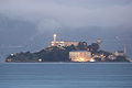 |
37.8266°N 122.4233°W | San Francisco | This 22 acres (8.9 ha) island in San Francisco Bay once served as a lighthouse, a military fortification, a military prison, and as a federal prison until 1963. It is now part of the Golden Gate National Recreation Area Golden Gate National Recreation Area The Golden Gate National Recreation Area is a U.S. National Recreation Area administered by the National Park Service that surrounds the San Francisco Bay area. It is one of the most visited units of the National Park system in the United States, with over 13 million visitors a year... . |
| Angel Island |  |
37.862778°N 122.430833°W | Marin | With an area of 1.2 square miles (3.1 km²), this island in San Francisco Bay processed approximately 1 million immigrants to the U.S. during 1910 to 1940. It is currently a state park California Department of Parks and Recreation The California Department of Parks and Recreation, also known as California State Parks, manages the California state parks system. The system administers 278 parks and 1.4 million acres , with over of coastline; of lake and river frontage; nearly 15,000 campsites; and of hiking, biking, and... . |
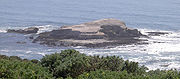
| Año Nuevo Island Año Nuevo Island Año Nuevo Island is a small island off Año Nuevo Point on the coast of Northern California, between San Francisco and Santa Cruz. It is an important breeding site for Northern Elephant Seals and the endangered Steller's Sea Lion, as well as several species of seabirds, including Rhinoceros... |
 |
37.1085588°N 122.3377509°W | San Mateo | Small Pacific island, about 0.2 mile (0.321868 km) long, near Año Nuevo (New Year's) Point, south of the Golden Gate Golden Gate The Golden Gate is the North American strait connecting San Francisco Bay to the Pacific Ocean. Since 1937 it has been spanned by the Golden Gate Bridge... . It is protected by the Año Nuevo State Reserve Año Nuevo State Reserve Año Nuevo State Park is a state park of California, USA, encompassing Año Nuevo Island and Año Nuevo Point, which are known for their pinniped rookeries. Located in San Mateo County, the low, rocky, windswept point juts out into the Pacific Ocean about south of San Francisco and the Golden Gate... as an important habitat for seabirds and other coastal wildlife. |
| Bair Island Bair Island Bair Island is a marsh area in Redwood City, California covering , and includes three islands: Inner, Middle and Outer islands.Bair Island is part of the larger Don Edwards San Francisco Bay National Wildlife Refuge.... |
37.5299362°N 122.2221881°W | San Mateo | This 2600 acres (1,052.2 ha) island in San Francisco Bay near Redwood City Redwood City, California Redwood City is a California charter city located on the San Francisco Peninsula in Northern California, approximately 27 miles south of San Francisco, and 24 miles north of San Jose. Redwood City's history spans from its earliest inhabitation by the Ohlone people, to its tradition as a port for... is part of the Don Edwards San Francisco Bay National Wildlife Refuge Don Edwards San Francisco Bay National Wildlife Refuge Don Edwards San Francisco Bay National Wildlife Refuge is a US National Wildlife Refuge located in the southern part of San Francisco Bay, California. The Refuge headquarters and visitor center is located in the Baylands district of Fremont, next to Coyote Hills Regional Park, in Alameda County. ... . |
|
| Bay Farm Island |  |
37.738°N 122.252°W | Alameda | This former island in San Francisco Bay San Francisco Bay San Francisco Bay is a shallow, productive estuary through which water draining from approximately forty percent of California, flowing in the Sacramento and San Joaquin rivers from the Sierra Nevada mountains, enters the Pacific Ocean... has been connected to the mainland. It is part of the City of Alameda Alameda, California Alameda is a city in Alameda County, California, United States. It is located on Alameda Island and Bay Farm Island, and is adjacent to Oakland in the San Francisco Bay. The Bay Farm Island portion of the city is adjacent to the Oakland International Airport. At the 2010 census, the city had a... . |
| Belvedere Island Belvedere Island Belvedere Island is a rocky island in Marin County, California which was separated by a marsh from the mainland and has now been linked by two spits... |
37.87158°N 122.46849°W | Marin | This former island in Richardson Bay Richardson Bay Richardson Bay is a shallow, ecologically rich arm of San Francisco Bay, managed under a Joint Powers Agency of four Northern California cities. The Richardson Bay Sanctuary was acquired in the early 1960s by the National Audubon Society. The bay was named for William A... has been connected to the mainland. It is part of the City of Belvedere Belvedere, California Belvedere is an affluent city in Marin County, California, United States. Belvedere is located northeast of Sausalito, at an elevation of 36 feet... . |
|
| Bird Island | 37.8240950°N 122.5366415°W | Marin | Small Pacific island between Point Bonita and Rodeo Cove Rodeo Cove -Notes:... . |
|
| Bird Rock Bird Rock (Marin County, California) Bird Rock is a rock formation and a small Pacific island west of Tomales Point in Marin County, California at Its area is roughly .A seabird colony, the island is covered with a layer of guano... |
 |
38.2299191°N 122.9944445°W | Marin | Small Pacific island west of Tomales Point, primarily a seabird colony. It covers 2 acre (0.809372 ha). |
| Brooks Island | 37°53′47"N 122°21′19"W | Contra Costa | A 65 acres (26.3 ha) island in San Francisco Bay south of Richmond Richmond, California Richmond is a city in western Contra Costa County, California, United States. The city was incorporated on August 7, 1905. It is located in the East Bay, part of the San Francisco Bay Area. It is a residential inner suburb of San Francisco, as well as the site of heavy industry, which has been... , protected as part of the Brooks Island Regional Shoreline. |
|
| Brother Islands Brother Islands The Brothers lie roughly off Point San Pablo in San Francisco Bay in Richmond, California. The diseno del Rancho de San Pablo names East Brother Island as 'Isla de Pajaros' or 'Bird Island.'The Brothers, along with The Sisters The Brothers (East and West Brother Island) lie roughly off Point... |
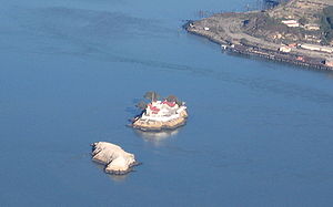 |
37°57′48"N 122°25′59"W | Contra Costa | This pair of islands is located west off Point San Pablo Point San Pablo Point San Pablo is a small historic community isolated at the far end of the Potrero Hills at Point San Pablo in Richmond, California.-Overview:... in Richmond Richmond, California Richmond is a city in western Contra Costa County, California, United States. The city was incorporated on August 7, 1905. It is located in the East Bay, part of the San Francisco Bay Area. It is a residential inner suburb of San Francisco, as well as the site of heavy industry, which has been... . Each is about 300 feet (91.4 m) long. East Brother has a lighthouse and a bed and breakfast Bed and breakfast A bed and breakfast is a small lodging establishment that offers overnight accommodation and breakfast, but usually does not offer other meals. Since the 1980s, the meaning of the term has also extended to include accommodations that are also known as "self-catering" establishments... . |
| Castro Rocks Castro Rocks Castro Rocks are several rocks in Richmond, California protruding from the waters San Francisco Bay between Castro Point and Red Rock Island.The rocks lie almost directly under the Richmond-San Rafael Bridge .... |
37°55′56"N 122°25′07"W | Contra Costa | Beneath the Richmond – San Rafael Bridge. | |
| Coast Guard Island Coast Guard Island Coast Guard Island is in the Oakland Estuary between Oakland and Alameda, California. The island is situated in the historic Brooklyn Basin, now known as Embarcadero Cove. It is within the Alameda city limits, but is accessible, by car, only via a bridge to Dennison Street in Oakland.The Island... |
 |
37°46′56"N 122°15′00"W | Alameda | Located in the Oakland Estuary Oakland Estuary The Oakland Estuary is the body of water separating the cities of Oakland and Alameda, California, in the San Francisco Bay Area. On its western end it connects to San Francisco Bay, while its eastern end connects to San Leandro Bay.-Crossings:... , this 67 acres (27.1 ha) artificial island is part of the City of Alameda. It is home to various United States Coast Guard United States Coast Guard The United States Coast Guard is a branch of the United States Armed Forces and one of the seven U.S. uniformed services. The Coast Guard is a maritime, military, multi-mission service unique among the military branches for having a maritime law enforcement mission and a federal regulatory agency... facilities. |
| Corinthian Island | 37°52′22"N 122°27′32"W | Marin | This former island was joined to the mainland in the 1980s. It is split between the city of Belvedere Belvedere, California Belvedere is an affluent city in Marin County, California, United States. Belvedere is located northeast of Sausalito, at an elevation of 36 feet... and the town of Tiburon Tiburon, California Tiburon is an incorporated town in Marin County, California. It occupies most of the Tiburon Peninsula, which reaches south into the San Francisco Bay. The smaller city of Belvedere occupies the south-east part of the peninsula and is contiguous with Tiburon... . |
|
| East Marin Island Marin Islands Marin Islands are the two islands, East Marin and West Marin, situated offshore from San Rafael, California in the San Pablo Bay extension of San Francisco Bay. The islands comprise the Marin Islands National Wildlife Refuge, which was established in 1992... |
37°57′52"N 122°28′06"W | Marin | Near San Rafael, California San Rafael, California San Rafael is a city and the county seat of Marin County, California, United States. The city is located in the North Bay region of the San Francisco Bay Area... . |
|
| Gull Rock Gull Rock Gull Rock is a rock formation and a small rocky island in Marin County, California, USA, in the Pacific Ocean just offshore of the Golden Gate National Recreation Area.... |
37.8760378°N 122.6163689°W | Marin | A Pacific island near Mount Tamalpais Mount Tamalpais Mount Tamalpais is a peak in Marin County, California, United States, often considered symbolic of Marin County. Much of Mount Tamalpais is protected within public lands such as Mount Tamalpais State Park and the Mount Tamalpais Watershed.-Geography:... , about 200 feet (61 m) long. |
|
| Hog Island (Petaluma River) Hog Island (Petaluma River) Hog Island is an island in the wetlands of the Petaluma River in Sonoma County, California, located at near the Marin County line. San Antonio Creek enters the river just west of this island.... |
38.1590851°N 122.5383142°W | Sonoma | Island in the Petaluma River Petaluma River The Petaluma River is a river in the California counties of Sonoma and Marin that becomes a tidal slough near its mouth. It springs from farmlands southwest of Cotati and flows generally southward through Petaluma's old town and of tidal marshes to end in northwest San Pablo Bay.-History:The word... wetlands. |
|
| Hog Island (Tomales Bay) | 38.1971423°N 122.9358306°W | Marin | A 2 acre (0.809372 ha) island in Tomales Bay Tomales Bay Tomales Bay is a long narrow inlet of the Pacific Ocean in Marin County in northern California in the United States. It is approximately 15 miles long and averages nearly 1.0 miles wide, effectively separating the Point Reyes Peninsula from the mainland of Marin County. It is located... . |
|
| Kent Island Kent Island (California) Kent Island is a small island in Marin County, California. The island is included in the Gulf of the Farallones National Marine Sanctuary.-Location:The island is located within the Bolinas Lagoon, a salt water inlet of the Pacific Ocean... |
 |
37.912148°N 122.6785951°W | Marin | An island in Bolinas Lagoon Bolinas Lagoon Bolinas Lagoon is a tidal estuary, approximately in area, located at in the West Marin region of Marin County, California, United States. It is a part of the Gulf of the Farallones National Marine Sanctuary. The lagoon is a back bay of Bolinas Bay on the Pacific coast approximately 15 mi ... , near the town of Bolinas Bolinas, California Bolinas formerly Juggville is a coastal unincorporated community in Marin County, California in the San Francisco Bay Area. Bolinas is located west-southwest of San Rafael, at an elevation of 36 feet... . About 0.5 mile (0.80467 km) long. |
| Mare Island Mare Island Mare Island is a peninsula in the United States alongside the city of Vallejo, California, about northeast of San Francisco. The Napa River forms its eastern side as it enters the Carquinez Strait juncture with the east side of San Pablo Bay. Mare Island is considered a peninsula because no full... |
 |
38.0954755°N 122.2724704°W | Solano | An island in San Pablo Bay San Pablo Bay San Pablo Bay is a tidal estuary that forms the northern extension of San Francisco Bay in northern California in the United States. Most of the Bay is shallow; however, there is a deep water channel approximately in mid bay, which allows access to Sacramento, Stockton, Benicia, Martinez, and... near Vallejo Vallejo, California Vallejo is the largest city in Solano County, California, United States. The population was 115,942 at the 2010 census. It is located in the San Francisco Bay Area on the northeastern shore of San Pablo Bay... . About 3.5 miles (5.6 km) long, site of a major shipyard. |
| Mussel Rock Mussel Rock right|thumb|Mussel Rock is a rock formation on the coast of San Mateo County, California, offshore from Daly City. It consists of one large and numerous smaller rocks of a type known as a stack, where a headland is eroded unevenly, leaving small islands.... |
 |
37.6668787°N 122.4971961°W | San Mateo | A stack Stack (geology) A stack is a geological landform consisting of a steep and often vertical column or columns of rock in the sea near a coast, isolated by erosion. Stacks are formed through processes of coastal geomorphology, which are entirely natural. Time, wind and water are the only factors involved in the... in the Pacific Ocean near Daly City Daly City, California Daly City is the largest city in San Mateo County, California, United States, with a 2010 population of 101,123. Located immediately south of San Francisco, it is named in honor of businessman and landowner John Daly.-History:... . About 200 feet (61 m) long. |
| Rat Rock | 38°00′16"N 122°27′43"W | Marin | An 18 feet (5.5 m) tall rock north of China Camp China Camp State Park China Camp State Park is a state park of California, USA, surrounding a historic Chinese American shrimp-fishing village and a salt marsh. The park is located in San Rafael, California, on the shore of San Pablo Bay. It is known for its hiking and mountain biking trails, scenic views, and open... . |
|
| Red Rock Island Red Rock Island Red Rock Island is an uninhabited, island in the San Francisco Bay located just south of the Richmond – San Rafael Bridge. The property is the only privately owned island in San Francisco Bay. The boundaries of three counties – San Francisco, Marin and Contra Costa – converge on this high rock... |
 |
37°55′45"N 122°25′51"W | Contra Costa, Marin and San Francisco | This uninhabited 5.8 acres (2.3 ha) island is located in San Francisco Bay just south of the Richmond – San Rafael Bridge, near the meeting point of three counties. It is privately owned. |
| San Pedro Rock San Pedro Rock San Pedro Rock is a rock formation and small island off Point San Pedro in Pacifica, California, in the San Francisco Bay Area's San Mateo County.-See also:* List of islands of California... |
37.5952150°N 122.5241438°W | San Mateo | A Pacific island near the city of Pacifica Pacifica, California Pacifica is a city in San Mateo County, California, on the coast of the Pacific Ocean between San Francisco and Half Moon Bay.-Overview:The City of Pacifica is spread along a six mile stretch of the north central California coastal beach and hills, nestled in several small valleys spanning between... . About 800 feet (243.8 m) long. |
|
| Seal Rocks (San Francisco, California) | 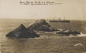 |
37°46′43"N 122°30′58"W | San Francisco | A series of large rocks in the Pacific Ocean that host a sea lion Sea Lion Sea lions are pinnipeds characterized by external ear-flaps, long fore-flippers, the ability to walk on all fours, and short thick hair. Together with the fur seal, they comprise the family Otariidae, or eared seals. There are six extant and one extinct species in five genera... colony. |
| Seal Rock (San Mateo County, California) Seal Rock (San Mateo County, California) Seal Rock is a small island in San Mateo County, California.-See also:*List of islands of California... |
37.3916088°N 122.4246974°W | San Mateo | A Pacific island south of Half Moon Bay Half Moon Bay (California) Half Moon Bay is a bay of the Pacific Ocean on the coast of San Mateo County, California. The bay is approximately semi-circular, hence the name half moon, with sea access to the south... , about 500 feet (152.4 m) long. |
|
| Sears Rock Sears Rock Sears Rock is a small rocky island in Marin County, California.-See also:* List of islands of California... |
37.8285393°N 122.5491423°W | Marin | A rock in the Centissima Reef Centissima Reef Centissima Reef is the reef which surrounds Sears Rock in Marin County, California.... . |
|
| The Sisters | 37.9882561°N 122.4410844°W | Marin | A pair of small islands in San Pablo Bay San Pablo Bay San Pablo Bay is a tidal estuary that forms the northern extension of San Francisco Bay in northern California in the United States. Most of the Bay is shallow; however, there is a deep water channel approximately in mid bay, which allows access to Sacramento, Stockton, Benicia, Martinez, and... , 2000 feet (609.6 m) south of Point Saint Pedro. |
|
| Treasure Island Treasure Island, California Treasure Island is an artificial island in the San Francisco Bay between San Francisco and Oakland, and an emerging neighborhood of San Francisco.... |
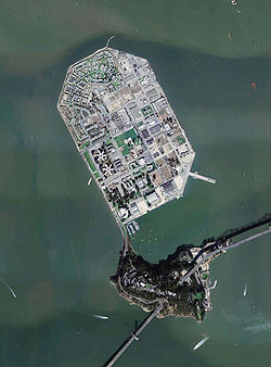 |
37°49′29"N 122°22′16"W | San Francisco | This 403 acres (163.1 ha) artificial island in San Francisco Bay is tied to Yerba Buena Island. It was dredged out of the bay to house the Golden Gate International Exposition Golden Gate International Exposition The Golden Gate International Exposition , held at San Francisco, California's Treasure Island, was a World's Fair that celebrated, among other things, the city's two newly-built bridges. The San Francisco – Oakland Bay Bridge was dedicated in 1936 and the Golden Gate Bridge was dedicated in 1937... of 1939-40. |
| West Marin Island Marin Islands Marin Islands are the two islands, East Marin and West Marin, situated offshore from San Rafael, California in the San Pablo Bay extension of San Francisco Bay. The islands comprise the Marin Islands National Wildlife Refuge, which was established in 1992... |
37°57′57"N 122°28′22"W | Marin | Near San Rafael, California San Rafael, California San Rafael is a city and the county seat of Marin County, California, United States. The city is located in the North Bay region of the San Francisco Bay Area... . |
|
| Yerba Buena Island Yerba Buena Island Yerba Buena Island sits in the San Francisco Bay between San Francisco and Oakland, California. The Yerba Buena Tunnel runs through its center and connects the western and eastern spans of the San Francisco-Oakland Bay Bridge. It has had several other names over the decades: Sea Bird Island, Wood... |
37°48′36"N 122°21′58"W | San Francisco | This island in San Francisco Bay is home to a Coast Guard United States Coast Guard The United States Coast Guard is a branch of the United States Armed Forces and one of the seven U.S. uniformed services. The Coast Guard is a maritime, military, multi-mission service unique among the military branches for having a maritime law enforcement mission and a federal regulatory agency... station. The San Francisco – Oakland Bay Bridge passes through it by means of a tunnel. |
Suisun BaySuisun BaySuisun Bay is a shallow tidal estuary at in northern California, USA. It lies at the confluence of the Sacramento and San Joaquin Rivers, forming the entrance to the Sacramento-San Joaquin River Delta, an inverted river delta...
| Island | Image | Coordinates | County | Description |
|---|---|---|---|---|
| Chipps Island | 38.0551975°N 121.911904°W | Solano | ||
| Dutton Island | 38.0815855°N 121.9705172°W | Solano | ||
| Freeman Island | 38.0793632°N 121.9857955°W | Solano | ||
| Grizzly Island | 38.1513054°N 121.9727407°W | Solano | ||
| Hammond Island | 38.1049181°N 121.9374611°W | Solano | ||
| Joice Island | 38.149917°N 122.0594097°W | Solano | A marshy island 6 miles (9.7 km) long, north of Grizzly Bay Grizzly Bay Grizzly Bay is a baylet of the San Francisco Bay which dips into Solano County, California and borders Suisun Bay. Grizzly Bay is home to many sloughs and wildlife areas in addition to the 5th Reserve Fleet which is docked off the coast of Benicia.... . |
|
| Morrow Island | 38.116585°N 122.086354°W | Solano | ||
| Roe Island Roe Island Roe Island is an island in Suisun Bay at the mouth of the Sacramento-San Joaquin River Delta in Solano County, California, 10 km east of Benicia. Its western tip is named Preston Point and its eastern tip is Gillespie Point.... |
38.0724192°N 122.0346857°W | Solano | In Suisun Bay. | |
| Ryer Island Ryer Island (Suisun Bay) Ryer Island is an island in Suisun Bay at the mouth of the Sacramento-San Joaquin River Delta in Solano County, California, in the Suisun Resource Conservation District, eight miles east-northeast of Benicia. At the time of statehood it was known as Kings Island.-External links:... |
38.0826966°N 122.0144075°W | Solano | 475 hectares (1,173.7 acre) island, between Suisun Bay Suisun Bay Suisun Bay is a shallow tidal estuary at in northern California, USA. It lies at the confluence of the Sacramento and San Joaquin Rivers, forming the entrance to the Sacramento-San Joaquin River Delta, an inverted river delta... and Suisun Cutoff. About 2 miles (3.2 km) long. |
|
| Seal Islands Seal Islands Seal Islands are a pair of islands in Suisun Bay at the mouth of the Sacramento-San Joaquin River Delta in Contra Costa County, California, 10 km east of Benicia, and 500 metres off-shore from the former Concord Naval Weapons Station and Port Chicago Naval Magazine.... |
38.0554754°N 122.0471858°W | Contra Costa | In Suisun Bay. | |
| Simmons Island | 38.0968627°N 121.9905181°W | Solano | ||
| Snag Island | 38.072696°N 121.9755173°W | Solano | ||
| Van Sickle Island | 38.066586°N 121.9010705°W | Solano | An island 2.5 miles (4 km) long at the junction of the Sacramento River, San Joaquin River, and Suisun Bay. | |
| Wheeler Island | 38.0849187°N 121.9374608°W | Solano |
Miscellanea
| Island | Image | Coordinates | Description |
|---|---|---|---|
| Rincon Island Rincon Island, California Rincon Island is an artificial island located off Rincon Beach in Ventura County, California on public land leased from the California State Lands Commission . The island is situated approximately offshore in of water. The island was constructed in 1958 for the specific purpose of well drilling... |
 |
34.3474966°N 119.4453965°W | A 1 acre (0.404686 ha) artificial island off the coast of Ventura County Ventura County, California Ventura County is a county in the southern part of the U.S. state of California. It is located on California's Pacific coast. It is often referred to as the Gold Coast, and has a reputation of being one of the safest populated places and one of the most affluent places in the country... , leased for oil and gas production. |
See also
- Coastal islands of Alta and Baja CaliforniaCoastal islands of Alta and Baja CaliforniaThis is a list of notable Coastal islands of the Californias - coastal islands west of California and the Baja California Peninsula in the Pacific Ocean. California is in the United States; and the Baja California Peninsula includes the states of Baja California Sur and Baja California in Mexico...
- Geography of CaliforniaGeography of CaliforniaCovering an area of , California is geographically diverse. The Sierra Nevada Mountains, the fertile farmlands of the Central Valley, and the arid Mojave Desert of the south are some of the major geographic features of this U.S. state. It is home to some of the world's most exceptional trees: the...
- List of islands of the United States
- Outline of CaliforniaOutline of Californiathumb|The location of the [[California|state of California]] in the [[United States|United States of America]]thumb|An enlargeable map of the [[California|state of California]]The following outline is provided as an overview of and topical guide to the U.S...
External links
- Delta Waterways at California Department of Water ResourcesCalifornia Department of Water ResourcesThe California Department of Water Resources , is a department within the California Natural Resources Agency. The Department of Water Resources is responsible for the State of California's management and regulation of water usage...