
Mare Island
Encyclopedia
Peninsula
A peninsula is a piece of land that is bordered by water on three sides but connected to mainland. In many Germanic and Celtic languages and also in Baltic, Slavic and Hungarian, peninsulas are called "half-islands"....
in the United States
United States
The United States of America is a federal constitutional republic comprising fifty states and a federal district...
alongside the city of Vallejo, California
Vallejo, California
Vallejo is the largest city in Solano County, California, United States. The population was 115,942 at the 2010 census. It is located in the San Francisco Bay Area on the northeastern shore of San Pablo Bay...
, about 23 miles (37 km) northeast of San Francisco. The Napa River
Napa River
The Napa River, approximately 55 miles long, is a river in the U.S. state of California. It drains a famous wine-growing region, called the Napa Valley, in the mountains northeast of San Francisco. Milliken Creek is a tributary of the Napa River....
forms its eastern side as it enters the Carquinez Strait
Carquinez Strait
The Carquinez Strait is a narrow tidal strait in northern California. It is part of the tidal estuary of the Sacramento and the San Joaquin rivers as they drain into the San Francisco Bay...
juncture with the east side of San Pablo Bay
San Pablo Bay
San Pablo Bay is a tidal estuary that forms the northern extension of San Francisco Bay in northern California in the United States. Most of the Bay is shallow; however, there is a deep water channel approximately in mid bay, which allows access to Sacramento, Stockton, Benicia, Martinez, and...
. Mare Island is considered a peninsula
Peninsula
A peninsula is a piece of land that is bordered by water on three sides but connected to mainland. In many Germanic and Celtic languages and also in Baltic, Slavic and Hungarian, peninsulas are called "half-islands"....
because no full body of water separates this or several other named "islands" from the mainland. Instead, a series of small sloughs
River delta
A delta is a landform that is formed at the mouth of a river where that river flows into an ocean, sea, estuary, lake, reservoir, flat arid area, or another river. Deltas are formed from the deposition of the sediment carried by the river as the flow leaves the mouth of the river...
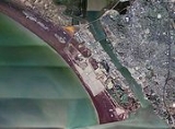
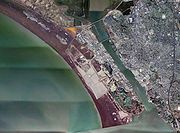
cause seasonal water-flows among the so-called islands. Mare Island is the largest of these at about 3.5 miles (5.6 km) long and a mile wide.
The Napa River widens and forms a harbor between Mare Island and the mainland.
History
In 1775, a Spanish explorer, Perez Ayala became the first European to land on what would become Mare Island. This area was part of Rancho Suscol, deeded to General Mariano Guadalupe VallejoMariano Guadalupe Vallejo
Mariano Guadalupe Vallejo was a Californian military commander, politician, and rancher. He was born a subject of Spain, performed his military duties as an officer of Mexico, and shaped the transition of California from a Mexican district to an American state...
in 1844. Originally named Isla de la Plana by Ayala, the island became a waypoint for early settlers. In 1835, whilst traversing the Carquinez Strait
Carquinez Strait
The Carquinez Strait is a narrow tidal strait in northern California. It is part of the tidal estuary of the Sacramento and the San Joaquin rivers as they drain into the San Francisco Bay...
, a crude ferry transporting men and livestock capsized in a squall, among the livestock feared lost in the wreckage was General Mariano Guadalupe Vallejo's
Mariano Guadalupe Vallejo
Mariano Guadalupe Vallejo was a Californian military commander, politician, and rancher. He was born a subject of Spain, performed his military duties as an officer of Mexico, and shaped the transition of California from a Mexican district to an American state...
, Mexican Commandante for Northern California, prized white mare. Several days later, General Vallejo's mare was found on the island, having swum ashore. The island was renamed by Vallejo to Isla de la Yegua, Spanish for Mare Island in her honor.
Shipyard
In 1850, Commodore John Drake Sloat was ordered to lead a survey party in quest of a logical site for the nation's first Pacific naval installation. Sloat recommended the island across the Napa River from the settlement of Vallejo; it being "free from ocean gales and from floods and freshets."On November 6, 1850, two months after California was admitted to statehood, President Fillmore reserved Mare Island for government use. The U.S. Navy Department acted favorably on Commodore Sloat's recommendations and Mare Island was purchased in July, 1852, for the sum of $83,410 for the use as a naval shipyard. Two years later, on September 16, 1854, Mare Island became the first permanent U.S. naval installation on the west coast
West Coast of the United States
West Coast or Pacific Coast are terms for the westernmost coastal states of the United States. The term most often refers to the states of California, Oregon, and Washington. Although not part of the contiguous United States, Alaska and Hawaii do border the Pacific Ocean but can't be included in...
, with Commodore David G. Farragut, as Mare Island's first base commander.
For more than a century, Mare Island was the United States Navy
United States Navy
The United States Navy is the naval warfare service branch of the United States Armed Forces and one of the seven uniformed services of the United States. The U.S. Navy is the largest in the world; its battle fleet tonnage is greater than that of the next 13 largest navies combined. The U.S...
's Mare Island Naval Shipyard
Mare Island Naval Shipyard
The Mare Island Naval Shipyard was the first United States Navy base established on the Pacific Ocean. It is located 25 miles northeast of San Francisco in Vallejo, California. The Napa River goes through the Mare Island Strait and separates the peninsula shipyard from the main portion of the...
. The growing size and number of the country's naval fleet was making older facilities obsolete and led to increased building and refitting of shipyards nationally. A 508 feet (154.8 m) drydock was built by the Public Works Department on an excellent rock foundation of cut granite blocks. The work took nineteen years and was completed in 1891. During the Spanish-American War
Spanish-American War
The Spanish–American War was a conflict in 1898 between Spain and the United States, effectively the result of American intervention in the ongoing Cuban War of Independence...
, a concrete drydock on wooden piles, 740 feet (225.6 m) long, was completed after eleven years of work, in 1910. By 1941, a third drydock had been completed and the drydock number four was under construction. The ammunition depot and submarine repair base were modern, fireproof buildings. A million dollar, three-way vehicle causeway to Vallejo replaced a ferry service
Vallejo (ferry)
The Vallejo, originally known as the O&CRR Ferry No. 2, is a houseboat in Sausalito, California, United States. It previously served as a passenger ferry in Portland, Oregon, in the late 19th century, and in Vallejo, California, for the first half of the 20th century.The Oregon & California...
.
Before World War II
World War II
World War II, or the Second World War , was a global conflict lasting from 1939 to 1945, involving most of the world's nations—including all of the great powers—eventually forming two opposing military alliances: the Allies and the Axis...
, Mare Island had been in a continual state of upbuilding. By 1941, new projects included improvements to the central power plant, a new pattern storage building, a large foundry, machine shop, magazine building, paint shop, new administration building, and a huge storehouse. The yard was expected to be able to repair and paint six to eight large naval vessels at a time. Several finger piers had recently been built, as well as a new shipbuilding wharf, adding one 500 feet (152.4 m) and a 750 feet (228.6 m) berth. It employed 5593 workers at the beginning of 1939, and rapidly increased to 18,500 busily engaged by May 1941, with a monthly payroll of $3,500,000. Then came Pearl Harbor
Pearl Harbor
Pearl Harbor, known to Hawaiians as Puuloa, is a lagoon harbor on the island of Oahu, Hawaii, west of Honolulu. Much of the harbor and surrounding lands is a United States Navy deep-water naval base. It is also the headquarters of the U.S. Pacific Fleet...
. In 1941, the drafting department had expanded to three buildings accommodating over 400 Naval architects, engineers and draftsmen. The hospital carried 584 bed patients.
In 1969, the US Navy transferred its (Vietnam War) Brown Water Navy Riverine Training Forces from Coronado, California
Coronado, California
Coronado, also known as Coronado Island, is an affluent resort city located in San Diego County, California, 5.2 miles from downtown San Diego. Its population was 24,697 at the 2010 census, up from 24,100 at the 2000 census. U.S. News and World Report lists Coronado as one of the most expensive...
, to Mare Island. Swift Boats (Patrol Craft Fast-PCF), and PBRs (Patrol Boat River), among other types of riverine craft, conducted boat operations throughout the currently named Napa-Sonoma Marshes State Wildlife Area
Napa Sonoma Marsh
The Napa Sonoma Marsh is a wetland at the northern edge of San Pablo Bay, which is a northern arm of the San Francisco Bay in California, USA. This marsh has an area of 48,000 acres , of which 13,000 acres are abandoned salt evaporation ponds...
, which are located on the north and west portions of Mare Island. Mare Island Naval Base was deactivated during the 1995 cycle of US base closures, but the US Navy Reserves still have access to the water portions of the State Wildlife Area for any riverine warfare training being conducted from their new base in Sacramento, California
Sacramento, California
Sacramento is the capital city of the U.S. state of California and the county seat of Sacramento County. It is located at the confluence of the Sacramento River and the American River in the northern portion of California's expansive Central Valley. With a population of 466,488 at the 2010 census,...
.
Restoration and reuse
In 1993, Congress approved the findings of the Base Realignment and ClosureBase Realignment and Closure
Base Realignment and Closure is a process of the United States federal government directed at the administration and operation of the Armed Forces, used by the United States Department of Defense and Congress to close excess military installations and realign the total asset inventory to reduce...
report, leading to the closure of Mare Island Naval Shipyard. The shipyard had long been the economic engine of the city of Vallejo, having reached an employment peak of 40,000 workers during World War II, and even employing 10,000 workers after scaling back in 1988. When Congress ordered the base closure, the shipyard employed 5,800 workers.
The vision of rebuilding Mare Island as a vital place where people lived and worked was a key goal in the base conversion planning process undertaken by the city of Vallejo
Vallejo, California
Vallejo is the largest city in Solano County, California, United States. The population was 115,942 at the 2010 census. It is located in the San Francisco Bay Area on the northeastern shore of San Pablo Bay...
in the early 1990s.
Preservation of many of Mare Island’s 661 structures and other cultural resources was an additional factor in the planning process. As the oldest shipyard and naval facility on the West Coast, the shipyard earned a National Historic Landmark
National Historic Landmark
A National Historic Landmark is a building, site, structure, object, or district, that is officially recognized by the United States government for its historical significance...
designation by the federal government in 1975. In 1979, California listed the entire naval base as a State Historical Landmark.
California Historical Landmark
California Historical Landmarks are buildings, structures, sites, or places in the state of California that have been determined to have statewide historical significance by meeting at least one of the criteria listed below:...
In 1999, the city of Vallejo added Mare Island to the National Register of Historic Districts with 42 individual city landmarks.
Finally, as with any restoration of an industrial, brownfield landscape, both city and government agencies required environmental review, toxics removal, and soil mediation before any new development and reuse.
In 1998, the city of Vallejo contracted with Lennar Mare Island LLC to redevelop the island’s 5657 acres (22.9 km²) into a multi-use community. Lennar Corporation contracted the Sausalito-based SWA Group, to provide a Master Development Plan for Vallejo, additional historical research and landscape architectural services.
The final land-use plan SWA submitted to the city of Vallejo in 2005 divided Mare Island into 13 specific zones, including a university district, and industrial zone, historic core, and residential neighborhoods. In addition, 78% of the entire island was set aside for wildlife habitat and wetlands, parkland and open space, and dredge ponds.
SWA’s site plan began with the island’s grid of small, tree-lined streets and extended them so that they terminate in dramatic views of the bay and river and a new public waterfront. The historic core was repurposed as a new town center with retail, entertainment attractions, and additional, higher-density housing. Other improvements included a new grove of Canary Island Palm trees and London Plane trees along the G Street corridor, one of two entry points on the island. This feature enhances a visitor’s sense of arrival and frames the long view of Mt. Tamalpais across the San Pablo Bay.
In 2007, Lennar Corp finished construction on three new residential neighborhoods. Farragut Village, with 277 new homes in a site layout and landscape pattern designed by SWA Group, was the first completed neighborhood. Additional neighborhoods include Coral Sea and Kirkland Isle II. When all construction is complete, Mare Island will have 1,400 homes and condos, plus 7000000 square feet (650,321.3 m²) of commercial, retail, entertainment, and industrial space.
Mare Island’s new residents petitioned Lennar Corp. and the city of Vallejo to drop the dredge ponds, whose role had been to collect silt, drainage, and storm water from both the Napa River and the Bay and instead restore that acreage to wetlands. Both city officials and the developer agreed and in January 2006, the land use plan was amended to add the Mare Island Shoreline Heritage Preserve. An advisory board was appointed by the city to restore the 215 acre (0.8700749 km²) site into publicly accessible parkland.
Overall, the conversion and reuse of Mare Island will result in the 3075 acres (12.4 km²) of protected tidal and nontidal wetlands providing wintering habitat for thousands of shorebirds and waterfowl. For example, during the migrating season in February 2008, thousands of people attended the three-day San Francisco Bay Flyway Festival on Mare Island, cosponsored by Lennar Mare Island LLC. The event, which included an art show, exhibitors, and music, marked the annual return of more than a million shorebirds, ducks, geese, and hawks to the Bay Area.
Access
Mare Island can be accessed by State Route 37California State Route 37
State Route 37 is a state highway in the northern part of the U.S. state of California that runs 21 miles along the northern shore of San Pablo Bay. It is built from U.S. Route 101 in Novato and runs through the southern tips of Sonoma and Napa Counties to Interstate 80 in Vallejo...
on its north side, as well as by Interstate 80 via the Mare Island Causeway and Tennessee Street, a designated route.
Mare Island is also the location of Touro University California, the US Forest Service Pacific Southwest Regional Office, and the new administrative offices of the Vallejo City Unified School District.
For information on visiting Mare Island, see:
For information on the Historic Nature of Vallejo, see:
Further reading
- Holzer, T.L. et al. (2002). Comments on potential geologic and seismic hazards affecting Mare Island, Solano County, California [U.S. Geological Survey Open-File Report 02-425]. Menlo Park, CA: U.S. Department of the Interior, U.S. Geological Survey.