
Petaluma River
Encyclopedia

California
California is a state located on the West Coast of the United States. It is by far the most populous U.S. state, and the third-largest by land area...
counties of Sonoma
Sonoma County, California
Sonoma County, located on the northern coast of the U.S. state of California, is the largest and northernmost of the nine San Francisco Bay Area counties. Its population at the 2010 census was 483,878. Its largest city and county seat is Santa Rosa....
and Marin
Marin County, California
Marin County is a county located in the North San Francisco Bay Area of the U.S. state of California, across the Golden Gate Bridge from San Francisco. As of 2010, the population was 252,409. The county seat is San Rafael and the largest employer is the county government. Marin County is well...
that becomes a tidal slough
River delta
A delta is a landform that is formed at the mouth of a river where that river flows into an ocean, sea, estuary, lake, reservoir, flat arid area, or another river. Deltas are formed from the deposition of the sediment carried by the river as the flow leaves the mouth of the river...
near its mouth. It springs from farmlands southwest of Cotati
Cotati, California
Cotati is an incorporated city in Sonoma County, California, U.S.A., located about north of San Francisco in the 101 corridor between Rohnert Park and Petaluma....
and flows generally southward through Petaluma's
Petaluma, California
Petaluma is a city in Sonoma County, California, in the United States. In the 2010 Census the population was 57,941.Located in Petaluma is the Rancho Petaluma Adobe, a National Historic Landmark. It was built beginning in 1836 by General Mariano Guadalupe Vallejo, then Commandant of the San...
old town and 10 mi (16 km) of tidal marsh
Tidal marsh
A tidal marsh is a type of marsh that is found along coasts and estuaries of which the flooding characteristics are determined by the tidal movement of the adjacent estuary, sea or ocean . According to the salinity of the flooding water, freshwater, brackish and saline tidal marshes are...
es to end in northwest San Pablo Bay
San Pablo Bay
San Pablo Bay is a tidal estuary that forms the northern extension of San Francisco Bay in northern California in the United States. Most of the Bay is shallow; however, there is a deep water channel approximately in mid bay, which allows access to Sacramento, Stockton, Benicia, Martinez, and...
.
History
The word Petaluma, may derive from the MiwokMiwok
Miwok can refer to any one of four linguistically related groups of Native Americans, native to Northern California, who spoke one of the Miwokan languages in the Utian family...
words pe’ta, flat, and luma, back. The Miwok people lived in Sonoma County for more than 2500 years. Petaluma was the name of a village on a low hill east of Petaluma creek and north east of the present day town of Petaluma.
The first recorded exploration of the Petaluma River was by Captain Fernando Quiros in October, 1776. While other members of his Spanish expedition collected adobe and timber for the new Presidio of San Francisco
Presidio of San Francisco
The Presidio of San Francisco is a park on the northern tip of the San Francisco Peninsula in San Francisco, California, within the Golden Gate National Recreation Area...
and for the Mission San Francisco de Asís
Mission San Francisco de Asís
Mission San Francisco de Asís, or Mission Dolores, is the oldest surviving structure in San Francisco and the sixth religious settlement established as part of the California chain of missions...
(Mission Dolores), Quiros and his sailors tried unsuccessfully to sail from San Pablo Bay to Bodega Bay.
Petaluma River Watershed
Located in southern Sonoma County, California, and a portion of northeastern MarinMarin County, California
Marin County is a county located in the North San Francisco Bay Area of the U.S. state of California, across the Golden Gate Bridge from San Francisco. As of 2010, the population was 252,409. The county seat is San Rafael and the largest employer is the county government. Marin County is well...
, the Petaluma River Watershed drains 146 square miles (378.1 km²). The watershed is approximately 19 miles (30.6 km) long and 13 miles (20.9 km) wide with the City of Petaluma near its center. At 2295 feet (699.5 m), Sonoma Mountain
Sonoma Mountain
Sonoma Mountain is a prominent landform within the Sonoma Mountains of southern Sonoma County, California. At elevation of , Sonoma Mountain offers expansive views of the Pacific Ocean to the west and the Sonoma Valley to the east...
is the highest point in the watershed, and its western slopes drain to the Petaluma River by way of tributaries such as Lichau Creek
Lichau Creek
Lichau Creek is an southwest-flowing stream in Sonoma County, California, United States which flows through the town of Penngrove and discharges into the Petaluma River....
, Lynch Creek
Lynch Creek
Lynch Creek is a stream in Sonoma County, California, United States which discharges into the Petaluma River.-Course:Lynch Creek rises on the west flank of Sonoma Mountain and descends initially to the west. It flows under Sonoma Mountain Road, then turns southward and roughly parallels Lynch Road...
, Washington Creek
Washington Creek
Washington Creek is a southward-flowing stream in Sonoma County, California, United States which enters the city of Petaluma and discharges to the Petaluma River.-Course:...
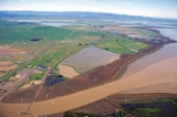
, and Adobe Creek. The lower 12 miles (19.3 km) of the Petaluma River flow through the Petaluma Marsh, the largest remaining salt marsh in San Pablo Bay. The marsh covers 5000 acres (20.2 km²) and is surrounded by approximately 7000 acres (28.3 km²) of reclaimed wetlands. In the marshes west of Lakeville
Lakeville, California
Lakeville is an unincorporated community in Sonoma County, California, United States. It is located near the Petaluma River about southeast of Petaluma....
, the river is joined by San Antonio Creek
San Antonio Creek (Marin County, California)
San Antonio Creek is an eastward-flowing stream in the California counties of Marin and Sonoma that forms part of the boundary between those counties. It empties into the Petaluma River....
, at which point it becomes the boundary between Marin County and Sonoma County. The river flows under State Route 37
California State Route 37
State Route 37 is a state highway in the northern part of the U.S. state of California that runs 21 miles along the northern shore of San Pablo Bay. It is built from U.S. Route 101 in Novato and runs through the southern tips of Sonoma and Napa Counties to Interstate 80 in Vallejo...
at Green Point and enters northwest San Pablo Bay just north of Petaluma Point.
While the river's source lies over 300 ft (91.4 m) above sea level
Sea level
Mean sea level is a measure of the average height of the ocean's surface ; used as a standard in reckoning land elevation...
, it descends to 50 ft (15 m) within about 0.4 mi (643.7 m). The river is fully tidal 11 mi (18 km) from its mouth, indicating its slight gradient through the marshes below Petaluma. The United States Army Corps of Engineers
United States Army Corps of Engineers
The United States Army Corps of Engineers is a federal agency and a major Army command made up of some 38,000 civilian and military personnel, making it the world's largest public engineering, design and construction management agency...
dredges this section to keep it navigable
Navigability
A body of water, such as a river, canal or lake, is navigable if it is deep, wide and slow enough for a vessel to pass. Preferably there are few obstructions such as rocks or trees to avoid. Bridges must have sufficient clearance. High water speed may make a channel unnavigable. Waters may be...
by gravel barge
Barge
A barge is a flat-bottomed boat, built mainly for river and canal transport of heavy goods. Some barges are not self-propelled and need to be towed by tugboats or pushed by towboats...
s and pleasure craft.
Ecology
The Petaluma River Watershed hosts several federally endangered animals including the Salt marsh harvest mouseSalt Marsh Harvest Mouse
The Salt Marsh Harvest Mouse , also known as the Red-bellied Harvest Mouse and some times called by Saltmarsh Harvest Mouse, is an endangered rodent endemic to the San Francisco Bay Area salt marshes in California. There are two distinct subspecies, both endangered and listed together on federal...
(Reithrodontomys raviventris), Peregrine Falcon
Peregrine Falcon
The Peregrine Falcon , also known as the Peregrine, and historically as the Duck Hawk in North America, is a widespread bird of prey in the family Falconidae. A large, crow-sized falcon, it has a blue-gray back, barred white underparts, and a black head and "moustache"...
(Falco peregrinus anatum), California Clapper Rail
California Clapper Rail
The California Clapper Rail is an endangered subspecies of the Clapper Rail . It is found principally in California's San Francisco Bay, and also in Monterey Bay and Morro Bay...
(Rallus longirostris obsoletus), Winter-Run Chinook salmon
Chinook salmon
The Chinook salmon, Oncorhynchus tshawytscha, is the largest species in the pacific salmon family. Other commonly used names for the species include King salmon, Quinnat salmon, Spring salmon and Tyee salmon...
(Oncorhynchus tshawytscha). Endangered flora include Soft Bird’s-Beak (Cordylanthus mollis ssp. mollis), Baker’s Stickyseed (Blennosperma bakeri
Blennosperma bakeri
Blennosperma bakeri is a rare species of flowering plant in the daisy family known by the common names Baker's stickyseed and Sonoma sunshine. It is endemic to Sonoma County, California, where it is known from a few remaining vernal pool sites on the wet grasslands of the Laguna de Santa Rosa and...
), Burke’s Goldfields (Lasthenia burkei
Lasthenia burkei
Lasthenia burkei is a rare species of flowering plant in the daisy family known by the common names Burke's goldfields and Burke's baeria. It is endemic to California, where it is known from three counties north of the San Francisco Bay Area. It grows in moist spring meadows and vernal pools...
), Showy Indian clover (Trifolium amoenum), Sebastopol meadowfoam
Sebastopol meadowfoam
Limnanthes vinculans, or Sebastopol meadowfoam, is an endangered species of meadowfoam found only in the Laguna de Santa Rosa in Sonoma County, California, USA and an area slightly to the south in the Americano Creek and Washoe Creek watersheds...
(Limnanthes vinculans).
The Steelhead trout (Oncorhyncus mykiss) that spawn and rear in the Petaluma River watershed are wild, not hatchery, stock. Chinook are seen in the main stem of the Petaluma River and The United Anglers of Casa Grande High School have seen chinook at the turning basin, near the Lynch Creek confluence. The high school students constructed a salmonid hatchery in 1993 and in 2002 74 Chinook salmon returned to spawn in the Adobe Creek tributary.
Habitat and pollution
The marshMarsh
In geography, a marsh, or morass, is a type of wetland that is subject to frequent or continuous flood. Typically the water is shallow and features grasses, rushes, reeds, typhas, sedges, other herbaceous plants, and moss....
es provide an important wildlife habitat and fish hatchery
Hatchery
A hatchery is a facility where eggs are hatched under artificial conditions, especially those of fish or poultry. It may be used for ex-situ conservation purposes, i.e. to breed rare or endangered species under controlled conditions; alternatively, it may be for economic reasons A hatchery is a...
. However, since the onset of intensive European immigration in the mid-1850s, the water quality
Water quality
Water quality is the physical, chemical and biological characteristics of water. It is a measure of the condition of water relative to the requirements of one or more biotic species and or to any human need or purpose. It is most frequently used by reference to a set of standards against which...
has diminished, partly due to overgrazing
Overgrazing
Overgrazing occurs when plants are exposed to intensive grazing for extended periods of time, or without sufficient recovery periods. It can be caused by either livestock in poorly managed agricultural applications, or by overpopulations of native or non-native wild animals.Overgrazing reduces the...
and other agricultural uses. Pollutants
Water pollution
Water pollution is the contamination of water bodies . Water pollution occurs when pollutants are discharged directly or indirectly into water bodies without adequate treatment to remove harmful compounds....
present in the river include nitrate
Nitrate
The nitrate ion is a polyatomic ion with the molecular formula NO and a molecular mass of 62.0049 g/mol. It is the conjugate base of nitric acid, consisting of one central nitrogen atom surrounded by three identically-bonded oxygen atoms in a trigonal planar arrangement. The nitrate ion carries a...
s, phosphate
Phosphate
A phosphate, an inorganic chemical, is a salt of phosphoric acid. In organic chemistry, a phosphate, or organophosphate, is an ester of phosphoric acid. Organic phosphates are important in biochemistry and biogeochemistry or ecology. Inorganic phosphates are mined to obtain phosphorus for use in...
s, petroleum hydrocarbons, pesticide
Pesticide
Pesticides are substances or mixture of substances intended for preventing, destroying, repelling or mitigating any pest.A pesticide may be a chemical unicycle, biological agent , antimicrobial, disinfectant or device used against any pest...
s and sediment
Sediment
Sediment is naturally occurring material that is broken down by processes of weathering and erosion, and is subsequently transported by the action of fluids such as wind, water, or ice, and/or by the force of gravity acting on the particle itself....
. Urban runoff, particularly from the City of Petaluma, adds heavy metals
Heavy metals
A heavy metal is a member of a loosely-defined subset of elements that exhibit metallic properties. It mainly includes the transition metals, some metalloids, lanthanides, and actinides. Many different definitions have been proposed—some based on density, some on atomic number or atomic weight,...
and hydrocarbons to the river. Starting about 1990, material steps were taken to mitigate the pollution. However, continuing population growth
Overpopulation
Overpopulation is a condition where an organism's numbers exceed the carrying capacity of its habitat. The term often refers to the relationship between the human population and its environment, the Earth...
makes it difficult to attain the State of California's
California
California is a state located on the West Coast of the United States. It is by far the most populous U.S. state, and the third-largest by land area...
water quality goals.
Bridges
BridgeBridge
A bridge is a structure built to span physical obstacles such as a body of water, valley, or road, for the purpose of providing passage over the obstacle...
s span the Petaluma River at the following locations: State Route 37, U.S. 101, Corona Road, Petaluma Boulevard North, and four places in Petaluma (D Street, Payran Street, Washington Street, and Lakeville Street). The longest of these, the 4-lane State Route 37 bridge, is 2183 ft (665.4 m) long and was built in 1958. The oldest bridge, built in 1925, is a 114 ft (34.7 m) concrete triple span carrying two lanes of Petaluma Boulevard North.
See also
- Endangered speciesEndangered speciesAn endangered species is a population of organisms which is at risk of becoming extinct because it is either few in numbers, or threatened by changing environmental or predation parameters...
- List of rivers in California
- List of watercourses in the San Francisco Bay Area
- WetlandWetlandA wetland is an area of land whose soil is saturated with water either permanently or seasonally. Wetlands are categorised by their characteristic vegetation, which is adapted to these unique soil conditions....