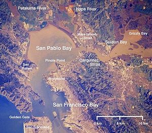
Suisun Bay
Encyclopedia


Sacramento River
The Sacramento River is an important watercourse of Northern and Central California in the United States. The largest river in California, it rises on the eastern slopes of the Klamath Mountains, and after a journey south of over , empties into Suisun Bay, an arm of the San Francisco Bay, and...
and San Joaquin River
San Joaquin River
The San Joaquin River is the largest river of Central California in the United States. At over long, the river starts in the high Sierra Nevada, and flows through a rich agricultural region known as the San Joaquin Valley before reaching Suisun Bay, San Francisco Bay, and the Pacific Ocean...
s, forming the entrance to the Sacramento-San Joaquin River Delta, an inverted river delta
Inverted river delta
An inverted river delta is special category of river delta in which the narrow end of the delta emerges on the seafront and the wide end is located further inland, so that with respect to the seafront, the locations of both ends of the delta are inverted....
. Suisun Marsh
Suisun Marsh
Located in northern California the Suisun Marsh is the largest brackish marsh on west coast of the United States of America. The marsh land is part of the San Francisco Bay tidal estuary, and subject to tidal ebb and flood...
, the tidal marsh land to the north, is the largest marsh in California.
The bay was named in 1811, after the Suisunes
Suisunes
The Suisunes were a tribe of Native Americans that lived in Northern California's Suisun Marsh regions of Solano County, California between what is now Suisun City, Vacaville and Putah Creek around 200 years ago. The Suisunes' main village, Yulyul, is believed to be where Rockville, California is...
, a Native American tribe of the area. The word originates with the Patwin
Patwin
The Patwin are a Wintun people native to the area of Northern California. The Patwin were a southern branch of the Wintun group and native inhabitants of California from 1,000 up to 4,000 years....
.
On the west, Suisun Bay is drained by the Carquinez Strait
Carquinez Strait
The Carquinez Strait is a narrow tidal strait in northern California. It is part of the tidal estuary of the Sacramento and the San Joaquin rivers as they drain into the San Francisco Bay...
, which connects to San Pablo Bay
San Pablo Bay
San Pablo Bay is a tidal estuary that forms the northern extension of San Francisco Bay in northern California in the United States. Most of the Bay is shallow; however, there is a deep water channel approximately in mid bay, which allows access to Sacramento, Stockton, Benicia, Martinez, and...
, a northern extension of San Francisco Bay
San Francisco Bay
San Francisco Bay is a shallow, productive estuary through which water draining from approximately forty percent of California, flowing in the Sacramento and San Joaquin rivers from the Sierra Nevada mountains, enters the Pacific Ocean...
. In addition to the major bridges at the Carquinez Strait, it is spanned in its center by the Benicia-Martinez Bridge
Benicia-Martinez Bridge
The Benicia–Martinez Bridge refers to three parallel bridges which cross the Carquinez Strait just west of Suisun Bay; the spans link Benicia, California to the north with Martinez, California to the south...
and at its eastern end by the State Route 160
California State Route 160
State Route 160 is a state highway in the U.S. state of California consisting of two sections. The longer, southern, section is a scenic highway through the alluvial plain of the Sacramento River, linking SR 4 in Antioch with Sacramento via the Antioch Bridge...
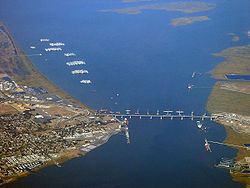
crossing (Antioch Bridge
Antioch Bridge
The Antioch Bridge crosses the San Joaquin River linking Antioch, California with Sacramento County, California. The bridge is signed as part of State Route 160. Unlike the other toll bridges in California, the Antioch bridge has only one lane going in each direction...
) between Antioch
Antioch, California
Antioch is a city in Contra Costa County, California. Located in the East Bay region of the San Francisco Bay Area along the San Joaquin-Sacramento River Delta, it is a suburb of San Francisco and Oakland. The city's population was 102,372 at the U.S...
and Oakley
Oakley, California
Oakley is a city in Contra Costa County, California, United States. The population was 35,432 at the 2010 U.S. Census. Oakley is part of the East Contra Costa Bicycle Plan, which has existing facilities in Oakley as well as plans for further expansion....
.
It is the anchorage of the ghost or mothball
Reserve fleet
A reserve fleet is a collection of naval vessels of all types that are fully equipped for service but are not currently needed, and thus partially or fully decommissioned. A reserve fleet is informally said to be "in mothballs" or "mothballed"; an equivalent expression in unofficial modern U.S....
fleet, a collection of U.S. Navy and merchant reserve ships
National Defense Reserve Fleet
The National Defense Reserve Fleet consists of "mothballed" ships, mostly merchant vessels, that can be activated within 20 to 120 days to provide shipping for the United States of America during national emergencies, either military or non-military, such as commercial shipping crises.The NDRF is...
. It was created in the period following World War II
World War II
World War II, or the Second World War , was a global conflict lasting from 1939 to 1945, involving most of the world's nations—including all of the great powers—eventually forming two opposing military alliances: the Allies and the Axis...
. Many ships were removed and sold for scrap in the 1990s, but 80 ships remain, including the WWII battleship . In 2010, plans were announced to remove the mothball fleet in stages, with final removal by 2017.
The Glomar Explorer
USNS Glomar Explorer (T-AG-193)
GSF Explorer, formerly USNS Glomar Explorer , is a deep-sea drillship platform initially built for the United States Central Intelligence Agency Special Activities Division secret operation Project Azorian to recover the sunken Soviet submarine, K-129, lost in April 1968.The cultural impact of...
was anchored here after recovering a sunken Soviet submarine (See Project Azorian).
The Central Pacific Railroad
Central Pacific Railroad
The Central Pacific Railroad is the former name of the railroad network built between California and Utah, USA that formed part of the "First Transcontinental Railroad" in North America. It is now part of the Union Pacific Railroad. Many 19th century national proposals to build a transcontinental...
built a train ferry that operated between Benicia and Port Costa, California
Port Costa, California
Port Costa is a census-designated place in Contra Costa County, California, United States. The population was 190 at the 2010 census.-Geography:...
from 1879 to 1930. The ferry boats Solano and Contra Costa were removed from service when the nearby Martinez railroad bridge was completed in 1930. From 1913 until 1954 the Sacramento Northern Railway
Sacramento Northern Railway
←The Sacramento Northern Railway was originally a electric interurban railway linking Chico in northern California to the California capitol of Sacramento The original name of the line was the Chico Electric Railway, or CERY. CERY was sold after a few months of operation to the Northern Electric...
, an electrified interurban
Interurban
An interurban, also called a radial railway in parts of Canada, is a type of electric passenger railroad; in short a hybrid between tram and train. Interurbans enjoyed widespread popularity in the first three decades of the twentieth century in North America. Until the early 1920s, most roads were...
line, crossed Suisun Bay with the Ramon, a distillate-powered train ferry
Train ferry
A train ferry is a ship designed to carry railway vehicles. Typically, one level of the ship is fitted with railway tracks, and the vessel has a door at the front and/or rear to give access to the wharves. In the United States, train ferries are sometimes referred to as "car ferries", as...
.
On April 28, 2004, a petroleum pipeline operated by Kinder Morgan Energy Partners ruptured, spilling 1,500 barrels (264m³) of diesel fuel in the marshes. Kinder Morgan pleaded guilty and paid three million dollars in penalties and restitution.

