
Humboldt Bay
Encyclopedia
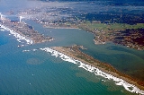
Humboldt Bay is a natural bay and a multi-basin, bar-built coastal lagoon located on the rugged North Coast
of California
, United States
entirely within Humboldt County
. The regional center and county seat of Eureka
and the college town of Arcata
adjoin the bay, which is the second largest enclosed bay in California. In addition to being a seasonal or permanent home to more than 200 bird species and 100 species of fish, the second largest estuary in California is the site of the largest commercial oyster production operation in the state. Harbor facilities include large industrial docks at Samoa
and Fields Landing and several marinas located in Eureka which are capable of serving hundreds of small to mid-size boats and pleasure craft. Since the 1850s port facilities were used to export forest and lumber products as part of the historic West coast lumber trade
, with infrequent shipping occurring to this day.
manages day to day operations and concerns related to the bay. Pilots trained and employed by the District are the only persons authorized to bring vessels beyond a certain size into the bay unless the ship's pilot has proper certification. The addition of dolosse in the 1980s strengthened the jetties, reducing the need for constant maintenance by the US Army Corps of Engineers. However, the Corps still dredges shipping channels to depths of 35–40 feet, and the harbor entrance remains challenging.
attempted to find an overland route to the Pacific ocean. They left from the gold town of Weaverville
for the 150 mile trek to the sea. Because of the density of the redwood forests and because Gregg stopped frequently to measure latitude
and the size of the trees the expedition averaged only two miles a day. The party was near starvation when they emerged on the coast where they discovered what is now known as Humboldt Bay. After stocking up on food the party walked to San Francisco to report their discovery of the bay. In March 1850 two ships, the General Morgan and the Laura Virginia, were sent to the bay from San Francisco. After considerable initial difficulty due to waves breaking heavily over shifting sands of the bar crossing, the ships entered the bay. The sailors from the Laura Virginia named the bay after Alexander von Humboldt
, a famous German naturalist
.
and Coos Bay
, Oregon
and the Port of Humboldt Bay is the only protected deep water port for large ocean-going vessels for the large region. Despite being the only protected harbor
along the approximately six hundred miles of coastline, the bay's location was undiscovered or at least unreliably charted for centuries after the first arrival of European explorers to the Pacific Coast. This is partially because it is extremely difficult to see from the ocean. The harbor opens to the sea through a narrow and historically treacherous passage, which was blocked from direct view due to sandbars now managed by jetties. Contributing to its isolation was the coastal mountain range which extends from the ocean approximately one hundred and fifty miles inland.
In the central, most narrow portion of the bay (due north of Eureka), there are three islands: Indian Island
, Woodley Island, and Daby Island.
Indian Island
previously known as Gunther's Island is the site of National Historic Landmark #67. This is an archaeological dig and one of the sites of the 1860 Wiyot Massacre
.
. Features that were lagoonal in nature, including possible occasional seasonal closure of the entrance Bar crossing, already interrupted by European settlers, began experiencing direct management and change. By 1881 the Army Corps of Engineers began dredging bay channels and, subsequently, in 1889 altering and dredging the harbor entrance.
. The Humboldt Botanical Garden
is now under construction near the Bay, with the intent of preserving its native plants.
Unfortunately, most of the dunes in Humboldt Bay are home to Ammophila arenaria
, a non-native beach grass. The California Conservation Corps
, with the Bureau of Land Management
, work year-round to combat this invasive species.
The bay is a source of subsistence and sport fishing
for a variety of salt-water fish, crustaceans, and mollusks. Dungeness Crab
are fished commercially, and oysters are commercially farmed in the bay.
The bay itself has been invaded by the European Green Crab, a voracious predator that is known to prey on the young of native crab species, as well as native mussels, oysters, and clams. European Green Crab were first documented in Humboldt Bay in 1995, and have been blamed for a decline in clam harvesting.
around the bay estuary; most of these are unincorporated suburbs of the City of Eureka.
Settlements located on or near the bay, listed clockwise from the north side of the bay entrance:
areas east of the bay (draining 250 square miles) are in bold.
North Coast, California
The North Coast of California is a region which commonly includes Marin, Sonoma, Mendocino, Humboldt, and Del Norte counties...
of California
California
California is a state located on the West Coast of the United States. It is by far the most populous U.S. state, and the third-largest by land area...
, United States
United States
The United States of America is a federal constitutional republic comprising fifty states and a federal district...
entirely within Humboldt County
Humboldt County, California
Humboldt County is a county in the U.S. state of California, located on the far North Coast 200 miles north of San Francisco. According to 2010 Census Data, the county’s population was 134,623...
. The regional center and county seat of Eureka
Eureka, California
Eureka is the principal city and the county seat of Humboldt County, California, United States. Its population was 27,191 at the 2010 census, up from 26,128 at the 2000 census....
and the college town of Arcata
Arcata, California
-Demographics:-2010 Census data:The 2010 United States Census reported that Arcata had a population of 17,231. The population density was 1,567.4 people per square mile...
adjoin the bay, which is the second largest enclosed bay in California. In addition to being a seasonal or permanent home to more than 200 bird species and 100 species of fish, the second largest estuary in California is the site of the largest commercial oyster production operation in the state. Harbor facilities include large industrial docks at Samoa
Samoa, California
Samoa is a census-designated place in Humboldt County, California. It is located northwest of Eureka, at an elevation of 23 feet . Samoa is located in the northern peninsula of Humboldt Bay and is the site of the Samoa Cookhouse, one of the last remaining original, lumber style cookhouses...
and Fields Landing and several marinas located in Eureka which are capable of serving hundreds of small to mid-size boats and pleasure craft. Since the 1850s port facilities were used to export forest and lumber products as part of the historic West coast lumber trade
West coast lumber trade
The West Coast lumber trade was a maritime trade route on the West Coast of the United States. It carried lumber from the coasts of Washington, Oregon, and Northern and Central California mainly to the port of San Francisco.-Lumber schooners:...
, with infrequent shipping occurring to this day.
Harbor management
Humboldt Bay Harbor Recreation & Conservation DistrictHumboldt Bay Harbor Recreation & Conservation District
The Humboldt Bay Harbor Recreation & Conservation District, created in 1972 by local voters, manages the Port of Humboldt Bay, and the Port of Eureka, the primary city of the region, and much larger facilities on the shore of the adjacent peninsula, known as Samoa...
manages day to day operations and concerns related to the bay. Pilots trained and employed by the District are the only persons authorized to bring vessels beyond a certain size into the bay unless the ship's pilot has proper certification. The addition of dolosse in the 1980s strengthened the jetties, reducing the need for constant maintenance by the US Army Corps of Engineers. However, the Corps still dredges shipping channels to depths of 35–40 feet, and the harbor entrance remains challenging.
History
In 1849, an expedition of seven men led by Josiah GreggJosiah Gregg
Josiah Gregg was a merchant, explorer, naturalist, and author of the American Southwest and Northern Mexico regions. He is most famous for his book Commerce of the Prairies.-Early years:...
attempted to find an overland route to the Pacific ocean. They left from the gold town of Weaverville
Weaverville, California
Weaverville is a census-designated place and the county seat of Trinity County, California. The population was 3,600 at the 2010 census, up from 3,554 at the 2000 census.-History:Founded in 1850, Weaverville is a historic California Gold Rush town...
for the 150 mile trek to the sea. Because of the density of the redwood forests and because Gregg stopped frequently to measure latitude
Latitude
In geography, the latitude of a location on the Earth is the angular distance of that location south or north of the Equator. The latitude is an angle, and is usually measured in degrees . The equator has a latitude of 0°, the North pole has a latitude of 90° north , and the South pole has a...
and the size of the trees the expedition averaged only two miles a day. The party was near starvation when they emerged on the coast where they discovered what is now known as Humboldt Bay. After stocking up on food the party walked to San Francisco to report their discovery of the bay. In March 1850 two ships, the General Morgan and the Laura Virginia, were sent to the bay from San Francisco. After considerable initial difficulty due to waves breaking heavily over shifting sands of the bar crossing, the ships entered the bay. The sailors from the Laura Virginia named the bay after Alexander von Humboldt
Alexander von Humboldt
Friedrich Wilhelm Heinrich Alexander Freiherr von Humboldt was a German naturalist and explorer, and the younger brother of the Prussian minister, philosopher and linguist Wilhelm von Humboldt...
, a famous German naturalist
Natural history
Natural history is the scientific research of plants or animals, leaning more towards observational rather than experimental methods of study, and encompasses more research published in magazines than in academic journals. Grouped among the natural sciences, natural history is the systematic study...
.
Geography
Humboldt Bay is the only deep water bay between the San Francisco BaySan Francisco Bay
San Francisco Bay is a shallow, productive estuary through which water draining from approximately forty percent of California, flowing in the Sacramento and San Joaquin rivers from the Sierra Nevada mountains, enters the Pacific Ocean...
and Coos Bay
Coos Bay
Coos Bay is an S-shaped inlet where the Coos River enters the Pacific Ocean, approximately 10 miles long and two miles wide, on the Pacific Ocean coast of southwestern Oregon in the United States. The estuary is situated south of the Salmon River. The city of Coos Bay, once named Marshfield, was...
, Oregon
Oregon
Oregon is a state in the Pacific Northwest region of the United States. It is located on the Pacific coast, with Washington to the north, California to the south, Nevada on the southeast and Idaho to the east. The Columbia and Snake rivers delineate much of Oregon's northern and eastern...
and the Port of Humboldt Bay is the only protected deep water port for large ocean-going vessels for the large region. Despite being the only protected harbor
Harbor
A harbor or harbour , or haven, is a place where ships, boats, and barges can seek shelter from stormy weather, or else are stored for future use. Harbors can be natural or artificial...
along the approximately six hundred miles of coastline, the bay's location was undiscovered or at least unreliably charted for centuries after the first arrival of European explorers to the Pacific Coast. This is partially because it is extremely difficult to see from the ocean. The harbor opens to the sea through a narrow and historically treacherous passage, which was blocked from direct view due to sandbars now managed by jetties. Contributing to its isolation was the coastal mountain range which extends from the ocean approximately one hundred and fifty miles inland.
In the central, most narrow portion of the bay (due north of Eureka), there are three islands: Indian Island
Indian Island (Humboldt Bay)
Indian Island or Duluwat Island is located on Humboldt Bay within the City of Eureka, California. The village of Tolowot or Tuluwat on Duluwat Island was the site of the spiritual if not political center of the Wiyot people and is where the main thrust of the 1860 Wiyot Massacre by European...
, Woodley Island, and Daby Island.
Indian Island
Indian Island (Humboldt Bay)
Indian Island or Duluwat Island is located on Humboldt Bay within the City of Eureka, California. The village of Tolowot or Tuluwat on Duluwat Island was the site of the spiritual if not political center of the Wiyot people and is where the main thrust of the 1860 Wiyot Massacre by European...
previously known as Gunther's Island is the site of National Historic Landmark #67. This is an archaeological dig and one of the sites of the 1860 Wiyot Massacre
1860 Wiyot Massacre
The Wiyot Massacre refers to the incidents on February 26, 1860, at Tuluwat on what is now known as Indian Island, near Eureka in Humboldt County, California.-Event:...
.
Geomorphology
Previous to settlement, and perhaps for years after, the bay was a stable tidal lagoon (in its natural state) despite significant tectonic activity, primarily due to its location in proximity to the Cascadia subduction zoneCascadia subduction zone
The Cascadia subduction zone is a subduction zone, a type of convergent plate boundary that stretches from northern Vancouver Island to northern California. It is a very long sloping fault that separates the Juan de Fuca and North America plates.New ocean floor is being created offshore of...
. Features that were lagoonal in nature, including possible occasional seasonal closure of the entrance Bar crossing, already interrupted by European settlers, began experiencing direct management and change. By 1881 the Army Corps of Engineers began dredging bay channels and, subsequently, in 1889 altering and dredging the harbor entrance.
Environment
Humboldt Bay and its tidal sloughs are open to fishing year-round, and the bay is home to a national wildlife refuge complex for the protection of wetlands and bay habitats for migratory birds. In the winter it is not unusual for the bay to serve as a feeding and resting site for more than one hundred thousand birds. Humboldt Bay is recognized for protection by the California Bays and Estuaries PolicyCalifornia Bays and Estuaries Policy
The Water Quality Control Policy for the Enclosed Bays and Estuaries of California is published by the California State Water Resources Control Board as guidelines to prevent water quality degradation. The policy is revised as needed.-Geography:...
. The Humboldt Botanical Garden
Humboldt Botanical Garden
The Humboldt Botanical Gardens are under construction south of Eureka, California, USA near the Humboldt Bay at the College of the Redwoods. Grading and site preparation for the Gardens began in August 2003, and...
is now under construction near the Bay, with the intent of preserving its native plants.
Unfortunately, most of the dunes in Humboldt Bay are home to Ammophila arenaria
Ammophila arenaria
Ammophila arenaria is a species of grass known by the common names European Marram Grass and European Beachgrass. It is one of two species of the genus Ammophila . It is native to the coastlines of Europe and North Africa where it grows in the sands of beach dunes. It is a perennial grass forming...
, a non-native beach grass. The California Conservation Corps
California Conservation Corps
The California Conservation Corps, or the CCC, is a department of the government of California, falling under the state cabinet-level California Resources Agency...
, with the Bureau of Land Management
Bureau of Land Management
The Bureau of Land Management is an agency within the United States Department of the Interior which administers America's public lands, totaling approximately , or one-eighth of the landmass of the country. The BLM also manages of subsurface mineral estate underlying federal, state and private...
, work year-round to combat this invasive species.
The bay is a source of subsistence and sport fishing
Fishing
Fishing is the activity of trying to catch wild fish. Fish are normally caught in the wild. Techniques for catching fish include hand gathering, spearing, netting, angling and trapping....
for a variety of salt-water fish, crustaceans, and mollusks. Dungeness Crab
Dungeness crab
The Dungeness crab, Metacarcinus magister , is a species of crab that inhabits eelgrass beds and water bottoms on the west coast of North America. It typically grows to across the carapace and is a popular seafood...
are fished commercially, and oysters are commercially farmed in the bay.
The bay itself has been invaded by the European Green Crab, a voracious predator that is known to prey on the young of native crab species, as well as native mussels, oysters, and clams. European Green Crab were first documented in Humboldt Bay in 1995, and have been blamed for a decline in clam harvesting.
Bay settlements
About 80,000 people reside on the shore of the bay, the largest Pacific coastal population center north of San Francisco in the contiguous United States (as neither Portland nor Seattle are located oceanside on the Pacific Coast). There are at least 20 named settlements on the coastal plainCoastal plain
A coastal plain is an area of flat, low-lying land adjacent to a seacoast and separated from the interior by other features. One of the world's longest coastal plains is located in eastern South America. The southwestern coastal plain of North America is notable for its species diversity...
around the bay estuary; most of these are unincorporated suburbs of the City of Eureka.
Settlements located on or near the bay, listed clockwise from the north side of the bay entrance:
- FairhavenFairhaven, CaliforniaFairhaven is an unincorporated community in Humboldt County, California. It is located west-southwest of downtown Eureka, at an elevation of 10 feet ....
- SamoaSamoa, CaliforniaSamoa is a census-designated place in Humboldt County, California. It is located northwest of Eureka, at an elevation of 23 feet . Samoa is located in the northern peninsula of Humboldt Bay and is the site of the Samoa Cookhouse, one of the last remaining original, lumber style cookhouses...
- ManilaManila, CaliforniaManila is a census-designated place in Humboldt County, California. It is located north of downtown Eureka, at an elevation of 13 feet . The ZIP Code is 95521...
- ArcataArcata, California-Demographics:-2010 Census data:The 2010 United States Census reported that Arcata had a population of 17,231. The population density was 1,567.4 people per square mile...
- Sunny BraeSunny Brae, CaliforniaSunny Brae is an unincorporated community in Humboldt County, California. It is located southeast of downtown Arcata, at an elevation of 52 feet . This neighborhood, primarily built of tract homes in the 1950's and 1960's is considered part of Arcata....
- BaysideBayside, CaliforniaBayside is an unincorporated community in Humboldt County, California. It is located south-southeast of Arcata, at an elevation of 33 feet . The ZIP Code is 95524....
- Jacoby Creek
- Sunny Brae
- EurekaEureka, CaliforniaEureka is the principal city and the county seat of Humboldt County, California, United States. Its population was 27,191 at the 2010 census, up from 26,128 at the 2000 census....
- Indianola (includes Hidden Valley)
- FreshwaterFreshwater, Humboldt County, CaliforniaFreshwater is an unincorporated community in Humboldt County, California. It is located on Freshwater Creek, a major tributary to Humboldt Bay , south of Arcata, at an elevation of 92 feet...
- MyrtletownMyrtletown, CaliforniaMyrtletown is a census-designated place in Humboldt County, California, United States. Myrtletown lies at an elevation of 112 feet . Myrtletown is a part of the Eureka, California metropolitan area...
- CuttenCutten, CaliforniaCutten is a census-designated place in Humboldt County, California, United States. Cutten is located south-southeast of downtown Eureka, at an elevation of 200 feet...
- Ridgewood
- Pine HillPine Hill, CaliforniaPine Hill is an unincorporated community in Humboldt County, California. It is located south of downtown Eureka, at an elevation of 135 feet . The area is now part of unincorporated Eureka.The name honors Safford E. Pine, local dairy farmer....
- Bayview
- Elk RiverElk River, CaliforniaElk River is an unincorporated community in Humboldt County, California. It is located east-northeast of Fields Landing, at an elevation of 69 feet . All the residents of this neighborhood have Eureka, California addresses....
- Humboldt HillHumboldt Hill, CaliforniaHumboldt Hill is a census-designated place in Humboldt County, California, United States. Humboldt Hill lies at an elevation of 194 feet . The population was 3,414 at the 2010 census, up from 3,246 at the 2000 census...
- King SalmonKing Salmon, CaliforniaKing Salmon is an unincorporated community in Humboldt County, California, United States. The small fishing enclave, which has a Eureka zipcode , is nonetheless part of Greater Eureka. It is also the site of the Humboldt Bay Power Plant...
- Fields LandingFields Landing, CaliforniaFields Landing is a census-designated place in Humboldt County, California. It is located on Humboldt Bay south-southwest of downtown Eureka, at an elevation of 13 feet . The ZIP Code is 95537...
- HooktonHookton, CaliforniaHookton is an locality in Humboldt County, California. It is located south of Fields Landing, at an elevation of .Hookton is named for its founder, John Hookton....
Bay tributaries and sloughs
Streams and sloughs that enter into Humboldt Bay are listed north to south (in a clockwise fashion) with tributaries entering nearest the bay listed first. The primary streams of major watershedDrainage basin
A drainage basin is an extent or an area of land where surface water from rain and melting snow or ice converges to a single point, usually the exit of the basin, where the waters join another waterbody, such as a river, lake, reservoir, estuary, wetland, sea, or ocean...
areas east of the bay (draining 250 square miles) are in bold.
- Mad River Slough
- Liscom Slough
- Janes Creek (enters the bay as McDaniels Slough)
- Jolly Giant Creek (enters the bay as Butcher Slough)
- Campbell Creek (partially channeled to Gannon Slough)
- Fickle Hill Creek
- Gannon Slough
- Grotzman Creek
- Beith Creek
- Little Jacoby Creek
- Jacoby Creek
- Washington Gulch Creek
- Rocky Gulch Creek
- Eureka Slough
- Fay Slough
- Cochran Creek
- Freshwater Creek
- Little Freshwater Creek
- Ryan Slough
- Ryan Creek
- First Slough
- Second Slough
- Third Slough
- Fay Slough
- Clarke Slough
- Elk River (California)
- Swain Slough
- Martin Slough
- Swain Slough
- Willow Brook/White Slough
- Salmon Creek (Northern Humboldt County)
- Deering Creek
- Little Salmon Creek
- Hookton Slough
See also
- California State Route 255California State Route 255State Route 255 is a state highway in Humboldt County, California, United States.-Route description:It is a western alternate route of U.S. Route 101 between Eureka and Arcata, routed via the three bridges over Humboldt Bay and Indian Island and Woodley Islands, rather than motorists having to...
– only bay crossing and sole access to Eureka's Woodley Island Marina. - Humboldt Harbor LightHumboldt Harbor LightThe Humboldt Harbor Light was an early lighthouse marking the entrance to Humboldt Bay. Plagued by fog, earthquakes, and flooding, it was eventually abandoned in favor of a new light at Table Bluff.-History:...
- Table Bluff LightTable Bluff LightTable Bluff Lighthouse is a lighthouse in California,United States, on southern Humboldt Bay, near Eureka, California. The Table Bluff Lighthouse was one of the first to be automated. The light house tower portion is now located at the Woodley Island Marina within the City of Eureka.-History:Table...