
.gif)
El Camino Real (California)
Encyclopedia
Alta California
Alta California was a province and territory in the Viceroyalty of New Spain and later a territory and department in independent Mexico. The territory was created in 1769 out of the northern part of the former province of Las Californias, and consisted of the modern American states of California,...
's 21 missions
Spanish missions in California
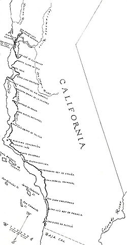
The Spanish missions in California comprise a series of religious and military outposts established by Spanish Catholics of the Franciscan Order between 1769 and 1823 to spread the Christian faith among the local Native Americans. The missions represented the first major effort by Europeans to...
(along with a number of support sites), 4 presidio
Presidio
A presidio is a fortified base established by the Spanish in North America between the sixteenth and nineteenth centuries. The fortresses were built to protect against pirates, hostile native Americans and enemy colonists. Other presidios were held by Spain in the sixteenth and seventeenth...
s, and several pueblo
Pueblo
Pueblo is a term used to describe modern communities of Native Americans in the Southwestern United States of America. The first Spanish explorers of the Southwest used this term to describe the communities housed in apartment-like structures built of stone, adobe mud, and other local material...
s, stretching from Mission San Diego de Alcalá
Mission San Diego de Alcalá
Mission Basilica San Diego de Alcalá, in San Diego, California, was the first Franciscan mission in the Las Californias Province of the Viceroyalty of New Spain. It was founded in 1769 by Spanish friar Junípero Serra in an area long inhabited by the Kumeyaay Indians...
in San Diego
San Diego, California
San Diego is the eighth-largest city in the United States and second-largest city in California. The city is located on the coast of the Pacific Ocean in Southern California, immediately adjacent to the Mexican border. The birthplace of California, San Diego is known for its mild year-round...
in the south to Mission San Francisco Solano
Mission San Francisco Solano
Mission San Francisco Solano was founded on July 4, 1823, and named for Francis Solanus, a missionary to the Indians of Peru born in Montilla, Spain, known as the "Wonder Worker of the New World." Originally planned as an asistencia to Mission San Rafael Arcángel, it is the northernmost Alta...
in Sonoma
Sonoma, California
Sonoma is a historically significant city in Sonoma Valley, Sonoma County, California, USA, surrounding its historic town plaza, a remnant of the town's Mexican colonial past. It was the capital of the short-lived California Republic...
in the north.
In fact, any road under the direct jurisdiction of the Spanish crown and its viceroys was a "camino real." Examples of such roads ran between principal settlements throughout Spain
Spain
Spain , officially the Kingdom of Spain languages]] under the European Charter for Regional or Minority Languages. In each of these, Spain's official name is as follows:;;;;;;), is a country and member state of the European Union located in southwestern Europe on the Iberian Peninsula...
and its colonies such as New Spain
New Spain
New Spain, formally called the Viceroyalty of New Spain , was a viceroyalty of the Spanish colonial empire, comprising primarily territories in what was known then as 'América Septentrional' or North America. Its capital was Mexico City, formerly Tenochtitlan, capital of the Aztec Empire...
. Most caminos reales had names apart from the appended "camino real". Once Mexico
Mexico
The United Mexican States , commonly known as Mexico , is a federal constitutional republic in North America. It is bordered on the north by the United States; on the south and west by the Pacific Ocean; on the southeast by Guatemala, Belize, and the Caribbean Sea; and on the east by the Gulf of...
won its independence from Spain, no road in Mexico, including California
California
California is a state located on the West Coast of the United States. It is by far the most populous U.S. state, and the third-largest by land area...
, was a camino real. The name was rarely used after that and was only revived in the American period
History of the United States
The history of the United States traditionally starts with the Declaration of Independence in the year 1776, although its territory was inhabited by Native Americans since prehistoric times and then by European colonists who followed the voyages of Christopher Columbus starting in 1492. The...
in connection with the boosterism associated with the Mission Revival movement
Mission Revival Style architecture
The Mission Revival Style was an architectural movement that began in the late 19th century for a colonial style's revivalism and reinterpretation, which drew inspiration from the late 18th and early 19th century Spanish missions in California....
of the early 20th century.
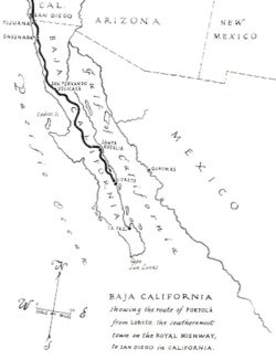
The route originated in Baja California Sur
Baja California Sur
Baja California Sur , is one of the 31 states which, with the Federal District, comprise the 32 Federal Entities of Mexico. Before becoming a state on October 8, 1974, the area was known as the South Territory of Baja California. It has an area of , or 3.57% of the land mass of Mexico and comprises...
, Mexico
Mexico
The United Mexican States , commonly known as Mexico , is a federal constitutional republic in North America. It is bordered on the north by the United States; on the south and west by the Pacific Ocean; on the southeast by Guatemala, Belize, and the Caribbean Sea; and on the east by the Gulf of...
, at the site of Misión San Bruno
Misión San Bruno
The short-lived Jesuit mission of San Bruno was established in 1683 on the Gulf of California of Baja California Sur, about 20 kilometers north of the later site of the town of Loreto....
in San Bruno
San Bruno, Baja California Sur
San Bruno is a populated place at the Gulf of California in Mulegé Municipality in the Mexican state of Baja California Sur. It is located at , about 20 kilometers north of the city of Mulegé. The short-lived Jesuit Misión San Bruno was established there in 1683, and abandoned in 1685...
(the first mission established in Las Californias
Las Californias
The Californias, or in — - was the name given by the Spanish to their northwestern territory of New Spain, comprising the present day states of Baja California and Baja California Sur on the Baja California Peninsula in Mexico; and the present day U.S. state of California in the United States of...
), though it was only maintained as far south as Loreto
Loreto, Baja California Sur
Loreto was the first Spanish settlement on the Baja California Peninsula. It served as the capital of Las Californias from 1697 to 1777, and is the current seat of the municipality of Loreto in the Mexican state of Baja California Sur...
.
History
Spain
Spain , officially the Kingdom of Spain languages]] under the European Charter for Regional or Minority Languages. In each of these, Spain's official name is as follows:;;;;;;), is a country and member state of the European Union located in southwestern Europe on the Iberian Peninsula...
missionaries
Missionary
A missionary is a member of a religious group sent into an area to do evangelism or ministries of service, such as education, literacy, social justice, health care and economic development. The word "mission" originates from 1598 when the Jesuits sent members abroad, derived from the Latin...
established a series of religious outposts throughout the present-day California
California
California is a state located on the West Coast of the United States. It is by far the most populous U.S. state, and the third-largest by land area...
and the present-day Baja California
Baja California
Baja California officially Estado Libre y Soberano de Baja California is one of the 31 states which, with the Federal District, comprise the 32 Federal Entities of Mexico. It is both the northernmost and westernmost state of Mexico. Before becoming a state in 1953, the area was known as the North...
and Baja California Sur
Baja California Sur
Baja California Sur , is one of the 31 states which, with the Federal District, comprise the 32 Federal Entities of Mexico. Before becoming a state on October 8, 1974, the area was known as the South Territory of Baja California. It has an area of , or 3.57% of the land mass of Mexico and comprises...
. To facilitate overland travel, mission settlements were approximately 30 miles (48 kilometers) apart, so that they were separated by one long day's ride on horseback along the 600-mile (966-kilometer) long El Camino Real (Spanish
Spanish language
Spanish , also known as Castilian , is a Romance language in the Ibero-Romance group that evolved from several languages and dialects in central-northern Iberia around the 9th century and gradually spread with the expansion of the Kingdom of Castile into central and southern Iberia during the...
for "The Royal Highway," though often referred to in the later embellished English translation, "The King's Highway"), and also known as the California Mission Trail. Heavy freight movement was practical only via water. Tradition has it that the padres sprinkled mustard
Mustard plant
Mustards are several plant species in the genera Brassica and Sinapis whose small mustard seeds are used as a spice and, by grinding and mixing them with water, vinegar or other liquids, are turned into the condiment known as mustard or prepared mustard...
seeds along the trail in order to mark it with bright yellow flowers.
In 1912, California began paving a section of the historic route in San Mateo County. Construction of a two-lane concrete highway began in front of the historic Uncle Tom's Cabin, an inn in San Bruno that was built in 1849 and demolished exactly 100 years later. There was little traffic initially and children used the pavement for roller skating until traffic increased. By the late 1920s, California began the first of numerous widening projects of what later became part of U.S. Route 101. Today the route through San Mateo and Santa Clara counties is designated as State Route 82.
An unpaved portion of the original Spanish road has been preserved just east of Mission San Juan Bautista
Mission San Juan Bautista
Mission San Juan Bautista was founded on June 24, 1797 in what is now the San Juan Bautista Historic District of San Juan Bautista, California. Barracks for the soldiers, a nunnery, the Jose Castro House, and other buildings were constructed around a large grassy plaza in front of the church and...
in San Juan Bautista, California
San Juan Bautista, California
San Juan Bautista is a city in San Benito County, California, United States. The population was 1,862 at the 2010 census, up from 1,549 at the 2000 census. The city of San Juan Bautista was named after Mission San Juan Bautista...
.
The road today
Today, several modern highways cover parts of the historic route, though large sections are on city streets (for instance, most of the stretch between San Jose and San Francisco). Its full modern route, as defined by the California State LegislatureCalifornia State Legislature
The California State Legislature is the state legislature of the U.S. state of California. It is a bicameral body consisting of the lower house, the California State Assembly, with 80 members, and the upper house, the California State Senate, with 40 members...
, is as follows:
- Interstate 5Interstate 5 in CaliforniaInterstate 5 is a major north–south route of the Interstate Highway System in the U.S. state of California. It begins at the Mexico – United States border at the San Ysidro crossing, goes north across the length of California and crosses into Oregon south of the Medford-Ashland metropolitan...
, U.S.-Mexico border to Anaheim - Anaheim Boulevard, Harbor BoulevardHarbor BoulevardHarbor Boulevard is a major thoroughfare in central Orange County.-Route description:It runs from Costa Mesa through Santa Ana, Garden Grove, Anaheim and La Habra before it turns into Fullerton Road in the unincorporated community of Rowland Heights just over the Los Angeles County line...
, State Route 72 and Whittier Boulevard, Anaheim to Los Angeles - U.S. Route 101, Los AngelesLos ÁngelesLos Ángeles is the capital of the province of Biobío, in the commune of the same name, in Region VIII , in the center-south of Chile. It is located between the Laja and Biobío rivers. The population is 123,445 inhabitants...
to San Jose - State Route 82California State Route 82State Route 82 is a state highway in the U.S. state of California that runs from U.S. Route 101 at Blossom Hill Road in San Jose to Interstate 280 in San Francisco following the San Francisco Peninsula...
, San Jose to San Francisco - Interstate 280Interstate 280 (California)Interstate 280 is a 57-mile long north–south Interstate Highway in the San Francisco Bay Area of Northern California. It connects San Jose and San Francisco, running along just to the west of the cities of San Francisco Peninsula for most of its route.I-280 from its northern end at King...
, San Francisco - U.S. Route 101, San Francisco to Novato
- State Route 37, Novato to Sears Point
- State Route 121, Sears Point to Sonoma
- State Route 12State Route 12 (California)State Route 12 is a state highway in the U.S. state of California that travels in an east–west direction from Sebastopol in Sonoma County to State Route 49 just north of San Andreas in Calaveras County...
, Sonoma
East Bay route
- State Route 87California State Route 87State Route 87 , locally called Highway 87 or the Guadalupe Freeway, is a north–south state highway entirely within San Jose, California, United States. Its name was changed from Guadalupe Parkway in 2004 after its entire constructed length was upgraded to a freeway...
, Pass through Santa Clara County and Alameda County. - State Route 92California State Route 92State Route 92 is an east-west highway in the San Francisco Bay area between Half Moon Bay near the coast in the west and downtown Hayward at its junction with State Route 238 and State Route 185. It is most notable for being the route that traverses the San Mateo Bridge. It has interchanges with...
- State Route 238California State Route 238State Route 238 is a north–south highway in the U.S. state of California. The route is a divided multilane surface highway in the southeastern part of the San Francisco Bay Area. SR 238 connects Interstate 580 in Castro Valley and Interstate 680 in Fremont.-Route description:SR 238 goes...
- State Route 185California State Route 185State Route 185 is a state highway in the San Francisco Bay Area of the U.S. state of California. It runs along sections of Mission Boulevard in Hayward, East 14th Street in San Leandro and International Boulevard in Oakland.-Route description:...
, Hayward to Oakland - State Route 123California State Route 123State Route 123 is a state highway in the U.S. state of California in the San Francisco Bay Area. Named San Pablo Avenue for virtually its entire length, SR 123 is a major north–south state highway along the flats of the urban East Bay in the U.S. state of California...
, Oakland to San Pablo (continued to Martinez)
Some older local roads that parallel these routes also have the name. Many streets throughout California
California
California is a state located on the West Coast of the United States. It is by far the most populous U.S. state, and the third-largest by land area...
today bear the name of this famous road, often with little factual relation to the original; but Mission Street
Mission Street
Mission Street is a north-south arterial thoroughfare in San Francisco, California that runs from the city's southern border to its northeast corner. The street and the Mission District through which it runs were named for the Spanish Mission Dolores, several blocks away from the modern route. Only...
in San Francisco and its counterpart in Santa Cruz
Santa Cruz, California
Santa Cruz is the county seat and largest city of Santa Cruz County, California in the US. As of the 2010 U.S. Census, Santa Cruz had a total population of 59,946...
do correspond to the historical route. A surviving, unpaved stretch of the road has been preserved next to the old Spanish mission in San Juan Bautista, California
San Juan Bautista, California
San Juan Bautista is a city in San Benito County, California, United States. The population was 1,862 at the 2010 census, up from 1,549 at the 2000 census. The city of San Juan Bautista was named after Mission San Juan Bautista...
; this road actually follows part of the San Andreas Fault
San Andreas Fault
The San Andreas Fault is a continental strike-slip fault that runs a length of roughly through California in the United States. The fault's motion is right-lateral strike-slip...
.
Bells

Pasadena, California
Pasadena is a city in Los Angeles County, California, United States. Although famous for hosting the annual Rose Bowl football game and Tournament of Roses Parade, Pasadena is the home to many scientific and cultural institutions, including the California Institute of Technology , the Jet...
initiated an effort to preserve the as-yet uncommemorated route of Alta California’s Camino Real, an effort adopted by the California Federation of Women's Clubs in 1902. Modern El Camino Real was one of the first state highways in California. Given the lack of standardized road signs at the time, it was decided to place distinctive bells along the route, hung on supports in the form of an 11 feet (3.4 m) high shepherd's crook, also described as "a Franciscan walking stick." The first of 450 bells were unveiled on August 15, 1906 at the Plaza Church in the Pueblo near Olvera Street
Olvera Street
Olvera Street is in the oldest part of Downtown Los Angeles, California, and is part of the El Pueblo de Los Angeles Historic Monument. Many Latinos refer to it as "La Placita Olvera." Circa 1911 it was described as Sonora Town....
in Los Angeles
Los Ángeles
Los Ángeles is the capital of the province of Biobío, in the commune of the same name, in Region VIII , in the center-south of Chile. It is located between the Laja and Biobío rivers. The population is 123,445 inhabitants...
.
The original organization which installed the bells fragmented, and the Automobile Club of Southern California
Automobile Club of Southern California
The Automobile Club of Southern California is the Southern California affiliate of the American Automobile Association federation of motor clubs...
and associated groups cared for the bells from the mid-1920s through 1931. The State took over bell maintenance in 1933. Most of the bells eventually disappeared due to vandalism, theft or simple loss due to the relocation or rerouting of highways and roads. After a reduction in the number of bells to around 80, the State began replacing them, at first with concrete, and later with iron. A design first produced in 1960 by Justin Kramer of Los Angeles was the standard until the California Department of Transportation (Caltrans) began a restoration effort in 1996.
Keith Robinson, Principal Landscape Architect at Caltrans developed an El Camino Real restoration program which resulted in the installation of 555 El Camino Real Bell Markers in 2005. The Bell Marker consists of a 460 mm diameter cast metal bell set atop a 75 mm diameter Schedule 40 pipe column that is attached to a concrete foundation using anchor rods. The original 1906 bell molds were used to fabricate the replacement bells. The replacement and original bells were produced by the California Bell Company
California Bell Company
The California Bell Company, a company that produces bells, was established in 1914 by Mrs. A.S.C. Forbes. The company has its headquarters in Saratoga, California. Their history goes back to 1906, when Forbes designed the first of the El Camino Real Bells....
, are dated 1769 to 1906, and include a designer's copyright notice.
Historic designations
- California Historical LandmarkCalifornia Historical LandmarkCalifornia Historical Landmarks are buildings, structures, sites, or places in the state of California that have been determined to have statewide historical significance by meeting at least one of the criteria listed below:...
#784 – El Camino Real ("as Father Serra knew it and helped blaze it" – the segment extending from Mission San Diego de AlcaláMission San Diego de AlcaláMission Basilica San Diego de Alcalá, in San Diego, California, was the first Franciscan mission in the Las Californias Province of the Viceroyalty of New Spain. It was founded in 1769 by Spanish friar Junípero Serra in an area long inhabited by the Kumeyaay Indians...
to Mission San Francisco de AsísMission San Francisco de AsísMission San Francisco de Asís, or Mission Dolores, is the oldest surviving structure in San Francisco and the sixth religious settlement established as part of the California chain of missions...
)
See also
- El Camino Real (disambiguation)
- El Camino ViejoEl Camino ViejoEl Camino Viejo à Los Angeles , also known as the Old Los Angeles Trail, established in 1820's, was the oldest north-south trail in the interior of Alta California...
- History of CaliforniaHistory of CaliforniaThe history of California can be divided into several periods: the Native American period; European exploration period from 1542 to 1769; the Spanish colonial period, 1769 to 1821; the Mexican period, 1821 to 1848; and United States statehood, which continues to the present day...
- Spanish missions in CaliforniaSpanish missions in CaliforniaThe Spanish missions in California comprise a series of religious and military outposts established by Spanish Catholics of the Franciscan Order between 1769 and 1823 to spread the Christian faith among the local Native Americans. The missions represented the first major effort by Europeans to...
- Spanish missions in Baja CaliforniaSpanish missions in Baja CaliforniaThe Spanish Missions in Baja California comprise a series of religious outposts established by Spanish Catholic religious orders, the Jesuits, the Franciscans and the Dominicans, between 1683 and 1834 to spread the Christian doctrine among the local natives...
External links
- Caltrans: El Camino Real Mission Bell Marker Project
- California Bell Company - Original and current manufacturer of the El Camino Real bells
- Trails and Roads: El Camino Real - from the California Highways site
- El Camino Real, California's Coast Route