

Fort Tejon
Encyclopedia
Fort Tejon in California
is a former United States Army
outpost which was intermittently active from June 24, 1854, until September 11, 1864. It is located in the Grapevine Canyon
(La Cañada de las Uvas) area of Tejon Pass
along Interstate 5
, the main route through the mountains separating the Central Valley from Los Angeles
. The fort's location protected the San Joaquin Valley
from the south and east.
The fort's mission was to suppress stock rustling and protect settlers from attacks by Native American
tribes, including the Paiute
and Mojave, and to monitor the less aggressive Emigdiano living nearby. The Emigdiano, who were closely related to the Chumash of the Santa Barbara
area, had several villages near Fort Tejon. They were generally cooperative with the European-American settlers and the US Army.
 At the urging of Edward Fitzgerald Beale
, Superintendent of Indian Affairs in California, the U.S. Army established Fort Tejon in 1854. Fort Tejon was the headquarters of the First U.S. Dragoons until those Regular Army troops were transferred to the East in July 1861 soon after the outbreak of the American Civil War
. The fort was re-occupied by California volunteer troops in 1863. Those units included Companies D, E and G of the 2nd California Volunteer Cavalry from July 6 to August 17, 1863; and Company B of the 2nd California Volunteer Infantry, which remained there until Fort Tejon was abandoned for good on September 11, 1864.
The fort lay along the Stockton - Los Angeles Road
. From 1858, it was a stagecoach
station on the Butterfield Overland Mail
, which followed the same route as far as Visalia
. From 1858, Fort Tejon was the western terminus of the experimental U.S. Camel Corps, which used imported camel
s in an effort to carry supplies across arid regions in the Southwest
. The soldiers found the camels hardy, but temperamental, and they spooked the horses used by the cavalry.
The great earthquake of 1857, which became known as the Fort Tejon earthquake
, was centered nearly 100 miles away. The earthquake became associated with the fort by name because the area near the epicenter
was sparsely populated. The most reliable report of the event was issued from the fort, nearly 93 miles (149.7 km) distant.
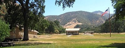
. Its original historic buildings have been documented by the Historic American Buildings Survey
. Several buildings have been restored, and two are partially open to visitors. The restored barracks contain display cases of uniforms and a recreated troopers' quarters. The commanding officer's quarters have several restored and furnished rooms. Officers' quarters nearby are only stabilized in a state of arrested decay
, with walls buttressed by masonry and lumber and tied together with reinforcing rods.
A quartermaster
building has recently been reconstructed houses materials used in Dragoon
life and Civil War reenactments. The sites of former buildings, planned for reconstruction, are marked by split rail fences along the outlines of their foundations. A park office, containing exhibits of dragoon life and restrooms, is at the east end of the parade ground near the parking lot by Interstate 5.
The park grounds include the grave site of Peter Lebeck, which is indicated with a historical marker. The nearby town of Lebec is named after him.
Fort Tejon is the site of frequent Civil War reenactments
presented by the Fort Tejon Historical Association.
for a length of about 350 kilometres (217.5 mi), between Parkfield
and San Bernardino
. Displacement along the fault was as much as 9 meters (30 feet) in the Carrizo Plain
but less along the Palmdale section of the fault, closest to Los Angeles. The amount of fault slip gives this earthquake a moment magnitude
of 7.9, comparable to that of the 1906 San Francisco earthquake
. Based on the (uncertain) distribution of foreshocks for this earthquake, it is assumed that the beginning of the fault rupture (the epicenter) was in the area between Parkfield and Cholame
, about 60 miles northwest. Nevertheless, it is usually called the "Fort Tejon" earthquake because this was the location of the greatest damage, most of the area being unpopulated at the time.
California
California is a state located on the West Coast of the United States. It is by far the most populous U.S. state, and the third-largest by land area...
is a former United States Army
United States Army
The United States Army is the main branch of the United States Armed Forces responsible for land-based military operations. It is the largest and oldest established branch of the U.S. military, and is one of seven U.S. uniformed services...
outpost which was intermittently active from June 24, 1854, until September 11, 1864. It is located in the Grapevine Canyon
Grapevine, California
Grapevine is an unincorporated community in Kern County, California. At an elevation of 1499 feet , the community is located at the foot of a road grade known as The Grapevine through the Grapevine Canyon to Tejon Pass in the Tehachapi Mountains at the southern end of the San Joaquin Valley along...
(La Cañada de las Uvas) area of Tejon Pass
Tejon Pass
The Tejon Pass is a mountain pass at the southwest end of the Tehachapi Mountains linking Southern to Central California.-Geography:The apex of the pass is near the northwesternmost corner of Los Angeles County, north of Gorman...
along Interstate 5
Interstate 5
Interstate 5 is the main Interstate Highway on the West Coast of the United States, running largely parallel to the Pacific Ocean coastline from Canada to Mexico . It serves some of the largest cities on the U.S...
, the main route through the mountains separating the Central Valley from Los Angeles
Los Ángeles
Los Ángeles is the capital of the province of Biobío, in the commune of the same name, in Region VIII , in the center-south of Chile. It is located between the Laja and Biobío rivers. The population is 123,445 inhabitants...
. The fort's location protected the San Joaquin Valley
San Joaquin Valley
The San Joaquin Valley is the area of the Central Valley of California that lies south of the Sacramento – San Joaquin River Delta in Stockton...
from the south and east.
The fort's mission was to suppress stock rustling and protect settlers from attacks by Native American
Native Americans in the United States
Native Americans in the United States are the indigenous peoples in North America within the boundaries of the present-day continental United States, parts of Alaska, and the island state of Hawaii. They are composed of numerous, distinct tribes, states, and ethnic groups, many of which survive as...
tribes, including the Paiute
Paiute
Paiute refers to three closely related groups of Native Americans — the Northern Paiute of California, Idaho, Nevada and Oregon; the Owens Valley Paiute of California and Nevada; and the Southern Paiute of Arizona, southeastern California and Nevada, and Utah.-Origin of name:The origin of...
and Mojave, and to monitor the less aggressive Emigdiano living nearby. The Emigdiano, who were closely related to the Chumash of the Santa Barbara
Santa Barbara, California
Santa Barbara is the county seat of Santa Barbara County, California, United States. Situated on an east-west trending section of coastline, the longest such section on the West Coast of the United States, the city lies between the steeply-rising Santa Ynez Mountains and the Pacific Ocean...
area, had several villages near Fort Tejon. They were generally cooperative with the European-American settlers and the US Army.
History
Edward Fitzgerald Beale
Edward Fitzgerald "Ned" Beale was a national figure in 19th century America. He was naval officer, military general, explorer, frontiersman, Indian affairs superintendent, California rancher, diplomat, and friend of Kit Carson, Buffalo Bill Cody and Ulysses S. Grant...
, Superintendent of Indian Affairs in California, the U.S. Army established Fort Tejon in 1854. Fort Tejon was the headquarters of the First U.S. Dragoons until those Regular Army troops were transferred to the East in July 1861 soon after the outbreak of the American Civil War
American Civil War
The American Civil War was a civil war fought in the United States of America. In response to the election of Abraham Lincoln as President of the United States, 11 southern slave states declared their secession from the United States and formed the Confederate States of America ; the other 25...
. The fort was re-occupied by California volunteer troops in 1863. Those units included Companies D, E and G of the 2nd California Volunteer Cavalry from July 6 to August 17, 1863; and Company B of the 2nd California Volunteer Infantry, which remained there until Fort Tejon was abandoned for good on September 11, 1864.
The fort lay along the Stockton - Los Angeles Road
Stockton - Los Angeles Road
Stockton-Los Angeles Road, also known as the Millerton Road, Stockton-Mariposa Road, Stockton-Fort Miller Road or the Stockton-Visalia Road was established about 1853 following the discovery of gold on the Kern River in Old Tulare County...
. From 1858, it was a stagecoach
Stagecoach
A stagecoach is a type of covered wagon for passengers and goods, strongly sprung and drawn by four horses, usually four-in-hand. Widely used before the introduction of railway transport, it made regular trips between stages or stations, which were places of rest provided for stagecoach travelers...
station on the Butterfield Overland Mail
Butterfield Overland Mail
The Butterfield Overland Mail Trail was a stagecoach route in the United States, operating from 1857 to 1861. It was a conduit for the U.S. mail from two eastern termini, Memphis, Tennessee and St. Louis, Missouri, meeting Fort Smith, Arkansas, and continuing through Indian Territory, New Mexico,...
, which followed the same route as far as Visalia
Visalia, California
Visalia is a Central California city situated in the heart of California’s agricultural San Joaquin Valley, approximately southeast of San Francisco and north of Los Angeles...
. From 1858, Fort Tejon was the western terminus of the experimental U.S. Camel Corps, which used imported camel
Camel
A camel is an even-toed ungulate within the genus Camelus, bearing distinctive fatty deposits known as humps on its back. There are two species of camels: the dromedary or Arabian camel has a single hump, and the bactrian has two humps. Dromedaries are native to the dry desert areas of West Asia,...
s in an effort to carry supplies across arid regions in the Southwest
Southwestern United States
The Southwestern United States is a region defined in different ways by different sources. Broad definitions include nearly a quarter of the United States, including Arizona, California, Colorado, Nevada, New Mexico, Oklahoma, Texas and Utah...
. The soldiers found the camels hardy, but temperamental, and they spooked the horses used by the cavalry.
The great earthquake of 1857, which became known as the Fort Tejon earthquake
Fort Tejon earthquake
The Fort Tejon earthquake occurred at about 8:20 AM on January 9, 1857. It ruptured the San Andreas Fault for a length of about 225 miles , between Parkfield and Wrightwood. The average slip along the fault was 4.5 meters , and a maximum offset of 9 meters was recorded in the Carrizo Plain area...
, was centered nearly 100 miles away. The earthquake became associated with the fort by name because the area near the epicenter
Epicenter
The epicenter or epicentre is the point on the Earth's surface that is directly above the hypocenter or focus, the point where an earthquake or underground explosion originates...
was sparsely populated. The most reliable report of the event was issued from the fort, nearly 93 miles (149.7 km) distant.
Fort Tejon State Historic Park
The state historic park is listed on the National Register of Historic PlacesNational Register of Historic Places
The National Register of Historic Places is the United States government's official list of districts, sites, buildings, structures, and objects deemed worthy of preservation...
. Its original historic buildings have been documented by the Historic American Buildings Survey
Historic American Buildings Survey
The Historic American Buildings Survey , Historic American Engineering Record , and Historic American Landscapes Survey are programs of the National Park Service established for the purpose of documenting historic places. Records consists of measured drawings, archival photographs, and written...
. Several buildings have been restored, and two are partially open to visitors. The restored barracks contain display cases of uniforms and a recreated troopers' quarters. The commanding officer's quarters have several restored and furnished rooms. Officers' quarters nearby are only stabilized in a state of arrested decay
Arrested decay
"Arrested decay" is a term coined by the State of California, United States to explain how it would preserve its Bodie State Historic Park. A more common application of this concept is the preservation of war ruins as memorials.- United States :...
, with walls buttressed by masonry and lumber and tied together with reinforcing rods.
A quartermaster
Quartermaster
Quartermaster refers to two different military occupations depending on if the assigned unit is land based or naval.In land armies, especially US units, it is a term referring to either an individual soldier or a unit who specializes in distributing supplies and provisions to troops. The senior...
building has recently been reconstructed houses materials used in Dragoon
Dragoon
The word dragoon originally meant mounted infantry, who were trained in horse riding as well as infantry fighting skills. However, usage altered over time and during the 18th century, dragoons evolved into conventional light cavalry units and personnel...
life and Civil War reenactments. The sites of former buildings, planned for reconstruction, are marked by split rail fences along the outlines of their foundations. A park office, containing exhibits of dragoon life and restrooms, is at the east end of the parade ground near the parking lot by Interstate 5.
The park grounds include the grave site of Peter Lebeck, which is indicated with a historical marker. The nearby town of Lebec is named after him.
Fort Tejon is the site of frequent Civil War reenactments
American Civil War reenactment
American Civil War reenactment is an effort to recreate the appearance of a particular battle or other event associated with the American Civil War by hobbyists known as Civil War reenactors or Civil War recreationists...
presented by the Fort Tejon Historical Association.
1857 Fort Tejon earthquake
The Fort Tejon earthquake occurred at about 8:20 AM (Pacific time) on January 9, 1857. It ruptured the San Andreas FaultSan Andreas Fault
The San Andreas Fault is a continental strike-slip fault that runs a length of roughly through California in the United States. The fault's motion is right-lateral strike-slip...
for a length of about 350 kilometres (217.5 mi), between Parkfield
Parkfield, California
Parkfield is an unincorporated community in Monterey County, California. It is located on Little Cholame Creek east of Bradley, at an elevation of 1529 feet...
and San Bernardino
San Bernardino, California
San Bernardino is a city located in the Riverside-San Bernardino metropolitan area , and serves as the county seat of San Bernardino County, California, United States...
. Displacement along the fault was as much as 9 meters (30 feet) in the Carrizo Plain
Carrizo Plain
The Carrizo Plain is a large enclosed plain, approximately 50 miles long and up to 15 miles across, in southeastern San Luis Obispo County, California, about 100 miles northwest of Los Angeles, California...
but less along the Palmdale section of the fault, closest to Los Angeles. The amount of fault slip gives this earthquake a moment magnitude
Moment magnitude scale
The moment magnitude scale is used by seismologists to measure the size of earthquakes in terms of the energy released. The magnitude is based on the seismic moment of the earthquake, which is equal to the rigidity of the Earth multiplied by the average amount of slip on the fault and the size of...
of 7.9, comparable to that of the 1906 San Francisco earthquake
1906 San Francisco earthquake
The San Francisco earthquake of 1906 was a major earthquake that struck San Francisco, California, and the coast of Northern California at 5:12 a.m. on Wednesday, April 18, 1906. The most widely accepted estimate for the magnitude of the earthquake is a moment magnitude of 7.9; however, other...
. Based on the (uncertain) distribution of foreshocks for this earthquake, it is assumed that the beginning of the fault rupture (the epicenter) was in the area between Parkfield and Cholame
Cholame, California
Cholame, California is an unincorporated community in San Luis Obispo County, California, USA. It sits within a mile of the San Andreas Rift Zone fault line at an elevation of 1,157 feet above sea level and is located at . Cholame is reached via State Route 41, just southwest of the junction of...
, about 60 miles northwest. Nevertheless, it is usually called the "Fort Tejon" earthquake because this was the location of the greatest damage, most of the area being unpopulated at the time.