
California State Route 905
Encyclopedia
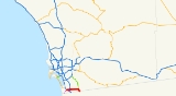
State Route 905 is a state highway
in San Diego, California
that connects Interstate 5 and Interstate 805 in San Ysidro to the United States – Mexico border at Otay Mesa. The portions of the route from I-5 to I-805 and from Britannia Boulevard to the International border are freeway. The remainder of the route is an expressway
known as Otay Mesa Road.
The entire route is currently being upgraded to Interstate standards. Once completed, it will become Interstate 905. This route is part of the California Freeway and Expressway System
.
. SR 905 becomes Otay Mesa Road and heads east as a highway past Brown Field
. The route temporarily turns south on Britannia Boulevard for a short distance to connect to a new freeway segment (via a partially completed interchange) parallel to Otay Mesa Road. At this point, SR 905 turns east onto the new freeway segment, with a interchange at La Media Road. The route turns southeast to its final interchange at Siempre Viva Road. Following this, SR 905 ends at the Mexican border.
Previously, SR 905 had a direct connection with SR 125
via two at-grade intersections on Otay Mesa Road. With the completion of the newest freeway segment of SR 905 and the freeway-to-freeway connection to SR 125 unconstructed, eastbound traffic on SR 905 can continue on Otay Mesa Road past Britannia Boulevard to make the connection, while westbound traffic must exit at La Media Road (exit 7), head north on La Media and head east on Otay Mesa Road to make the connection. A freeway-to-freeway interchange is planned for the connection between SR 125 and SR 905; this interchange will be built when the new SR 11 freeway is constructed. SR 11 will be a toll facility that will serve a new border crossing east of Otay Mesa.
The final freeway segment of SR 905 between I-805 and Britannia Boulevard is scheduled for completion in 2012.
in 1959 as Legislative Route 281, and became part of State Route 75 in the 1964 renumbering. In 1972, the legislature added a new State Route 117, which extended this part of SR 75 southwest to the Mexican border near Border Field State Park
, to the state highway system, and a southerly extension of SR 125 to the border at Otay Mesa to the state highway and Freeway and Expressway systems. SR 117 was extended east to SR 125, replacing this southerly segment of SR 75, in 1976. The Federal Highway Administration
approved the continuous roadway via SR 117 and SR 125 from I-5 to the border at Otay Mesa as a non-chargeable (not eligible for federal interstate construction dollars) part of the Interstate Highway System
in October 1984, and the number was legislatively changed to 905 in 1986. The original piece of SR 117 (west of I-5), which is not part of the Interstate Highway or California Freeway and Expressway Systems, also became SR 905, but Caltrans has no plans to construct it.
announced they had been awarded a contract by Caltrans to construct a freeway along Route 905 between I-805 and State Route 125:
Once the highway has been fully upgraded to Interstate standards, it will become Interstate 905 and it will connect to State Route 125. Once designated, it will become only the third auxiliary three-digit Interstate to meet an international border (the other two being Interstate 190
in New York
and Interstate 110
in Texas
) and the second to touch the United States-Mexico border. It will also be only the second purely east-west Interstate to connect with a foreign country, after Interstate 94
, which connects with Canada.
|colspan=4 align=center|East end of freeway
|-
|colspan=4 align=center|West end of freeway
State highway
State highway, state road or state route can refer to one of three related concepts, two of them related to a state or provincial government in a country that is divided into states or provinces :#A...
in San Diego, California
San Diego, California
San Diego is the eighth-largest city in the United States and second-largest city in California. The city is located on the coast of the Pacific Ocean in Southern California, immediately adjacent to the Mexican border. The birthplace of California, San Diego is known for its mild year-round...
that connects Interstate 5 and Interstate 805 in San Ysidro to the United States – Mexico border at Otay Mesa. The portions of the route from I-5 to I-805 and from Britannia Boulevard to the International border are freeway. The remainder of the route is an expressway
Limited-access road
A limited-access road known by various terms worldwide, including limited-access highway, dual-carriageway and expressway, is a highway or arterial road for high-speed traffic which has many or most characteristics of a controlled-access highway , including limited or no access to adjacent...
known as Otay Mesa Road.
The entire route is currently being upgraded to Interstate standards. Once completed, it will become Interstate 905. This route is part of the California Freeway and Expressway System
California Freeway and Expressway System
The California Freeway and Expressway System is a system of existing or planned freeways and expressways in the U.S. state of California. It is defined by the Streets and Highways Code.-List of roads in the system:*State Route 1 *State Route 2...
.
Route description
SR 905 begins at the intersection of Tocayo Avenue and Oro Vista Road in San Ysidro. It begins as a freeway, intersecting with I-5 and then I-805 after a few exits. Following this, SR 905 intersects Otay Mesa Road at an at-grade intersectionAt-grade intersection
An at-grade intersection is a junction at which two or more transport axes cross at the same level .-Traffic management:With areas of high or fast traffic, an at-grade intersection normally requires a traffic control device such as a stop sign, traffic light or railway signal to manage conflicting...
. SR 905 becomes Otay Mesa Road and heads east as a highway past Brown Field
Brown Field
Brown Field Municipal Airport is located in the Otay Mesa neighborhood of San Diego, California, southeast of Downtown San Diego and named in honor of Commander Melville S. Brown, USN, who was killed in an airplane crash in 1936. Its primary runway is long....
. The route temporarily turns south on Britannia Boulevard for a short distance to connect to a new freeway segment (via a partially completed interchange) parallel to Otay Mesa Road. At this point, SR 905 turns east onto the new freeway segment, with a interchange at La Media Road. The route turns southeast to its final interchange at Siempre Viva Road. Following this, SR 905 ends at the Mexican border.
Previously, SR 905 had a direct connection with SR 125
California State Route 125
State Route 125 is a state highway in the U.S. state of California that currently runs from State Route 905 in Otay Mesa near the U.S.–Mexico border to State Route 52 in Santee....
via two at-grade intersections on Otay Mesa Road. With the completion of the newest freeway segment of SR 905 and the freeway-to-freeway connection to SR 125 unconstructed, eastbound traffic on SR 905 can continue on Otay Mesa Road past Britannia Boulevard to make the connection, while westbound traffic must exit at La Media Road (exit 7), head north on La Media and head east on Otay Mesa Road to make the connection. A freeway-to-freeway interchange is planned for the connection between SR 125 and SR 905; this interchange will be built when the new SR 11 freeway is constructed. SR 11 will be a toll facility that will serve a new border crossing east of Otay Mesa.
The final freeway segment of SR 905 between I-805 and Britannia Boulevard is scheduled for completion in 2012.
History
The majority of SR 905, paralleling Otay Mesa Road from I-5 to SR 125, was added to the state highway system and California Freeway and Expressway SystemCalifornia Freeway and Expressway System
The California Freeway and Expressway System is a system of existing or planned freeways and expressways in the U.S. state of California. It is defined by the Streets and Highways Code.-List of roads in the system:*State Route 1 *State Route 2...
in 1959 as Legislative Route 281, and became part of State Route 75 in the 1964 renumbering. In 1972, the legislature added a new State Route 117, which extended this part of SR 75 southwest to the Mexican border near Border Field State Park
Border Field State Park
Border Field State Park is a state park of California, USA, containing beach and coastal habitat on the Mexico – United States border. The park is located within the city limits of Imperial Beach in San Diego County, adjacent to the suburb of Playas de Tijuana in Mexico...
, to the state highway system, and a southerly extension of SR 125 to the border at Otay Mesa to the state highway and Freeway and Expressway systems. SR 117 was extended east to SR 125, replacing this southerly segment of SR 75, in 1976. The Federal Highway Administration
Federal Highway Administration
The Federal Highway Administration is a division of the United States Department of Transportation that specializes in highway transportation. The agency's major activities are grouped into two "programs," the Federal-aid Highway Program and the Federal Lands Highway Program...
approved the continuous roadway via SR 117 and SR 125 from I-5 to the border at Otay Mesa as a non-chargeable (not eligible for federal interstate construction dollars) part of the Interstate Highway System
Interstate Highway System
The Dwight D. Eisenhower National System of Interstate and Defense Highways, , is a network of limited-access roads including freeways, highways, and expressways forming part of the National Highway System of the United States of America...
in October 1984, and the number was legislatively changed to 905 in 1986. The original piece of SR 117 (west of I-5), which is not part of the Interstate Highway or California Freeway and Expressway Systems, also became SR 905, but Caltrans has no plans to construct it.
Future
In February 2008, multinational construction group SkanskaSkanska
Skanska AB, is a multinational construction and development company based in Sweden, where it also is the largest construction company. The company's head office is in Solna, north of Stockholm.-History:...
announced they had been awarded a contract by Caltrans to construct a freeway along Route 905 between I-805 and State Route 125:
The project comprises new construction of about four kilometers (2.5 mi) of six-lane freeway. Construction will require major grading operations for the base and 103,000 tons of asphalt. The contract also covers five bridges, landscaping, storm drains and irrigation system as well as all installations of signal and safety systems.
Once the highway has been fully upgraded to Interstate standards, it will become Interstate 905 and it will connect to State Route 125. Once designated, it will become only the third auxiliary three-digit Interstate to meet an international border (the other two being Interstate 190
Interstate 190 (New York)
Interstate 190 runs 28.34 miles from Interstate 90 near Buffalo, New York to Lewiston, New York via Niagara Falls. Parts of this highway were built on the former rights-of-way of the Lehigh Valley Railroad and the Erie Canal. It is referred to by locals as The One-Ninety...
in New York
New York
New York is a state in the Northeastern region of the United States. It is the nation's third most populous state. New York is bordered by New Jersey and Pennsylvania to the south, and by Connecticut, Massachusetts and Vermont to the east...
and Interstate 110
Interstate 110 (Texas)
Interstate 110 is a spur route in El Paso extending from Interstate 10, south along U.S. Highway 54, turns west then turns south into Mexico. Interstate 110 provides access from Interstate 10 to the Bridge of the Americas , which spans the Rio Grande to connect with Avenida Abraham Lincoln in...
in Texas
Texas
Texas is the second largest U.S. state by both area and population, and the largest state by area in the contiguous United States.The name, based on the Caddo word "Tejas" meaning "friends" or "allies", was applied by the Spanish to the Caddo themselves and to the region of their settlement in...
) and the second to touch the United States-Mexico border. It will also be only the second purely east-west Interstate to connect with a foreign country, after Interstate 94
Interstate 94
Interstate 94 is the northernmost east–west Interstate Highway, connecting the Great Lakes and Intermountain regions of the United States. I-94's western terminus is in Billings, Montana at a junction with Interstate 90; its eastern terminus is the U.S...
, which connects with Canada.
Exit list
|-|colspan=4 align=center|East end of freeway
|-
|colspan=4 align=center|West end of freeway