
Lower Ninth Ward
Encyclopedia
Lower Ninth Ward is a neighborhood
of the city of New Orleans. As the name implies, it is part of the Ninth Ward of New Orleans
. The Lower Ninth Ward is often thought of as the entire area within New Orleans downriver of the Industrial Canal
; however, the City Planning Commission divides this area into the Lower Ninth Ward (2) and Holy Cross
(3) neighborhoods.
The term "Lower" refers to its location farther towards the mouth of the Mississippi River
, "down" or "below" the rest of the city in local geographic terminology. But the 9th Ward, like all Wards in New Orleans, is a voting district. The 9th Ward was added as a voting district in 1852. The "lower" 9th Ward is composed of Ward 9 Districts 1, 2, 4, and 7 which make up the Holy Cross Area and Ward 9 Districts 3, 5, 6, and 8. Higher voting district numbers in the 9th Ward (8-27) are on the upriver side of the Industrial Canal. The area came to national attention for its devastation in the aftermath of Hurricane Katrina
in 2005.
, the neighborhood of the Lower 9th Ward is about 1.25 mi (2 km) from east to west and 2 mi (3.2 km) from north to south. Three major avenues cross the developed portion of the neighborhood, each with bridges over the Industrial Canal
. Closest to the River is St. Claude Avenue; about midway through the neighborhood is Claiborne Avenue
; Florida Avenue crosses at the northern edge of the historically populated portion of the Lower 9th. Most major businesses serving the neighborhood are located on St. Claude or Claiborne, although a smattering of additional neighborhood business is located throughout the area. While the first two of these three avenues continue into St. Bernard Parish
; a continuation of Florida Avenue through and beyond the parish line has been repeatedly proposed but at present does not exist.
The Lower Ninth Ward is also commonly used to describe a slightly larger area. This area borders the Mississippi River to the South and St. Bernard Parish
to the east. To the west is the Industrial Canal
, across which is the Bywater
section of New Orleans. The northern or inland boundary is often given as the Florida Canal
with Florida Avenue, a levee, and railroad tracks running beside it. Alternatively, the industrial area north of Florida Avenue is sometimes included as being part of the Lower 9th Ward, extending the boundary to the southern edge of the Gulf Intracoastal Waterway
.
's colonial era this was plantation
land. The portion closer to the river was developed for residential use at the start of the 19th century at the same time as the Bywater area. In 1834 the United States Army
established the Jackson Barracks
here. As late as the 1870s the area behind St. Claude was still mostly small farms with scattered residences, and the area on the "woods" (away from the river) side of Claiborne
mostly undeveloped cypress
swamp
.
What became the Lower 9th Ward did not become distinct from the parts of the 9th Ward just upriver until the Industrial Canal
was dredged at the start of the 1920s, bisecting the 9th Ward. At this time, people started referring to the area "above" (up river) from the Canal as the "Upper" 9th Ward, and this area as the "Lower".
The Industrial Canal prompted development of the land farther back along the Canal, and provided steady work for labor in the area. As shipping became containerized
in the later 20th century, demand for labor declined with negative economic consequences on the neighborhood.
hit New Orleans. A levee
on the Industrial Canal collapsed, flooding much of the Lower 9th Ward.
President Lyndon B. Johnson
visited the devastated flooded area shortly after the storm, and ordered aid for the storm victims.
hit New Orleans. Multiple breaches in the levees of at least four canals resulted in catastrophic flooding of the majority of the city; see Effect of Hurricane Katrina on New Orleans
.
 Nowhere in the city was the devastation greater than in the Lower 9th Ward, especially the portion from Claiborne Avenue back. This was largely due to the storm surge generated in the Mississippi River Gulf Outlet, a deep-draft shipping channel built by the Army Corps of Engineers in the late 1950s, which destroyed tens of thousands of acres of protective coastal wetlands that once acted as a storm surge buffer for the community. Storm surge
flood waters appear to have poured into the neighborhood from at least three sources. To the east, water flowed in from Saint Bernard Parish, while to the west the Industrial Canal suffered two distinct major breaches: one a block in from Florida Avenue, the second back from Claiborne Avenue. The force of the water did not merely flood homes, but smashed or knocked many off their foundations. A large barge, the ING 4727
(owned by the Ingram Barge Company
) came into the neighborhood through the breach near Claiborne Avenue, leveling homes beneath it as it floated in the flood waters. Storm surge was so great that even the highest portions of the Lower 9th were flooded; Holy Cross School, which had served as a dry refuge after Hurricane Betsy
, was inundated, and even the foot of the Mississippi River levee, the area's highest point, took on some 2 to 3 foot (0.9144 m) of water.
In December 2005 Common Ground Collective
volunteers gutted the first house in the area. From there volunteers and residents began gutting other houses in the community. Soon after Common Ground Collective opened the first distribution center in the area to provide returning residents with water, food and other necessities while there were no stores open in the area.
In January 2006, the great devastation and difficulties in restoring basic utilities and city services made the Lower 9th Ward the last portion of the city of New Orleans not officially reopened to residents who wished to return to live. It was the last area of the city still under a curfew
half a year after the disaster. Officially residents were allowed in during daylight hours to look, salvage possessions, and leave, although some few had already done extensive work gutting and repairing their damaged homes in preparation to move back.
The most severely damaged section of the Ward is the lower elevation section, north of Claiborne Avenue. A Bring Back New Orleans Commission preliminary report suggested making this area in whole or part into park space. The suggestion is vehemently objected to by most Lower 9th Ward residents.
In March 2006 a group of residents and Common Ground Collective volunteers broke into Martin Luther King Elementary School to begin cleanup efforts. Not long after, the state school officials agreed to repair the school. The school has subsequently become a Recovery School District
charter school
and is running at full capacity. It is a rarity in that it has no management company. The school is operated by the faculty and administration. When asked about it Dr. Hicks, the school's long-time principal said "We didn't have a management company before and we don't need one now."
As of late 2006, a small number of local businesses in the area reopened and residents returned (many living in FEMA trailer
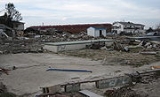
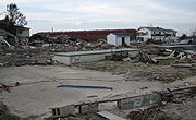
s). However, much of the area is still little-populated and in ruined condition. Work crews continue to remove debris and demolish unrepairable houses daily, but hundreds if not thousands are vacant and gutted. Many more buildings are still little touched since the waters were drained, with ruined possessions still inside severely damaged buildings.
 In 2006, Mayor Ray Nagin
threatened to use his powers of eminent domain
to seize vacant severely damaged property in all of New Orleans that had not been gutted or scheduled to be gutted before early 2007. Such blighted property has been creating serious problems for returned New Orleanians, including infestations of rats and other vermin. Similar movements to seize abandoned blighted property are in effect in other parishes as well as Mississippi counties affected by the storm. However, as hundreds of thousands of locals are still waiting for promised insurance or Road Home
money, many of the poor lack resources. The neighborhood has few stores and only a handful of schools reopened.
On December 3, 2007, Make It Right, founded by actor Brad Pitt
, committed to rebuild 150 houses in the Lower Ninth Ward. The houses are sustainable
, energy-efficient and safe. Make It Right homes were designed by award-winning architects from New Orleans and around the world, including Frank Gehry, Shigeru Ban, Hitoshi Abe and Thom Mayne.
In the spring of 2008, Build Now
, a local, non-profit homebuilder, began playing an active part in bringing New Orleans families back home. Build Now is a licensed and insured residential contractor that constructs site-built, stilt house
s on hurricane-damaged lots. The homes reflect the style and quality of traditional New Orleans architecture. Build Now is in the process of bringing more than a dozen New Orleans families back home; 9 houses are currently under construction in the Upper and Lower Ninth Ward areas, Lakeview and Gentilly. The organization has moved 3 New Orleans families back home.
As of March 2009, hundreds of houses have been rebuilt and dozens of new homes have been constructed. While there is a long way to go residents are returning home. Volunteers continue to come to the area en masse working for dozens of organizations including Common Ground Relief, formerly Common Ground Collective, and lowernine.org
, a grassroots
organization that coordinates volunteers' and residents' efforts in rebuilding homes in the Lower Ninth Ward. As of February 2010, lowernine.org enabled 29 families to move back home to the Lower Ninth Ward.
Today residents and volunteers are striving to make the Lower Ninth Ward a sustainable community
. They are working to restore the local wetland
s. It is widely believed that were it not for extensive canal dredging for the purposes of commercial ventures, and the subsequent wetlands subsidence that the Lower Ninth Ward would not have suffered extensive flooding during Katrina.
 The Lower Ninth Ward is also home to the Jackson Barracks
. The barracks now serve as headquarters for the Louisiana National Guard
, and had an extensive military museum in the old powder magazine and in a new annex, with a large collection of military items from every American war. The 2000 NRA
Shooting Sports Camp and Coaches School was held at Jackson Barracks from June 28 – July 2, 2000.
The Doullut steamboat houses sit on either side of Egania Street in the Lower Ninth Ward at numbers 400 and 503. The first house, closer to the river, was built in 1905 by Captain Milton P. Doullut as his home. The second was built in 1913 for his son Paul. In 1977 both houses were designated historic landmarks. The houses have two notable design influences, the first being the steamboats of the period, the second being the Japanese exhibit at the 1904 World's Fair in St. Louis (Louisiana Purchase Exposition
). Notably, Milton P. Doullut's wife was also a captain and is believed to be the first woman to have held a Mississippi riverboat pilot's license.
Major sections of the Mississippi River embankment along the Lower Ninth Ward and inside the Jackson Barracks were used for filming the 1994 film adaptation
of Anne Rice's Interview with the Vampire
, starring Brad Pitt and Tom Cruise.
Notable Lower 9th Ward residents include musician singer songwriter Fats Domino
, NFL star Marshall Faulk
, poet and author Kalamu ya Salaam
, and rapper Magic
.
The section on the River side of Saint Claude Avenue which developed as an urban area first is sometimes called the "Holy Cross Neighborhood" for Holy Cross High School, the large Catholic school
there, which long drew students not only from the Lower 9th but from throughout the city.
New Orleans neighborhoods
In 1980 the New Orleans City Planning Commission divided the city into 13 planning districts and 72 distinct neighborhoods.While most of these assigned boundaries match with traditional local designations, some others differ from common traditional use...
of the city of New Orleans. As the name implies, it is part of the Ninth Ward of New Orleans
Ninth Ward of New Orleans
The Ninth Ward or 9th Ward is a distinctive region of New Orleans, Louisiana that is located in the easternmost downriver portion of the city. It is geographically the largest of the 17 Wards of New Orleans....
. The Lower Ninth Ward is often thought of as the entire area within New Orleans downriver of the Industrial Canal
Industrial Canal
The Industrial Canal is a 5.5 mile waterway in New Orleans, Louisiana, United States. The waterway's proper name, as used by the U.S. Army Corps of Engineers and on NOAA nautical charts, is Inner Harbor Navigation Canal...
; however, the City Planning Commission divides this area into the Lower Ninth Ward (2) and Holy Cross
Holy Cross, New Orleans
Holy Cross is a neighborhood of the city of New Orleans. A subdistrict of the Lower Ninth Ward District Area, its boundaries as defined by the City Planning Commission are: St. Claude Avenue to the north, St. Bernard Parish to the east, the Mississippi River to the south and the Industrial Canal...
(3) neighborhoods.
The term "Lower" refers to its location farther towards the mouth of the Mississippi River
Mississippi River
The Mississippi River is the largest river system in North America. Flowing entirely in the United States, this river rises in western Minnesota and meanders slowly southwards for to the Mississippi River Delta at the Gulf of Mexico. With its many tributaries, the Mississippi's watershed drains...
, "down" or "below" the rest of the city in local geographic terminology. But the 9th Ward, like all Wards in New Orleans, is a voting district. The 9th Ward was added as a voting district in 1852. The "lower" 9th Ward is composed of Ward 9 Districts 1, 2, 4, and 7 which make up the Holy Cross Area and Ward 9 Districts 3, 5, 6, and 8. Higher voting district numbers in the 9th Ward (8-27) are on the upriver side of the Industrial Canal. The area came to national attention for its devastation in the aftermath of Hurricane Katrina
Hurricane Katrina
Hurricane Katrina of the 2005 Atlantic hurricane season was a powerful Atlantic hurricane. It is the costliest natural disaster, as well as one of the five deadliest hurricanes, in the history of the United States. Among recorded Atlantic hurricanes, it was the sixth strongest overall...
in 2005.
Geography
Excluding the industrial and swamp areas north of the Florida CanalFlorida Canal
The Florida Canal or 40 Arpent Canal is a canal in the New Orleans metropolitan area and land down river.The canal was built in the 18th century colonial era of Louisiana, stretching from what is now the Faubourg Marigny neighborhood of New Orleans, roughly paralleling the Mississippi River on the...
, the neighborhood of the Lower 9th Ward is about 1.25 mi (2 km) from east to west and 2 mi (3.2 km) from north to south. Three major avenues cross the developed portion of the neighborhood, each with bridges over the Industrial Canal
Industrial Canal
The Industrial Canal is a 5.5 mile waterway in New Orleans, Louisiana, United States. The waterway's proper name, as used by the U.S. Army Corps of Engineers and on NOAA nautical charts, is Inner Harbor Navigation Canal...
. Closest to the River is St. Claude Avenue; about midway through the neighborhood is Claiborne Avenue
Claiborne Avenue
Claiborne Avenue is a major thoroughfare in New Orleans, Louisiana. It runs the length of the city, about , beginning at the Jefferson Parish line and ending at the St. Bernard Parish line; the street continues in each of these locations under different names. It is called South Claiborne Avenue...
; Florida Avenue crosses at the northern edge of the historically populated portion of the Lower 9th. Most major businesses serving the neighborhood are located on St. Claude or Claiborne, although a smattering of additional neighborhood business is located throughout the area. While the first two of these three avenues continue into St. Bernard Parish
St. Bernard Parish, Louisiana
St. Bernard Parish is a parish located southeast of New Orleans in the U.S. state of Louisiana. The parish seat is Chalmette, the largest city in the parish. As of 2000, its population was 67,229. It has been ranked the fastest-growing county in the United States from 2007 to 2008 by the U.S....
; a continuation of Florida Avenue through and beyond the parish line has been repeatedly proposed but at present does not exist.
Adjacent Neighborhoods
- Viavant/Venetian IslesVenetian Isles, New OrleansVenetian Isles is a neighborhood of New Orleans, Louisiana. It is located on the western shore of the Chef Menteur Pass on the northern side of U.S. Highway 90....
(north) - St. Bernard ParishSt. Bernard Parish, LouisianaSt. Bernard Parish is a parish located southeast of New Orleans in the U.S. state of Louisiana. The parish seat is Chalmette, the largest city in the parish. As of 2000, its population was 67,229. It has been ranked the fastest-growing county in the United States from 2007 to 2008 by the U.S....
(east) - Holy CrossHoly Cross, New OrleansHoly Cross is a neighborhood of the city of New Orleans. A subdistrict of the Lower Ninth Ward District Area, its boundaries as defined by the City Planning Commission are: St. Claude Avenue to the north, St. Bernard Parish to the east, the Mississippi River to the south and the Industrial Canal...
(south) - BywaterBywater, New OrleansBywater is a neighborhood of the city of New Orleans. A subdistrict of the Bywater District Area, its boundaries as defined by the City Planning Commission are: Florida Avenue to the north, the Industrial Canal to the east, the Mississippi River to the south and Franklin Avenue Street to the west...
(west)
Boundaries
The City Planning Commission defines the boundaries of Lower Ninth Ward as these streets: Florida Avenue, St. Bernard Parish, St. Claude Avenue and the Industrial Canal.The Lower Ninth Ward is also commonly used to describe a slightly larger area. This area borders the Mississippi River to the South and St. Bernard Parish
St. Bernard Parish, Louisiana
St. Bernard Parish is a parish located southeast of New Orleans in the U.S. state of Louisiana. The parish seat is Chalmette, the largest city in the parish. As of 2000, its population was 67,229. It has been ranked the fastest-growing county in the United States from 2007 to 2008 by the U.S....
to the east. To the west is the Industrial Canal
Industrial Canal
The Industrial Canal is a 5.5 mile waterway in New Orleans, Louisiana, United States. The waterway's proper name, as used by the U.S. Army Corps of Engineers and on NOAA nautical charts, is Inner Harbor Navigation Canal...
, across which is the Bywater
Bywater, New Orleans
Bywater is a neighborhood of the city of New Orleans. A subdistrict of the Bywater District Area, its boundaries as defined by the City Planning Commission are: Florida Avenue to the north, the Industrial Canal to the east, the Mississippi River to the south and Franklin Avenue Street to the west...
section of New Orleans. The northern or inland boundary is often given as the Florida Canal
Florida Canal
The Florida Canal or 40 Arpent Canal is a canal in the New Orleans metropolitan area and land down river.The canal was built in the 18th century colonial era of Louisiana, stretching from what is now the Faubourg Marigny neighborhood of New Orleans, roughly paralleling the Mississippi River on the...
with Florida Avenue, a levee, and railroad tracks running beside it. Alternatively, the industrial area north of Florida Avenue is sometimes included as being part of the Lower 9th Ward, extending the boundary to the southern edge of the Gulf Intracoastal Waterway
Gulf Intracoastal Waterway
The Gulf Intracoastal Waterway is the portion of the Intracoastal Waterway located along the Gulf Coast of the United States. It is a navigable inland waterway running approximately 1700 kilometers from Carrabelle, Florida, to Brownsville, Texas.The waterway provides a channel with a controlling...
.
History
In LouisianaLouisiana
Louisiana is a state located in the southern region of the United States of America. Its capital is Baton Rouge and largest city is New Orleans. Louisiana is the only state in the U.S. with political subdivisions termed parishes, which are local governments equivalent to counties...
's colonial era this was plantation
Plantation
A plantation is a long artificially established forest, farm or estate, where crops are grown for sale, often in distant markets rather than for local on-site consumption...
land. The portion closer to the river was developed for residential use at the start of the 19th century at the same time as the Bywater area. In 1834 the United States Army
United States Army
The United States Army is the main branch of the United States Armed Forces responsible for land-based military operations. It is the largest and oldest established branch of the U.S. military, and is one of seven U.S. uniformed services...
established the Jackson Barracks
Jackson Barracks
Jackson Barracks is a military base in New Orleans, Louisiana. The base was established in 1834 and known as New Orleans Barracks prior to 7 July 1866 when it was renamed in honor of Andrew Jackson who first advocated a US military base here....
here. As late as the 1870s the area behind St. Claude was still mostly small farms with scattered residences, and the area on the "woods" (away from the river) side of Claiborne
Claiborne Avenue
Claiborne Avenue is a major thoroughfare in New Orleans, Louisiana. It runs the length of the city, about , beginning at the Jefferson Parish line and ending at the St. Bernard Parish line; the street continues in each of these locations under different names. It is called South Claiborne Avenue...
mostly undeveloped cypress
Taxodium
Taxodium is a genus of one to three species of extremely flood-tolerant conifers in the cypress family, Cupressaceae...
swamp
Swamp
A swamp is a wetland with some flooding of large areas of land by shallow bodies of water. A swamp generally has a large number of hammocks, or dry-land protrusions, covered by aquatic vegetation, or vegetation that tolerates periodical inundation. The two main types of swamp are "true" or swamp...
.
What became the Lower 9th Ward did not become distinct from the parts of the 9th Ward just upriver until the Industrial Canal
Industrial Canal
The Industrial Canal is a 5.5 mile waterway in New Orleans, Louisiana, United States. The waterway's proper name, as used by the U.S. Army Corps of Engineers and on NOAA nautical charts, is Inner Harbor Navigation Canal...
was dredged at the start of the 1920s, bisecting the 9th Ward. At this time, people started referring to the area "above" (up river) from the Canal as the "Upper" 9th Ward, and this area as the "Lower".
The Industrial Canal prompted development of the land farther back along the Canal, and provided steady work for labor in the area. As shipping became containerized
Containerization
Containerization is a system of freight transport based on a range of steel intermodal containers...
in the later 20th century, demand for labor declined with negative economic consequences on the neighborhood.
Betsy
In 1965, Hurricane BetsyHurricane Betsy
Hurricane Betsy was a Category 4 hurricane of the 1965 Atlantic hurricane season which caused enormous damage in the Bahamas, Florida, and Louisiana. Betsy made its most intense landfall near the mouth of the Mississippi River, causing significant flooding of the waters of Lake Pontchartrain into...
hit New Orleans. A levee
Levee
A levee, levée, dike , embankment, floodbank or stopbank is an elongated naturally occurring ridge or artificially constructed fill or wall, which regulates water levels...
on the Industrial Canal collapsed, flooding much of the Lower 9th Ward.
President Lyndon B. Johnson
Lyndon B. Johnson
Lyndon Baines Johnson , often referred to as LBJ, was the 36th President of the United States after his service as the 37th Vice President of the United States...
visited the devastated flooded area shortly after the storm, and ordered aid for the storm victims.
Katrina
In 2005, Hurricane KatrinaHurricane Katrina
Hurricane Katrina of the 2005 Atlantic hurricane season was a powerful Atlantic hurricane. It is the costliest natural disaster, as well as one of the five deadliest hurricanes, in the history of the United States. Among recorded Atlantic hurricanes, it was the sixth strongest overall...
hit New Orleans. Multiple breaches in the levees of at least four canals resulted in catastrophic flooding of the majority of the city; see Effect of Hurricane Katrina on New Orleans
Effect of Hurricane Katrina on New Orleans
The effects of Hurricane Katrina in New Orleans have been long-lasting. As the center of Katrina passed South-east of New Orleans on August 29, 2005, winds downtown were in the Category 3 range with frequent intense gusts and tidal surge. Hurricane force winds were experienced throughout the...
.
Storm surge
A storm surge is an offshore rise of water associated with a low pressure weather system, typically tropical cyclones and strong extratropical cyclones. Storm surges are caused primarily by high winds pushing on the ocean's surface. The wind causes the water to pile up higher than the ordinary sea...
flood waters appear to have poured into the neighborhood from at least three sources. To the east, water flowed in from Saint Bernard Parish, while to the west the Industrial Canal suffered two distinct major breaches: one a block in from Florida Avenue, the second back from Claiborne Avenue. The force of the water did not merely flood homes, but smashed or knocked many off their foundations. A large barge, the ING 4727
ING 4727
ING 4727 was a barge belonging to Ingram Barge Company that became infamous when it went over or through a levee and landed in a residential neighborhood of New Orleans, Louisiana during Hurricane Katrina.-Background and specifications:...
(owned by the Ingram Barge Company
Ingram Barge Company
The Ingram Barge Company is a barge company based in Nashville, Tennessee, United States.According to the company website, Ingram operates nearly 4,000 barges with a fleet of over 80 linehaul vessels and over 30 tug boats...
) came into the neighborhood through the breach near Claiborne Avenue, leveling homes beneath it as it floated in the flood waters. Storm surge was so great that even the highest portions of the Lower 9th were flooded; Holy Cross School, which had served as a dry refuge after Hurricane Betsy
Hurricane Betsy
Hurricane Betsy was a Category 4 hurricane of the 1965 Atlantic hurricane season which caused enormous damage in the Bahamas, Florida, and Louisiana. Betsy made its most intense landfall near the mouth of the Mississippi River, causing significant flooding of the waters of Lake Pontchartrain into...
, was inundated, and even the foot of the Mississippi River levee, the area's highest point, took on some 2 to 3 foot (0.9144 m) of water.
In December 2005 Common Ground Collective
Common Ground Collective
The Common Ground Collective is a decentralized network of non-profit organizations offering support to the residents of New Orleans. It was formed in the Algiers neighborhood of the city in the days after Hurricane Katrina in 2005.-History:...
volunteers gutted the first house in the area. From there volunteers and residents began gutting other houses in the community. Soon after Common Ground Collective opened the first distribution center in the area to provide returning residents with water, food and other necessities while there were no stores open in the area.
In January 2006, the great devastation and difficulties in restoring basic utilities and city services made the Lower 9th Ward the last portion of the city of New Orleans not officially reopened to residents who wished to return to live. It was the last area of the city still under a curfew
Curfew
A curfew is an order specifying a time after which certain regulations apply. Examples:# An order by a government for certain persons to return home daily before a certain time...
half a year after the disaster. Officially residents were allowed in during daylight hours to look, salvage possessions, and leave, although some few had already done extensive work gutting and repairing their damaged homes in preparation to move back.
The most severely damaged section of the Ward is the lower elevation section, north of Claiborne Avenue. A Bring Back New Orleans Commission preliminary report suggested making this area in whole or part into park space. The suggestion is vehemently objected to by most Lower 9th Ward residents.
In March 2006 a group of residents and Common Ground Collective volunteers broke into Martin Luther King Elementary School to begin cleanup efforts. Not long after, the state school officials agreed to repair the school. The school has subsequently become a Recovery School District
Recovery School District
The is a special statewide school district administered by the Louisiana Department of Education. Created by legislation passed in 2003, the RSD is designed to take underperforming schools and transform them into successful places for children to learn...
charter school
Charter school
Charter schools are primary or secondary schools that receive public money but are not subject to some of the rules, regulations, and statutes that apply to other public schools in exchange for some type of accountability for producing certain results, which are set forth in each school's charter...
and is running at full capacity. It is a rarity in that it has no management company. The school is operated by the faculty and administration. When asked about it Dr. Hicks, the school's long-time principal said "We didn't have a management company before and we don't need one now."
As of late 2006, a small number of local businesses in the area reopened and residents returned (many living in FEMA trailer
FEMA trailer
The term FEMA trailer,or FEMA travel trailer, is the name commonly given by the United States Government to many forms of temporary manufactured housing assigned to the victims of Hurricane Katrina, Hurricane Rita or other events, by the Federal Emergency Management Agency...
s). However, much of the area is still little-populated and in ruined condition. Work crews continue to remove debris and demolish unrepairable houses daily, but hundreds if not thousands are vacant and gutted. Many more buildings are still little touched since the waters were drained, with ruined possessions still inside severely damaged buildings.
Ray Nagin
Clarence Ray Nagin, Jr. is a former mayor of New Orleans, Louisiana, United States. Nagin gained international note in 2005 in the aftermath of Hurricane Katrina, which devastated the New Orleans area....
threatened to use his powers of eminent domain
Eminent domain
Eminent domain , compulsory purchase , resumption/compulsory acquisition , or expropriation is an action of the state to seize a citizen's private property, expropriate property, or seize a citizen's rights in property with due monetary compensation, but without the owner's consent...
to seize vacant severely damaged property in all of New Orleans that had not been gutted or scheduled to be gutted before early 2007. Such blighted property has been creating serious problems for returned New Orleanians, including infestations of rats and other vermin. Similar movements to seize abandoned blighted property are in effect in other parishes as well as Mississippi counties affected by the storm. However, as hundreds of thousands of locals are still waiting for promised insurance or Road Home
Road Home
Road Home is a program funded by the U.S. government which has provided historical federal monies for helping Louisiana residents rebuild or sell houses severely damaged by Hurricanes Katrina and Rita. The Road Home is a federally funded grant program adminsitered by the State of Louisiana...
money, many of the poor lack resources. The neighborhood has few stores and only a handful of schools reopened.
On December 3, 2007, Make It Right, founded by actor Brad Pitt
Brad Pitt
William Bradley "Brad" Pitt is an American actor and film producer. Pitt has received two Academy Award nominations and four Golden Globe Award nominations, winning one...
, committed to rebuild 150 houses in the Lower Ninth Ward. The houses are sustainable
Green building
Green building refers to a structure and using process that is environmentally responsible and resource-efficient throughout a building's life-cycle: from siting to design, construction, operation, maintenance, renovation, and demolition...
, energy-efficient and safe. Make It Right homes were designed by award-winning architects from New Orleans and around the world, including Frank Gehry, Shigeru Ban, Hitoshi Abe and Thom Mayne.
In the spring of 2008, Build Now
Build Now
Build Now is a non-profit organization located in New Orleans, Louisiana, that works with clients whose homes were destroyed as a result of Hurricane Katrina to build new homes on their property. Build Now was founded by New Orleans native, William Monaghan and is now directed by his daughter Tess...
, a local, non-profit homebuilder, began playing an active part in bringing New Orleans families back home. Build Now is a licensed and insured residential contractor that constructs site-built, stilt house
Stilt house
Stilt houses or pile dwellings or palafitte are houses raised on piles over the surface of the soil or a body of water. Stilt houses are built primarily as a protection against flooding, but also serve to keep out vermin...
s on hurricane-damaged lots. The homes reflect the style and quality of traditional New Orleans architecture. Build Now is in the process of bringing more than a dozen New Orleans families back home; 9 houses are currently under construction in the Upper and Lower Ninth Ward areas, Lakeview and Gentilly. The organization has moved 3 New Orleans families back home.
As of March 2009, hundreds of houses have been rebuilt and dozens of new homes have been constructed. While there is a long way to go residents are returning home. Volunteers continue to come to the area en masse working for dozens of organizations including Common Ground Relief, formerly Common Ground Collective, and lowernine.org
Lowernine.org
lowernine.org is a volunteer organization established in 2007, after the end of Emergency Communities, one of the first nonprofit organizations formed as of the result of Hurricane Katrina in 2005...
, a grassroots
Grassroots
A grassroots movement is one driven by the politics of a community. The term implies that the creation of the movement and the group supporting it are natural and spontaneous, highlighting the differences between this and a movement that is orchestrated by traditional power structures...
organization that coordinates volunteers' and residents' efforts in rebuilding homes in the Lower Ninth Ward. As of February 2010, lowernine.org enabled 29 families to move back home to the Lower Ninth Ward.
Today residents and volunteers are striving to make the Lower Ninth Ward a sustainable community
Sustainable community
Sustainable communities are communities planned, built, or modified to promote sustainable living. This may include sustainability aspects relating to reproduction...
. They are working to restore the local wetland
Wetland
A wetland is an area of land whose soil is saturated with water either permanently or seasonally. Wetlands are categorised by their characteristic vegetation, which is adapted to these unique soil conditions....
s. It is widely believed that were it not for extensive canal dredging for the purposes of commercial ventures, and the subsequent wetlands subsidence that the Lower Ninth Ward would not have suffered extensive flooding during Katrina.
Notable Residents and Buildings
Jackson Barracks
Jackson Barracks is a military base in New Orleans, Louisiana. The base was established in 1834 and known as New Orleans Barracks prior to 7 July 1866 when it was renamed in honor of Andrew Jackson who first advocated a US military base here....
. The barracks now serve as headquarters for the Louisiana National Guard
Louisiana National Guard
The Louisiana National Guard consists of the:*Louisiana Army National Guard** includes the U.S. 256th Infantry Brigade*Louisiana Air National Guard-External links:*** compiled by the United States Army Center of Military History...
, and had an extensive military museum in the old powder magazine and in a new annex, with a large collection of military items from every American war. The 2000 NRA
National Rifle Association
The National Rifle Association of America is an American non-profit 501 civil rights organization which advocates for the protection of the Second Amendment of the United States Bill of Rights and the promotion of firearm ownership rights as well as marksmanship, firearm safety, and the protection...
Shooting Sports Camp and Coaches School was held at Jackson Barracks from June 28 – July 2, 2000.
The Doullut steamboat houses sit on either side of Egania Street in the Lower Ninth Ward at numbers 400 and 503. The first house, closer to the river, was built in 1905 by Captain Milton P. Doullut as his home. The second was built in 1913 for his son Paul. In 1977 both houses were designated historic landmarks. The houses have two notable design influences, the first being the steamboats of the period, the second being the Japanese exhibit at the 1904 World's Fair in St. Louis (Louisiana Purchase Exposition
Louisiana Purchase Exposition
The Louisiana Purchase Exposition, informally known as the Saint Louis World's Fair, was an international exposition held in St. Louis, Missouri, United States in 1904.- Background :...
). Notably, Milton P. Doullut's wife was also a captain and is believed to be the first woman to have held a Mississippi riverboat pilot's license.
Major sections of the Mississippi River embankment along the Lower Ninth Ward and inside the Jackson Barracks were used for filming the 1994 film adaptation
Interview with the Vampire: The Vampire Chronicles
Interview with the Vampire: The Vampire Chronicles is a 1994 American drama and horror film directed by Neil Jordan, based on the 1976 novel Interview with the Vampire by Anne Rice. The film focuses on Lestat and Louis, beginning with Louis' transformation into a vampire by Lestat in 1791...
of Anne Rice's Interview with the Vampire
Interview with the Vampire
Interview with the Vampire is a vampire novel by Anne Rice written in 1973 and published in 1976. It was the first novel to feature the enigmatic vampire Lestat, and was followed by several sequels, collectively known as The Vampire Chronicles...
, starring Brad Pitt and Tom Cruise.
Notable Lower 9th Ward residents include musician singer songwriter Fats Domino
Fats Domino
Antoine Dominique "Fats" Domino, Jr. is an American R&B and rock and roll pianist and singer-songwriter. He was born and raised in New Orleans, Louisiana, and Creole was his first language....
, NFL star Marshall Faulk
Marshall Faulk
Marshall William Faulk is a former American football running back who played in the National Football League. He is currently an analyst for NFL Total Access, Thursday Night Football, and NFL GameDay Morning on the NFL Network...
, poet and author Kalamu ya Salaam
Kalamu ya Salaam
Kalamu ya Salaam, born 24 March 1947, is a poet, author, and teacher from the 9th Ward of New Orleans. A well known activist and social critic, Salaam has spoken out on a number of racial and human rights issues. For years he did radio shows on WWOZ. Salaam is the co-founder of the NOMMO Literary...
, and rapper Magic
Magic (rapper)
Awood Johnson , better known by his stage name Magic, is a New Orleans hip hop artist, who first worked the city's underground circuit, before signing with Master P's No Limit Records label thanks to the mogul's brother, C-Murder. Magic met C-Murder at a party and impressed him with his rapping...
.
The section on the River side of Saint Claude Avenue which developed as an urban area first is sometimes called the "Holy Cross Neighborhood" for Holy Cross High School, the large Catholic school
Catholic school
Catholic schools are maintained parochial schools or education ministries of the Catholic Church. the Church operates the world's largest non-governmental school system...
there, which long drew students not only from the Lower 9th but from throughout the city.
External links
- Lower 9th Ward neighborhood snapshot dealing with the area in back of St. Claude Avenue
- Holy Cross neighborhood snapshot dealing with the area from St. Claude to the River
- Photographs of Hurricane Katrina's aftermath in the Lower Ninth Ward
- Holy Cross School closes
- Rebuilding the 9th Ward A Slideshow of photographic portraits and interview recordings of residents of the 9th Ward, focusing on the post-Katrina rebuilding process
- A People's Plan for Overcoming the Hurricane Katrina Blues Neighborhood recovery plan for the 9th Ward produced by the ACORN/University Partnership