
Hurricane Alicia
Encyclopedia
Hurricane Alicia was the costliest tropical cyclone
in the Atlantic since Hurricane Agnes
in 1972
. Alicia was the third depression, the first tropical storm, and the only major hurricane of the 1983 Atlantic hurricane season
. It struck Galveston and Houston, Texas
directly, causing $2.6 billion (1983 USD
; $ USD) in damage and killing 21 people; this made it the worst Texas hurricane since Hurricane Carla
in 1961
. In addition, Alicia was the first billion-dollar tropical cyclone in Texas history.
Hurricane Alicia was the first hurricane to hit the United States
mainland since Hurricane Allen
in August 1980. The time between the two storms totaled three years and eight days (1,103 days). Hurricane Alicia became the last major hurricane (Category 3 or higher) to strike Texas until the stronger Hurricane Bret in 1999
made landfall. Alicia was the first storm for which the National Hurricane Center
issued landfall probabilities.
Hurricane Alicia was notable for the delayed post storm evacuation of Galveston Island (since the eye of the storm traveled the evacuation route up Interstate 45
from Galveston to Houston). The hurricane was also notable for the shattering of many windows in downtown Houston by loose gravel from the roofs of new skyscrapers and by other debris, prompting changes to rooftop construction codes.
that extended from New England
through the central Gulf of Mexico
. On August 14, mesoscale
low-pressure area developed off the Alabama and Mississippi coastlines. Around 0100 UTC
on August 15, the low had maintained convection, or area of thunderstorms, for 12 hours, as well as a circulation
for six hours; as a result, the National Hurricane Center
(NHC) began issuing Dvorak classifications
on the system. By a few hours later, the deep convection became organized in the circulation's southern semicircle, which prompted a Hurricane Hunters
flight into the system. At 1200 UTC that day, the system developed
into Tropical Depression Three about 350 miles (560 km) south-southwest of the Mississippi River Delta
. A few hours later, the Hurricane Hunters confirmed its development. Such development along the tail end of a cold front is more typical earlier or later in the hurricane season.
After becoming a tropical cyclone, the depression was moving slowly westward, due to a ridge
to its north. A Hurricane Hunters flight late on August 15 reported that the depression reached winds of 50 mph (80 km/h); as a result, the NHC upgraded the cyclone to Tropical Storm Alicia. At the time of its upgrade, the storm was located in an area of higher than normal atmospheric pressure
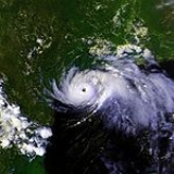
, although conditions favored further development. Due to high pressures surrounding the storm, Alicia was a smaller than normal tropical cyclone; as a result, it produced stronger than normal winds, in comparison to its minimum central pressure. The storm continued slowly to the west-northwest, and by August 17 attained hurricane status, about 160 miles (255 km) southeast of Galveston, Texas. Shortly thereafter, an eye
became visible on radar, as the hurricane executed several small loops. Its slow movement over warm waters, in addition to an anticyclone
becoming established over the hurricane, caused Alicia to undergo rapid deepening
.
At 0600 UTC on August 18, the winds reached 115 mph (185 km/h), just before Alicia made landfall
about 25 mi (40.2 km) southwest of Galveston, Texas. Upon moving ashore, the gale
-force winds extended 125 mi (201.2 km) from the center, and hurricane force winds spread across an area from Freeport
to 60 mi (96.6 km) northeast. Its atmospheric pressure
was 963 mbar
(hPa
; 28.44 inHg
) around the time of landfall, and radar imagery indicated the presence of a rare double-eye structure. Alicia quickly weakened, passing over central Houston with sustained winds of 80 mph (130 km/h). It accelerated toward the northwest, weakening to tropical storm status late on August 18 and to tropical depression status twelve hours later. Tropical Depression Alicia moved into Oklahoma and interacted with an approaching frontal trough
. By 0600 UTC on August 20, Alicia had transitioned into an extratropical cyclone
over northwestern Oklahoma, and by the next day it was no longer identifiable after merging with the trough over eastern Nebraska.
and Grand Isle, Louisiana
issued on August 16. On August 17, a hurricane warning was issued for the coastline from Corpus Christi to Morgan City, Louisiana
, and later for Port Arthur, Texas
southward.
Initially, however, residents did not take the warnings seriously. Galveston Mayor E. Gus Manuel, against the advice of Texas Governor Mark White
, ordered the evacuation of only low-lying areas. As a result, only 10 percent of the population living behind the seawall chose to leave when Alicia came ashore. In contrast, about 30 percent of Galveston's population evacuated the island when Hurricane Allen
threatened the eastern Texas coastline in 1980.
Throughout the day, however, as the increasing winds began to cause damage in Galveston, people grew more concerned. The mayor finally ordered a widespread evacuation of the island after midnight on August 18, but by then, the bridges to the mainland were uncrossable.
area. High gusts were reported throughout Texas, with a maximum gust of 125 mi/h reported on the Coast Guard
cutter
Buttonwood (WLB-306) stationed at the northeastern tip of Galveston Island. Pleasure Pier reported tides of 8.67 ft (2.6 m), with Pier 21 reporting a little over 5.5 ft (1.7 m). Baytown, Texas
reported 10–12 ft (3–3.7 m) tides, and Morgan City reported 12.1 ft (3.7 m), the highest recorded as a result of Alicia. The storm also caused extensive disruption of power services. A Paul Simon
-Art Garfunkel
reunion concert scheduled for the Houston Astrodome was canceled due to the coming storm.
Twenty-three tornadoes were reported in association with Alicia. Fourteen of those were located in the Galveston and Hobby Airport area. The other nine were concentrated around Tyler to Houston, Texas, ranging around F2 on the Fujita scale
.
A major oil spill occurred around Texas City
, and an ocean-going tugboat capsized 50 miles (80.5 km) off the Sabine Pass coast. The Coast Guard Air Station Houston (AIRSTA) weathered Alicia with little damage, and afterwards AIRSTA's helicopters assisted residents with evacuation, supply, and survey flights.
Sixty gallons of water had to be removed from the National Weather Service
(NWS) office in Galveston; this weather office also temporarily lost its radar. Houston suffered billions of dollars in damage. Thousands of glass panes in downtown skyscrapers were shattered by gravel blown off rooftops. Although Alicia was a small Category 3 hurricane, a total of 2,297 dwellings were destroyed by Alicia, with another 3,000+ experiencing major damage. Over ten thousand dwellings had minor damage.
In Galveston, the western beach had its public beach boundary shifted back about 150 ft (45.7 m). About 5 feet (1.5 m) of sand was scoured, leaving beachfront homes in a natural vegetation state. This moved many beachfront homes onto public beach, and the Attorney General's office declared that they were in violation of the Texas Open Beaches Act
and forbade the repair or rebuilding of those homes. The Corps of Engineers
stated that if the Galveston Sea Wall had not been there, that another $100 million (1983 USD; $ USD) in damage could have occurred. Also, if Alicia had been the size of Hurricane Carla
from 1961
, damage could have easily doubled or possibly tripled.
Alicia damaged chemical and petrochemical plants in Houston.
, Iowa
, Minnesota
, Louisiana
and Wisconsin
experienced light rainfall from the remnants of the storm.
, aided with 56 volunteers, interviewed over 16,000 victims, and it was predicted that about 7,000 loan applications would be submitted. The Federal Insurance Agency had closed over 1,318 flood insurance
cases from Alicia's aftermath, however only 782 received final payment.
On September 23 and September 24, 1983, in the wake of Alicia, two subcommittees of the U.S. House of Representatives held hearings in Houston. The hearing on September 23 were to examine the primary issues of the NWS during Alicia, the effectiveness of the NWS in current procedures, and the use of the NWS. The second hearing, which occurred on September 24, was to discuss the damage and recovery efforts during Alicia. During the September 23 hearing, witnesses agreed that the NWS did well before and during the emergency caused by Alicia. NWS forecasters also testified in which they said they gratified themselves that their predictions were well "on target" and that the local emergency plans had worked so well, which saved many lives. Mayor Gus Manuel on Galveston claimed that the NWS did an excellent job during Alicia. He was also very impressed about their landfall predictions on August 17. During the September 24 hearing, evidence was presented which demonstrated the need for improving readiness to cope with disasters, such as Alicia. Mayor Manuel mentioned that his town needed stronger building codes, which were under review.
Due to the severe damage, the name "Alicia" was retired in the spring of 1984, and will never be used again for an Atlantic hurricane. It was replaced with "Allison" for the 1989 season
. Coincidentally, in 2001
the name "Allison" was retired after striking the same area as Alicia.
Tropical cyclone
A tropical cyclone is a storm system characterized by a large low-pressure center and numerous thunderstorms that produce strong winds and heavy rain. Tropical cyclones strengthen when water evaporated from the ocean is released as the saturated air rises, resulting in condensation of water vapor...
in the Atlantic since Hurricane Agnes
Hurricane Agnes
Hurricane Agnes was the first tropical storm and first hurricane of the 1972 Atlantic hurricane season. A rare June hurricane, it made landfall on the Florida Panhandle before moving northeastward and ravaging the Mid-Atlantic region as a tropical storm...
in 1972
1972 Atlantic hurricane season
The 1972 Atlantic hurricane season officially began on June 1, 1972, and lasted until November 30, 1972. These dates conventionally delimit the period of each year when most tropical cyclones form in the Atlantic basin. A strong El Niño kept hurricane activity at a minimum, and in fact the season...
. Alicia was the third depression, the first tropical storm, and the only major hurricane of the 1983 Atlantic hurricane season
1983 Atlantic hurricane season
The 1983 Atlantic hurricane season was the least active Atlantic hurricane season in 53 years, with only four tropical storms forming. The season officially began on June 1, 1983, and lasted until November 30, 1983. These dates conventionally delimit the period of each year when most storms...
. It struck Galveston and Houston, Texas
Texas
Texas is the second largest U.S. state by both area and population, and the largest state by area in the contiguous United States.The name, based on the Caddo word "Tejas" meaning "friends" or "allies", was applied by the Spanish to the Caddo themselves and to the region of their settlement in...
directly, causing $2.6 billion (1983 USD
United States dollar
The United States dollar , also referred to as the American dollar, is the official currency of the United States of America. It is divided into 100 smaller units called cents or pennies....
; $ USD) in damage and killing 21 people; this made it the worst Texas hurricane since Hurricane Carla
Hurricane Carla
Hurricane Carla was one of two Category 5 tropical cyclones during the 1961 Atlantic hurricane season. It struck the Texas coast as a Category 4 hurricane, becoming one of the most powerful storms to ever strike the United States. Hurricane Carla was the second most intense storm to ever...
in 1961
1961 Atlantic hurricane season
The 1961 Atlantic hurricane season officially began on June 15, 1961, and lasted until November 15, 1961. These dates conventionally delimit the period of each year when most tropical cyclones form in the Atlantic basin. The season had seven major hurricanes, the second highest number on...
. In addition, Alicia was the first billion-dollar tropical cyclone in Texas history.
Hurricane Alicia was the first hurricane to hit the United States
United States
The United States of America is a federal constitutional republic comprising fifty states and a federal district...
mainland since Hurricane Allen
Hurricane Allen
Hurricane Allen was the first and strongest hurricane of the 1980 Atlantic hurricane season. It was one of the strongest hurricanes in recorded history, one of the few hurricanes to reach Category 5 status on the Saffir-Simpson Hurricane Scale on three separate occasions, and spent more time...
in August 1980. The time between the two storms totaled three years and eight days (1,103 days). Hurricane Alicia became the last major hurricane (Category 3 or higher) to strike Texas until the stronger Hurricane Bret in 1999
Hurricane Bret (1999)
Hurricane Bret was the first of five Category 4 hurricanes that developed during the 1999 Atlantic hurricane season and the first tropical cyclone since Hurricane Jerry in 1989 to make landfall in Texas at hurricane intensity. Forming from a tropical wave on August 18, Bret slowly...
made landfall. Alicia was the first storm for which the National Hurricane Center
National Hurricane Center
The National Hurricane Center , located at Florida International University in Miami, Florida, is the division of the National Weather Service responsible for tracking and predicting weather systems within the tropics between the Prime Meridian and the 140th meridian west poleward to the 30th...
issued landfall probabilities.
Hurricane Alicia was notable for the delayed post storm evacuation of Galveston Island (since the eye of the storm traveled the evacuation route up Interstate 45
Interstate 45
Interstate 45 is an intrastate Interstate Highway located entirely within the U.S. state of Texas. It connects the cities of Dallas and Houston, continuing southeast from Houston to Galveston over the Galveston Causeway to the Gulf of Mexico...
from Galveston to Houston). The hurricane was also notable for the shattering of many windows in downtown Houston by loose gravel from the roofs of new skyscrapers and by other debris, prompting changes to rooftop construction codes.
Meteorological history
The origins of Hurricane Alicia were from a cold frontCold front
A cold front is defined as the leading edge of a cooler mass of air, replacing a warmer mass of air.-Development of cold front:The cooler and denser air wedges under the less-dense warmer air, lifting it...
that extended from New England
New England
New England is a region in the northeastern corner of the United States consisting of the six states of Maine, New Hampshire, Vermont, Massachusetts, Rhode Island, and Connecticut...
through the central Gulf of Mexico
Gulf of Mexico
The Gulf of Mexico is a partially landlocked ocean basin largely surrounded by the North American continent and the island of Cuba. It is bounded on the northeast, north and northwest by the Gulf Coast of the United States, on the southwest and south by Mexico, and on the southeast by Cuba. In...
. On August 14, mesoscale
Mesoscale meteorology
Mesoscale meteorology is the study of weather systems smaller than synoptic scale systems but larger than microscale and storm-scale cumulus systems. Horizontal dimensions generally range from around 5 kilometers to several hundred kilometers...
low-pressure area developed off the Alabama and Mississippi coastlines. Around 0100 UTC
Coordinated Universal Time
Coordinated Universal Time is the primary time standard by which the world regulates clocks and time. It is one of several closely related successors to Greenwich Mean Time. Computer servers, online services and other entities that rely on having a universally accepted time use UTC for that purpose...
on August 15, the low had maintained convection, or area of thunderstorms, for 12 hours, as well as a circulation
Atmospheric circulation
Atmospheric circulation is the large-scale movement of air, and the means by which thermal energy is distributed on the surface of the Earth....
for six hours; as a result, the National Hurricane Center
National Hurricane Center
The National Hurricane Center , located at Florida International University in Miami, Florida, is the division of the National Weather Service responsible for tracking and predicting weather systems within the tropics between the Prime Meridian and the 140th meridian west poleward to the 30th...
(NHC) began issuing Dvorak classifications
Dvorak technique
The Dvorak technique is a widely used system to subjectively estimate tropical cyclone intensity based solely on visible and infrared satellite images. Several agencies issue Dvorak intensity numbers for cyclones of sufficient intensity...
on the system. By a few hours later, the deep convection became organized in the circulation's southern semicircle, which prompted a Hurricane Hunters
Hurricane Hunters
The Hurricane Hunters are aircraft that fly into tropical cyclones in the North Atlantic Ocean and Northeastern Pacific Ocean for the specific purpose of directly measuring weather data in and around those storms. In the United States, the Air Force, Navy, and NOAA units have all participated in...
flight into the system. At 1200 UTC that day, the system developed
Tropical cyclogenesis
Tropical cyclogenesis is the term that describes the development and strengthening of a tropical cyclone in the atmosphere. The mechanisms through which tropical cyclogenesis occurs are distinctly different from those through which mid-latitude cyclogenesis occurs...
into Tropical Depression Three about 350 miles (560 km) south-southwest of the Mississippi River Delta
Mississippi River Delta
The Mississippi River Delta is the modern area of land built up by alluvium deposited by the Mississippi River as it slows down and enters the Gulf of Mexico...
. A few hours later, the Hurricane Hunters confirmed its development. Such development along the tail end of a cold front is more typical earlier or later in the hurricane season.
After becoming a tropical cyclone, the depression was moving slowly westward, due to a ridge
Ridge (meteorology)
A ridge is an elongated region of relatively high atmospheric pressure, the opposite of a trough....
to its north. A Hurricane Hunters flight late on August 15 reported that the depression reached winds of 50 mph (80 km/h); as a result, the NHC upgraded the cyclone to Tropical Storm Alicia. At the time of its upgrade, the storm was located in an area of higher than normal atmospheric pressure
Atmospheric pressure
Atmospheric pressure is the force per unit area exerted into a surface by the weight of air above that surface in the atmosphere of Earth . In most circumstances atmospheric pressure is closely approximated by the hydrostatic pressure caused by the weight of air above the measurement point...
, although conditions favored further development. Due to high pressures surrounding the storm, Alicia was a smaller than normal tropical cyclone; as a result, it produced stronger than normal winds, in comparison to its minimum central pressure. The storm continued slowly to the west-northwest, and by August 17 attained hurricane status, about 160 miles (255 km) southeast of Galveston, Texas. Shortly thereafter, an eye
Eye (cyclone)
The eye is a region of mostly calm weather found at the center of strong tropical cyclones. The eye of a storm is a roughly circular area and typically 30–65 km in diameter. It is surrounded by the eyewall, a ring of towering thunderstorms where the second most severe weather of a cyclone...
became visible on radar, as the hurricane executed several small loops. Its slow movement over warm waters, in addition to an anticyclone
Anticyclone
An anticyclone is a weather phenomenon defined by the United States' National Weather Service's glossary as "[a] large-scale circulation of winds around a central region of high atmospheric pressure, clockwise in the Northern Hemisphere, counterclockwise in the Southern Hemisphere"...
becoming established over the hurricane, caused Alicia to undergo rapid deepening
Rapid deepening
Rapid deepening, also known as rapid intensification, is a meteorological condition that occurs when the minimum sea-level atmospheric pressure of a tropical cyclone decreases drastically in a short period of time. The National Weather Service describes rapid deepening as a decrease of...
.
At 0600 UTC on August 18, the winds reached 115 mph (185 km/h), just before Alicia made landfall
Landfall (meteorology)
Landfall is the event of a tropical cyclone or a waterspout coming onto land after being over water. When a waterspout makes landfall it is reclassified as a tornado, which can then cause damage inland...
about 25 mi (40.2 km) southwest of Galveston, Texas. Upon moving ashore, the gale
Gale
A gale is a very strong wind. There are conflicting definitions of how strong a wind must be to be considered a gale. The U.S. government's National Weather Service defines a gale as 34–47 knots of sustained surface winds. Forecasters typically issue gale warnings when winds of this strength are...
-force winds extended 125 mi (201.2 km) from the center, and hurricane force winds spread across an area from Freeport
Freeport, Texas
Freeport is a city in Brazoria County, Texas within the Houston–Sugar Land–Baytown metropolitan area and is situated in Southeast Texas. As of the 2000 U.S...
to 60 mi (96.6 km) northeast. Its atmospheric pressure
Atmospheric pressure
Atmospheric pressure is the force per unit area exerted into a surface by the weight of air above that surface in the atmosphere of Earth . In most circumstances atmospheric pressure is closely approximated by the hydrostatic pressure caused by the weight of air above the measurement point...
was 963 mbar
Bar (unit)
The bar is a unit of pressure equal to 100 kilopascals, and roughly equal to the atmospheric pressure on Earth at sea level. Other units derived from the bar are the megabar , kilobar , decibar , centibar , and millibar...
(hPa
Pascal (unit)
The pascal is the SI derived unit of pressure, internal pressure, stress, Young's modulus and tensile strength, named after the French mathematician, physicist, inventor, writer, and philosopher Blaise Pascal. It is a measure of force per unit area, defined as one newton per square metre...
; 28.44 inHg
Inch of mercury
Inches of mercury, ' is a unit of measurement for pressure. It is still widely used for barometric pressure in weather reports, refrigeration and aviation in the United States, but is seldom used elsewhere....
) around the time of landfall, and radar imagery indicated the presence of a rare double-eye structure. Alicia quickly weakened, passing over central Houston with sustained winds of 80 mph (130 km/h). It accelerated toward the northwest, weakening to tropical storm status late on August 18 and to tropical depression status twelve hours later. Tropical Depression Alicia moved into Oklahoma and interacted with an approaching frontal trough
Trough (meteorology)
A trough is an elongated region of relatively low atmospheric pressure, often associated with fronts.Unlike fronts, there is not a universal symbol for a trough on a weather chart. The weather charts in some countries or regions mark troughs by a line. In the United States, a trough may be marked...
. By 0600 UTC on August 20, Alicia had transitioned into an extratropical cyclone
Extratropical cyclone
Extratropical cyclones, sometimes called mid-latitude cyclones or wave cyclones, are a group of cyclones defined as synoptic scale low pressure weather systems that occur in the middle latitudes of the Earth having neither tropical nor polar characteristics, and are connected with fronts and...
over northwestern Oklahoma, and by the next day it was no longer identifiable after merging with the trough over eastern Nebraska.
Preparations
Several watches and warnings were issued in association with Alicia. The first ones were a gale warning and a hurricane watch for the area between Corpus Christi, TexasCorpus Christi, Texas
Corpus Christi is a coastal city in the South Texas region of the U.S. state of Texas. The county seat of Nueces County, it also extends into Aransas, Kleberg, and San Patricio counties. The MSA population in 2008 was 416,376. The population was 305,215 at the 2010 census making it the...
and Grand Isle, Louisiana
Grand Isle, Louisiana
Grand Isle is a town in Jefferson Parish, Louisiana, located on a barrier island of the same name in the Gulf of Mexico. The island is at the mouth of Barataria Bay where it meets the gulf. As of the 2000 census, the town population was 1,541; during summers, the population sometimes increases to...
issued on August 16. On August 17, a hurricane warning was issued for the coastline from Corpus Christi to Morgan City, Louisiana
Morgan City, Louisiana
Morgan City is a city in St. Martin and St. Mary parishes in the U.S. state of Louisiana. The population was 12,404 at the 2010 census....
, and later for Port Arthur, Texas
Port Arthur, Texas
-Demographics:As of the 2000 census, there were 57,755 people, 21,839 households, and 14,675 families residing in the city. The population density was 696.5 people per square mile . There were 24,713 housing units at an average density of 298.0 per square mile...
southward.
Initially, however, residents did not take the warnings seriously. Galveston Mayor E. Gus Manuel, against the advice of Texas Governor Mark White
Mark White
Mark Wells White is an American lawyer, who served as the 43rd Governor of Texas from January 18,1983-January 20,1987.-Biography:...
, ordered the evacuation of only low-lying areas. As a result, only 10 percent of the population living behind the seawall chose to leave when Alicia came ashore. In contrast, about 30 percent of Galveston's population evacuated the island when Hurricane Allen
Hurricane Allen
Hurricane Allen was the first and strongest hurricane of the 1980 Atlantic hurricane season. It was one of the strongest hurricanes in recorded history, one of the few hurricanes to reach Category 5 status on the Saffir-Simpson Hurricane Scale on three separate occasions, and spent more time...
threatened the eastern Texas coastline in 1980.
Throughout the day, however, as the increasing winds began to cause damage in Galveston, people grew more concerned. The mayor finally ordered a widespread evacuation of the island after midnight on August 18, but by then, the bridges to the mainland were uncrossable.
Texas
Galveston reported 7+3/4 in of rain, Liberty reported 9+1/2 in of rain, and Greens Bayou reported almost 10 in (254 mm). Centerville reported over 8 inches (203.2 mm), with Normangee and Noxia reporting over 7 in (177.8 mm). Maximum rainfall in the Houston area in Harris County was about 10–11 in (254–279.4 mm), while 8 in (203.2 mm) of rain was reported in Leon County and 9 in (228.6 mm) in the Sabine RiverSabine River (Texas-Louisiana)
The Sabine River is a river, long, in the U.S. states of Texas and Louisiana. In its lower course, it forms part of the boundary between the two states and empties into Sabine Lake, an estuary of the Gulf of Mexico. The river formed part of the United States-Mexican international boundary during...
area. High gusts were reported throughout Texas, with a maximum gust of 125 mi/h reported on the Coast Guard
United States Coast Guard
The United States Coast Guard is a branch of the United States Armed Forces and one of the seven U.S. uniformed services. The Coast Guard is a maritime, military, multi-mission service unique among the military branches for having a maritime law enforcement mission and a federal regulatory agency...
cutter
United States Coast Guard Cutter
Cutter is the term used by the United States Coast Guard for its commissioned vessels. A Cutter is or greater in length, has a permanently assigned crew, and has accommodations for the crew to live aboard...
Buttonwood (WLB-306) stationed at the northeastern tip of Galveston Island. Pleasure Pier reported tides of 8.67 ft (2.6 m), with Pier 21 reporting a little over 5.5 ft (1.7 m). Baytown, Texas
Baytown, Texas
Baytown is a city within Harris County and partially in Chambers County in the Gulf Coast region of the U.S. state of Texas. Located within the Houston–Sugar Land–Baytown metropolitan area, it lies along both State Highway 146 and Interstate 10. As of 2010, Baytown had an population of 71,802...
reported 10–12 ft (3–3.7 m) tides, and Morgan City reported 12.1 ft (3.7 m), the highest recorded as a result of Alicia. The storm also caused extensive disruption of power services. A Paul Simon
Paul Simon
Paul Frederic Simon is an American singer-songwriter and guitarist.Simon is best known for his success, beginning in 1965, as part of the duo Simon & Garfunkel, with musical partner Art Garfunkel. Simon wrote most of the pair's songs, including three that reached number one on the US singles...
-Art Garfunkel
Art Garfunkel
Arthur Ira "Art" Garfunkel is an American singer-songwriter, poet, and actor, best known as being a member of the folk duo Simon & Garfunkel...
reunion concert scheduled for the Houston Astrodome was canceled due to the coming storm.
Twenty-three tornadoes were reported in association with Alicia. Fourteen of those were located in the Galveston and Hobby Airport area. The other nine were concentrated around Tyler to Houston, Texas, ranging around F2 on the Fujita scale
Fujita scale
The Fujita scale , or Fujita-Pearson scale, is a scale for rating tornado intensity, based primarily on the damage tornadoes inflict on human-built structures and vegetation...
.
A major oil spill occurred around Texas City
Texas City, Texas
Texas City is a city in Chambers and Galveston counties in the U.S. state of Texas. The population was 41,521 at the 2000 census. It is a part of the Houston–Sugar Land–Baytown, Texas Metropolitan Statistical Area.-History:...
, and an ocean-going tugboat capsized 50 miles (80.5 km) off the Sabine Pass coast. The Coast Guard Air Station Houston (AIRSTA) weathered Alicia with little damage, and afterwards AIRSTA's helicopters assisted residents with evacuation, supply, and survey flights.
Sixty gallons of water had to be removed from the National Weather Service
National Weather Service
The National Weather Service , once known as the Weather Bureau, is one of the six scientific agencies that make up the National Oceanic and Atmospheric Administration of the United States government...
(NWS) office in Galveston; this weather office also temporarily lost its radar. Houston suffered billions of dollars in damage. Thousands of glass panes in downtown skyscrapers were shattered by gravel blown off rooftops. Although Alicia was a small Category 3 hurricane, a total of 2,297 dwellings were destroyed by Alicia, with another 3,000+ experiencing major damage. Over ten thousand dwellings had minor damage.
In Galveston, the western beach had its public beach boundary shifted back about 150 ft (45.7 m). About 5 feet (1.5 m) of sand was scoured, leaving beachfront homes in a natural vegetation state. This moved many beachfront homes onto public beach, and the Attorney General's office declared that they were in violation of the Texas Open Beaches Act
Texas Open Beaches Act
The Texas Open Beaches Act is a U.S. state of Texas law, passed in 1959 and amended in 1991, which guarantees free public access to beaches on the Gulf of Mexico:...
and forbade the repair or rebuilding of those homes. The Corps of Engineers
United States Army Corps of Engineers
The United States Army Corps of Engineers is a federal agency and a major Army command made up of some 38,000 civilian and military personnel, making it the world's largest public engineering, design and construction management agency...
stated that if the Galveston Sea Wall had not been there, that another $100 million (1983 USD; $ USD) in damage could have occurred. Also, if Alicia had been the size of Hurricane Carla
Hurricane Carla
Hurricane Carla was one of two Category 5 tropical cyclones during the 1961 Atlantic hurricane season. It struck the Texas coast as a Category 4 hurricane, becoming one of the most powerful storms to ever strike the United States. Hurricane Carla was the second most intense storm to ever...
from 1961
1961 Atlantic hurricane season
The 1961 Atlantic hurricane season officially began on June 15, 1961, and lasted until November 15, 1961. These dates conventionally delimit the period of each year when most tropical cyclones form in the Atlantic basin. The season had seven major hurricanes, the second highest number on...
, damage could have easily doubled or possibly tripled.
Alicia damaged chemical and petrochemical plants in Houston.
Elsewhere
As Alicia progressed northward, it produced heavy precipitation in several other areas. In Oklahoma, the rain amounted to 5.51 in (140 mm) in south-central portions of the state. Parts of Kansas and Nebraska received 1 to 3 in (25.4 to 76.2 mm) of rainfall. Other states, including MichiganMichigan
Michigan is a U.S. state located in the Great Lakes Region of the United States of America. The name Michigan is the French form of the Ojibwa word mishigamaa, meaning "large water" or "large lake"....
, Iowa
Iowa
Iowa is a state located in the Midwestern United States, an area often referred to as the "American Heartland". It derives its name from the Ioway people, one of the many American Indian tribes that occupied the state at the time of European exploration. Iowa was a part of the French colony of New...
, Minnesota
Minnesota
Minnesota is a U.S. state located in the Midwestern United States. The twelfth largest state of the U.S., it is the twenty-first most populous, with 5.3 million residents. Minnesota was carved out of the eastern half of the Minnesota Territory and admitted to the Union as the thirty-second state...
, Louisiana
Louisiana
Louisiana is a state located in the southern region of the United States of America. Its capital is Baton Rouge and largest city is New Orleans. Louisiana is the only state in the U.S. with political subdivisions termed parishes, which are local governments equivalent to counties...
and Wisconsin
Wisconsin
Wisconsin is a U.S. state located in the north-central United States and is part of the Midwest. It is bordered by Minnesota to the west, Iowa to the southwest, Illinois to the south, Lake Michigan to the east, Michigan to the northeast, and Lake Superior to the north. Wisconsin's capital is...
experienced light rainfall from the remnants of the storm.
Aftermath
The Red Cross provided food and shelter to 63,000 people in the hurricane's wake, costing about $166 million (1983 USD; $ USD). FEMA gave out $32 million (1983 USD; $ USD) to Alicia's victims and local governments; $23 million (1983 USD; $ USD) of that was for picking up debris spread after the storm. More than 16,000 people sought help from FEMA's disaster service centers. The Small Business AdministrationSmall Business Administration
The Small Business Administration is a United States government agency that provides support to entrepreneurs and small businesses. The mission of the Small Business Administration is "to maintain and strengthen the nation's economy by enabling the establishment and viability of small businesses...
, aided with 56 volunteers, interviewed over 16,000 victims, and it was predicted that about 7,000 loan applications would be submitted. The Federal Insurance Agency had closed over 1,318 flood insurance
Flood insurance
Flood insurance denotes the specific insurance coverage against property loss from flooding. To determine risk factors for specific properties, insurers will often refer to topographical maps that denote lowlands, floodplains and floodways that are susceptible to flooding.-Hidden floods:Nationwide,...
cases from Alicia's aftermath, however only 782 received final payment.
On September 23 and September 24, 1983, in the wake of Alicia, two subcommittees of the U.S. House of Representatives held hearings in Houston. The hearing on September 23 were to examine the primary issues of the NWS during Alicia, the effectiveness of the NWS in current procedures, and the use of the NWS. The second hearing, which occurred on September 24, was to discuss the damage and recovery efforts during Alicia. During the September 23 hearing, witnesses agreed that the NWS did well before and during the emergency caused by Alicia. NWS forecasters also testified in which they said they gratified themselves that their predictions were well "on target" and that the local emergency plans had worked so well, which saved many lives. Mayor Gus Manuel on Galveston claimed that the NWS did an excellent job during Alicia. He was also very impressed about their landfall predictions on August 17. During the September 24 hearing, evidence was presented which demonstrated the need for improving readiness to cope with disasters, such as Alicia. Mayor Manuel mentioned that his town needed stronger building codes, which were under review.
Due to the severe damage, the name "Alicia" was retired in the spring of 1984, and will never be used again for an Atlantic hurricane. It was replaced with "Allison" for the 1989 season
1989 Atlantic hurricane season
The 1989 Atlantic hurricane season was an active season that produced fifteen tropical cyclones, eleven named storms, seven hurricanes, and two major hurricanes. The season was officially designated from June 1, 1989, to November 30, 1989, dates which conventionally...
. Coincidentally, in 2001
Tropical Storm Allison
Tropical Storm Allison was a tropical storm that devastated southeast Texas in June of the 2001 Atlantic hurricane season. The first storm of the season, Allison lasted an unusually long period of time for a June storm, remaining tropical or subtropical for 15 days...
the name "Allison" was retired after striking the same area as Alicia.
See also
- List of Texas hurricanes
- List of retired Atlantic hurricane names
- Timeline of the 1983 Atlantic hurricane seasonTimeline of the 1983 Atlantic hurricane seasonThe 1983 Atlantic hurricane season was the least active Atlantic hurricane season in 53 years, during which four tropical cyclones formed. The season officially began on June 1, 1983 and ended on November 30, dates which conventionally limit the period of each year when tropical cyclones...