
1972 Atlantic hurricane season
Encyclopedia
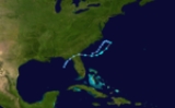
The 1972 Atlantic hurricane season officially began on June 1, 1972, and lasted until November 30, 1972. These dates conventionally delimit the period of each year when most tropical cyclone
s form in the Atlantic basin
. A strong El Niño kept hurricane activity at a minimum, and in fact the season
was one of the quietest since the beginning of regular hurricane reconnaissance in 1944. It was also one of only four hurricane seasons since 1944 to have no major hurricanes (the other years being the 1968 season
, the 1986 season
, and the 1994 season
).
Although a very inactive season, 1972 brought one of the deadliest and most expensive hurricanes to strike the United States
, Hurricane Agnes
. Agnes was a weak but large storm that made landfall at the Florida
panhandle and then followed the east coast northward. It killed 122 and caused $2.1 billion (1972 dollars) in damage, mostly due to flooding in Pennsylvania
and New York
.
coast. As the low moved northeastward, it warmed a little, and became Subtropical Depression One. It turned sharply southward on May 26 due to a building ridge of high pressure
. The same day it became Subtropical Storm Alpha, and it moved toward the Georgia
coast. After reaching its peak of 70 mi/h, Alpha weakened, but managed to hit near Brunswick, Georgia
as a 45 mi/h subtropical storm. Alpha dissipated over the northeastern Gulf of Mexico
on May 29.
Alpha was the first named subtropical storm.
hurricane that formed over the Yucatán Peninsula
on June 14. It moved northward, reaching and maintaining hurricane intensity prior to landfall on the Florida Panhandle
. Agnes reintensified over North Carolina
, and in combination with an extratropical low to its west, brought very heavy rains to the Mid-Atlantic
. Agnes dissipated on June 23 after causing over $3 billion in damage (1970 US dollars). It held the record for most expensive hurricane in American history until Hurricane Frederic
surpassed it in 1979.
. Initially a small cyclone, only 30–40 miles in diameter, the depression grew as it strengthened and moved eastward, designated Subtropical Storm Bravo on August 24. On August 25, the broad wind field became more compact, and it was named Tropical Storm Betty. On August 27 it became a hurricane, and on August 28 Betty reached its peak of 100 mph (Category 2 intensity), the highest winds of the 1972 season. Building high pressure to its east forced Betty to the southwest, and over the next 3 days it executed a loop, but cooler waters and upper level shear turned the system extratropical on September 1.
, Carrie began to re-intensify. As a result, Carrie attained its peak winds of 70 mph (110 km/h) just prior to transitioning into an extratropical cyclone
on September 3. The extratropical cyclone continued northeastward, and struck eastern Maine
on September 4. By the following day, the extratropical cyclone dissipated over the Gulf of Saint Lawrence
.
As Carrie passed Cape Cod
, heavy rainfall occurred in that portion of Massachusetts
, peaking at 12.5 in (317.5 mm) in Tashmoo. In addition, Carrie produced tropical storm and hurricane force winds in Massachusetts, Maine
, and Rhode Island
. In the wake of Carrie, $1.78 million (1972 USD; $ USD) in damage and four fatalities were reported throughout New England
.
forced Dawn westward, then southeastward, where Dawn became a 50 mi/h tropical storm. It continued to weaken as it approached the Georgia and South Carolina
coasts, and it finally dissipated on September 14, causing little damage over land.
for these storms. Names that were not assigned are marked in .
Tropical cyclone
A tropical cyclone is a storm system characterized by a large low-pressure center and numerous thunderstorms that produce strong winds and heavy rain. Tropical cyclones strengthen when water evaporated from the ocean is released as the saturated air rises, resulting in condensation of water vapor...
s form in the Atlantic basin
Atlantic Basin
The Atlantic Basin is the Atlantic Ocean.Atlantic Basin may also refer to:* Atlantic Basin Iron Works, an ironworks that operated in Brooklyn, New York, in the early to mid-20th century...
. A strong El Niño kept hurricane activity at a minimum, and in fact the season
Atlantic hurricane season
The Atlantic hurricane season is the period in a year when hurricanes usually form in the Atlantic Ocean. Tropical cyclones in the North Atlantic are called hurricanes, tropical storms, or tropical depressions. In addition, there have been several storms over the years that have not been fully...
was one of the quietest since the beginning of regular hurricane reconnaissance in 1944. It was also one of only four hurricane seasons since 1944 to have no major hurricanes (the other years being the 1968 season
1968 Atlantic hurricane season
The 1968 Atlantic hurricane season officially began on June 1, 1968, and lasted until November 30, 1968. These dates conventionally delimit the period of each year when most tropical cyclones form in the Atlantic basin....
, the 1986 season
1986 Atlantic hurricane season
The 1986 Atlantic hurricane season officially began on June 1, 1986, and lasted until November 30, 1986. These dates conventionally delimit the period of each year when most tropical cyclones form in the Atlantic basin...
, and the 1994 season
1994 Atlantic hurricane season
The 1994 Atlantic hurricane seasonofficially began June 1, 1994, and officially ended November 30, 1994. These dates conventionally delimit the period of each year when most tropical cyclones form in the Atlantic basin....
).
Although a very inactive season, 1972 brought one of the deadliest and most expensive hurricanes to strike the United States
United States
The United States of America is a federal constitutional republic comprising fifty states and a federal district...
, Hurricane Agnes
Hurricane Agnes
Hurricane Agnes was the first tropical storm and first hurricane of the 1972 Atlantic hurricane season. A rare June hurricane, it made landfall on the Florida Panhandle before moving northeastward and ravaging the Mid-Atlantic region as a tropical storm...
. Agnes was a weak but large storm that made landfall at the Florida
Florida
Florida is a state in the southeastern United States, located on the nation's Atlantic and Gulf coasts. It is bordered to the west by the Gulf of Mexico, to the north by Alabama and Georgia and to the east by the Atlantic Ocean. With a population of 18,801,310 as measured by the 2010 census, it...
panhandle and then followed the east coast northward. It killed 122 and caused $2.1 billion (1972 dollars) in damage, mostly due to flooding in Pennsylvania
Pennsylvania
The Commonwealth of Pennsylvania is a U.S. state that is located in the Northeastern and Mid-Atlantic regions of the United States. The state borders Delaware and Maryland to the south, West Virginia to the southwest, Ohio to the west, New York and Ontario, Canada, to the north, and New Jersey to...
and New York
New York
New York is a state in the Northeastern region of the United States. It is the nation's third most populous state. New York is bordered by New Jersey and Pennsylvania to the south, and by Connecticut, Massachusetts and Vermont to the east...
.
Subtropical Storm Alpha
Subtropical Storm Alpha developed from a cold-core (extratropical) low in late May off the FloridaFlorida
Florida is a state in the southeastern United States, located on the nation's Atlantic and Gulf coasts. It is bordered to the west by the Gulf of Mexico, to the north by Alabama and Georgia and to the east by the Atlantic Ocean. With a population of 18,801,310 as measured by the 2010 census, it...
coast. As the low moved northeastward, it warmed a little, and became Subtropical Depression One. It turned sharply southward on May 26 due to a building ridge of high pressure
High pressure
High pressure in science and engineering is studying the effects of high pressure on materials and the design and construction of devices, such as a diamond anvil cell, which can create high pressure...
. The same day it became Subtropical Storm Alpha, and it moved toward the Georgia
Georgia (U.S. state)
Georgia is a state located in the southeastern United States. It was established in 1732, the last of the original Thirteen Colonies. The state is named after King George II of Great Britain. Georgia was the fourth state to ratify the United States Constitution, on January 2, 1788...
coast. After reaching its peak of 70 mi/h, Alpha weakened, but managed to hit near Brunswick, Georgia
Brunswick, Georgia
Brunswick is the major urban and economic center in southeastern Georgia in the United States. The municipality is located on a harbor near the Atlantic Ocean, approximately 30 miles north of Florida and 70 miles south of South Carolina. Brunswick is bordered on the east by the Atlantic...
as a 45 mi/h subtropical storm. Alpha dissipated over the northeastern Gulf of Mexico
Gulf of Mexico
The Gulf of Mexico is a partially landlocked ocean basin largely surrounded by the North American continent and the island of Cuba. It is bounded on the northeast, north and northwest by the Gulf Coast of the United States, on the southwest and south by Mexico, and on the southeast by Cuba. In...
on May 29.
Alpha was the first named subtropical storm.
Hurricane Agnes
Hurricane Agnes was a large June Gulf of MexicoGulf of Mexico
The Gulf of Mexico is a partially landlocked ocean basin largely surrounded by the North American continent and the island of Cuba. It is bounded on the northeast, north and northwest by the Gulf Coast of the United States, on the southwest and south by Mexico, and on the southeast by Cuba. In...
hurricane that formed over the Yucatán Peninsula
Yucatán Peninsula
The Yucatán Peninsula, in southeastern Mexico, separates the Caribbean Sea from the Gulf of Mexico, with the northern coastline on the Yucatán Channel...
on June 14. It moved northward, reaching and maintaining hurricane intensity prior to landfall on the Florida Panhandle
Florida Panhandle
The Florida Panhandle, an informal, unofficial term for the northwestern part of Florida, is a strip of land roughly 200 miles long and 50 to 100 miles wide , lying between Alabama on the north and the west, Georgia also on the north, and the Gulf of Mexico to the south. Its eastern boundary is...
. Agnes reintensified over North Carolina
North Carolina
North Carolina is a state located in the southeastern United States. The state borders South Carolina and Georgia to the south, Tennessee to the west and Virginia to the north. North Carolina contains 100 counties. Its capital is Raleigh, and its largest city is Charlotte...
, and in combination with an extratropical low to its west, brought very heavy rains to the Mid-Atlantic
Mid-Atlantic States
The Mid-Atlantic states, also called middle Atlantic states or simply the mid Atlantic, form a region of the United States generally located between New England and the South...
. Agnes dissipated on June 23 after causing over $3 billion in damage (1970 US dollars). It held the record for most expensive hurricane in American history until Hurricane Frederic
Hurricane Frederic
Hurricane Frederic was the sixth tropical cyclone, third hurricane and second major hurricane of the 1979 Atlantic hurricane season. Frederic was the costliest hurricane to ever hit the U.S. Gulf Coast at that particular time...
surpassed it in 1979.
Hurricane Betty
The precursor of Hurricane Betty was a subtropical depression that developed from a decaying cold front on August 22, located 200 miles (321.9 km) north-northeast of BermudaBermuda
Bermuda is a British overseas territory in the North Atlantic Ocean. Located off the east coast of the United States, its nearest landmass is Cape Hatteras, North Carolina, about to the west-northwest. It is about south of Halifax, Nova Scotia, Canada, and northeast of Miami, Florida...
. Initially a small cyclone, only 30–40 miles in diameter, the depression grew as it strengthened and moved eastward, designated Subtropical Storm Bravo on August 24. On August 25, the broad wind field became more compact, and it was named Tropical Storm Betty. On August 27 it became a hurricane, and on August 28 Betty reached its peak of 100 mph (Category 2 intensity), the highest winds of the 1972 season. Building high pressure to its east forced Betty to the southwest, and over the next 3 days it executed a loop, but cooler waters and upper level shear turned the system extratropical on September 1.
Tropical Storm Carrie
A complex system combining a tropical wave and an upper level low led to the formation of a tropical depression east of Florida on August 29. It managed to become a tropical storm on August 31 and reached initial peak winds of 60 mph (95 km/h) later that day. However, upper-level winds increased, causing Carrie to weaken to a minimal tropical storm by September 2. Due to baroclinic processesBaroclinity
In fluid dynamics, the baroclinity of a stratified fluid is a measure of how misaligned the gradient of pressure is from the gradient of density in a fluid...
, Carrie began to re-intensify. As a result, Carrie attained its peak winds of 70 mph (110 km/h) just prior to transitioning into an extratropical cyclone
Extratropical cyclone
Extratropical cyclones, sometimes called mid-latitude cyclones or wave cyclones, are a group of cyclones defined as synoptic scale low pressure weather systems that occur in the middle latitudes of the Earth having neither tropical nor polar characteristics, and are connected with fronts and...
on September 3. The extratropical cyclone continued northeastward, and struck eastern Maine
Maine
Maine is a state in the New England region of the northeastern United States, bordered by the Atlantic Ocean to the east and south, New Hampshire to the west, and the Canadian provinces of Quebec to the northwest and New Brunswick to the northeast. Maine is both the northernmost and easternmost...
on September 4. By the following day, the extratropical cyclone dissipated over the Gulf of Saint Lawrence
Gulf of Saint Lawrence
The Gulf of Saint Lawrence , the world's largest estuary, is the outlet of North America's Great Lakes via the Saint Lawrence River into the Atlantic Ocean...
.
As Carrie passed Cape Cod
Cape Cod
Cape Cod, often referred to locally as simply the Cape, is a cape in the easternmost portion of the state of Massachusetts, in the Northeastern United States...
, heavy rainfall occurred in that portion of Massachusetts
Massachusetts
The Commonwealth of Massachusetts is a state in the New England region of the northeastern United States of America. It is bordered by Rhode Island and Connecticut to the south, New York to the west, and Vermont and New Hampshire to the north; at its east lies the Atlantic Ocean. As of the 2010...
, peaking at 12.5 in (317.5 mm) in Tashmoo. In addition, Carrie produced tropical storm and hurricane force winds in Massachusetts, Maine
Maine
Maine is a state in the New England region of the northeastern United States, bordered by the Atlantic Ocean to the east and south, New Hampshire to the west, and the Canadian provinces of Quebec to the northwest and New Brunswick to the northeast. Maine is both the northernmost and easternmost...
, and Rhode Island
Rhode Island
The state of Rhode Island and Providence Plantations, more commonly referred to as Rhode Island , is a state in the New England region of the United States. It is the smallest U.S. state by area...
. In the wake of Carrie, $1.78 million (1972 USD; $ USD) in damage and four fatalities were reported throughout New England
New England
New England is a region in the northeastern corner of the United States consisting of the six states of Maine, New Hampshire, Vermont, Massachusetts, Rhode Island, and Connecticut...
.
Hurricane Dawn
A tropical wave, combined with an upper trophospheric trough, caused an area of convection to become a tropical depression on September 5, near the southeast coast of Florida. Though conditions were unfavorable, the depression managed to become Tropical Storm Dawn on September 6 and a hurricane on September 7. The development of a cold-core low near Cape HatterasCape Hatteras
Cape Hatteras is a cape on the coast of North Carolina. It is the point that protrudes the farthest to the southeast along the northeast-to-southwest line of the Atlantic coast of North America...
forced Dawn westward, then southeastward, where Dawn became a 50 mi/h tropical storm. It continued to weaken as it approached the Georgia and South Carolina
South Carolina
South Carolina is a state in the Deep South of the United States that borders Georgia to the south, North Carolina to the north, and the Atlantic Ocean to the east. Originally part of the Province of Carolina, the Province of South Carolina was one of the 13 colonies that declared independence...
coasts, and it finally dissipated on September 14, causing little damage over land.
Subtropical Storm Charlie
Subtropical Storm Charlie formed on September 19 over the North Atlantic. It moved quickly northeastward, reaching 65 mi/h winds before becoming extratropical on September 21. As an extratropical system, it became incredibly powerful, reaching a central pressure of 944 millibars (27.9 inHg), a reading typical of a strong Category 3 hurricane.Subtropical Storm Delta
Subtropical Storm Delta developed from a cold-core low. The low moved southwestward in late October, and on November 1 it developed into a subtropical depression. On November 2, it became Subtropical Storm Delta. It moved southwestward initially, then eastward on November 4, where it met unfavorable conditions. Delta became a depression again on November 5, and ultimately dissipated on November 7.Other storms
In addition to the named storms and otherwise notable cyclones, there were several weak depressions during the season. As Agnes was moving over the southeastern United States, Tropical Depression Three formed approximately 400 mi (643.7 km) southwest of Bermuda.Storm names
The following names were used for named storms (tropical storms and hurricanes) that formed in the North Atlantic in 1972. Names that were not assigned are marked in . Storms were named Agnes, Betty and Dawn for the first time in 1972. The name Agnes was later retired.
|
Subtropical storm names
The following names were used for subtropical storms (sometimes called neutercanes) in the Atlantic basin for this year. This year was the first year to use the Phonetic AlphabetPhonetic alphabet
Phonetic alphabet can mean:* phonetic transcription system: a system for transcribing the precise sounds of human speech into writing.** International Phonetic Alphabet : the most widespread such system...
for these storms. Names that were not assigned are marked in .
|
|
See also
- List of Atlantic hurricanes
- List of Atlantic hurricane seasons
- 1972 Pacific hurricane season1972 Pacific hurricane seasonThe 1972 Pacific hurricane season was an ongoing event in tropical cyclone meteorology. There were few notable storms this year. No one was killed and storm effects were generally not serious. The most notable systems were Hurricane Celeste and Joanne. Celeste was the strongest storm of the...
- 1972 Pacific typhoon season1972 Pacific typhoon seasonThe 1972 Pacific typhoon season has no official bounds; it ran year-round in 1972, but most tropical cyclones tend to form in the northwestern Pacific Ocean between June and December...
- 1972 North Indian Ocean cyclone season
- Southern Hemisphere tropical cyclone seasons: 1971–72, 1972–73