
.gif)
Hurricane Bret (1999)
Encyclopedia
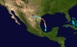
Hurricane Bret was the first of five Category 4 hurricanes that developed during the 1999 Atlantic hurricane season
and the first tropical cyclone
since Hurricane Jerry in 1989
to make landfall in Texas at hurricane intensity. Forming from a tropical wave
on August 18, Bret slowly organized within weak steering currents in the Bay of Campeche
. By August 20, the storm began to track northward and underwent rapid intensification
on August 21. After this period of strengthening, Bret attained its peak intensity with winds of 145 mph (230 km/h) and a barometric pressure of 944 mbar (hPa; 27.88 inHg). Later that day, the storm weakened to a Category 3 hurricane and made landfall
on Padre Island
, Texas. Shortly thereafter, the storm weakened further, becoming a tropical depression 24 hours after moving inland. The remnants of the storm eventually dissipated early on August 26 over northern Mexico.
Along the Texas coastline, Bret threatened several cities, prompting 180,000 residents to evacuate. Numerous shelters were opened throughout the region and prisons were evacuated. Several days prior to the storm's arrival, the NHC issued hurricane watches
, and later warnings for areas near the Texas–Mexico border. Several major roads leading to barrier island towns were shut down to prevent residents from crossing bridges during the hurricane. In nearby Mexico, roughly 7,000 people left coastal areas in advance of the storm. Officials also set up hundreds of shelters in northern regions of the country in case of major flooding.
Bret made landfall in a sparsely populated region, resulting in relatively little damage in comparison to its intensity. Nevertheless, seven people were killed in relation to storm, four in Texas and three in Mexico. Most of the deaths were due to car accidents caused by slippery roads. Upon making landfall, the hurricane produced a maximum storm surge
of 8.8 ft (2.7 m) at Matagorda Island
, Texas. Heavy rains produced by Bret peaked at 13.18 in (334.8 mm) in Texas and were estimated over 14 in (355.6 mm) in Mexico. Numerous homes in the affected regions were damaged or destroyed, leaving roughly 150 people homeless. In all, the storm caused $15 million (1999 USD; $19.7 million 2009 USD) in damage.
 Hurricane Bret originated from a tropical wave
that moved off the west coast of Africa on August 5. The wave tracked generally westward, interacting with an upper-level low on August 15 in the western Caribbean Sea
, and spawned a low pressure area
. Convective activity
developed around the low, and by August 18 the system was over the Yucatán Peninsula
. Later that day, the disturbance emerged into the Bay of Campeche
and a Hurricane Hunter reconnaissance mission into the system revealed that it had matured into a tropical depression around 1:00 pm CDT (1800 UTC
), the third of the 1999 season
. Initially, moderate wind shear
prevented the depression from strengthening as it moved slowly and erratically in response to weak steering currents over the system. By August 19, the wind shear relented, allowing deep convection
to develop over the center; later that day, the National Hurricane Center
(NHC) upgraded the system to a tropical storm, assigning it the name Bret. A small tropical cyclone, Bret gradually strengthened for several days as it tracked towards the north. By the morning of August 20, rainband
s began to form.
By the evening of August 20, Bret was designated a hurricane following reports of 75 mph (120 km/h) winds during a Hurricane Hunter mission. At around the same time, Bret established a north-northwest track under the influences of a mid-level ridge
. The following day, Bret began to undergo rapid intensification
, as a well-defined eye
developed. On the morning of August 22, the storm attained its peak intensity as a Category 4 hurricane with winds of 145 mph (230 km/h) and a barometric pressure of 944 mbar (hPa; 27.88 inHg). Shortly thereafter, an upper-level trough
to the west of the storm began to erode its cloud pattern.
Late on August 22, Bret turned northwestward in response to a mid-tropospheric ridge over the Gulf of Mexico and a mid-tropospheric circulation over the Rio Grande Valley
. Several hours before landfall, the hurricane weakened to Category 3 intensity and its forward motion slowed. At around 7:00 pm CDT (0000 UTC; August 23), Hurricane Bret passed over Padre Island, Texas, with winds of 115 mph (185 km/h) and a barometric pressure of 951 mbar (hPa; 28.08 inHg), which marked its landfall. The hurricane rapidly weakened upon moving inland, and roughly 12 hours after landfall, Bret weakened to a tropical storm. It further degenerated into a tropical depression by the evening of August 23. The remnants of Bret persisted until August 26, at which time they dissipated over the mountains of northern Mexico.
 On August 21, when Bret was first expected to approach the Texas coastline, the NHC issued a hurricane watch for coastal areas between the border of Mexico and Baffin Bay, Texas
. Hours later, the watch was upgraded to a warning as the storm intensified and posed a more direct threat to the area. A tropical storm warning and hurricane watch were subsequently posted from Baffin Bay northward to Port Aransas
. The following day, the hurricane warning was extended to include locations through Port O'Connor
and the advisories were extended to Freeport
. As Bret neared landfall, the hurricane watch between Port O'Connor and Freeport was discontinued. The hurricane warning for Port Aransas to Port O'Connor was discontinued hours after Bret made landfall and began to weaken. By late August 23, all watches and warnings in relation to the hurricane were discontinued.
By August 22, city officials in Corpus Christi, Texas
declared a state of emergency as Bret was considered a significant threat to the region. Tens of thousands of residents were urged to evacuate coastal areas and seek refuge in local shelters or with relatives further inland. An estimated 180,000 people in the state left their residences ahead of the storm. The Corpus Christi International Airport
closed midday on August 22. Later that day, Texas State Highway 361
and docks in Port Aransas
were shut down. Highways throughout the area were congested due to the large-scale evacuations and long lines for gas and emergency items developed. Three schools, two universities and a college were closed on August 23 and remained closed for several days.
Eleven shelters were opened in the San Antonio
area, collectively able to accommodate 3,525 people. About 325 prisoners were evacuated from a Nueces County jail as the building they were in was deemed unsafe during hurricane conditions. About 1,000 sailors working in the area were evacuated to the USS Inchon prior to the storm. Originally, the ship was meant to ride out the storm at sea; however, inadequate repair work inhibited the ship from leaving port. The ship reportedly had enough supplies to maintain the sailors for roughly 45 days. By 12:00 pm CDT on August 22, Mustang Island
and Padre Island
were completely evacuated and officials shut down roads leading in and out of the islands to prevent anyone from re-entering them before the area was deemed safe to enter. A strict order against price gouging
was put in place by city officials in Corpus Christi.
was declared for Tamaulipas
. The following day, at least 120 firefighters were dispatched to Monterrey, Nuevo Leon to swiftly respond to emergencies. The Mexican government emphasized the safety of residents in the city, which was anticipated to bear the brunt of the hurricane. Around 7,000 fishermen evacuated coastal regions near the Texas border. In Matamoros
an additional 31 shelters were opened. Schools throughout northern Mexico were closed for several days.
 Prior to developing into a tropical depression, the disturbance produced scattered rainfall across the Yucatán Peninsula
, locally exceeding 7 in (177.8 mm). As the system stalled in the Bay of Campeche
, coastal areas received minor rainfall from the outer bands
of the system. Although Bret made landfall near the Texas-Mexico border, the small size of the system resulted in limited impacts in Mexico. In Nuevo Leon
, an estimated 14 in (355.6 mm) of rain fell within a 24-hour span and similar amounts likely fell in nearby Tamaulipas
. In Tamaulipas, Nuevo Leon and Coahuila
, ten villages were isolated by floodwaters that washed out roads. Ten people, all members of one family, were injured during a head-on collision. In Nogales, heavy rains caused water to accumulate on streets, leading to traffic jams; high winds also downed power lines. During the evacuation prior to Bret, one person was trampled to death. Following landfall, a man was electrocuted by downed power lines and another drowned in floodwaters. At least 150 families were left homeless following a flash flood in Cadereyta that inundated most of the town.
 Upon making landfall, Bret produced a storm surge
up to 8.8 ft (2.7 m) on Matagorda Island, Texas. Around Galveston
, minor beach erosion was recorded due to large swells produced by the hurricane. Twelve new inlets were created on Padre Island
, one of which was large enough to be mistaken as Mansfield Pass. Heavy precipitation, reaching 13.18 in (334.8 mm) in central Kenedy County, was confined to a small area. The lowest barometric pressure recorded overland was at the Brooks County Airport at 976 mbar (hPa; 28.84 inHg). The Aransas River
rapidly reached flood stage due to heavy rains and the Rio Grande
produced minor flooding close to the Gulf of Mexico
. In beaches near Corpus Christi, upwards of 40 ft3 (1.1 m3) of sand was lost. About 24.7 acres (10 ha) of cropland were destroyed by the storm.
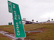
A damaged electric tower in Kenedy County resulted in power outages for thousands of people. At the height of the storm, an estimated 64,000 people were without power in south Texas. Portions of Texas State Highway Loop 281
were submerged in floodwaters, leaving $50,000 (1999 USD) in damage. Damage in Corpus Christi were estimated at $100,000 (1999 USD). In Duval County, 200 homes were damaged by flooding and large areas of agricultural land were flooded. Damage in the county amounted to roughly $2 million (1999 USD). Five other F0
tornado
es touched down in the state. Damage to homes and businesses in Corpus Christi was estimated up to $500,000 (1999 USD); agricultural damage reached $1 million and another $500,000 (1999 USD) was reported in losses. Slick roads from Bret's heavy rains caused the collision of a truck and a tractor, killing four people. Damage amounted to $15 million (1999 USD) throughout southern Texas.
 On August 23, the Federal Emergency Management Agency
(FEMA) deployed 717 personnel, mainly from the disaster response team, to the affected regions in the United States. The following day, 564 National Guard troops were deployed in the state. In the days following the storm, many mosquitoes and other insects laid eggs in areas of standing water, causing a large increase in their numbers. Authorities sprayed insecticide to minimize the potential for disease outbreaks. By August 25, all shelters opened prior to Bret were closed as residents were allowed to return home. On August 26, President Bill Clinton
added the counties of Brooks, Duval, Jim Wells and Webb to the major disaster declaration area. This allowed residents in those counties to receive federal funding.
Reconstruction of public facilities, roads, and water pipes received increased funding on September 3 to speed up the program. The following day, twelve disaster recovery centers were opened in the affected counties for residents to apply for federal funding. On September 9, two more disaster recovery centers were opened for residents in south Texas. Later that day, $831,593.28 (1999 USD) in disaster housing grants was distributed to affected residents. On September 15, roughly 10,200 people applied for disaster loans, amounting to $3.1 million (1999 USD). A total of 167 also received crisis intervention from FEMA. In Corpus Christi, winds and rain covered the city in debris and brush, costing $200,000 (1999 USD) for clean-up.
1999 Atlantic hurricane season
The 1999 Atlantic hurricane season officially began on June 1, 1999, and lasted until November 30, 1999. These dates conventionally delimit the period of each year when most tropical cyclones form in the Atlantic basin....
and the first tropical cyclone
Tropical cyclone
A tropical cyclone is a storm system characterized by a large low-pressure center and numerous thunderstorms that produce strong winds and heavy rain. Tropical cyclones strengthen when water evaporated from the ocean is released as the saturated air rises, resulting in condensation of water vapor...
since Hurricane Jerry in 1989
Hurricane Jerry (1989)
Hurricane Jerry was the tenth named storm and the sixth and final hurricane of the 1989 Atlantic hurricane season. Jerry was also the fourth U.S. landfalling storm and the third storm to strike Texas during the 1989 season; the two previous storms were Allison in June and Chantal in August. When it...
to make landfall in Texas at hurricane intensity. Forming from a tropical wave
Tropical wave
Tropical waves, easterly waves, or tropical easterly waves, also known as African easterly waves in the Atlantic region, are a type of atmospheric trough, an elongated area of relatively low air pressure, oriented north to south, which move from east to west across the tropics causing areas of...
on August 18, Bret slowly organized within weak steering currents in the Bay of Campeche
Bay of Campeche
The Bay of Campeche is the southern bight of the Gulf of Mexico. It is surrounded on three sides by the Mexican states of Campeche, Tabasco and Veracruz. It was named by Francisco Hernández de Córdoba and Antonio de Alaminos during their expedition in 1517...
. By August 20, the storm began to track northward and underwent rapid intensification
Rapid deepening
Rapid deepening, also known as rapid intensification, is a meteorological condition that occurs when the minimum sea-level atmospheric pressure of a tropical cyclone decreases drastically in a short period of time. The National Weather Service describes rapid deepening as a decrease of...
on August 21. After this period of strengthening, Bret attained its peak intensity with winds of 145 mph (230 km/h) and a barometric pressure of 944 mbar (hPa; 27.88 inHg). Later that day, the storm weakened to a Category 3 hurricane and made landfall
Landfall (meteorology)
Landfall is the event of a tropical cyclone or a waterspout coming onto land after being over water. When a waterspout makes landfall it is reclassified as a tornado, which can then cause damage inland...
on Padre Island
Padre Island
Padre Island is part of the U.S. state of Texas. The island is located on Texas' southern coast of the Gulf of Mexico and is famous for its white sandy beaches at the south end...
, Texas. Shortly thereafter, the storm weakened further, becoming a tropical depression 24 hours after moving inland. The remnants of the storm eventually dissipated early on August 26 over northern Mexico.
Along the Texas coastline, Bret threatened several cities, prompting 180,000 residents to evacuate. Numerous shelters were opened throughout the region and prisons were evacuated. Several days prior to the storm's arrival, the NHC issued hurricane watches
Tropical cyclone warnings and watches
Warnings and watches are two levels of alert issued by national weather forecasting bodies to coastal areas threatened by the imminent approach of a tropical cyclone of tropical storm or hurricane intensity. They are notices to the local population and civil authorities to make appropriate...
, and later warnings for areas near the Texas–Mexico border. Several major roads leading to barrier island towns were shut down to prevent residents from crossing bridges during the hurricane. In nearby Mexico, roughly 7,000 people left coastal areas in advance of the storm. Officials also set up hundreds of shelters in northern regions of the country in case of major flooding.
Bret made landfall in a sparsely populated region, resulting in relatively little damage in comparison to its intensity. Nevertheless, seven people were killed in relation to storm, four in Texas and three in Mexico. Most of the deaths were due to car accidents caused by slippery roads. Upon making landfall, the hurricane produced a maximum storm surge
Storm surge
A storm surge is an offshore rise of water associated with a low pressure weather system, typically tropical cyclones and strong extratropical cyclones. Storm surges are caused primarily by high winds pushing on the ocean's surface. The wind causes the water to pile up higher than the ordinary sea...
of 8.8 ft (2.7 m) at Matagorda Island
Matagorda Island
Matagorda Island, Spanish for "thick brush," is a 38 mile long barrier island on the Texas Gulf coast, about seven miles south of Port O'Connor, in the southernmost part of Calhoun County. The island is oriented generally northeast-southwest, with the Gulf of Mexico on the east and south, and...
, Texas. Heavy rains produced by Bret peaked at 13.18 in (334.8 mm) in Texas and were estimated over 14 in (355.6 mm) in Mexico. Numerous homes in the affected regions were damaged or destroyed, leaving roughly 150 people homeless. In all, the storm caused $15 million (1999 USD; $19.7 million 2009 USD) in damage.
Meteorological history
Tropical wave
Tropical waves, easterly waves, or tropical easterly waves, also known as African easterly waves in the Atlantic region, are a type of atmospheric trough, an elongated area of relatively low air pressure, oriented north to south, which move from east to west across the tropics causing areas of...
that moved off the west coast of Africa on August 5. The wave tracked generally westward, interacting with an upper-level low on August 15 in the western Caribbean Sea
Caribbean Sea
The Caribbean Sea is a sea of the Atlantic Ocean located in the tropics of the Western hemisphere. It is bounded by Mexico and Central America to the west and southwest, to the north by the Greater Antilles, and to the east by the Lesser Antilles....
, and spawned a low pressure area
Low pressure area
A low-pressure area, or "low", is a region where the atmospheric pressure at sea level is below that of surrounding locations. Low-pressure systems form under areas of wind divergence which occur in upper levels of the troposphere. The formation process of a low-pressure area is known as...
. Convective activity
Atmospheric convection
Atmospheric convection is the result of a parcel-environment instability, or temperature difference, layer in the atmosphere. Different lapse rates within dry and moist air lead to instability. Mixing of air during the day which expands the height of the planetary boundary layer leads to...
developed around the low, and by August 18 the system was over the Yucatán Peninsula
Yucatán Peninsula
The Yucatán Peninsula, in southeastern Mexico, separates the Caribbean Sea from the Gulf of Mexico, with the northern coastline on the Yucatán Channel...
. Later that day, the disturbance emerged into the Bay of Campeche
Bay of Campeche
The Bay of Campeche is the southern bight of the Gulf of Mexico. It is surrounded on three sides by the Mexican states of Campeche, Tabasco and Veracruz. It was named by Francisco Hernández de Córdoba and Antonio de Alaminos during their expedition in 1517...
and a Hurricane Hunter reconnaissance mission into the system revealed that it had matured into a tropical depression around 1:00 pm CDT (1800 UTC
Coordinated Universal Time
Coordinated Universal Time is the primary time standard by which the world regulates clocks and time. It is one of several closely related successors to Greenwich Mean Time. Computer servers, online services and other entities that rely on having a universally accepted time use UTC for that purpose...
), the third of the 1999 season
1999 Atlantic hurricane season
The 1999 Atlantic hurricane season officially began on June 1, 1999, and lasted until November 30, 1999. These dates conventionally delimit the period of each year when most tropical cyclones form in the Atlantic basin....
. Initially, moderate wind shear
Wind shear
Wind shear, sometimes referred to as windshear or wind gradient, is a difference in wind speed and direction over a relatively short distance in the atmosphere...
prevented the depression from strengthening as it moved slowly and erratically in response to weak steering currents over the system. By August 19, the wind shear relented, allowing deep convection
Atmospheric convection
Atmospheric convection is the result of a parcel-environment instability, or temperature difference, layer in the atmosphere. Different lapse rates within dry and moist air lead to instability. Mixing of air during the day which expands the height of the planetary boundary layer leads to...
to develop over the center; later that day, the National Hurricane Center
National Hurricane Center
The National Hurricane Center , located at Florida International University in Miami, Florida, is the division of the National Weather Service responsible for tracking and predicting weather systems within the tropics between the Prime Meridian and the 140th meridian west poleward to the 30th...
(NHC) upgraded the system to a tropical storm, assigning it the name Bret. A small tropical cyclone, Bret gradually strengthened for several days as it tracked towards the north. By the morning of August 20, rainband
Rainband
A rainband is a cloud and precipitation structure associated with an area of rainfall which is significantly elongated. Rainbands can be stratiform or convective, and are generated by differences in temperature. When noted on weather radar imagery, this precipitation elongation is referred to as...
s began to form.
By the evening of August 20, Bret was designated a hurricane following reports of 75 mph (120 km/h) winds during a Hurricane Hunter mission. At around the same time, Bret established a north-northwest track under the influences of a mid-level ridge
Ridge (meteorology)
A ridge is an elongated region of relatively high atmospheric pressure, the opposite of a trough....
. The following day, Bret began to undergo rapid intensification
Rapid deepening
Rapid deepening, also known as rapid intensification, is a meteorological condition that occurs when the minimum sea-level atmospheric pressure of a tropical cyclone decreases drastically in a short period of time. The National Weather Service describes rapid deepening as a decrease of...
, as a well-defined eye
Eye (cyclone)
The eye is a region of mostly calm weather found at the center of strong tropical cyclones. The eye of a storm is a roughly circular area and typically 30–65 km in diameter. It is surrounded by the eyewall, a ring of towering thunderstorms where the second most severe weather of a cyclone...
developed. On the morning of August 22, the storm attained its peak intensity as a Category 4 hurricane with winds of 145 mph (230 km/h) and a barometric pressure of 944 mbar (hPa; 27.88 inHg). Shortly thereafter, an upper-level trough
Trough (meteorology)
A trough is an elongated region of relatively low atmospheric pressure, often associated with fronts.Unlike fronts, there is not a universal symbol for a trough on a weather chart. The weather charts in some countries or regions mark troughs by a line. In the United States, a trough may be marked...
to the west of the storm began to erode its cloud pattern.
Late on August 22, Bret turned northwestward in response to a mid-tropospheric ridge over the Gulf of Mexico and a mid-tropospheric circulation over the Rio Grande Valley
Rio Grande Valley
The Rio Grande Valley or the Lower Rio Grande Valley, informally called The Valley, is an area located in the southernmost tip of South Texas...
. Several hours before landfall, the hurricane weakened to Category 3 intensity and its forward motion slowed. At around 7:00 pm CDT (0000 UTC; August 23), Hurricane Bret passed over Padre Island, Texas, with winds of 115 mph (185 km/h) and a barometric pressure of 951 mbar (hPa; 28.08 inHg), which marked its landfall. The hurricane rapidly weakened upon moving inland, and roughly 12 hours after landfall, Bret weakened to a tropical storm. It further degenerated into a tropical depression by the evening of August 23. The remnants of Bret persisted until August 26, at which time they dissipated over the mountains of northern Mexico.
Texas
Baffin Bay, Texas
Baffin Bay is a bay in South Texas, an inlet of the larger Laguna Madre. Located near the Gulf of Mexico, Baffin Bay forms part of the boundary between Kenedy County and Kleberg County.-Etymology:The history of the bay name is unclear...
. Hours later, the watch was upgraded to a warning as the storm intensified and posed a more direct threat to the area. A tropical storm warning and hurricane watch were subsequently posted from Baffin Bay northward to Port Aransas
Port Aransas, Texas
Port Aransas is a city in Nueces County, Texas. The population was 3,370 at the 2000 census.-Early history:Karankawa Indians played a key role in the early development of the Texas Gulf Coast. The Karankawa Indians inhabited the Gulf Coast of Texas from Galveston Bay all the way to Corpus Christi Bay...
. The following day, the hurricane warning was extended to include locations through Port O'Connor
Port O'Connor, Texas
Port O'Connor is an unincorporated village in Calhoun County, Texas, United States, on the coastline between Galveston and Corpus Christi. The ZIP Code Tabulation Area including Port O'Connor had a population of 1,078 at the 2000 census...
and the advisories were extended to Freeport
Freeport, Texas
Freeport is a city in Brazoria County, Texas within the Houston–Sugar Land–Baytown metropolitan area and is situated in Southeast Texas. As of the 2000 U.S...
. As Bret neared landfall, the hurricane watch between Port O'Connor and Freeport was discontinued. The hurricane warning for Port Aransas to Port O'Connor was discontinued hours after Bret made landfall and began to weaken. By late August 23, all watches and warnings in relation to the hurricane were discontinued.
By August 22, city officials in Corpus Christi, Texas
Corpus Christi, Texas
Corpus Christi is a coastal city in the South Texas region of the U.S. state of Texas. The county seat of Nueces County, it also extends into Aransas, Kleberg, and San Patricio counties. The MSA population in 2008 was 416,376. The population was 305,215 at the 2010 census making it the...
declared a state of emergency as Bret was considered a significant threat to the region. Tens of thousands of residents were urged to evacuate coastal areas and seek refuge in local shelters or with relatives further inland. An estimated 180,000 people in the state left their residences ahead of the storm. The Corpus Christi International Airport
Corpus Christi International Airport
Corpus Christi International Airport is a city-owned public-use airport located five nautical miles west of the central business district of Corpus Christi, in Nueces County, Texas, United States.The airport's new six gate, . Hayden W...
closed midday on August 22. Later that day, Texas State Highway 361
Texas State Highway 361
State Highway 361 or SH 361 is a state highway that runs from Gregory in southern Texas, near Corpus Christi, east and south to Padre Island on the Gulf of Mexico coast.-History:...
and docks in Port Aransas
Port Aransas, Texas
Port Aransas is a city in Nueces County, Texas. The population was 3,370 at the 2000 census.-Early history:Karankawa Indians played a key role in the early development of the Texas Gulf Coast. The Karankawa Indians inhabited the Gulf Coast of Texas from Galveston Bay all the way to Corpus Christi Bay...
were shut down. Highways throughout the area were congested due to the large-scale evacuations and long lines for gas and emergency items developed. Three schools, two universities and a college were closed on August 23 and remained closed for several days.
Eleven shelters were opened in the San Antonio
San Antonio, Texas
San Antonio is the seventh-largest city in the United States of America and the second-largest city within the state of Texas, with a population of 1.33 million. Located in the American Southwest and the south–central part of Texas, the city serves as the seat of Bexar County. In 2011,...
area, collectively able to accommodate 3,525 people. About 325 prisoners were evacuated from a Nueces County jail as the building they were in was deemed unsafe during hurricane conditions. About 1,000 sailors working in the area were evacuated to the USS Inchon prior to the storm. Originally, the ship was meant to ride out the storm at sea; however, inadequate repair work inhibited the ship from leaving port. The ship reportedly had enough supplies to maintain the sailors for roughly 45 days. By 12:00 pm CDT on August 22, Mustang Island
Mustang Island
Mustang Island is a barrier island on the Gulf Coast of Texas in the United States. The island is 18 miles long, stretching from Corpus Christi to Port Aransas. The island is oriented generally northeast-southwest, with the Gulf of Mexico on the east and south, and Corpus Christi Bay on the north...
and Padre Island
Padre Island
Padre Island is part of the U.S. state of Texas. The island is located on Texas' southern coast of the Gulf of Mexico and is famous for its white sandy beaches at the south end...
were completely evacuated and officials shut down roads leading in and out of the islands to prevent anyone from re-entering them before the area was deemed safe to enter. A strict order against price gouging
Price gouging
Price gouging is a pejorative term referring to a situation in which a seller prices goods or commodities much higher than is considered reasonable or fair. In precise, legal usage, it is the name of a crime that applies in some of the United States during civil emergencies...
was put in place by city officials in Corpus Christi.
Mexico
In Mexico, officials closed 18 ports on the Gulf of Mexico to small- and medium-sized craft in preparation for the storm. In northern Mexico, more than 500 shelters were opened as thousands of residents were advised to evacuate from low-lying areas. The Mexican Army, Red Cross, and firefighters were put on standby to deal with emergency calls during the storm. On August 22, a state of emergencyState of emergency
A state of emergency is a governmental declaration that may suspend some normal functions of the executive, legislative and judicial powers, alert citizens to change their normal behaviours, or order government agencies to implement emergency preparedness plans. It can also be used as a rationale...
was declared for Tamaulipas
Tamaulipas
Tamaulipas officially Estado Libre y Soberano de Tamaulipas is one of the 31 states which, with the Federal District, comprise the 32 Federal Entities of Mexico. It is divided in 43 municipalities and its capital city is Ciudad Victoria. The capital city was named after Guadalupe Victoria, the...
. The following day, at least 120 firefighters were dispatched to Monterrey, Nuevo Leon to swiftly respond to emergencies. The Mexican government emphasized the safety of residents in the city, which was anticipated to bear the brunt of the hurricane. Around 7,000 fishermen evacuated coastal regions near the Texas border. In Matamoros
Matamoros, Tamaulipas
Matamoros, officially known as Heroica Matamoros, is a city in the northeastern part of Tamaulipas, in the country of Mexico. It is located on the southern bank of the Rio Grande, directly across the border from Brownsville, Texas, in the United States. Matamoros is the second largest and second...
an additional 31 shelters were opened. Schools throughout northern Mexico were closed for several days.
Mexico
Yucatán Peninsula
The Yucatán Peninsula, in southeastern Mexico, separates the Caribbean Sea from the Gulf of Mexico, with the northern coastline on the Yucatán Channel...
, locally exceeding 7 in (177.8 mm). As the system stalled in the Bay of Campeche
Bay of Campeche
The Bay of Campeche is the southern bight of the Gulf of Mexico. It is surrounded on three sides by the Mexican states of Campeche, Tabasco and Veracruz. It was named by Francisco Hernández de Córdoba and Antonio de Alaminos during their expedition in 1517...
, coastal areas received minor rainfall from the outer bands
Rainband
A rainband is a cloud and precipitation structure associated with an area of rainfall which is significantly elongated. Rainbands can be stratiform or convective, and are generated by differences in temperature. When noted on weather radar imagery, this precipitation elongation is referred to as...
of the system. Although Bret made landfall near the Texas-Mexico border, the small size of the system resulted in limited impacts in Mexico. In Nuevo Leon
Nuevo León
Nuevo León It is located in Northeastern Mexico. It is bordered by the states of Tamaulipas to the north and east, San Luis Potosí to the south, and Coahuila to the west. To the north, Nuevo León has a 15 kilometer stretch of the U.S.-Mexico border adjacent to the U.S...
, an estimated 14 in (355.6 mm) of rain fell within a 24-hour span and similar amounts likely fell in nearby Tamaulipas
Tamaulipas
Tamaulipas officially Estado Libre y Soberano de Tamaulipas is one of the 31 states which, with the Federal District, comprise the 32 Federal Entities of Mexico. It is divided in 43 municipalities and its capital city is Ciudad Victoria. The capital city was named after Guadalupe Victoria, the...
. In Tamaulipas, Nuevo Leon and Coahuila
Coahuila
Coahuila, formally Coahuila de Zaragoza , officially Estado Libre y Soberano de Coahuila de Zaragoza is one of the 31 states which, with the Federal District, comprise the 32 Federal Entities of Mexico...
, ten villages were isolated by floodwaters that washed out roads. Ten people, all members of one family, were injured during a head-on collision. In Nogales, heavy rains caused water to accumulate on streets, leading to traffic jams; high winds also downed power lines. During the evacuation prior to Bret, one person was trampled to death. Following landfall, a man was electrocuted by downed power lines and another drowned in floodwaters. At least 150 families were left homeless following a flash flood in Cadereyta that inundated most of the town.
Texas
Storm surge
A storm surge is an offshore rise of water associated with a low pressure weather system, typically tropical cyclones and strong extratropical cyclones. Storm surges are caused primarily by high winds pushing on the ocean's surface. The wind causes the water to pile up higher than the ordinary sea...
up to 8.8 ft (2.7 m) on Matagorda Island, Texas. Around Galveston
Galveston, Texas
Galveston is a coastal city located on Galveston Island in the U.S. state of Texas. , the city had a total population of 47,743 within an area of...
, minor beach erosion was recorded due to large swells produced by the hurricane. Twelve new inlets were created on Padre Island
Padre Island
Padre Island is part of the U.S. state of Texas. The island is located on Texas' southern coast of the Gulf of Mexico and is famous for its white sandy beaches at the south end...
, one of which was large enough to be mistaken as Mansfield Pass. Heavy precipitation, reaching 13.18 in (334.8 mm) in central Kenedy County, was confined to a small area. The lowest barometric pressure recorded overland was at the Brooks County Airport at 976 mbar (hPa; 28.84 inHg). The Aransas River
Aransas River
The Aransas River is a short river in south Texas in the United States. It drains an area of the south Texas coastal plains into the Gulf of Mexico. It rises in Bee County southwest of Beeville and north of Skidmore, from the confluence of three creeks: Olmos, Aransas, and Poesta...
rapidly reached flood stage due to heavy rains and the Rio Grande
Rio Grande
The Rio Grande is a river that flows from southwestern Colorado in the United States to the Gulf of Mexico. Along the way it forms part of the Mexico – United States border. Its length varies as its course changes...
produced minor flooding close to the Gulf of Mexico
Gulf of Mexico
The Gulf of Mexico is a partially landlocked ocean basin largely surrounded by the North American continent and the island of Cuba. It is bounded on the northeast, north and northwest by the Gulf Coast of the United States, on the southwest and south by Mexico, and on the southeast by Cuba. In...
. In beaches near Corpus Christi, upwards of 40 ft3 (1.1 m3) of sand was lost. About 24.7 acres (10 ha) of cropland were destroyed by the storm.
A damaged electric tower in Kenedy County resulted in power outages for thousands of people. At the height of the storm, an estimated 64,000 people were without power in south Texas. Portions of Texas State Highway Loop 281
Texas State Highway Loop 281
State Highway Loop 281 or Loop 281 is a Texas state highway loop around the city of Longview. It runs from I-20 / US 259 / SH 322 in a clockwise direction back to I-20 near Longview. It is also known as Tomlinson Parkway in northern Longview.-History:...
were submerged in floodwaters, leaving $50,000 (1999 USD) in damage. Damage in Corpus Christi were estimated at $100,000 (1999 USD). In Duval County, 200 homes were damaged by flooding and large areas of agricultural land were flooded. Damage in the county amounted to roughly $2 million (1999 USD). Five other F0
Fujita scale
The Fujita scale , or Fujita-Pearson scale, is a scale for rating tornado intensity, based primarily on the damage tornadoes inflict on human-built structures and vegetation...
tornado
Tornado
A tornado is a violent, dangerous, rotating column of air that is in contact with both the surface of the earth and a cumulonimbus cloud or, in rare cases, the base of a cumulus cloud. They are often referred to as a twister or a cyclone, although the word cyclone is used in meteorology in a wider...
es touched down in the state. Damage to homes and businesses in Corpus Christi was estimated up to $500,000 (1999 USD); agricultural damage reached $1 million and another $500,000 (1999 USD) was reported in losses. Slick roads from Bret's heavy rains caused the collision of a truck and a tractor, killing four people. Damage amounted to $15 million (1999 USD) throughout southern Texas.
Aftermath
Federal Emergency Management Agency
The Federal Emergency Management Agency is an agency of the United States Department of Homeland Security, initially created by Presidential Reorganization Plan No. 1 of 1978 and implemented by two Executive Orders...
(FEMA) deployed 717 personnel, mainly from the disaster response team, to the affected regions in the United States. The following day, 564 National Guard troops were deployed in the state. In the days following the storm, many mosquitoes and other insects laid eggs in areas of standing water, causing a large increase in their numbers. Authorities sprayed insecticide to minimize the potential for disease outbreaks. By August 25, all shelters opened prior to Bret were closed as residents were allowed to return home. On August 26, President Bill Clinton
Bill Clinton
William Jefferson "Bill" Clinton is an American politician who served as the 42nd President of the United States from 1993 to 2001. Inaugurated at age 46, he was the third-youngest president. He took office at the end of the Cold War, and was the first president of the baby boomer generation...
added the counties of Brooks, Duval, Jim Wells and Webb to the major disaster declaration area. This allowed residents in those counties to receive federal funding.
Reconstruction of public facilities, roads, and water pipes received increased funding on September 3 to speed up the program. The following day, twelve disaster recovery centers were opened in the affected counties for residents to apply for federal funding. On September 9, two more disaster recovery centers were opened for residents in south Texas. Later that day, $831,593.28 (1999 USD) in disaster housing grants was distributed to affected residents. On September 15, roughly 10,200 people applied for disaster loans, amounting to $3.1 million (1999 USD). A total of 167 also received crisis intervention from FEMA. In Corpus Christi, winds and rain covered the city in debris and brush, costing $200,000 (1999 USD) for clean-up.
See also
- Other storms of the same name
- List of Texas hurricanes
- List of Category 4 Atlantic hurricanes