
Interstate 45
Encyclopedia
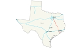
Interstate 45 is an intrastate Interstate Highway located entirely within the U.S. state
of Texas
. It connects the cities of Dallas and Houston, continuing southeast from Houston to Galveston
over the Galveston Causeway
to the Gulf of Mexico
. Interstate 45 is the only intrastate Interstate Highway ending in 5 or 0.
I-45 replaced US 75 over its entire length, although portions of US 75 remained parallel to I-45 until its elimination south of downtown Dallas in 1987. At the south end of I-45, State Highway 87
(formerly part of US 75) continues into downtown Galveston. The north end is at Interstate 30 in downtown Dallas
, where US 75 used the Good-Latimer Expressway
. A short continuation, known by traffic reporters as the I-45 overhead, signed as part of US 75, and officially Interstate 345, continues north to the merge with the current end of US 75. Traffic can use Spur 366 to connect to Interstate 35E
at the north end of I-345.
The portion of I-45 between downtown Houston and Galveston is known to Houston residents as the Gulf Freeway. The short elevated section of I-45 near downtown Houston is known as the Pierce Elevated, after the surface street next to which the freeway runs, while north of Interstate 10 it is known as the North Freeway. I-45 and I-345 in the Dallas area, north of the interchanges with Interstate 20 and State Highway 310
(old US 75), is the Julius Schepps Freeway. The Gulf Freeway and North Freeway both include reversible
high-occupancy vehicle lane
s for bus
es and other high-occupancy vehicles to and from downtown Houston.
, Houston, and Dallas, I-45 serves a number of other communities, including La Marque
, League City
, Spring
, The Woodlands
, Conroe
, Willis
, Huntsville
, Madisonville
, Centerville
, Buffalo
, Fairfield
, Corsicana
, and Ennis
.
U.S. Highway 190 joins I-45 for 26 miles (41.8 km) from Huntsville, Texas
to Madisonville, Texas
. U.S. Highway 287 joins I-45 for 18 miles (29 km) from Corsicana, Texas
to Ennis, Texas
. US 287 signs are only posted (with I-45) from the northern end of Business Loop 45 in Corsicana to the Ellis County line.
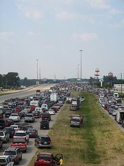 Interstate 45 gained notoriety during Hurricane Rita
in 2005. Thousands of Houston area evacuees jammed the roadway trying to leave. As a result, the freeway became a parking lot. Gas stations ran dry and hundreds of people's cars simply ran empty, their occupants having to spend the night along the shoulder. Four-hour drives suddenly became 24-hour drives. Even though the Texas Department of Transportation
started contraflow lane reversal
at FM 1488
, it did not alleviate the traffic jam deep into the city, as that starting point was even north of The Woodlands
, which is close to Conroe
, the northern terminus of the greater Houston area.
At just 284.913 miles (458.5 km), I-45 is the shortest of the primary interstates (those ending in 0 or 5).
--opened in stages beginning on October 1, 1948, up to a full completion to Galveston in 1952, as part of U.S. Highway 75. At the north (Houston) end, it connects to the North Freeway via the short Pierce Elevated, completed in 1967. The section north of the curve near Monroe Road/State Highway 3
in southeastern Houston was built on the right-of-way
of the former Galveston-Houston Electric Railway
, which entered downtown on Pierce Street.
After several interchange
s, I-45 crosses the Galveston Causeway
and passes Tiki Island. The split with State Highway 6
and State Highway 146 (to State Highway 3
) may be the beginning of the Gulf Freeway; old U.S. Highway 75 south of this junction was upgraded on the spot.
The Gulf Freeway generally parallels State Highway 3
(old US 75) about 1 mile (1.5 km) to the west, bypassing La Marque, Dickinson and South Houston. It includes interchange
s with several other freeways: the Emmett F. Lowry Expressway (Farm to Market Road 1764
), NASA Road 1 Bypass and the Sam Houston Tollway, meeting the north end of State Highway 3 in southeastern Houston. (This part of SH 3 — on Winkler Drive and Monroe Road — is not part of old US 75.) A center reversible
HOV lane begins just south of the Sam Houston Tollway.
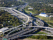 In Houston, I-45 meets Interstate Highway 610 and State Highway 35
at a complicated interchange
. At the merge with Spur 5, a short freeway spur to the University of Houston
, elevated collector/distributor roads (also part of Spur 5) begin. The C/D roads and the HOV lane end at Dowling Street, the original end of the Gulf Freeway. Just past Dowling Street is an interchange with U.S. Highway 59 (Eastex Freeway and Southwest Freeway) and State Highway 288
(South Freeway), after which I-45 technically becomes the North Freeway as it runs along the northwest half of the block between Pierce Street and Gray Street as the Pierce Elevated.
The reversible
high-occupancy vehicle lane
begins in downtown Houston at the intersection of St. Joseph Parkway and Dowling Street, with easy access inbound to St. Joseph Parkway and outbound from Pierce Street. It runs down the median of the Gulf Freeway, mostly at the same level as the main lanes. Ramps are provided for access to and from the following roads:
 The North Freeway HOV begins in downtown Houston near the University of Houston–Downtown
, with easy access inbound on Milam Street and outbound on Travis Street. Ramps and entrances are provided for access from the following roads:
The HOV ends approximately one mile north of the Cypress Creek Parkway (FM1960) exit.
Freeway in Dallas, from the Trinity River
to Downtown Dallas, is elevated above the surrounding areas for most of its length. As such, when ice storms hit the Dallas area (usually on average 1-2 times per year), the freeway is shut down, and traffic is diverted to State Highway 310
and U.S. Highway 175 which parallel I-45.
I-345 is just 1.4 miles (2.3 km) long and connects the end of I-45 to the end of US 75 along the east side of downtown Dallas. It is signed northbound as US 75 and southbound as I-45.
and Bryan
and continued on to Galveston. The more direct route followed by I-45 was not initially part of the system between Richland
and Huntsville
; this cutoff was added by 1919 as State Highway 32, and U.S. Highway 75 was assigned to the alignment in 1926. Prior to the coming of the Interstate Highway System
in the late 1950s, the only improvements to US 75 in Texas beyond building a two-lane paved roadway were in the Houston and Dallas areas. However, the highways in and near these cities included some of the first freeways in the state: the Gulf Freeway (Houston) and the Central Expressway
(Dallas).
began operating an interurban
between those cities on December 5, 1911, and last ran on October 31, 1936, though the Houston Electric Company, operator of Houston's city transit system, continued to run trains on the portion between downtown and Park Place
. A proposal for a "super-highway" between the cities was first made in 1930, and Houston Mayor Oscar Holcombe began to work towards it later that decade. He announced an agreement with the Houston Electric Company on April 12, 1940, through which the company could convert its four remaining lines to bus
es, in exchange for the right-of-way used by the Park Place line. This line was last used on June 9, 1940, the last day of streetcar service in Houston; the replacement is still operated by METRO as the 40 along Telephone Road.
Before the new highway was built, U.S. Highway 75 followed Galveston Road (now mostly State Highway 3
), Broadway Street, and Harrisburg Boulevard into downtown Houston. State Highway 225 carried traffic from La Porte
along La Porte Road to US 75 in Harrisburg, and State Highway 35
connected Alvin
with downtown Houston along Telephone Road and Leeland Street. Plans made in October 1943, when the Texas Transportation Commission signed an agreement with Houston and Harris County
, referred to the new bypass as a relocation of US 75. Drawings were released by the state on January 31, 1946, and included almost continuous frontage road
s, broken only at railroad crossings. Although the freeway ended at Live Oak Street, a so-called "four-street distribution system" of four one-way streets, timed for 30 miles per hour (50 km/h), carried traffic to Main Street. Initially, the two southwestern streets — Pierce Street and Calhoun Avenue (now St. Joseph Parkway) - carried traffic towards the freeway, and the other two — Jefferson and Pease Streets — carried exiting traffic; once the freeway was completed far enough to allow US 75 to be marked along it, Pease and Pierce Streets carried that highway to Fannin Street.
The first freeway dedication in the state took place at 7 p.m. on September 30, 1948, at the overpass over Calhoun Road by the University of Houston
. The roadway between downtown and Telephone Road was opened to traffic after speeches, but lacked an official name, being called the "Interurban Expressway", after the rail line that it replaced, by the press. Mayor Holcombe quickly started a contest to assign a name, and the city chose the winning entry on December 17, 1948. Sara Yancy of Houston Heights
won $100 for her submission of "Gulf Freeway", named for the Gulf of Mexico
that the highway would reach when completed. The freeway was extended to Griggs Road in February 1951, Reveille Street (onto which SH 35 was realigned) in July 1951, and was completed to the Galveston Causeway
on August 2, 1952, with a ceremony on the bridge over Farm to Market Road 517
near Dickinson
. However, beyond Reveille Street, the road was not built to freeway standards, with 32 at-grade intersection
s, though no traffic signals. The highway curved away from the old interurban right-of-way near Monroe Road, about where the Park Place streetcar line had ended. In December 1952, a short spur, now part of Interstate 610
, was opened to connect with SH 225. A three-way split in the northwest part of Park Place, near where Gulfgate Shopping Center
opened in 1956, carried non-stop traffic to and from SH 35 and SH 225. This split was also the location of a lane drop; the roadway carried six lanes (three in each direction) between Houston and the interchange, and four beyond to Galveston. After the new US 75 was completed, the old road between downtown and South Houston
was dropped from the state highway system, while the remainder became State Highway 3
, connecting to the Gulf Freeway via Winkler Drive, effective August 20, 1952.
The first major change was made in preparation for the North Freeway connection, when the directions of Calhoun Avenue and Jefferson Street were swapped so that they would alternate. A bridge, dated 1954, was built to carry traffic from Jefferson Street over traffic to Jefferson Street, and US 75 was moved to Calhoun Avenue northbound, soon crossing downtown on the one-way pair
of Calhoun Avenue and Pierce Street to the new North Freeway. A median barrier was added in 1956 to prevent crossover accidents. Southeast of downtown Houston, the at-grade intersections proved dangerous, and only two had been replaced with interchanges by 1959, when the Texas Highway Department began a program to upgrade the road to full freeway standards. Frontage road
s would be required along the entire highway, since the state had not purchased access rights
, and so abutting property owners were able to build driveways to the road. To accomplish this, traffic was shifted to the newly-built frontage roads so that the central main lanes could be reconstructed. This grade separation was completed from Houston to Almeda-Genoa Road (exit 34) in June 1959, Farm to Market Road 1959
(exit 30) in October 1964, Farm to Market Road 518
(exit 23) in December 1970, and Farm to Market Road 1764
(exit 15) in 1976. As the section beyond FM 1764 into Galveston had already been rebuilt, this marked the completion of the Gulf Freeway as an actual freeway.
 As the first freeway in Texas, the standards of the Gulf Freeway soon became inadequate, with poor sight lines and little room to merge when entering. It also attracted development, such as Gulfgate Shopping City, the first mall in the Houston area, the Manned Spacecraft Center, and many residential developments. Heavy congestion
began to affect the freeway by the early 1960s; two roughly parallel freeways — the Harrisburg Freeway and Alvin Freeway - were proposed at that time to relieve the traffic, but were not built. A short project to widen the road to six lanes between I-610 and Sims Bayou was completed in 1960, and ramp meter
s were installed in 1966. The I-610 interchange was rebuilt with direct connections for most movements in 1975. Plans to reconstruct the freeway near downtown began in 1972, taking about 170 houses and 22 businesses from the southwest side for the room to expand the main lanes and add parallel lanes for the Alvin Freeway. Local opposition was unsuccessful at stopping the project, and construction on this segment, and others to the southeast, took place in the 1980s. The lanes were shifted outward to make room for the transitway, which opened to I-610 on May 16, 1988. These lanes were inspired by the similar ones on the Shirley Highway in the Washington Metropolitan Area
. That year also marked the end of the reconstruction inside I-610, along with the elevated distribution lanes alongside the main lanes near downtown; the first short piece of the Alvin Freeway was finally connected to these in 1999. This project gave I-45 its current configuration, mostly eight main lanes wide, from Sims Bayou past I-610 to Griggs Road in 1981, to Telephone Road in 1982, to Lockwood Drive in 1985, and finally to downtown in 1988.
However, this was not the end of construction on the Gulf Freeway. The highway beyond I-610 to FM 1959, which had just been upgraded in the 1950s and 1960s, saw an extension of the transitway to a temporary end near FM 1959, widening to eight lanes, and a large stack interchange
at the Sam Houston Tollway. This reconstruction was completed between Almeda-Genoa Road and College Avenue in 1991, between College Avenue and Sims Bayou in 1994, and finally, in 1997, there was no construction anywhere on the entire length of the freeway when the tollway interchange was opened, along with the widening between Almeda-Genoa Road and FM 1959. A 1999 study recommended widening the entire stretch from the Sam Houston Tollway to Galveston to at least eight lanes. Construction to replace the Galveston Causeway
began in mid-2003, and work on a section through Webster
, including a new interchange with the NASA Road 1 Bypass, began in mid-2007.
Widening of the freeway between Kurland Drive and Clear Lake City Boulevard began in July 2011. This construction will expand the number of freeway lanes from six to ten, and increase the number of frontage lanes from four to six. It will also involve rebuilding the overpasses at Dixie Farm Road and Clear Lake City Boulevard. The project is expected to take four years to complete. According to the Texas Department of Transportation, the project is approximately five miles in length, starting at Kurland and ending approximately one mile south of Clear Lake City Boulevard.
The project has four phases. Phase one is the reconstruction of the main lanes from the northern end of the project to just south of FM 1959. The end of this phase will include the demolition and reconstruction of the bridge at the FM 1959 intersection. Phase two, planned to begin in the summer of 2012, will be the reconstruction of the frontage roads from just south of FM 1959 to the southern end of the project. Phase three will be the reconstruction of the main lanes on the southern half of the project, and is planned to begin in the summer of 2013. Phase four, scheduled to start in fall 2014, will be the demolition and reconstruction of the overpass at Clear Lake City Boulevard.
, connecting the two one-way pair
s from the north end of the Gulf Freeway with the south end of Houston Avenue. This was opened on December 12, 1955, and allowed US 75 to bypass its run on Main Street; it included interchanges with Allen Parkway
and Memorial Drive. The next piece near downtown opened on July 24, 1962, leaving the 1955 freeway in the Allen Parkway interchange, passing east of Houston Avenue, and connected to an already-built portion at I-610. The six-lane Pierce Elevated, which occupies half a block on the southwest side of Pierce Street, required the acquisition of a number of commercial properties; the cost prevented the full block from being used. This portion opened on August 18, 1967, connecting the Gulf and North Freeways and bypassing the "four-street distribution system", which remains in its original form to this day.
The first piece of the North Freeway to be built outside I-610 was an upgrade of existing US 75 on Stuebner Airline Road, between Airline Drive and Shepherd Drive, opened in December 1959. In April 1961, this was completed to the interchange with I-610, and on July 24, 1962 the downtown section was extended north to meet it. As each section opened, US 75 was moved to it, temporarily using I-610 to Airline Drive for about a year. At the other end, US 75 was upgraded from Spring Creek
at the north edge of Spring
north to the San Jacinto River south of Conroe
in 1960. In between, the upgrade was completed from Farm to Market Road 525
to near Richey Road in December 1961, south to the 1959 segment in February 1963, and north to the 1960 segment in March 1963, completing the North Freeway except for the Pierce Elevated (1967). The freeway as initially built had eight lanes (four in each direction) between downtown and I-610, six to Farm to Market Road 1960
, and four north of FM 1960.
Like the Gulf Freeway, the North Freeway soon became congested
. The oil boom
of the 1970s resulted in large-scale residential development along the highway, most notably The Woodlands
. Since the corridor was strongly directional, with 65% of peak-hour traffic going in the peak direction, a 9.6-mile (15.4 km) contraflow lane for bus
es and other high-occupancy vehicles (HOV) was implemented later that decade, opening on August 28, 1979 between downtown and Shepherd Drive (exit 56B). The facility, operating during both rush hour
periods, occupied the leftmost lane of the other direction, and was separated from the other lanes with a movable pylon
every 40 feet (12 m). In 1980, the existing center breakdown lanes were restriped for HOV traffic for about two miles (3 km) from the north end of the contraflow lane. However, off-peak traffic was increasing, and construction began in 1983 on a more permanent reversible transitway in the median. This, the second transitway in Houston (a month after the one on the Katy Freeway), opened on November 23, 1984, replacing the contraflow lane.
Reconstruction of the main lanes and frontage roads to handle increased traffic began in 1982 just north of downtown. No lanes were added south of I-610, but the eight-lane cross section, with room for a transitway, was continued north as construction progressed. Work was completed south of Airline Drive (exit 53) in about 1985, to Shepherd Drive (exit 56B) in 1987, and to Farm to Market Road 525
(exit 60A) in 1990; this last opening allowed the transitway to extend to just south of FM 525. The Hardy Toll Road
, completed on June 28, 1988 between I-610 and I-45 near The Woodlands, added capacity to that part of the corridor, and in 1990 reconstruction was completed on a short piece of I-45 from the toll road into The Woodlands. Reconstruction continued from FM 525, reaching Airtex Boulevard (exit 63) in 1997, including part of the Sam Houston Tollway interchange (completed in 2003) and a transitway extension, Cypresswood Drive (exit 68) in 1998, extending the transit way to its present terminus, and the Hardy Toll Road (exit 72) in 2003. Work on the section through The Woodlands to Research Forest Drive (exit 77) was completed in 2001, including a direct connection to Woodlands Parkway, and in 2003 work was completed to Farm to Market Road 1488
(exit 81). Construction is complete between FM 1488 and FM 3083 (Exit 90). Two more projects will extend eight lanes to Farm to Market Road 830 (exit 92), and another will take six lanes to the county line south of New Waverly
, near State Highway 75
(exit 98).
and Richland
was the bypass around Huntsville
.
The final piece of I-45 between the cities opened on October 13, 1971, for 12 miles (19 km) between Fairfield
and Streetman
.
was the first freeway in Dallas, built as a new alignment of US 75. It first opened between San Jacinto Street and Fitzhugh Avenue in 1949, and soon stretched south to Hutchins
. However, the stretch through downtown ran along the surface, as did the part south of the bridge over the Trinity River
, due to diversion of funds to the north portion. By the late 1950s, a bypass to the east of the downtown section was planned. By the time construction reached Hutchins, in about 1955, the state decided to build further segments to full freeway standards. By 1961, the freeway was complete between Hutchins and the State Highway 14
split at Richland
, except for the bypass around Corsicana
, which was built ca. 1964. This freeway was mostly built along the existing US 75; one of the projects in Navarro County, near Corsicana, was the first Interstate project in Texas approved under the Federal-Aid Highway Act of 1956.
 It was not until 1964 that I-345, extending I-45 north along the proposed Central Expressway bypass, was added as a proposed state highway. I-45 and I-345 were built and opened in the 1970s, with the final section, between Lamar Street (exit 283A) and the Central Expressway (exit 283B), opening on February 25, 1976. At the north end, before it merged into the Central Expressway (which continued to carry US 75), I-345 straddled the bridges over Bryan Street and Ross Avenue, the latter the location of the opening ceremonies in 1949. Because of their location, these two bridges were not replaced in the 1990s reconstruction of the North Central Expressway, and are the only surviving grade separations from the initial construction north from downtown.
At the time the interchange with I-20 was built, the freeway that crossed I-45 was then a part of I-635
; it would not be until later when, initially, I-20 was added to I-635 as a multiplex, then later still, I-635 would be truncated away from the I-45 interchange (back around to just north of what is now I-20's interchange with US 175).
Reconstruction and widening to six lanes, from the Ellis
-Navarro county line (between exits 243 and 244) north to State Highway 310
(exit 275), began in 1991. The last section, near the north end, was completed in 2002.
U.S. state
A U.S. state is any one of the 50 federated states of the United States of America that share sovereignty with the federal government. Because of this shared sovereignty, an American is a citizen both of the federal entity and of his or her state of domicile. Four states use the official title of...
of Texas
Texas
Texas is the second largest U.S. state by both area and population, and the largest state by area in the contiguous United States.The name, based on the Caddo word "Tejas" meaning "friends" or "allies", was applied by the Spanish to the Caddo themselves and to the region of their settlement in...
. It connects the cities of Dallas and Houston, continuing southeast from Houston to Galveston
Galveston, Texas
Galveston is a coastal city located on Galveston Island in the U.S. state of Texas. , the city had a total population of 47,743 within an area of...
over the Galveston Causeway
Galveston Causeway
The Galveston Causeway is a set of causeways in Galveston, Texas, United States. Two of the routes carry the southbound and northbound traffic of Interstate 45, while the original causeway is restricted to rail traffic. It is the only free roadway access point to Galveston Island. The causeway...
to the Gulf of Mexico
Gulf of Mexico
The Gulf of Mexico is a partially landlocked ocean basin largely surrounded by the North American continent and the island of Cuba. It is bounded on the northeast, north and northwest by the Gulf Coast of the United States, on the southwest and south by Mexico, and on the southeast by Cuba. In...
. Interstate 45 is the only intrastate Interstate Highway ending in 5 or 0.
I-45 replaced US 75 over its entire length, although portions of US 75 remained parallel to I-45 until its elimination south of downtown Dallas in 1987. At the south end of I-45, State Highway 87
State Highway 87 (Texas)
State Highway 87 or SH 87 runs for between Galveston, Texas to U.S. Highway 59 and U.S. Highway 84 in Timpson, Texas....
(formerly part of US 75) continues into downtown Galveston. The north end is at Interstate 30 in downtown Dallas
Downtown Dallas
Downtown Dallas is the Central Business District in Dallas, Texas USA, located in the geographic center of the city. The area termed "Downtown" has traditionally been defined as bounded by the downtown freeway loop: bounded on the east by I-345 Downtown Dallas is the Central Business District...
, where US 75 used the Good-Latimer Expressway
Good-Latimer Expressway
The Good-Latimer Expressway is a street in central Dallas, Texas . It begins in south Dallas as an exit off U.S. Highway 175 at US 175's western terminus at Interstate 45. The street runs in a north-northwest direction through south Dallas, the Cedars, the Farmers Market District of downtown, and...
. A short continuation, known by traffic reporters as the I-45 overhead, signed as part of US 75, and officially Interstate 345, continues north to the merge with the current end of US 75. Traffic can use Spur 366 to connect to Interstate 35E
Interstate 35E (Texas)
Interstate 35E , an Interstate Highway, is the eastern half of Interstate 35 where it splits to serve different cities in Texas. I-35 splits into two branch routes, I-35W and I-35E at Hillsboro. I-35E runs north for , maintaining I-35's sequence of exit numbers. It runs through Dallas before...
at the north end of I-345.
The portion of I-45 between downtown Houston and Galveston is known to Houston residents as the Gulf Freeway. The short elevated section of I-45 near downtown Houston is known as the Pierce Elevated, after the surface street next to which the freeway runs, while north of Interstate 10 it is known as the North Freeway. I-45 and I-345 in the Dallas area, north of the interchanges with Interstate 20 and State Highway 310
State Highway 310 (Texas)
State Highway 310 is a short north–south state highway entirely within Dallas, Texas. It is a portion of the old route of U.S. Highway 75 along the South Central Expressway, which now ends in downtown Dallas, in the southeastern part of Dallas that Interstate 45 and U.S...
(old US 75), is the Julius Schepps Freeway. The Gulf Freeway and North Freeway both include reversible
Reversible lane
A reversible lane , called a counterflow lane or contraflow lane in transport engineering nomenclature, is a lane in which traffic may travel in either direction, depending on certain conditions...
high-occupancy vehicle lane
High-occupancy vehicle lane
In transportation engineering and transportation planning, a high-occupancy vehicle lane is a lane reserved for vehicles with a driver and one or more passengers...
s for bus
Bus
A bus is a road vehicle designed to carry passengers. Buses can have a capacity as high as 300 passengers. The most common type of bus is the single-decker bus, with larger loads carried by double-decker buses and articulated buses, and smaller loads carried by midibuses and minibuses; coaches are...
es and other high-occupancy vehicles to and from downtown Houston.
Route description
In addition to the official control cities of GalvestonGalveston, Texas
Galveston is a coastal city located on Galveston Island in the U.S. state of Texas. , the city had a total population of 47,743 within an area of...
, Houston, and Dallas, I-45 serves a number of other communities, including La Marque
La Marque, Texas
La Marque is a city in the U.S. state of Texas within the Houston–Sugar Land–Baytown metropolitan area. As of the 2010 U.S. Census, the city population was 14,509...
, League City
League City, Texas
League City is a city in Galveston County and Harris County in the U.S. state of Texas, within the metropolitan area. As of the 2000 U.S. Census, the city population was 45,444; in the 2006 census estimate, the population was listed as 67,200. The 2010 Census places the population of League City...
, Spring
Spring, Texas
Spring, Texas is a census-designated place within the extraterritorial jurisdiction of Houston in Harris County, Texas, United States, north of Downtown Houston. The population was 54,298 at the 2010 census...
, The Woodlands
The Woodlands, Texas
The Woodlands is a master-planned community and a Census-designated place in the U.S. state of Texas within the metropolitan area. The population of the CDP was 55,649 at the 2000 census—a 90 percent increase over its 1990 population. According to the 2010 census, The Woodlands' population rose...
, Conroe
Conroe, Texas
Conroe is a suburban city 40 miles north of Houston in the gulf coastal plains/piney woods region of southeast Texas.It is the seat of Montgomery County and falls within the metropolitan area.As of the 2000 U.S...
, Willis
Willis, Texas
Willis is a city in Montgomery County, Texas, United States, located on the Missouri Pacific Railroad eight miles north of Conroe in north central Montgomery County.-Geography:Willis is located at ....
, Huntsville
Huntsville, Texas
Huntsville is a city in and the county seat of Walker County, Texas, United States. The population was 35,508 at the 2010 census. It is the center of the Huntsville micropolitan area....
, Madisonville
Madisonville, Texas
Madisonville is a city in Madison County, Texas, United States. The population was 4,159 at the 2000 census. It is the county seat of Madison County. Both the City of Madisonville and the County of Madison were named for U.S...
, Centerville
Centerville, Texas
Centerville is a city in Leon County, Texas, United States. The population was 903 at the 2000 census. It is the county seat of Leon County.Centerville was so named as it is near the geographic center of Leon County...
, Buffalo
Buffalo, Texas
This article is about the city in Leon County, Texas. A similarly named place exists in Henderson County, Texas, the settlement of John H. Reagan.Buffalo is a city in Leon County, Texas, United States...
, Fairfield
Fairfield, Texas
Fairfield is a city in Freestone County, Texas, United States. The population was 3,094 at the 2000 census. It is the county seat of Freestone County.-Geography:Fairfield is located at ....
, Corsicana
Corsicana, Texas
Corsicana is a city in Navarro County, Texas, United States. It is located on Interstate 45 some fifty-five miles south of downtown Dallas. The population was 24,485 at the 2000 census...
, and Ennis
Ennis, Texas
Ennis is a city in Ellis County, Texas, United States, and a southeastern suburb of Dallas. The population was 16,045 at the 2000 census.In 1871, the Houston and Texas Central Railroad purchased of land in Ellis County at a price of , establishing the line's northern terminus. On May 8, 1872,...
.
U.S. Highway 190 joins I-45 for 26 miles (41.8 km) from Huntsville, Texas
Huntsville, Texas
Huntsville is a city in and the county seat of Walker County, Texas, United States. The population was 35,508 at the 2010 census. It is the center of the Huntsville micropolitan area....
to Madisonville, Texas
Madisonville, Texas
Madisonville is a city in Madison County, Texas, United States. The population was 4,159 at the 2000 census. It is the county seat of Madison County. Both the City of Madisonville and the County of Madison were named for U.S...
. U.S. Highway 287 joins I-45 for 18 miles (29 km) from Corsicana, Texas
Corsicana, Texas
Corsicana is a city in Navarro County, Texas, United States. It is located on Interstate 45 some fifty-five miles south of downtown Dallas. The population was 24,485 at the 2000 census...
to Ennis, Texas
Ennis, Texas
Ennis is a city in Ellis County, Texas, United States, and a southeastern suburb of Dallas. The population was 16,045 at the 2000 census.In 1871, the Houston and Texas Central Railroad purchased of land in Ellis County at a price of , establishing the line's northern terminus. On May 8, 1872,...
. US 287 signs are only posted (with I-45) from the northern end of Business Loop 45 in Corsicana to the Ellis County line.
Hurricane Rita
Hurricane Rita was the fourth-most intense Atlantic hurricane ever recorded and the most intense tropical cyclone ever observed in the Gulf of Mexico. Rita caused $11.3 billion in damage on the U.S. Gulf Coast in September 2005...
in 2005. Thousands of Houston area evacuees jammed the roadway trying to leave. As a result, the freeway became a parking lot. Gas stations ran dry and hundreds of people's cars simply ran empty, their occupants having to spend the night along the shoulder. Four-hour drives suddenly became 24-hour drives. Even though the Texas Department of Transportation
Texas Department of Transportation
The Texas Department of Transportation is a governmental agency in the U.S. state of Texas. Its stated mission is to "work cooperatively to provide safe, effective and efficient movement of people and goods" throughout the state...
started contraflow lane reversal
Contraflow lane reversal
Contraflow lane reversal refers to plans that alter the normal flow of traffic, typically on a controlled-access highway , to either aid in an emergency evacuation or, as part of routine maintenance activities, to facilitate widening or reconstruction of one of the highway's carriageways...
at FM 1488
Farm to Market Road 1488
Farm to Market Road 1488, or FM 1488, is a state highway in the U.S. state of Texas. Its western terminus is at an intersection with Business U.S. Highway 290 in Hempstead and travels east-northeast, ending at Interstate 45 between The Woodlands and Conroe...
, it did not alleviate the traffic jam deep into the city, as that starting point was even north of The Woodlands
The Woodlands, Texas
The Woodlands is a master-planned community and a Census-designated place in the U.S. state of Texas within the metropolitan area. The population of the CDP was 55,649 at the 2000 census—a 90 percent increase over its 1990 population. According to the 2010 census, The Woodlands' population rose...
, which is close to Conroe
Conroe, Texas
Conroe is a suburban city 40 miles north of Houston in the gulf coastal plains/piney woods region of southeast Texas.It is the seat of Montgomery County and falls within the metropolitan area.As of the 2000 U.S...
, the northern terminus of the greater Houston area.
At just 284.913 miles (458.5 km), I-45 is the shortest of the primary interstates (those ending in 0 or 5).
Gulf Freeway
The stretch of I-45 connecting Galveston with Houston is known as the Gulf Freeway. It was the first freeway built in TexasTexas
Texas is the second largest U.S. state by both area and population, and the largest state by area in the contiguous United States.The name, based on the Caddo word "Tejas" meaning "friends" or "allies", was applied by the Spanish to the Caddo themselves and to the region of their settlement in...
--opened in stages beginning on October 1, 1948, up to a full completion to Galveston in 1952, as part of U.S. Highway 75. At the north (Houston) end, it connects to the North Freeway via the short Pierce Elevated, completed in 1967. The section north of the curve near Monroe Road/State Highway 3
State Highway 3 (Texas)
State Highway 3, or SH 3, is a state highway in the U.S. state of Texas that runs from Interstate 45 in Houston near William P. Hobby Airport to State Highway 146, northwest of Galveston...
in southeastern Houston was built on the right-of-way
Right-of-way (railroad)
A right-of-way is a strip of land that is granted, through an easement or other mechanism, for transportation purposes, such as for a trail, driveway, rail line or highway. A right-of-way is reserved for the purposes of maintenance or expansion of existing services with the right-of-way...
of the former Galveston-Houston Electric Railway
Galveston-Houston Electric Railway
The Galveston–Houston Electric Railway was an interurban railway between Galveston and Houston, Texas from 1911 to 1936. The railway was recognized as the fastest interurban line in 1925 and 1926.-Route:...
, which entered downtown on Pierce Street.
After several interchange
Interchange (road)
In the field of road transport, an interchange is a road junction that typically uses grade separation, and one or more ramps, to permit traffic on at least one highway to pass through the junction without directly crossing any other traffic stream. It differs from a standard intersection, at which...
s, I-45 crosses the Galveston Causeway
Galveston Causeway
The Galveston Causeway is a set of causeways in Galveston, Texas, United States. Two of the routes carry the southbound and northbound traffic of Interstate 45, while the original causeway is restricted to rail traffic. It is the only free roadway access point to Galveston Island. The causeway...
and passes Tiki Island. The split with State Highway 6
State Highway 6 (Texas)
State Highway 6 runs from the Red River, the Texas–Oklahoma boundary, to northwest of Galveston. In the Houston area, it runs north to FM 1960, then northwest along US Highway 290 to Hempstead, and south to Westheimer Road and Addicks, and is known as Addicks Satsuma Road. In the...
and State Highway 146 (to State Highway 3
State Highway 3 (Texas)
State Highway 3, or SH 3, is a state highway in the U.S. state of Texas that runs from Interstate 45 in Houston near William P. Hobby Airport to State Highway 146, northwest of Galveston...
) may be the beginning of the Gulf Freeway; old U.S. Highway 75 south of this junction was upgraded on the spot.
The Gulf Freeway generally parallels State Highway 3
State Highway 3 (Texas)
State Highway 3, or SH 3, is a state highway in the U.S. state of Texas that runs from Interstate 45 in Houston near William P. Hobby Airport to State Highway 146, northwest of Galveston...
(old US 75) about 1 mile (1.5 km) to the west, bypassing La Marque, Dickinson and South Houston. It includes interchange
Interchange (road)
In the field of road transport, an interchange is a road junction that typically uses grade separation, and one or more ramps, to permit traffic on at least one highway to pass through the junction without directly crossing any other traffic stream. It differs from a standard intersection, at which...
s with several other freeways: the Emmett F. Lowry Expressway (Farm to Market Road 1764
Farm to Market Road 1764
Farm to Market Road 1764, or FM 1764, is a state highway in the U.S. state of Texas. Its western terminus is at State Highway 6 in Santa Fe and travels generally to the east, ending at North Bay St in Texas City. The end is 1 block from The Texas City Dike, which after Hurricane Ike of September...
), NASA Road 1 Bypass and the Sam Houston Tollway, meeting the north end of State Highway 3 in southeastern Houston. (This part of SH 3 — on Winkler Drive and Monroe Road — is not part of old US 75.) A center reversible
Reversible lane
A reversible lane , called a counterflow lane or contraflow lane in transport engineering nomenclature, is a lane in which traffic may travel in either direction, depending on certain conditions...
HOV lane begins just south of the Sam Houston Tollway.
State Highway 35 (Texas)
State Highway 35, or SH 35, is a largely north–south highway in southeastern and southern Texas between Houston, junction of I-45 on the southeast side of the city and Corpus Christi, where it terminates on I-37....
at a complicated interchange
Interchange (road)
In the field of road transport, an interchange is a road junction that typically uses grade separation, and one or more ramps, to permit traffic on at least one highway to pass through the junction without directly crossing any other traffic stream. It differs from a standard intersection, at which...
. At the merge with Spur 5, a short freeway spur to the University of Houston
University of Houston
The University of Houston is a state research university, and is the flagship institution of the University of Houston System. Founded in 1927, it is Texas's third-largest university with nearly 40,000 students. Its campus spans 667 acres in southeast Houston, and was known as University of...
, elevated collector/distributor roads (also part of Spur 5) begin. The C/D roads and the HOV lane end at Dowling Street, the original end of the Gulf Freeway. Just past Dowling Street is an interchange with U.S. Highway 59 (Eastex Freeway and Southwest Freeway) and State Highway 288
State Highway 288 (Texas)
State Highway 288, or SH 288, is a north–south highway in the southeastern portion of the U.S. state of Texas, between I-45 in downtown Houston and Freeport, where it terminates on FM 1495...
(South Freeway), after which I-45 technically becomes the North Freeway as it runs along the northwest half of the block between Pierce Street and Gray Street as the Pierce Elevated.
The reversible
Reversible lane
A reversible lane , called a counterflow lane or contraflow lane in transport engineering nomenclature, is a lane in which traffic may travel in either direction, depending on certain conditions...
high-occupancy vehicle lane
High-occupancy vehicle lane
In transportation engineering and transportation planning, a high-occupancy vehicle lane is a lane reserved for vehicles with a driver and one or more passengers...
begins in downtown Houston at the intersection of St. Joseph Parkway and Dowling Street, with easy access inbound to St. Joseph Parkway and outbound from Pierce Street. It runs down the median of the Gulf Freeway, mostly at the same level as the main lanes. Ramps are provided for access to and from the following roads:
- Eastwood Transit Center — full access
- Interstate Highway 610 north frontage road — full access
- Monroe Road and Monroe Park & Ride — full access
- Fuqua Park & Ride and South Point Park & Ride — full access
- Frontage roads north of Dixie Farm Road (Farm to Market Road 1959Farm to Market Road 1959Farm to Market Road 1959 is a state highway in southeast Harris County in the U.S. state of Texas within the Houston–Sugar Land–Baytown metropolitan area.The road, known locally as Dixie Farm Road, is a very short road at...
) - towards downtown, with a ramp stub for continuation
North Freeway
University of Houston–Downtown
The University of Houston–Downtown is a four-year state university, and is a distinct component institution of the University of Houston System. Its campus spans 20-acre in Downtown Houston, with a satellite location in northwestern Harris County...
, with easy access inbound on Milam Street and outbound on Travis Street. Ramps and entrances are provided for access from the following roads:
- Interstate Highway 10Interstate 10 in TexasInterstate 10 is the major east–west Interstate Highway in the Southern United States. In the U.S. state of Texas, it runs east from El Paso, near the border with New Mexico, through San Antonio and Houston to the border with Louisiana in Orange, Texas....
westbound exit and entrance only — full access - Quitman Street — full access
- Airline Drive (to Crosstimbers Road) - full access
- N. Shepherd (to N. Shepherd Park & Ride) - full access
- Farm to Market Road 525Farm to Market Road 525Farm to Market Road 525, or FM 525 or Urban Road 525, is a state highway entirely inside the city of Houston, Texas, United States. The road is known locally as Aldine-Bender Road....
(Aldine-Bender Rd) - full access - Kuykendahl Park & Ride — full access
- Farm to Market Road 1960Farm to Market Road 1960Farm to Market Road 1960 is a state highway in the U.S. state of Texas. Its western terminus is at an intersection with U.S...
(to Spring Park & Ride) - full access
The HOV ends approximately one mile north of the Cypress Creek Parkway (FM1960) exit.
Schepps Freeway
The stretch of I-45 along the Julius ScheppsJulius Schepps
Julius Schepps was an American civic leader and businessman.-Early life:Schepps was born in St. Louis, MO to Russian immigrant parents Joe and Jennie Schepps. When his parents moved to Dallas in 1901 to start a bakery business, he worked in the bakery and sold newspapers...
Freeway in Dallas, from the Trinity River
Trinity River (Texas)
The Trinity River is a long river that flows entirely within the U.S. state of Texas. It rises in extreme north Texas, a few miles south of the Red River. The headwaters are separated by the high bluffs on the south side of the Red River....
to Downtown Dallas, is elevated above the surrounding areas for most of its length. As such, when ice storms hit the Dallas area (usually on average 1-2 times per year), the freeway is shut down, and traffic is diverted to State Highway 310
State Highway 310 (Texas)
State Highway 310 is a short north–south state highway entirely within Dallas, Texas. It is a portion of the old route of U.S. Highway 75 along the South Central Expressway, which now ends in downtown Dallas, in the southeastern part of Dallas that Interstate 45 and U.S...
and U.S. Highway 175 which parallel I-45.
I-345 is just 1.4 miles (2.3 km) long and connects the end of I-45 to the end of US 75 along the east side of downtown Dallas. It is signed northbound as US 75 and southbound as I-45.
Lane configuration
From south to north, the following are one-way lane counts are for mainlanes only:- 3 lanes between Galveston and FM 1959
- 4 lanes between FM 1959 and US 59
- 3 lanes between US 59 and McKinney Street
- 4 lanes between McKinney Street and Beltway 8
- 5 lanes between Beltway 8 and Parramatta Lane
- 4 lanes between Parramatta Lane and Spring Crossing Drive
- 5 lanes between Spring Crossing Drive and Lake Woodlands Drive
- 4 lanes between Lake Woodlands Drive and S Loop 336 (exit 84)
- 3 lanes between S Loop 336 and FM 3083 (exit 90)
- 2 lanes between FM 3083 (exit 90) and exit 243
- 3 lanes between exit 243 and I-20
- 5 lanes between I-20 and I-30
- 4 lanes between I-30 and the beginning of the Central Expressway/US 75
History
In the initial assignment of state highways in 1917, Dallas-Fort Worth and Houston were connected by a branch of State Highway 2 (the Meridian Highway), which ran via WacoWaco, Texas
Waco is a city in and the county seat of McLennan County, Texas. Situated along the Brazos River and on the I-35 corridor, halfway between Dallas and Austin, it is the economic, cultural, and academic center of the 'Heart of Texas' region....
and Bryan
Bryan, Texas
Bryan is a city in Brazos County, Texas, United States. As of the 2010 census, the city had a total population of 76,201. It is the county seat of Brazos County and is located in the heart of the Brazos Valley . It shares its border with the city of College Station, which lies to its south...
and continued on to Galveston. The more direct route followed by I-45 was not initially part of the system between Richland
Richland, Texas
Richland is a town in Navarro County, Texas, United States. The population was 291 at the 2000 census.-Geography:Richland is located at .According to the United States Census Bureau, the town has a total area of , all land....
and Huntsville
Huntsville, Texas
Huntsville is a city in and the county seat of Walker County, Texas, United States. The population was 35,508 at the 2010 census. It is the center of the Huntsville micropolitan area....
; this cutoff was added by 1919 as State Highway 32, and U.S. Highway 75 was assigned to the alignment in 1926. Prior to the coming of the Interstate Highway System
Interstate Highway System
The Dwight D. Eisenhower National System of Interstate and Defense Highways, , is a network of limited-access roads including freeways, highways, and expressways forming part of the National Highway System of the United States of America...
in the late 1950s, the only improvements to US 75 in Texas beyond building a two-lane paved roadway were in the Houston and Dallas areas. However, the highways in and near these cities included some of the first freeways in the state: the Gulf Freeway (Houston) and the Central Expressway
Central Expressway (Dallas)
Central Expressway is a north–south highway in Dallas, Texas and surrounding areas.- North Central Expressway :The best-known section is the North Central Expressway, a name for a freeway section of U.S. Highway 75 between downtown Dallas and McKinney, Texas...
(Dallas).
Gulf Freeway (Houston to Galveston)
The Galveston-Houston Electric RailwayGalveston-Houston Electric Railway
The Galveston–Houston Electric Railway was an interurban railway between Galveston and Houston, Texas from 1911 to 1936. The railway was recognized as the fastest interurban line in 1925 and 1926.-Route:...
began operating an interurban
Interurban
An interurban, also called a radial railway in parts of Canada, is a type of electric passenger railroad; in short a hybrid between tram and train. Interurbans enjoyed widespread popularity in the first three decades of the twentieth century in North America. Until the early 1920s, most roads were...
between those cities on December 5, 1911, and last ran on October 31, 1936, though the Houston Electric Company, operator of Houston's city transit system, continued to run trains on the portion between downtown and Park Place
Park Place, Houston, Texas
Park Place is a subdivision located in Houston, Texas, United States.Park Place is located outside of the 610 Loop and inside Beltway 8 in southeast Houston, near William P...
. A proposal for a "super-highway" between the cities was first made in 1930, and Houston Mayor Oscar Holcombe began to work towards it later that decade. He announced an agreement with the Houston Electric Company on April 12, 1940, through which the company could convert its four remaining lines to bus
Bus
A bus is a road vehicle designed to carry passengers. Buses can have a capacity as high as 300 passengers. The most common type of bus is the single-decker bus, with larger loads carried by double-decker buses and articulated buses, and smaller loads carried by midibuses and minibuses; coaches are...
es, in exchange for the right-of-way used by the Park Place line. This line was last used on June 9, 1940, the last day of streetcar service in Houston; the replacement is still operated by METRO as the 40 along Telephone Road.
Before the new highway was built, U.S. Highway 75 followed Galveston Road (now mostly State Highway 3
State Highway 3 (Texas)
State Highway 3, or SH 3, is a state highway in the U.S. state of Texas that runs from Interstate 45 in Houston near William P. Hobby Airport to State Highway 146, northwest of Galveston...
), Broadway Street, and Harrisburg Boulevard into downtown Houston. State Highway 225 carried traffic from La Porte
La Porte, Texas
La Porte is a city in Harris County, Texas within the Bay Area of the Houston–Sugar Land–Baytown metropolitan area. As of the 2000 U.S. Census, the city population was 31,880...
along La Porte Road to US 75 in Harrisburg, and State Highway 35
State Highway 35 (Texas)
State Highway 35, or SH 35, is a largely north–south highway in southeastern and southern Texas between Houston, junction of I-45 on the southeast side of the city and Corpus Christi, where it terminates on I-37....
connected Alvin
Alvin, Texas
Alvin is a city in the U.S. state of Texas within the Houston–Sugar Land–Baytown metropolitan area and Brazoria County. As of the 2000 U.S. Census, the city population was 21,413. Alvin's claim to fame is Baseball Hall of Famer Nolan Ryan, who moved with his family to the city in 1947 as...
with downtown Houston along Telephone Road and Leeland Street. Plans made in October 1943, when the Texas Transportation Commission signed an agreement with Houston and Harris County
Harris County, Texas
As of the 2010 Census, the population of the county was 4,092,459, White Americans made up 56.6% of Harris County's population; non-Hispanic whites represented 33.0% of the population. Black Americans made up 18.9% of the population. Native Americans made up 0.7% of Harris County's population...
, referred to the new bypass as a relocation of US 75. Drawings were released by the state on January 31, 1946, and included almost continuous frontage road
Frontage road
A frontage road is a non-limited access road running parallel to a higher-speed road, usually a freeway, and feeding it at appropriate points of access...
s, broken only at railroad crossings. Although the freeway ended at Live Oak Street, a so-called "four-street distribution system" of four one-way streets, timed for 30 miles per hour (50 km/h), carried traffic to Main Street. Initially, the two southwestern streets — Pierce Street and Calhoun Avenue (now St. Joseph Parkway) - carried traffic towards the freeway, and the other two — Jefferson and Pease Streets — carried exiting traffic; once the freeway was completed far enough to allow US 75 to be marked along it, Pease and Pierce Streets carried that highway to Fannin Street.
The first freeway dedication in the state took place at 7 p.m. on September 30, 1948, at the overpass over Calhoun Road by the University of Houston
University of Houston
The University of Houston is a state research university, and is the flagship institution of the University of Houston System. Founded in 1927, it is Texas's third-largest university with nearly 40,000 students. Its campus spans 667 acres in southeast Houston, and was known as University of...
. The roadway between downtown and Telephone Road was opened to traffic after speeches, but lacked an official name, being called the "Interurban Expressway", after the rail line that it replaced, by the press. Mayor Holcombe quickly started a contest to assign a name, and the city chose the winning entry on December 17, 1948. Sara Yancy of Houston Heights
Houston Heights, Houston, Texas
Houston Heights is a community located in northwest-central Houston, Texas .-History:...
won $100 for her submission of "Gulf Freeway", named for the Gulf of Mexico
Gulf of Mexico
The Gulf of Mexico is a partially landlocked ocean basin largely surrounded by the North American continent and the island of Cuba. It is bounded on the northeast, north and northwest by the Gulf Coast of the United States, on the southwest and south by Mexico, and on the southeast by Cuba. In...
that the highway would reach when completed. The freeway was extended to Griggs Road in February 1951, Reveille Street (onto which SH 35 was realigned) in July 1951, and was completed to the Galveston Causeway
Galveston Causeway
The Galveston Causeway is a set of causeways in Galveston, Texas, United States. Two of the routes carry the southbound and northbound traffic of Interstate 45, while the original causeway is restricted to rail traffic. It is the only free roadway access point to Galveston Island. The causeway...
on August 2, 1952, with a ceremony on the bridge over Farm to Market Road 517
Farm to Market Road 517
Farm to Market Road 517 is a farm to market road in the U.S. state of Texas.- Other Names :FM 517 has many names on its journey....
near Dickinson
Dickinson, Texas
Dickinson is a city in Galveston County, Texas within the Houston–Sugar Land–Baytown metropolitan area. The population was 17,093 at the 2000 census.-History:...
. However, beyond Reveille Street, the road was not built to freeway standards, with 32 at-grade intersection
At-grade intersection
An at-grade intersection is a junction at which two or more transport axes cross at the same level .-Traffic management:With areas of high or fast traffic, an at-grade intersection normally requires a traffic control device such as a stop sign, traffic light or railway signal to manage conflicting...
s, though no traffic signals. The highway curved away from the old interurban right-of-way near Monroe Road, about where the Park Place streetcar line had ended. In December 1952, a short spur, now part of Interstate 610
Interstate 610 (Texas)
Interstate 610 is a freeway that forms a forty-two-mile loop around the downtown sector of city of Houston, Texas. Interstate 610, colloquially known as "The Loop", "Loop 610", "The 610 Loop", or just "610", traditionally marks the border between the inner city of Houston and its surrounding areas...
, was opened to connect with SH 225. A three-way split in the northwest part of Park Place, near where Gulfgate Shopping Center
Gulfgate Mall
Gulfgate Mall, also known as Gulfgate Shopping City or Gulfgate Center, is a shopping center located in the East End, Houston, Texas, United States...
opened in 1956, carried non-stop traffic to and from SH 35 and SH 225. This split was also the location of a lane drop; the roadway carried six lanes (three in each direction) between Houston and the interchange, and four beyond to Galveston. After the new US 75 was completed, the old road between downtown and South Houston
South Houston, Texas
South Houston is a city in Harris County, Texas within the Houston–Sugar Land–Baytown metropolitan area. The population was 15,833 at the 2000 census. It is bordered by the city of Houston and the city of Pasadena.-History:...
was dropped from the state highway system, while the remainder became State Highway 3
State Highway 3 (Texas)
State Highway 3, or SH 3, is a state highway in the U.S. state of Texas that runs from Interstate 45 in Houston near William P. Hobby Airport to State Highway 146, northwest of Galveston...
, connecting to the Gulf Freeway via Winkler Drive, effective August 20, 1952.
The first major change was made in preparation for the North Freeway connection, when the directions of Calhoun Avenue and Jefferson Street were swapped so that they would alternate. A bridge, dated 1954, was built to carry traffic from Jefferson Street over traffic to Jefferson Street, and US 75 was moved to Calhoun Avenue northbound, soon crossing downtown on the one-way pair
One-way pair
A one-way pair, one-way couple, or just couplet is a pair of parallel, usually one-way streets that carry opposite directions of a signed route or major traffic flow, or sometimes opposite directions of a bus or streetcar route....
of Calhoun Avenue and Pierce Street to the new North Freeway. A median barrier was added in 1956 to prevent crossover accidents. Southeast of downtown Houston, the at-grade intersections proved dangerous, and only two had been replaced with interchanges by 1959, when the Texas Highway Department began a program to upgrade the road to full freeway standards. Frontage road
Frontage road
A frontage road is a non-limited access road running parallel to a higher-speed road, usually a freeway, and feeding it at appropriate points of access...
s would be required along the entire highway, since the state had not purchased access rights
Limited-access road
A limited-access road known by various terms worldwide, including limited-access highway, dual-carriageway and expressway, is a highway or arterial road for high-speed traffic which has many or most characteristics of a controlled-access highway , including limited or no access to adjacent...
, and so abutting property owners were able to build driveways to the road. To accomplish this, traffic was shifted to the newly-built frontage roads so that the central main lanes could be reconstructed. This grade separation was completed from Houston to Almeda-Genoa Road (exit 34) in June 1959, Farm to Market Road 1959
Farm to Market Road 1959
Farm to Market Road 1959 is a state highway in southeast Harris County in the U.S. state of Texas within the Houston–Sugar Land–Baytown metropolitan area.The road, known locally as Dixie Farm Road, is a very short road at...
(exit 30) in October 1964, Farm to Market Road 518
Farm to Market Road 518
Farm to Market Road 518, or simply FM 518, is a farm to market road located in Texas. It traverses the Greater Houston area, primarily running from Pearland in Brazoria County to Kemah in Galveston.-History:...
(exit 23) in December 1970, and Farm to Market Road 1764
Farm to Market Road 1764
Farm to Market Road 1764, or FM 1764, is a state highway in the U.S. state of Texas. Its western terminus is at State Highway 6 in Santa Fe and travels generally to the east, ending at North Bay St in Texas City. The end is 1 block from The Texas City Dike, which after Hurricane Ike of September...
(exit 15) in 1976. As the section beyond FM 1764 into Galveston had already been rebuilt, this marked the completion of the Gulf Freeway as an actual freeway.
Traffic congestion
Traffic congestion is a condition on road networks that occurs as use increases, and is characterized by slower speeds, longer trip times, and increased vehicular queueing. The most common example is the physical use of roads by vehicles. When traffic demand is great enough that the interaction...
began to affect the freeway by the early 1960s; two roughly parallel freeways — the Harrisburg Freeway and Alvin Freeway - were proposed at that time to relieve the traffic, but were not built. A short project to widen the road to six lanes between I-610 and Sims Bayou was completed in 1960, and ramp meter
Ramp meter
A ramp meter, ramp signal or metering light is a device, usually a basic traffic light or a two-section signal light together with a signal controller, that regulates the flow of traffic entering freeways according to current traffic conditions...
s were installed in 1966. The I-610 interchange was rebuilt with direct connections for most movements in 1975. Plans to reconstruct the freeway near downtown began in 1972, taking about 170 houses and 22 businesses from the southwest side for the room to expand the main lanes and add parallel lanes for the Alvin Freeway. Local opposition was unsuccessful at stopping the project, and construction on this segment, and others to the southeast, took place in the 1980s. The lanes were shifted outward to make room for the transitway, which opened to I-610 on May 16, 1988. These lanes were inspired by the similar ones on the Shirley Highway in the Washington Metropolitan Area
Washington Metropolitan Area
The Washington Metropolitan Area is the metropolitan area centered on Washington, D.C., the capital of the United States. The area includes all of the federal district and parts of the U.S...
. That year also marked the end of the reconstruction inside I-610, along with the elevated distribution lanes alongside the main lanes near downtown; the first short piece of the Alvin Freeway was finally connected to these in 1999. This project gave I-45 its current configuration, mostly eight main lanes wide, from Sims Bayou past I-610 to Griggs Road in 1981, to Telephone Road in 1982, to Lockwood Drive in 1985, and finally to downtown in 1988.
However, this was not the end of construction on the Gulf Freeway. The highway beyond I-610 to FM 1959, which had just been upgraded in the 1950s and 1960s, saw an extension of the transitway to a temporary end near FM 1959, widening to eight lanes, and a large stack interchange
Stack interchange
A stack interchange is a free-flowing grade separated junction between two roads.In countries where one drives on the right, left turns are handled by semi-directional flyover/under ramps...
at the Sam Houston Tollway. This reconstruction was completed between Almeda-Genoa Road and College Avenue in 1991, between College Avenue and Sims Bayou in 1994, and finally, in 1997, there was no construction anywhere on the entire length of the freeway when the tollway interchange was opened, along with the widening between Almeda-Genoa Road and FM 1959. A 1999 study recommended widening the entire stretch from the Sam Houston Tollway to Galveston to at least eight lanes. Construction to replace the Galveston Causeway
Galveston Causeway
The Galveston Causeway is a set of causeways in Galveston, Texas, United States. Two of the routes carry the southbound and northbound traffic of Interstate 45, while the original causeway is restricted to rail traffic. It is the only free roadway access point to Galveston Island. The causeway...
began in mid-2003, and work on a section through Webster
Webster, Texas
Webster is a city in the U.S. state of Texas within the Houston–Sugar Land–Baytown metropolitan area. The population was 9,083 at the 2000 census.-History:...
, including a new interchange with the NASA Road 1 Bypass, began in mid-2007.
Widening of the freeway between Kurland Drive and Clear Lake City Boulevard began in July 2011. This construction will expand the number of freeway lanes from six to ten, and increase the number of frontage lanes from four to six. It will also involve rebuilding the overpasses at Dixie Farm Road and Clear Lake City Boulevard. The project is expected to take four years to complete. According to the Texas Department of Transportation, the project is approximately five miles in length, starting at Kurland and ending approximately one mile south of Clear Lake City Boulevard.
The project has four phases. Phase one is the reconstruction of the main lanes from the northern end of the project to just south of FM 1959. The end of this phase will include the demolition and reconstruction of the bridge at the FM 1959 intersection. Phase two, planned to begin in the summer of 2012, will be the reconstruction of the frontage roads from just south of FM 1959 to the southern end of the project. Phase three will be the reconstruction of the main lanes on the southern half of the project, and is planned to begin in the summer of 2013. Phase four, scheduled to start in fall 2014, will be the demolition and reconstruction of the overpass at Clear Lake City Boulevard.
North Freeway (Houston to Conroe)
The last alignment of US 75 before the North Freeway was built left downtown Houston to the northwest on Main Street, turning north at Airline Drive, and then northwest along the present alignment of I-45, then known as Stuebner Airline Road, Shepherd Drive, and East Montgomery Road. The freeway replacement was authorized in stages between May 1945 and June 1952, when the Texas Transportation Commission adopted plans for a freeway all the way between Houston and Dallas. The North Freeway name was adopted in 1956; an unsuccessful proposal in 1965 would have renamed it the Dallas Freeway. The first short piece of the freeway to open crossed Buffalo BayouBuffalo Bayou
Buffalo Bayou is a main waterway flowing through Houston, in Harris County, Texas, USA. It begins in Katy, Fort Bend County, Texas and flows approximately east to the Houston Ship Channel and then into Galveston Bay and the Gulf of Mexico...
, connecting the two one-way pair
One-way pair
A one-way pair, one-way couple, or just couplet is a pair of parallel, usually one-way streets that carry opposite directions of a signed route or major traffic flow, or sometimes opposite directions of a bus or streetcar route....
s from the north end of the Gulf Freeway with the south end of Houston Avenue. This was opened on December 12, 1955, and allowed US 75 to bypass its run on Main Street; it included interchanges with Allen Parkway
Allen Parkway
Allen Parkway is an arterial road west of Downtown Houston, Texas. It has a distance of approximately 2.3 miles , running from Interstate 45 west to Shepherd Drive, where it becomes Kirby Drive...
and Memorial Drive. The next piece near downtown opened on July 24, 1962, leaving the 1955 freeway in the Allen Parkway interchange, passing east of Houston Avenue, and connected to an already-built portion at I-610. The six-lane Pierce Elevated, which occupies half a block on the southwest side of Pierce Street, required the acquisition of a number of commercial properties; the cost prevented the full block from being used. This portion opened on August 18, 1967, connecting the Gulf and North Freeways and bypassing the "four-street distribution system", which remains in its original form to this day.
The first piece of the North Freeway to be built outside I-610 was an upgrade of existing US 75 on Stuebner Airline Road, between Airline Drive and Shepherd Drive, opened in December 1959. In April 1961, this was completed to the interchange with I-610, and on July 24, 1962 the downtown section was extended north to meet it. As each section opened, US 75 was moved to it, temporarily using I-610 to Airline Drive for about a year. At the other end, US 75 was upgraded from Spring Creek
Spring Creek (Harris County, Texas)
Spring Creek is a creek that divides Harris and Montgomery County in Southeast Texas. It is the only natural creek in both Harris and Montgomery County. The Creek flows into the west fork of the San Jacinto River west of Lake Houston...
at the north edge of Spring
Spring, Texas
Spring, Texas is a census-designated place within the extraterritorial jurisdiction of Houston in Harris County, Texas, United States, north of Downtown Houston. The population was 54,298 at the 2010 census...
north to the San Jacinto River south of Conroe
Conroe, Texas
Conroe is a suburban city 40 miles north of Houston in the gulf coastal plains/piney woods region of southeast Texas.It is the seat of Montgomery County and falls within the metropolitan area.As of the 2000 U.S...
in 1960. In between, the upgrade was completed from Farm to Market Road 525
Farm to Market Road 525
Farm to Market Road 525, or FM 525 or Urban Road 525, is a state highway entirely inside the city of Houston, Texas, United States. The road is known locally as Aldine-Bender Road....
to near Richey Road in December 1961, south to the 1959 segment in February 1963, and north to the 1960 segment in March 1963, completing the North Freeway except for the Pierce Elevated (1967). The freeway as initially built had eight lanes (four in each direction) between downtown and I-610, six to Farm to Market Road 1960
Farm to Market Road 1960
Farm to Market Road 1960 is a state highway in the U.S. state of Texas. Its western terminus is at an intersection with U.S...
, and four north of FM 1960.
Like the Gulf Freeway, the North Freeway soon became congested
Traffic congestion
Traffic congestion is a condition on road networks that occurs as use increases, and is characterized by slower speeds, longer trip times, and increased vehicular queueing. The most common example is the physical use of roads by vehicles. When traffic demand is great enough that the interaction...
. The oil boom
Oil boom
An oil boom is a boom in the oil producing sector of an economy. Generally, this short period initially brings economical benefits, in term of increased GDP growth, but might later lead to a resource curse.-Consequences:...
of the 1970s resulted in large-scale residential development along the highway, most notably The Woodlands
The Woodlands, Texas
The Woodlands is a master-planned community and a Census-designated place in the U.S. state of Texas within the metropolitan area. The population of the CDP was 55,649 at the 2000 census—a 90 percent increase over its 1990 population. According to the 2010 census, The Woodlands' population rose...
. Since the corridor was strongly directional, with 65% of peak-hour traffic going in the peak direction, a 9.6-mile (15.4 km) contraflow lane for bus
Bus
A bus is a road vehicle designed to carry passengers. Buses can have a capacity as high as 300 passengers. The most common type of bus is the single-decker bus, with larger loads carried by double-decker buses and articulated buses, and smaller loads carried by midibuses and minibuses; coaches are...
es and other high-occupancy vehicles (HOV) was implemented later that decade, opening on August 28, 1979 between downtown and Shepherd Drive (exit 56B). The facility, operating during both rush hour
Rush hour
A rush hour or peak hour is a part of the day during which traffic congestion on roads and crowding on public transport is at its highest. Normally, this happens twice a day—once in the morning and once in the evening, the times during when the most people commute...
periods, occupied the leftmost lane of the other direction, and was separated from the other lanes with a movable pylon
Traffic cone
Traffic cones, also called traffic pylons, road cones, highway cones, safety cones, construction cones or witches' hats or safety wizards, are usually cone-shaped markers that are placed on roads or footpaths to temporarily redirect traffic in a safe manner...
every 40 feet (12 m). In 1980, the existing center breakdown lanes were restriped for HOV traffic for about two miles (3 km) from the north end of the contraflow lane. However, off-peak traffic was increasing, and construction began in 1983 on a more permanent reversible transitway in the median. This, the second transitway in Houston (a month after the one on the Katy Freeway), opened on November 23, 1984, replacing the contraflow lane.
Reconstruction of the main lanes and frontage roads to handle increased traffic began in 1982 just north of downtown. No lanes were added south of I-610, but the eight-lane cross section, with room for a transitway, was continued north as construction progressed. Work was completed south of Airline Drive (exit 53) in about 1985, to Shepherd Drive (exit 56B) in 1987, and to Farm to Market Road 525
Farm to Market Road 525
Farm to Market Road 525, or FM 525 or Urban Road 525, is a state highway entirely inside the city of Houston, Texas, United States. The road is known locally as Aldine-Bender Road....
(exit 60A) in 1990; this last opening allowed the transitway to extend to just south of FM 525. The Hardy Toll Road
Hardy Toll Road
The Hardy Toll Road runs from Interstate 610, near central Houston, to Interstate 45, north of Houston just below the Harris County line. The road generally parallels Interstate 45. The portion from I-610 to Crosstimbers Road is known as Spur 548, although this is unsigned.Construction on the...
, completed on June 28, 1988 between I-610 and I-45 near The Woodlands, added capacity to that part of the corridor, and in 1990 reconstruction was completed on a short piece of I-45 from the toll road into The Woodlands. Reconstruction continued from FM 525, reaching Airtex Boulevard (exit 63) in 1997, including part of the Sam Houston Tollway interchange (completed in 2003) and a transitway extension, Cypresswood Drive (exit 68) in 1998, extending the transit way to its present terminus, and the Hardy Toll Road (exit 72) in 2003. Work on the section through The Woodlands to Research Forest Drive (exit 77) was completed in 2001, including a direct connection to Woodlands Parkway, and in 2003 work was completed to Farm to Market Road 1488
Farm to Market Road 1488
Farm to Market Road 1488, or FM 1488, is a state highway in the U.S. state of Texas. Its western terminus is at an intersection with Business U.S. Highway 290 in Hempstead and travels east-northeast, ending at Interstate 45 between The Woodlands and Conroe...
(exit 81). Construction is complete between FM 1488 and FM 3083 (Exit 90). Two more projects will extend eight lanes to Farm to Market Road 830 (exit 92), and another will take six lanes to the county line south of New Waverly
New Waverly, Texas
New Waverly is a city in Walker County, Texas, United States. The population was 950 at the 2000 census.-Geography:New Waverly is located at ....
, near State Highway 75
State Highway 75 (Texas)
State Highway 75 is a Texas state route remnant of the old U.S. Highway 75. State Highway 75 retained the number as a state highway when Interstate 45 supplanted U.S. Highway 75 south of Dallas except in Dallas, where old U.S. Highway 75 is now State Highway 310, and through Ferris, Palmer, Ennis,...
(exit 98).
Between Conroe and Richland
The first part of I-45 between ConroeConroe, Texas
Conroe is a suburban city 40 miles north of Houston in the gulf coastal plains/piney woods region of southeast Texas.It is the seat of Montgomery County and falls within the metropolitan area.As of the 2000 U.S...
and Richland
Richland, Texas
Richland is a town in Navarro County, Texas, United States. The population was 291 at the 2000 census.-Geography:Richland is located at .According to the United States Census Bureau, the town has a total area of , all land....
was the bypass around Huntsville
Huntsville, Texas
Huntsville is a city in and the county seat of Walker County, Texas, United States. The population was 35,508 at the 2010 census. It is the center of the Huntsville micropolitan area....
.
The final piece of I-45 between the cities opened on October 13, 1971, for 12 miles (19 km) between Fairfield
Fairfield, Texas
Fairfield is a city in Freestone County, Texas, United States. The population was 3,094 at the 2000 census. It is the county seat of Freestone County.-Geography:Fairfield is located at ....
and Streetman
Streetman, Texas
Streetman is a town in Freestone and Navarro Counties in the U.S. state of Texas. In 1990 the population was 260. The population dropped to 203 in 2000.-Geography:...
.
Richland to Julius Schepps Freeway (Dallas)
The Central ExpresswayCentral Expressway (Dallas)
Central Expressway is a north–south highway in Dallas, Texas and surrounding areas.- North Central Expressway :The best-known section is the North Central Expressway, a name for a freeway section of U.S. Highway 75 between downtown Dallas and McKinney, Texas...
was the first freeway in Dallas, built as a new alignment of US 75. It first opened between San Jacinto Street and Fitzhugh Avenue in 1949, and soon stretched south to Hutchins
Hutchins, Texas
Hutchins is a city in Dallas County, Texas, United States. The population was 2,805 at the 2000 census.Union Pacific's Dallas Intermodal Terminal is located partly in the city of Hutchins and partly in the city of Wilmer . The shipping facility, was built by AUI Contractors LP, Prime Rail Interests...
. However, the stretch through downtown ran along the surface, as did the part south of the bridge over the Trinity River
Trinity River (Texas)
The Trinity River is a long river that flows entirely within the U.S. state of Texas. It rises in extreme north Texas, a few miles south of the Red River. The headwaters are separated by the high bluffs on the south side of the Red River....
, due to diversion of funds to the north portion. By the late 1950s, a bypass to the east of the downtown section was planned. By the time construction reached Hutchins, in about 1955, the state decided to build further segments to full freeway standards. By 1961, the freeway was complete between Hutchins and the State Highway 14
State Highway 14 (Texas)
State Highway 14, or SH 14, runs from I-45 in Richland to SH 6 south of Bremond in east central Texas in the United States.- Route description :State Highway 14 begins at an intersection with SH 6 about 3 miles southwest of Bremond...
split at Richland
Richland, Texas
Richland is a town in Navarro County, Texas, United States. The population was 291 at the 2000 census.-Geography:Richland is located at .According to the United States Census Bureau, the town has a total area of , all land....
, except for the bypass around Corsicana
Corsicana, Texas
Corsicana is a city in Navarro County, Texas, United States. It is located on Interstate 45 some fifty-five miles south of downtown Dallas. The population was 24,485 at the 2000 census...
, which was built ca. 1964. This freeway was mostly built along the existing US 75; one of the projects in Navarro County, near Corsicana, was the first Interstate project in Texas approved under the Federal-Aid Highway Act of 1956.
At the time the interchange with I-20 was built, the freeway that crossed I-45 was then a part of I-635
Interstate 635 (Texas)
Interstate 635 or the Lyndon B. Johnson Freeway is a partial loop around Dallas, Texas between Interstate 20 in Balch Springs, Texas and State Highway 121 at the north entrance of the Dallas-Fort Worth International Airport in Grapevine, Texas. The route is long...
; it would not be until later when, initially, I-20 was added to I-635 as a multiplex, then later still, I-635 would be truncated away from the I-45 interchange (back around to just north of what is now I-20's interchange with US 175).
Reconstruction and widening to six lanes, from the Ellis
Ellis County, Texas
As of the census of 2000, there were 111,360 people, 37,020 households, and 29,653 families residing in the county. The population density was 118 people per square mile . There were 39,071 housing units at an average density of 42 per square mile...
-Navarro county line (between exits 243 and 244) north to State Highway 310
State Highway 310 (Texas)
State Highway 310 is a short north–south state highway entirely within Dallas, Texas. It is a portion of the old route of U.S. Highway 75 along the South Central Expressway, which now ends in downtown Dallas, in the southeastern part of Dallas that Interstate 45 and U.S...
(exit 275), began in 1991. The last section, near the north end, was completed in 2002.
Exit list
| County | Location | # Exit number An exit number is a number assigned to a road junction, usually an exit from a freeway. It is usually marked on the same sign as the destinations of the exit, as well as a sign in the gore.... |
Destinations | Notes |
|---|---|---|---|---|
| Galveston Galveston County, Texas Galveston County is a county located in the U.S. state of Texas within the Houston–Sugar Land–Baytown metropolitan area. As of the 2010 U.S. Census, the population was 291,309. Its county seat is Galveston. League City is the largest city in Galveston County in terms of population; between... |
Galveston Galveston, Texas Galveston is a coastal city located on Galveston Island in the U.S. state of Texas. , the city had a total population of 47,743 within an area of... |
– Downtown Galveston, East Beach, Port Bolivar Port Bolivar, Texas Port Bolivar is an unincorporated area located in the Bolivar Peninsula census-designated place, in Galveston County, Texas, United States state of Texas within Galveston County and part of the metropolitan area., Port Bolivar had a population of 1,200... |
Southbound exit and northbound entrance | |
| 1A | , West Beach, Moody Gardens Moody Gardens Moody Gardens is a tourist complex in Galveston, Texas. It is owned, through a complex agreement, by the City of Galveston but funded, operated, and supported by the multi-billion dollar Moody Foundation.... , Schlitterbahn Galveston Island Schlitterbahn Schlitterbahn is a family-owned and operated company based in New Braunfels, Texas, USA. Schlitterbahn began its first park, Schlitterbahn Waterpark Resort, in 1979. Since then Schlitterbahn has developed three waterparks located in Texas and one in Kansas City, Kansas.Schlitterbahn Waterparks are... |
|||
| 1B | 71st Street | Southbound exit and northbound entrance | ||
| 1C | ||||
| 4 | Village of Tiki Island Tiki Island, Texas Tiki Island is a village in Galveston County, Texas, United States. The population was 1,016 at the 2000 census.-History and government:Tiki Island was incorporated as a village on August 30, 1982. It has a full time police department and volunteer fire department... |
|||
| 5 | Frontage Road | |||
| Bayou Vista Bayou Vista, Texas Bayou Vista is a city in Galveston County, Texas, United States. The population was 1,644 at the 2000 census. It received severe damage from Hurricane Ike on September 13, 2008.-Geography:Bayou Vista is located at .... |
6 | Frontage Road | Southbound exit only | |
| 7A | Northbound exit and southbound entrance | |||
| 7B | Northbound exit and southbound entrance | |||
| 7C | Frontage Road | Northbound exit and southbound entrance | ||
| 7 | Southbound exit and northbound entrance | |||
| La Marque La Marque, Texas La Marque is a city in the U.S. state of Texas within the Houston–Sugar Land–Baytown metropolitan area. As of the 2010 U.S. Census, the city population was 14,509... |
8 | Frontage Road | Northbound exit and southbound entrance | |
| 9 | Frontage Road | Southbound exit and northbound entrance | ||
| 10 | ||||
| 11 | Vauthier Road | |||
| Texas City Texas City, Texas Texas City is a city in Chambers and Galveston counties in the U.S. state of Texas. The population was 41,521 at the 2000 census. It is a part of the Houston–Sugar Land–Baytown, Texas Metropolitan Statistical Area.-History:... |
12 | |||
| 13 | Century Boulevard, Delany Road | |||
| 15 | ||||
| 16 | Southbound exit and northbound entrance | |||
| 17 | Holland Road, Hughes Road | |||
| Dickinson Dickinson, Texas Dickinson is a city in Galveston County, Texas within the Houston–Sugar Land–Baytown metropolitan area. The population was 17,093 at the 2000 census.-History:... |
19 | |||
| League City League City, Texas League City is a city in Galveston County and Harris County in the U.S. state of Texas, within the metropolitan area. As of the 2000 U.S. Census, the city population was 45,444; in the 2006 census estimate, the population was listed as 67,200. The 2010 Census places the population of League City... |
20 | |||
| 22 | ||||
| 23 | ||||
| Harris Harris County, Texas As of the 2010 Census, the population of the county was 4,092,459, White Americans made up 56.6% of Harris County's population; non-Hispanic whites represented 33.0% of the population. Black Americans made up 18.9% of the population. Native Americans made up 0.7% of Harris County's population... |
Webster Webster, Texas Webster is a city in the U.S. state of Texas within the Houston–Sugar Land–Baytown metropolitan area. The population was 9,083 at the 2000 census.-History:... |
24 | – Johnson Space Center Lyndon B. Johnson Space Center The Lyndon B. Johnson Space Center is the National Aeronautics and Space Administration's center for human spaceflight training, research and flight control. The center consists of a complex of 100 buildings constructed on 1,620 acres in Houston, Texas, USA... |
Southbound exit and northbound entrance |
| 25 | , Johnson Space Center Lyndon B. Johnson Space Center The Lyndon B. Johnson Space Center is the National Aeronautics and Space Administration's center for human spaceflight training, research and flight control. The center consists of a complex of 100 buildings constructed on 1,620 acres in Houston, Texas, USA... |
|||
| 26 | Bay Area Boulevard – University of Houston–Clear Lake University of Houston–Clear Lake The University of Houston–Clear Lake is a state university, and is a component institution of the University of Houston System. Its campus spans 524-acre in Pasadena, with a satellite campus in Pearland. Founded in 1971, UHCL has an enrollment of more than 8,000 students... |
|||
| 27 | El Dorado Boulevard | |||
| Houston | 29 | |||
| 30 | ||||
| 31 | Northbound exit and southbound entrance | |||
| 32 | ||||
| 33 | Southbound exit and northbound entrance | |||
| 34 | Almeda-Genoa Road, South Shaver Road | |||
| 35 | Clearwood Drive, Edgebrook Drive | |||
| 36 | Airport Boulevard, College Avenue | |||
| 38 | ||||
| 38B | Howard Drive, Bellfort Avenue | Southbound exit and northbound entrance | ||
| 39 | Park Place Boulevard, Broadway Boulevard | |||
| 40A | Frontage Road | Northbound exit only | ||
| 40B | Northbound exit and southbound entrance | |||
| 40B | Southbound exit and northbound entrance | |||
| 40C | Northbound exit and southbound entrance | |||
| 41A | Woodridge Drive | |||
| 41B | Griggs Road, Broad Street | |||
| 42 | Northbound exit is via exit 41B | |||
| 43A | Telephone Road | |||
| 43B | Tellepsen Street | Northbound exit and southbound entrance | ||
| 44A | Elgin Street, Lockwood Drive, Cullen Boulevard – University of Houston University of Houston The University of Houston is a state research university, and is the flagship institution of the University of Houston System. Founded in 1927, it is Texas's third-largest university with nearly 40,000 students. Its campus spans 667 acres in southeast Houston, and was known as University of... |
Northbound exit and southbound entrance | ||
| 44B | – University of Houston University of Houston The University of Houston is a state research university, and is the flagship institution of the University of Houston System. Founded in 1927, it is Texas's third-largest university with nearly 40,000 students. Its campus spans 667 acres in southeast Houston, and was known as University of... |
Southbound exit and northbound entrance | ||
| 44C | Cullen Boulevard – University of Houston University of Houston The University of Houston is a state research university, and is the flagship institution of the University of Houston System. Founded in 1927, it is Texas's third-largest university with nearly 40,000 students. Its campus spans 667 acres in southeast Houston, and was known as University of... |
Southbound exit and northbound entrance | ||
| 45 | Scott Street – Downtown Houston Downtown Houston Downtown Houston is the largest business district of Houston, Texas, United States. Downtown Houston, the city's central business district, contains the headquarters of many prominent companies. There is an extensive network of pedestrian tunnels and skywalks connecting the buildings of the district... |
Signed as exit 45A southbound | ||
| 46 | Signed as exits 46A (north) and 46B (south) | |||
| 47A | Allen Parkway Allen Parkway Allen Parkway is an arterial road west of Downtown Houston, Texas. It has a distance of approximately 2.3 miles , running from Interstate 45 west to Shepherd Drive, where it becomes Kirby Drive... |
|||
| 47B | Houston Avenue, Memorial Drive | Northbound exit and southbound entrance | ||
| 47C | McKinney Street | Southbound exit and northbound entrance | ||
| 47D | Dallas Street, Pierce Street | Southbound exit and northbound entrance | ||
| 48 | , San Antonio | Signed as exits 48A (east) and 48B (west) | ||
| 49A | Quitman Street | Southbound exit and northbound entrance | ||
| 49B | North Main Street, Houston Avenue | |||
| 50A | Patton Street | Southbound exit is via exit 50 | ||
| 50B | Cavalcade Street, Link Road | Signed as exit 50 southbound | ||
| 51 | ||||
| 52A | Frontage Road | Southbound exit only | ||
| 52B | Crosstimbers Road | |||
| 53 | Airline Drive | |||
| 54 | Tidwell Road | |||
| 55A | Parker Road, Yale Street | |||
| 55B | Little York Road | Northbound exit and southbound entrance | ||
| 56A | Canino Road | Northbound exit and southbound entrance | ||
| 56B | Southbound exit and northbound entrance | |||
| 57A | Gulf Bank Road | |||
| 57B | ||||
| 59 | West Road | |||
| 60A | ||||
| 60B | Southbound exit is via exit 60A | |||
| 60B | Signed as exits 60C (west) and 60D (east) northbound | |||
| 61 | Greens Road | |||
| 62 | Kuykendahl Road, Rankin Road, Ryan Drive | |||
| 63 | Airtex Drive | |||
| 64 | Richey Road | |||
| 66A | Signed as exit 66 southbound | |||
| 66B | Hollow Tree Street, Parramatta Lane | Northbound exit and southbound entrance | ||
| 68 | Cypresswood Drive, Holzwarth Road, Louetta Road | |||
| 70A | ||||
| 70B | Spring Stuebner Road | |||
| 72B | south | Signed as exit 72 northbound | ||
| 72A | Spring Crossing Drive | Southbound exit and northbound entrance | ||
| Montgomery Montgomery County, Texas Montgomery County is a county located in the U.S. state of Texas within the Houston–Sugar Land–Baytown metropolitan area. The county was created by an act of the Congress of the Republic of Texas on December 14, 1837. The county was named for the town of Montgomery, Texas. In 2000, its... |
73 | Rayford Road, Sawdust Road | ||
| The Woodlands The Woodlands, Texas The Woodlands is a master-planned community and a Census-designated place in the U.S. state of Texas within the metropolitan area. The population of the CDP was 55,649 at the 2000 census—a 90 percent increase over its 1990 population. According to the 2010 census, The Woodlands' population rose... |
76 | Robinson Road, Woodlands Parkway | Signed as exits 76A (Robinson Road) and 76B (Woodlands Parkway) northbound | |
| 77 | Lake Woodlands Drive, Research Forest Drive, Tamina Road | |||
| 79 | ||||
| Conroe Conroe, Texas Conroe is a suburban city 40 miles north of Houston in the gulf coastal plains/piney woods region of southeast Texas.It is the seat of Montgomery County and falls within the metropolitan area.As of the 2000 U.S... |
81 | |||
| 83 | Crighton Road, Camp Strake Road, River Plantation Drive | |||
| 84 | ||||
| 85 | ||||
| 87 | – Lake Conroe Lake Conroe Lake Conroe is a 21,000 acre lake in Montgomery County, Texas, United States. Even though it is named Lake Conroe, only a small portion of the lake is in Conroe, Texas. Most of the lake is in Montgomery, Texas and Willis, Texas. The lake lies on the West Fork of the San Jacinto River just west of... |
|||
| 88 | ||||
| 90 | ||||
| 91 | League Line Road | |||
| 92 | ||||
| Willis Willis, Texas Willis is a city in Montgomery County, Texas, United States, located on the Missouri Pacific Railroad eight miles north of Conroe in north central Montgomery County.-Geography:Willis is located at .... |
94 | – Lake Conroe Lake Conroe Lake Conroe is a 21,000 acre lake in Montgomery County, Texas, United States. Even though it is named Lake Conroe, only a small portion of the lake is in Conroe, Texas. Most of the lake is in Montgomery, Texas and Willis, Texas. The lake lies on the West Fork of the San Jacinto River just west of... |
||
| 95 | Longstreet Road | Northbound exit and southbound entrance | ||
| 98 | ||||
| Walker Walker County, Texas Walker County is a county located in the U.S. state of Texas. In 2010, its population was 67,861. Its county seat is Huntsville.Initially, Walker County was named for Robert J. Walker, a legislator from Mississippi who introduced into the United States Congress the resolution to annex Texas... |
102 | Signed as exit 103 southbound | ||
| 109 | – Huntsville State Park Huntsville State Park Huntsville State Park is a wooded recreational area, six miles southwest of Huntsville, Texas, within the county of Walker.- History :The park was acquired by deeds from private owners in 1937 and was opened in 1938.... |
|||
| Huntsville Huntsville, Texas Huntsville is a city in and the county seat of Walker County, Texas, United States. The population was 35,508 at the 2010 census. It is the center of the Huntsville micropolitan area.... |
112 | – Sam Houston State University Sam Houston State University Sam Houston State University was founded in 1879 and is the third oldest public institution of higher learning in the State of Texas. It is located in Huntsville, Texas. It is one of the oldest purpose-built institutions for the instruction of teachers west of the Mississippi River and the first... |
Northbound alternate to downtown Huntsville | |
| 113 | Northbound exit and southbound entrance | |||
| 114 | – Sam Houston State University Sam Houston State University Sam Houston State University was founded in 1879 and is the third oldest public institution of higher learning in the State of Texas. It is located in Huntsville, Texas. It is one of the oldest purpose-built institutions for the instruction of teachers west of the Mississippi River and the first... |
|||
| 116 | – Lake Livingston Lake Livingston Lake Livingston is a reservoir located in the East Texas Piney Woods. Lake Livingston was built, and is owned and operated, by the Trinity River Authority of Texas under contract with the City of Houston for water supply purposes. The lake is the largest lake constructed for water supply purposes... |
South end of US 190 overlap | ||
| 118 | – Huntsville Regional Airport Huntsville Regional Airport Bruce Brothers Huntsville Regional Airport is a city-owned public-use airport located in Huntsville, Texas. It is two nautical miles above mean sea level... |
|||
| 123 | ||||
| 132 | ||||
| Madison | 136 | |||
| Madisonville Madisonville, Texas Madisonville is a city in Madison County, Texas, United States. The population was 4,159 at the 2000 census. It is the county seat of Madison County. Both the City of Madisonville and the County of Madison were named for U.S... |
142 | North end of US 190 overlap | ||
| 146 | ||||
| 152 | ||||
| Leon | 156 | |||
| Centerville Centerville, Texas Centerville is a city in Leon County, Texas, United States. The population was 903 at the 2000 census. It is the county seat of Leon County.Centerville was so named as it is near the geographic center of Leon County... |
164 | |||
| Buffalo Buffalo, Texas This article is about the city in Leon County, Texas. A similarly named place exists in Henderson County, Texas, the settlement of John H. Reagan.Buffalo is a city in Leon County, Texas, United States... |
178 | |||
| 180 | ||||
| Freestone Freestone County, Texas Freestone County is a county located in the U.S. state of Texas. As of 2000, the population was 17,867. Its county seat is Fairfield.-Geography:... |
189 | |||
| Fairfield Fairfield, Texas Fairfield is a city in Freestone County, Texas, United States. The population was 3,094 at the 2000 census. It is the county seat of Freestone County.-Geography:Fairfield is located at .... |
197 | |||
| 198 | ||||
| 206 | ||||
| 211 | ||||
| Navarro | 213 | Former US-75 U.S. Route 75 in Texas In the U.S. state of Texas, U.S. Highway 75 is a U.S. Highway that begins in Dallas and heads north to the Oklahoma border.-History:In the initial assignment of state highways in 1917, Dallas-Fort Worth and Houston were connected by a branch of State Highway 2 , which ran via Waco and Bryan and... |
||
| 218 | Northbound exit and southbound entrance | |||
| 219A | No northbound exit | |||
| 219B | Frontage Road | Southbound exit and northbound entrance | ||
| 220 | Frontage Road | |||
| 221 | Frontage Road | |||
| 225 | ||||
| Corsicana Corsicana, Texas Corsicana is a city in Navarro County, Texas, United States. It is located on Interstate 45 some fifty-five miles south of downtown Dallas. The population was 24,485 at the 2000 census... |
228A | 15th Street | Southbound exit is via exit 228B | |
| 228B | ||||
| 229 | South end of US 287 overlap | |||
| 231 | ||||
| 232 | Roane Road, East 5th Avenue | |||
| 235B | Southbound exit and northbound entrance | |||
| 235A | Frontage Road | Signed as exit 235 northbound | ||
| 237 | Frontage Road | |||
| 238 | ||||
| 239 | ||||
| Rice Rice, Texas Rice is a city in Navarro County, Texas, United States. The population was 798 at the 2000 census.-Geography:Rice is located at .... |
242 | Calhoun Street – Rice Rice, Texas Rice is a city in Navarro County, Texas, United States. The population was 798 at the 2000 census.-Geography:Rice is located at .... |
||
| 243 | Frontage Road | |||
| Ellis Ellis County, Texas As of the census of 2000, there were 111,360 people, 37,020 households, and 29,653 families residing in the county. The population density was 118 people per square mile . There were 39,071 housing units at an average density of 42 per square mile... |
244 | |||
| Alma Alma, Texas Alma is a town in Ellis County, Texas, United States. The population was 302 at the 2000 census.-Geography:Alma is located on Interstate 45 about southeast of Ennis.... |
246 | |||
| 247 | North end of US 287 overlap | |||
| Ennis Ennis, Texas Ennis is a city in Ellis County, Texas, United States, and a southeastern suburb of Dallas. The population was 16,045 at the 2000 census.In 1871, the Houston and Texas Central Railroad purchased of land in Ellis County at a price of , establishing the line's northern terminus. On May 8, 1872,... |
249 | |||
| 251A | ||||
| 251B | ||||
| 253 | ||||
| 255 | ||||
| Palmer Palmer, Texas Palmer is a town in Ellis County, Texas, United States. The population was 1,774 at the 2000 census.-Geography:Palmer is located at .According to the United States Census Bureau, the town has a total area of , all of it land.... |
258 | |||
| 259 | ||||
| 260 | ||||
| 262 | Frontage Road | |||
| 263A | ||||
| 263B | Frontage Road | Northbound exit and southbound entrance | ||
| 264 | Frontage Road | Southbound exit and northbound entrance | ||
| 265 | Northbound exit and southbound entrance | |||
| Ferris Ferris, Texas Ferris is a city in Dallas and Ellis Counties in the U.S. state of Texas. The population was 2,175 at the 2000 census.-Geography:Ferris is located at .... |
266 | |||
| 267 | Frontage Road | |||
| Dallas Dallas County, Texas As of the census of 2000, there were 2,218,899 people, 807,621 households, and 533,837 families residing in the county. The population density was 2,523 people per square mile . There were 854,119 housing units at an average density of 971/sq mi... |
268 | |||
| 269 | Mars Road | |||
| Wilmer Wilmer, Texas Wilmer is a city in Dallas County, Texas, United States. The population was 3,393 at the 2000 census. A July 1, 2008 U.S. Census Bureau estimate placed the population at 3,576... |
270 | Belt Line Road Belt Line Road (Texas) Belt Line Road is a loop road that traverses through 16 cities in Dallas County, Texas. Belt Line Road is the outer complete loop which encircles Dallas, in contrast with Interstate 635 which forms an inner loop.... |
||
| 271 | Pleasant Run Road | |||
| Hutchins Hutchins, Texas Hutchins is a city in Dallas County, Texas, United States. The population was 2,805 at the 2000 census.Union Pacific's Dallas Intermodal Terminal is located partly in the city of Hutchins and partly in the city of Wilmer . The shipping facility, was built by AUI Contractors LP, Prime Rail Interests... |
272 | Fulghum Road | ||
| 273 | Wintergreen Road | |||
| 274 | Dowdy Ferry Road, Palestine Street | |||
| Dallas | 275 | Northbound exit and southbound entrance; | ||
| 276 | , Shreveport Shreveport, Louisiana Shreveport is the third largest city in Louisiana. It is the principal city of the fourth largest metropolitan area in the state of Louisiana and is the 109th-largest city in the United States.... |
Signed as exits 276A (west) and 276B (east) | ||
| 277 | Simpson Stuart Road | |||
| 279 | Signed as exits 279A (east) and 279B (west) northbound | |||
| 280 | Illinois Avenue, Linfield Street | |||
| 281 | Overton Road | Southbound exit and northbound entrance | ||
| 283A | Lamar Street | |||
| 283B | Pennsylvania Avenue, Martin Luther King, Jr. Boulevard | Northbound exit and southbound entrance | ||
| 283B | Southbound exit and northbound entrance | |||
| 284A | ||||
| 284B | Main Street west, Elm Street | Northbound exit and southbound entrance | ||
| 284C | Live Oak Street – Downtown Dallas Downtown Dallas Downtown Dallas is the Central Business District in Dallas, Texas USA, located in the geographic center of the city. The area termed "Downtown" has traditionally been defined as bounded by the downtown freeway loop: bounded on the east by I-345 Downtown Dallas is the Central Business District... |
Southbound exit and northbound entrance | ||
| 285 | Bryan Street east | Northbound exit and southbound entrance | ||
| 285 | Ross Avenue | Southbound exit and northbound entrance | ||
| 286A | Northbound exit and southbound entrance | |||
| Northbound exit and southbound entrance |
See also
- Future Interstate Highways
- Interstate 345
- Texas State Highway 3
- Texas State Highway 75
- U.S. Route 75U.S. Route 75U.S. Route 75 is a north–south U.S. Highway. The highway's northern terminus is in Kittson County, Minnesota, at the Canadian border, where it continues as Manitoba Highway 75 on the other side of a closed border crossing. Its southern terminus is at Interstate 30 and Interstate 45 in Dallas,...
- U.S. Route 175U.S. Route 175U.S. Highway 175 is an east-west United States highway, its span completely within the state of Texas. It comes very close to meeting its "parent", US 75, but decommissioning and rerouting in downtown Dallas, Texas bring it a couple of miles short. Before the decommissioning of US 75 south of...
External links
- Interstate Guide: I-45
- I-45 info/history page --from dfwfreeways.info
- METRO - Gulf Freeway HOV system & map