

Timeline of the 1983 Atlantic hurricane season
Encyclopedia
1983 Atlantic hurricane season
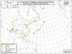
The 1983 Atlantic hurricane season was the least active Atlantic hurricane season in 53 years, with only four tropical storms forming. The season officially began on June 1, 1983, and lasted until November 30, 1983. These dates conventionally delimit the period of each year when most storms...
was the least active Atlantic hurricane season
Atlantic hurricane season
The Atlantic hurricane season is the period in a year when hurricanes usually form in the Atlantic Ocean. Tropical cyclones in the North Atlantic are called hurricanes, tropical storms, or tropical depressions. In addition, there have been several storms over the years that have not been fully...
in 53 years, during which four tropical cyclone
Tropical cyclone
A tropical cyclone is a storm system characterized by a large low-pressure center and numerous thunderstorms that produce strong winds and heavy rain. Tropical cyclones strengthen when water evaporated from the ocean is released as the saturated air rises, resulting in condensation of water vapor...
s formed. The season officially began on June 1, 1983 and ended on November 30, dates which conventionally limit the period of each year when tropical cyclones tend to form in the Atlantic. The first named storm, Hurricane Alicia
Hurricane Alicia
Hurricane Alicia was the costliest tropical cyclone in the Atlantic since Hurricane Agnes in 1972. Alicia was the third depression, the first tropical storm, and the only major hurricane of the 1983 Atlantic hurricane season...
, formed on August 15. The last storm of the season, Tropical Storm Dean, dissipated on September 30. This timeline documents tropical cyclone
Tropical cyclone
A tropical cyclone is a storm system characterized by a large low-pressure center and numerous thunderstorms that produce strong winds and heavy rain. Tropical cyclones strengthen when water evaporated from the ocean is released as the saturated air rises, resulting in condensation of water vapor...
formations, strengthening, weakening, landfalls
Landfall (meteorology)
Landfall is the event of a tropical cyclone or a waterspout coming onto land after being over water. When a waterspout makes landfall it is reclassified as a tornado, which can then cause damage inland...
, extratropical transitions, as well as dissipations during the season. The timeline also includes information which was not operationally released, meaning that information from post-storm reviews by the National Hurricane Center
National Hurricane Center
The National Hurricane Center , located at Florida International University in Miami, Florida, is the division of the National Weather Service responsible for tracking and predicting weather systems within the tropics between the Prime Meridian and the 140th meridian west poleward to the 30th...
, such as information on a storm that was not operationally warned upon.
This season produced seven tropical depressions, of which four became named storms; three attained hurricane status, of which one became a major hurricane
Tropical cyclone scales
Tropical systems are officially ranked on one of several tropical cyclone scales according to their maximum sustained winds and in what oceanic basin they are located...
, a storm that ranks as a Category 3 or higher on the Saffir-Simpson Hurricane Scale
Saffir-Simpson Hurricane Scale
The Saffir–Simpson Hurricane Scale , or the Saffir–Simpson Hurricane Wind Scale , classifies hurricanes — Western Hemisphere tropical cyclones that exceed the intensities of tropical depressions and tropical storms — into five categories distinguished by the intensities of their sustained winds...
. Hurricane Alicia had its name retired due to the fatalities and severe damage caused in Texas. The storm killed 21 people and caused $2.6 billion (1983 USD
United States dollar
The United States dollar , also referred to as the American dollar, is the official currency of the United States of America. It is divided into 100 smaller units called cents or pennies....
; $5.6 billion 2008 USD) in damages, making it the costliest storm, at the time, in Texas history. Hurricane Barry was a weak Category 1 hurricane that traveled almost due west across the Gulf of Mexico for most of its track before making landfall in extreme northern Mexico.
Timeline of storms
Image:1983 ATL timeline.png|
rect 311 26 359 41 Tropical Depression One
rect 325 53 377 68 Tropical Depression Two
rect 392 26 450 40 Hurricane Alicia
Hurricane Alicia
Hurricane Alicia was the costliest tropical cyclone in the Atlantic since Hurricane Agnes in 1972. Alicia was the third depression, the first tropical storm, and the only major hurricane of the 1983 Atlantic hurricane season...
rect 424 54 477 69 Hurricane Barry
Hurricane Barry (1983)
Hurricane Barry was the fourth tropical depression, second hurricane and named storm of the inactive 1983 Atlantic hurricane season. Developing out of a tropical wave on August 23, Barry quickly strengthened off the coast of Florida, reaching an initial peak intensity with winds of 60 mph...
rect 484 81 548 96 Hurricane Chantal
rect 517 26 546 41 Tropical Depression Six
rect 541 53 592 68 Tropical Storm Dean
rect 0 0 799 200 Image:1983 ATL timeline.png
desc none
July
July 23.jpg)
- 8 a.m. ASTUTC-4UTC−04-00 is an identifier for a time offset from UTC of −04.This offset is used in the Atlantic Standard Time Zone in Canada and the North American Eastern Time Zone during daylight saving time , in the Caribbean region this is considered as the Eastern Caribbean timezone...
(1200 UTCCoordinated Universal TimeCoordinated Universal Time is the primary time standard by which the world regulates clocks and time. It is one of several closely related successors to Greenwich Mean Time. Computer servers, online services and other entities that rely on having a universally accepted time use UTC for that purpose...
) – Tropical Depression One forms 955 miles (1,540 km)The figures for maximum sustained windMaximum sustained windThe maximum sustained winds associated with a tropical cyclone are a common indicator of the intensity of the storm. Within a mature tropical cyclone, they are found within the eyewall at a distance defined as the radius of maximum wind, or RMW. Unlike gusts, the value of these winds are...
s and position estimates are rounded to the nearest 5 units (knots, miles, or kilometers), following the convention used in the National Hurricane CenterNational Hurricane CenterThe National Hurricane Center , located at Florida International University in Miami, Florida, is the division of the National Weather Service responsible for tracking and predicting weather systems within the tropics between the Prime Meridian and the 140th meridian west poleward to the 30th...
's operational products for each storm. All other units are rounded to the nearest digit. southwest of Brava, Cape VerdeBrava, Cape VerdeBrava is an island in Cape Verde. It is the smallest inhabited island, but at the same time the greenest, of Cape Verde, in the Sotavento group. First settled in the 1540s, its population grew after Mount Fogo on neighbouring Fogo erupted in 1675...
.
July 27
- 8 a.m. AST (1200 UTC) – Tropical Depression One passes over the island of Saint LuciaSaint LuciaSaint Lucia is an island country in the eastern Caribbean Sea on the boundary with the Atlantic Ocean. Part of the Lesser Antilles, it is located north/northeast of the island of Saint Vincent, northwest of Barbados and south of Martinique. It covers a land area of 620 km2 and has an...
with winds of 35 mph (55 km/h). - 8 a.m. AST (1200 UTC) – Tropical Depression Two forms 245 miles (395 km) southwest of Brava, Cape Verde.
July 28
- 2 p.m. AST (1800 UTC) – Tropical Depression One dissipates over the open waters of the Caribbean SeaCaribbean SeaThe Caribbean Sea is a sea of the Atlantic Ocean located in the tropics of the Western hemisphere. It is bounded by Mexico and Central America to the west and southwest, to the north by the Greater Antilles, and to the east by the Lesser Antilles....
.
August
August 2- 8 a.m. AST (1200 UTC) – Tropical Depression Two dissipates over open waters.
August 15
- 7 a.m. CDT (1200 UTC) – Tropical Depression Three forms 185 miles (295 km) south-southwest of New Orleans, LouisianaLouisianaLouisiana is a state located in the southern region of the United States of America. Its capital is Baton Rouge and largest city is New Orleans. Louisiana is the only state in the U.S. with political subdivisions termed parishes, which are local governments equivalent to counties...
. - 1 p.m. CDT (1800 UTC) – Tropical Depression Three strengthens into Tropical Storm AliciaHurricane AliciaHurricane Alicia was the costliest tropical cyclone in the Atlantic since Hurricane Agnes in 1972. Alicia was the third depression, the first tropical storm, and the only major hurricane of the 1983 Atlantic hurricane season...
.
August 16
- 7 p.m. CDT (0000 UTC August 17) – Tropical Storm Alicia intensifies into a hurricane.
August 17
- 1 p.m. CDT (1800 UTC) – Hurricane Alicia strengthens into a Category 2 hurricane.
August 18
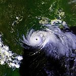
- 1 a.m. CDT (0600 UTC) – Hurricane Alicia strengthens into a major hurricane—a storm with winds of 111 mph (178 km/h) or higher.
- 3 a.m. CDT (0800 UTC) – Hurricane Alicia makes landfall near Galveston, TexasGalveston, TexasGalveston is a coastal city located on Galveston Island in the U.S. state of Texas. , the city had a total population of 47,743 within an area of...
with winds of 115 mph (185 km/h). - 7 a.m. CDT (1200 UTC) – Hurricane Alicia weakens to a Category 1 hurricane.
- 1 p.m. CDT (1800 UTC) – Hurricane Alicia weakens to a tropical storm.
August 19
- 1 a.m. CDT (0600 UTC) – Tropical Storm Alicia weakens to a tropical depression.
August 20
- 1 a.m. CDT (0600 UTC) – Tropical Depression Alicia transitions into an extratropical cycloneExtratropical cycloneExtratropical cyclones, sometimes called mid-latitude cyclones or wave cyclones, are a group of cyclones defined as synoptic scale low pressure weather systems that occur in the middle latitudes of the Earth having neither tropical nor polar characteristics, and are connected with fronts and...
while located over NebraskaNebraskaNebraska is a state on the Great Plains of the Midwestern United States. The state's capital is Lincoln and its largest city is Omaha, on the Missouri River....
.
August 23
- 2 p.m. EDT (1800 UTC) – Tropical Depression Four forms 105 miles (175 km) northeast of Nassau, BahamasNassau, BahamasNassau is the capital, largest city, and commercial centre of the Commonwealth of the Bahamas. The city has a population of 248,948 , 70 percent of the entire population of The Bahamas...
.
August 24
- 2 a.m. EDT (0600 UTC) – Tropical Depression Four strengthens into Tropical Storm BarryHurricane Barry (1983)Hurricane Barry was the fourth tropical depression, second hurricane and named storm of the inactive 1983 Atlantic hurricane season. Developing out of a tropical wave on August 23, Barry quickly strengthened off the coast of Florida, reaching an initial peak intensity with winds of 60 mph...
.
August 25
- 7 a.m. EDT (1100 UTC) – Tropical Storm Barry weakens to a tropical depression and makes landfall near Melbourne, FloridaMelbourne, FloridaMelbourne is a city in Brevard County, Florida, United States. As of 2009, the population estimated by the U.S. Census Bureau is 78,323. The municipal area is the second largest by size and by population in the county. Melbourne is a principal city of the Palm Bay – Melbourne – Titusville, Florida...
with winds of 35 mph (55 km/h).
August 26
.jpg)
- 2 a.m. EDT (0600 UTC) – Tropical Depression Barry emerges into the Gulf of MexicoGulf of MexicoThe Gulf of Mexico is a partially landlocked ocean basin largely surrounded by the North American continent and the island of Cuba. It is bounded on the northeast, north and northwest by the Gulf Coast of the United States, on the southwest and south by Mexico, and on the southeast by Cuba. In...
.
August 27
- 7 a.m. CDT (1200 UTC) – Tropical Depression Barry re-intensifies into a tropical storm.
August 28
- 7 a.m. CDT (1200 UTC) – Tropical Storm Barry strengthens into a hurricane.
- 12:25 CDT (1725 UTC) – Hurricane Barry makes landfall in northern TamaulipasTamaulipasTamaulipas officially Estado Libre y Soberano de Tamaulipas is one of the 31 states which, with the Federal District, comprise the 32 Federal Entities of Mexico. It is divided in 43 municipalities and its capital city is Ciudad Victoria. The capital city was named after Guadalupe Victoria, the...
, MexicoMexicoThe United Mexican States , commonly known as Mexico , is a federal constitutional republic in North America. It is bordered on the north by the United States; on the south and west by the Pacific Ocean; on the southeast by Guatemala, Belize, and the Caribbean Sea; and on the east by the Gulf of...
with winds of 80 mph (130 km/h). - 7 p.m. CDT (0000 UTC August 29) – Hurricane Barry weakens to a tropical storm.
August 29
- 1 a.m. CDT (0600 UTC) – Tropical Storm Barry weakens to a tropical depression.
- 1 p.m. CDT (1800 UTC) – Tropical Depression Barry dissipates over Mexico.
September
September 10- 8 a.m. AST (1200 UTC) – Tropical Depression Five forms 145 miles (235 km) south-southeast of BermudaBermudaBermuda is a British overseas territory in the North Atlantic Ocean. Located off the east coast of the United States, its nearest landmass is Cape Hatteras, North Carolina, about to the west-northwest. It is about south of Halifax, Nova Scotia, Canada, and northeast of Miami, Florida...
. - 8 p.m. AST (0000 UTC September 11) – Tropical Depression Five strengthens into Tropical Storm Chantal.
September 11
- 2 p.m. AST (1800 UTC) – Tropical Storm Chantal intensifies into a hurricane.
September 12
- 8 p.m. AST (0000 UTC September 13) – Hurricane Chantal weakens to a tropical storm.
September 14
- 8 p.m. AST (0000 UTC September 15) – Tropical Storm Chantal weakens to a tropical depression.
September 15
- 8 a.m. AST (1200 UTC) – Tropical Depression Chantal dissipates over open waters.
September 19
- exact time unknown – Tropical Depression Six forms near the Lesser AntillesLesser AntillesThe Lesser Antilles are a long, partly volcanic island arc in the Western Hemisphere. Most of its islands form the eastern boundary of the Caribbean Sea with the Atlantic Ocean, with the remainder located in the southern Caribbean just north of South America...
.
September 21
- exact time unknown – Tropical Depression Six degenerates into a tropical waveTropical waveTropical waves, easterly waves, or tropical easterly waves, also known as African easterly waves in the Atlantic region, are a type of atmospheric trough, an elongated area of relatively low air pressure, oriented north to south, which move from east to west across the tropics causing areas of...
over the Dominican RepublicDominican RepublicThe Dominican Republic is a nation on the island of La Hispaniola, part of the Greater Antilles archipelago in the Caribbean region. The western third of the island is occupied by the nation of Haiti, making Hispaniola one of two Caribbean islands that are shared by two countries...
.
September 26
.jpg)
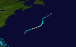
- 2 p.m. EDT (1800 UTC) – Subtropical Storm One forms 335 miles (540 km) northeast of Nassau, Bahamas.
September 27
- 2 p.m. EDT (1800 UTC) – Subtropical Storm One transitions into a tropical cycloneTropical cycloneA tropical cyclone is a storm system characterized by a large low-pressure center and numerous thunderstorms that produce strong winds and heavy rain. Tropical cyclones strengthen when water evaporated from the ocean is released as the saturated air rises, resulting in condensation of water vapor...
and is given the name Dean.
September 30
- 8 a.m. EDT (1200 UTC) – Tropical Storm Dean makes landfall on the Delmarva PeninsulaDelmarva PeninsulaThe Delmarva Peninsula is a large peninsula on the East Coast of the United States, occupied by most of Delaware and portions of Maryland and Virginia...
with winds of 45 mph (75 km/h). - 2 p.m. EDT (1800 UTC) – Tropical Storm Dean weakens to a tropical depression.
- 8 p.m. EDT (0000 UTC October 1) – Tropical Depression Dean dissipates over VirginiaVirginiaThe Commonwealth of Virginia , is a U.S. state on the Atlantic Coast of the Southern United States. Virginia is nicknamed the "Old Dominion" and sometimes the "Mother of Presidents" after the eight U.S. presidents born there...
.