
Geography of the United States Rocky Mountain System
Encyclopedia
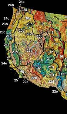 |
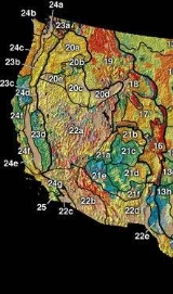
| Physiographic regions of the U.S. Interior See:legend |
For purposes of description, the physical geography
Geography
Geography is the science that studies the lands, features, inhabitants, and phenomena of Earth. A literal translation would be "to describe or write about the Earth". The first person to use the word "geography" was Eratosthenes...
of the United States
United States
The United States of America is a federal constitutional republic comprising fifty states and a federal district...
is split into several major physiographic divisions, one being the Rocky Mountain System. Please refer to the Geography of the United States
Geography of the United States
The United States is a country in the Western Hemisphere. It consists of forty-eight contiguous states in North America, Alaska, a peninsula which forms the northwestern most part of North America, and Hawaii, an archipelago in the Pacific Ocean. There are several United States territories in the...
for the other areas.
Rocky Mountains
The Rocky MountainsRocky Mountains
The Rocky Mountains are a major mountain range in western North America. The Rocky Mountains stretch more than from the northernmost part of British Columbia, in western Canada, to New Mexico, in the southwestern United States...
begin in northern New Mexico, where the axial crystalline rocks rise to 12,000 ft (3,700 m) between the horizontal structures of the plains on the east and the plateaus on the west. The upturned stratified formations wrap around the mountain flanks of the range, with ridges and valleys formed on their eroded edges and drained southward by the Pecos river
Pecos River
The headwaters of the Pecos River are located north of Pecos, New Mexico, United States, at an elevation of over 12,000 feet on the western slope of the Sangre de Cristo mountain range in Mora County. The river flows for through the eastern portion of that state and neighboring Texas before it...
to the Rio Grande
Rio Grande
The Rio Grande is a river that flows from southwestern Colorado in the United States to the Gulf of Mexico. Along the way it forms part of the Mexico – United States border. Its length varies as its course changes...
and the Gulf of Mexico
Gulf of Mexico
The Gulf of Mexico is a partially landlocked ocean basin largely surrounded by the North American continent and the island of Cuba. It is bounded on the northeast, north and northwest by the Gulf Coast of the United States, on the southwest and south by Mexico, and on the southeast by Cuba. In...
. The mountains rapidly grow wider and higher northward, taking on new complications of structure and including large basins between the axes of uplift. In northern Colorado
Colorado
Colorado is a U.S. state that encompasses much of the Rocky Mountains as well as the northeastern portion of the Colorado Plateau and the western edge of the Great Plains...
and Utah, the mountains become a complex of ranges with a breadth of 300 miles (500 km). In Colorado alone, there are 54 summits over 14,000 ft (4,267 m) in altitude, though none rise any higher than Mount Elbert at 14,440 ft (4,399 m). Turning more to the northwest through Wyoming, the ranges decrease in breadth and height. In Montana
Montana
Montana is a state in the Western United States. The western third of Montana contains numerous mountain ranges. Smaller, "island ranges" are found in the central third of the state, for a total of 77 named ranges of the Rocky Mountains. This geographical fact is reflected in the state's name,...
, their breadth is not more than 150 miles (240 km), and only seven summits exceed 11,000 feet (3350 m) with one reaching 12,834 ft (3,912 m).
In general, the peaks in the Rocky Mountains tend to be fairly gentle and rounded relative to those found in other mountain ranges of comparable scale.
Front Range
As far north as the gorge of the MissouriMissouri River
The Missouri River flows through the central United States, and is a tributary of the Mississippi River. It is the longest river in North America and drains the third largest area, though only the thirteenth largest by discharge. The Missouri's watershed encompasses most of the American Great...
river in Montana, the Front Range, facing the Great Plains
Great Plains
The Great Plains are a broad expanse of flat land, much of it covered in prairie, steppe and grassland, which lies west of the Mississippi River and east of the Rocky Mountains in the United States and Canada. This area covers parts of the U.S...
, is a rather simple uplift, usually formed by upturning the flanking strata
Stratum
In geology and related fields, a stratum is a layer of sedimentary rock or soil with internally consistent characteristics that distinguish it from other layers...
, less often by a fault. Along the eastern side of the Rocky Mountains most of the upturned stratified formations have been so well worn down that with exception of a few low piedmont ridges, their even surface may now be included with that of the plains, and the crystalline core of the range is exposed almost to the mountain base. Here, the streams that drain the higher areas descend to the plains through narrow canyons in the mountain border. A well-known example is the gorge of Clear Creek. The crystalline highlands thereabouts, at altitudes of 8000 to 10,000 ft (2,400 to 3,000 m), are of so moderate a relief as to suggest that the mass had stood much lower in a former cycle of erosion and had then been worn down to rounded hills. Since uplift to the present altitude, the revived streams of the current cycle of erosion have not entrenched themselves deep enough to develop strong relief. This idea is confirmed by Pike's Peak
Pikes Peak
Pikes Peak is a mountain in the Front Range of the Rocky Mountains, west of Colorado Springs, Colorado, in El Paso County in the United States of America....
(14,115 ft, 4,300 m), a conspicuous landmark far out on the plains, has every appearance of being a huge monadnock
Monadnock
A monadnock or inselberg is an isolated rock hill, knob, ridge, or small mountain that rises abruptly from a gently sloping or virtually level surrounding plain...
surmounting a rough peneplain
Peneplain
A peneplain is a low-relief plain representing the final stage of fluvial erosion during times of extended tectonic stability. The existence of peneplains, and peneplanation as a geomorphological process, is not without controversy, due to a lack of contemporary examples and uncertainty in...
of 10,000 feet (3,000 m). The idea is still better confirmed farther north in Wyoming
Wyoming
Wyoming is a state in the mountain region of the Western United States. The western two thirds of the state is covered mostly with the mountain ranges and rangelands in the foothills of the Eastern Rocky Mountains, while the eastern third of the state is high elevation prairie known as the High...
, where the Laramie Mountains
Laramie Mountains
The Laramie Mountains are a range of moderately high peaks on the eastern edge of the Rocky Mountains in the U.S states of Wyoming and Colorado. The range is the northernmost extension of the line of the ranges along the eastern side of the Rockies, and in particular of the higher peaks of the...
, flanked with upturned strata on the east and west, are for the most part a broad upland at altitudes of 7000 to 8000 feet (2,100 to 2,400 m) with no strong surmounting summits and yet no deep carved valleys. Here the first of the Pacific railways chose its pass. From the summit, there is very little relief of the upland surface. This low range turns westward in a curve through the Rattlesnake Mountains towards the high Wind River Mountains (Gannett Peak
Gannett Peak
Gannett Peak is the highest peak in the U.S. state of Wyoming and straddles the boundary between Fremont and Sublette Counties along the Continental Divide.- Overview :...
, 13,804 ft, 4,1207 m). This is an anticlinal
Anticline
In structural geology, an anticline is a fold that is convex up and has its oldest beds at its core. The term is not to be confused with antiform, which is a purely descriptive term for any fold that is convex up. Therefore if age relationships In structural geology, an anticline is a fold that is...
range within the body of the mountain system with flanking strata rising well on the slopes. Flanking strata are even better exhibited in the Bighorn Mountains, the front range of northern Wyoming. They are crescent in outline and convex to the northeast, like the Laramie Range, but much higher. Here, heavy sheets of limestone
Limestone
Limestone is a sedimentary rock composed largely of the minerals calcite and aragonite, which are different crystal forms of calcium carbonate . Many limestones are composed from skeletal fragments of marine organisms such as coral or foraminifera....
arch far up towards the range crest and are deeply notched where consequent streams have cut down their gorges.
Farther north in Montana, beyond the gorge of the Missouri river, the
structure of the Front Range is altogether different. It is the carved
residual of a great mass of moderately folded
Fold (geology)
The term fold is used in geology when one or a stack of originally flat and planar surfaces, such as sedimentary strata, are bent or curved as a result of permanent deformation. Synsedimentary folds are those due to slumping of sedimentary material before it is lithified. Folds in rocks vary in...
Palaeozoic strata. These strata have overthrust
Thrust fault
A thrust fault is a type of fault, or break in the Earth's crust across which there has been relative movement, in which rocks of lower stratigraphic position are pushed up and over higher strata. They are often recognized because they place older rocks above younger...
eastward upon the Mesozoic
Mesozoic
The Mesozoic era is an interval of geological time from about 250 million years ago to about 65 million years ago. It is often referred to as the age of reptiles because reptiles, namely dinosaurs, were the dominant terrestrial and marine vertebrates of the time...
strata of the plains. Instead of exposing the oldest rocks along the axis and the youngest rocks low down on the flanks, the younger rocks of the northern range follow its axis, while the oldest rocks outcrop along its eastern flanks. There, they override the much younger strata of the plains. The harder strata, instead of lapping on the mountain flanks in great slab-like masses, as in the Bighorns, form out-facing scarps, which retreat into the mountain interior where they are cut down by outflowing streams.
Inner ranges
The structure of the inner ranges is so variable as to elude simpledescription. The Uinta
Uinta Mountains
The Uinta Mountains are a high chain of mountains in northeastern Utah and extreme northwestern Colorado in the United States. A subrange of the Rocky Mountains, they are unusual for being the highest range in the contiguous United States running east to west, and lie approximately east of Salt...
range is a broad anticlinal structure in northeast Utah with east-west trend corresponding to the east-west Rattlesnake Mountains mentioned earlier. The Wasatch Range
Wasatch Range
The Wasatch Range is a mountain range that stretches approximately from the Utah-Idaho border, south through central Utah in the western United States. It is generally considered the western edge of the greater Rocky Mountains, and the eastern edge of the Great Basin region...
, trending north-south in central Utah, is peculiar in possessing large east-west folds which are seen in cross-section in the dissected western face of the range. It is visible because the whole mass is squarely cut off by a great north-south fault, the Wasatch Fault
Wasatch Fault
The Wasatch Fault is an earthquake fault located primarily on the western edge of the Wasatch Mountains in the U.S. state of Utah. The fault is 240 miles long, stretching from southern Idaho, through northern Utah, before terminating in central Utah near the town of Fayette...
, with down-throw to the Basin and Range
Basin and Range
The Basin and Range Province is a vast physiographic region defined by a unique topographic expression. Basin and Range topography is characterized by abrupt changes in elevation, alternating between narrow faulted mountain chains and flat arid valleys or basins...
province.
Volcanism
Volcanic action has been limited in the Rocky Mountains proper. West Spanish PeakWest Spanish Peak
West Spanish Peak is a high mountain peak in the US state of Colorado. It is the higher of the two Spanish Peaks, two large igneous stocks which form an eastern outlier of the Culebra Range, a subrange of the Sangre de Cristo Mountains...
(13,626 ft, 4,153 m), in the Front Range of southern Colorado, may be mentioned as an example of a deeply dissected volcano
Volcano
2. Bedrock3. Conduit 4. Base5. Sill6. Dike7. Layers of ash emitted by the volcano8. Flank| 9. Layers of lava emitted by the volcano10. Throat11. Parasitic cone12. Lava flow13. Vent14. Crater15...
, originally of greater height, with many unusually strong radiating dike
Dike (geology)
A dike or dyke in geology is a type of sheet intrusion referring to any geologic body that cuts discordantly across* planar wall rock structures, such as bedding or foliation...
-ridges near its denuded flanks. In north-western Wyoming, there are extensive lava
Lava
Lava refers both to molten rock expelled by a volcano during an eruption and the resulting rock after solidification and cooling. This molten rock is formed in the interior of some planets, including Earth, and some of their satellites. When first erupted from a volcanic vent, lava is a liquid at...
sheets, uplifted and dissected, and crowned with a few dissected volcanoes. Associated with this is a remarkable group of geyser
Geyser
A geyser is a spring characterized by intermittent discharge of water ejected turbulently and accompanied by a vapour phase . The word geyser comes from Geysir, the name of an erupting spring at Haukadalur, Iceland; that name, in turn, comes from the Icelandic verb geysa, "to gush", the verb...
s and hot spring
Hot spring
A hot spring is a spring that is produced by the emergence of geothermally heated groundwater from the Earth's crust. There are geothermal hot springs in many locations all over the crust of the earth.-Definitions:...
s in Yellowstone National Park
Yellowstone National Park
Yellowstone National Park, established by the U.S. Congress and signed into law by President Ulysses S. Grant on March 1, 1872, is a national park located primarily in the U.S. state of Wyoming, although it also extends into Montana and Idaho...
from which the Yellowstone River
Yellowstone River
The Yellowstone River is a tributary of the Missouri River, approximately long, in the western United States. Considered the principal tributary of the upper Missouri, the river and its tributaries drain a wide area stretching from the Rocky Mountains in the vicinity of the Yellowstone National...
, a branch of the Missouri
Missouri River
The Missouri River flows through the central United States, and is a tributary of the Mississippi River. It is the longest river in North America and drains the third largest area, though only the thirteenth largest by discharge. The Missouri's watershed encompasses most of the American Great...
, flows northeastward, and the Snake River
Snake River
The Snake is a major river of the greater Pacific Northwest in the United States. At long, it is the largest tributary of the Columbia River, the largest North American river that empties into the Pacific Ocean...
, a branch of the Columbia
Columbia River
The Columbia River is the largest river in the Pacific Northwest region of North America. The river rises in the Rocky Mountains of British Columbia, Canada, flows northwest and then south into the U.S. state of Washington, then turns west to form most of the border between Washington and the state...
, flows southwestward.
Glacial features
The central and southern ranges of the Rocky Mountains are not like the abnormally sharpened peaks found in the ice-sculptured AlpsAlps
The Alps is one of the great mountain range systems of Europe, stretching from Austria and Slovenia in the east through Italy, Switzerland, Liechtenstein and Germany to France in the west....
. Many of these ranges are characterized by the rounded tops and the rather evenly slanting, waste-covered slopes which normally result from the long-continued action of the ordinary agencies of erosion. They bear little snow in summer and few if any glaciers. The forests are often scanty on the middle and lower slopes. The general impression of great altitude is much weakened because the mountains are seen from a base which itself is 5000 to 6000 feet (1,500 to 1,800 m) above sea level. Travelling along the range from south to north reveals most strikingly a gradual increase in the share of sculpture due to Pleistocene
Pleistocene
The Pleistocene is the epoch from 2,588,000 to 11,700 years BP that spans the world's recent period of repeated glaciations. The name pleistocene is derived from the Greek and ....
glacier
Glacier
A glacier is a large persistent body of ice that forms where the accumulation of snow exceeds its ablation over many years, often centuries. At least 0.1 km² in area and 50 m thick, but often much larger, a glacier slowly deforms and flows due to stresses induced by its weight...
s. In New Mexico, if glaciers were formed at all in the high valleys, they were so small as not to greatly to modify the more normal forms. In central Colorado and Wyoming, where the mountains are higher and the Pleistocene glaciers were larger, the valley heads were hollowed out in well-formed cirques
Cirque (landform)
thumb|250 px|Two cirques with semi-permanent snowpatches in [[Abisko National Park]], [[Sweden]].A cirque or corrie is an amphitheatre-like valley head, formed at the head of a valley glacier by erosion...
, often holding small lakes. The mountain valleys were enlarged into U-shaped troughs as far down as the ice reached, with hanging lateral valleys on the way. Different stages of cirque development, with accompanying transformations of mountain shape, are finely illustrated in several ranges around the headwaters of the Arkansas River
Arkansas River
The Arkansas River is a major tributary of the Mississippi River. The Arkansas generally flows to the east and southeast as it traverses the U.S. states of Colorado, Kansas, Oklahoma, and Arkansas. The river's initial basin starts in the Western United States in Colorado, specifically the Arkansas...
in central Colorado, where the highest summit of the Rocky Mountains is found (Mt. Elbert, 14,433 ft (4,399 m), in the Sawatch Mountains). Perhaps even better illustrated in the Bighorn range of Wyoming. In this central region, it is the exception rather than the rule that the cirques were enlarged enough by retrogressive glacial erosion as to sharpen the preglacial dome-like summits into acute peaks. In no case did glacial action here extend down to the plains at the eastern base of the mountains. However, the widened, trough-like glaciated valleys frequently descend to the level of the elevated intermontane
Intermontane
Intermontane is a physiographic adjective formed from the prefix "inter-" and the adjective "montane" Usage includes intermontane basin such as New Zealand's Mackenzie Basin and intermontane...
basins, where moraine
Moraine
A moraine is any glacially formed accumulation of unconsolidated glacial debris which can occur in currently glaciated and formerly glaciated regions, such as those areas acted upon by a past glacial maximum. This debris may have been plucked off a valley floor as a glacier advanced or it may have...
s were deployed forward on the basin floor. The finest examples of this kind are the moraine
Moraine
A moraine is any glacially formed accumulation of unconsolidated glacial debris which can occur in currently glaciated and formerly glaciated regions, such as those areas acted upon by a past glacial maximum. This debris may have been plucked off a valley floor as a glacier advanced or it may have...
s about Jackson Lake on the basin floor east of the Teton Mountains (Grand Teton
Grand Teton
Grand Teton is the highest mountain in Wyoming's Grand Teton National Park, and a classic destination in American mountaineering.- Geography :...
, 13,747 ft, 4,190 m). This superb north-south range lies close to the meridional boundary line between Wyoming and Idaho
Idaho
Idaho is a state in the Rocky Mountain area of the United States. The state's largest city and capital is Boise. Residents are called "Idahoans". Idaho was admitted to the Union on July 3, 1890, as the 43rd state....
. Farther north in Montana, in spite of a decrease of height, there are today a few small glaciers with snowfields of good size. Here the effects of sculpture by the much larger
Pleistocene glaciers are seen in forms almost as exaggerated as the Alps.
Intermontane basins
The intermontane basins which so strongly characterize the Rocky Mountain system are areas which have been less uplifted than the enclosing ranges. They have usually become the depositories of sediments from the surrounding mountains. Some of the most important basins are:- the San Luis ValleySan Luis ValleyThe San Luis Valley is an extensive alpine valley in the U.S. states of Colorado and New Mexico covering approximately and sitting at an average elevation of above sea level. The valley sits atop the Rio Grande Rift and is drained to the south by the Rio Grande River, which rises in the San Juan...
- basin near the Royal GorgeRoyal GorgeThe Royal Gorge is a canyon on the Arkansas River near Cañon City, Colorado. With a width of at its base and a few hundred feet at its top, and a depth of in places, the 10-mile-long canyon is a narrow, steep gorge through the granite of Fremont Peak...
- South Park Basin
- Bighorn BasinBighorn BasinThe Bighorn Basin is a plateau region and intermontane basin, approximately 100 miles wide, in north-central Wyoming in the United States. It is bounded by the Absaroka Range on the west, the Bighorn Mountains on the east, and the Owl Creek Mountains and Bridger Mountains on the south...
San Luis Valley is an oval basin about 60 miles (100 km) long near the southern end of the mountain system in New Mexico and Colorado. Its level, treeless floor, at an altitude of 7000 feet (2,100 m), is as yet hardly trenched by the Rio Grande, which escapes through an impassable canyon southward on its way to the Gulf of Mexico
Gulf of Mexico
The Gulf of Mexico is a partially landlocked ocean basin largely surrounded by the North American continent and the island of Cuba. It is bounded on the northeast, north and northwest by the Gulf Coast of the United States, on the southwest and south by Mexico, and on the southeast by Cuba. In...
. The much smaller basin of the upper Arkansas river in Colorado is well known because the Royal Gorge
Royal Gorge
The Royal Gorge is a canyon on the Arkansas River near Cañon City, Colorado. With a width of at its base and a few hundred feet at its top, and a depth of in places, the 10-mile-long canyon is a narrow, steep gorge through the granite of Fremont Peak...
, a very narrow cleft by which the river escapes through the Front Range to the plains, is followed by a railroad at river level. South Park, directly west of Pike's Peak, is one of the highest basins (nearly 10,000 ft or 3,000 m), and gains its name from the scattered, park-like growth of large pine trees. It is drained chiefly by the South Platte River
Platte River
The Platte River is a major river in the state of Nebraska and is about long. Measured to its farthest source via its tributary the North Platte River, it flows for over . The Platte River is a tributary of the Missouri River, which in turn is a tributary of the Mississippi River which flows to...
Missouri-Mississippi
Mississippi River
The Mississippi River is the largest river system in North America. Flowing entirely in the United States, this river rises in western Minnesota and meanders slowly southwards for to the Mississippi River Delta at the Gulf of Mexico. With its many tributaries, the Mississippi's watershed drains...
system), through a deep gorge in the dissected mass of the plateau-like Front Range.
The Laramie Plains and the Green River
Green River (Utah)
The Green River, located in the western United States, is the chief tributary of the Colorado River. The watershed of the river, known as the Green River Basin, covers parts of Wyoming, Utah, and Colorado. The Green River is long, beginning in the Wind River Mountains of Wyoming and flowing...
basin, essentially a single structural basin between the east-west ranges of the Rattlesnake Mountains on the north and the Uinta Range on the south, measuring roughly 260 miles (420 km) east-west by 200 miles (320 km) north-south, make up the largest intermontane basin. It is well known from being traversed through most of its length by the Union Pacific Railroad
Union Pacific Railroad
The Union Pacific Railroad , headquartered in Omaha, Nebraska, is the largest railroad network in the United States. James R. Young is president, CEO and Chairman....
. Its eastern part is drained northeastward through a gorge that separates the Laramie and Rattlesnake (Front) ranges by the North Platte River
Platte River
The Platte River is a major river in the state of Nebraska and is about long. Measured to its farthest source via its tributary the North Platte River, it flows for over . The Platte River is a tributary of the Missouri River, which in turn is a tributary of the Mississippi River which flows to...
to the Missouri-Mississippi. Its western part, where the basin floor is much dissected, is drained southward by the Green River through a deep canyon in the Uinta Range to the Colorado River and then to the Pacific Ocean. The Bighorn basin has a moderately dissected floor, drained northeastward by Bighorn River through a deep canyon in the range of the same name to the Missouri. Several smaller basins occur in Montana, all somewhat dissected and drained through narrow gorges and canyons by members of the Missouri system.