
West Spanish Peak
Encyclopedia
West Spanish Peak is a high mountain peak in the US state of Colorado
. It is the higher of the two Spanish Peaks
, two large igneous stock
s which form an eastern outlier of the Culebra Range, a subrange of the Sangre de Cristo Mountains
. Though not a fourteener
, it is the twelfth most topographically prominent
peak in the state.
West Spanish Peak is the easternmost 4000 meter (13,123 ft) mountain peak in the United States. Due to its position well east of the Culebra Range and on the edge of the eastern plains of Colorado, West Spanish Peak enjoys great local vertical relief in almost all directions. For example, it rises over 6,000 ft (1,828 m) in less than 6.5 miles (10.5 km) on both its north and south flanks.
 While the Spanish Peaks have the appearance of volcanic cones, they are actually stock
s, remnants of an igneous batholith
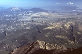
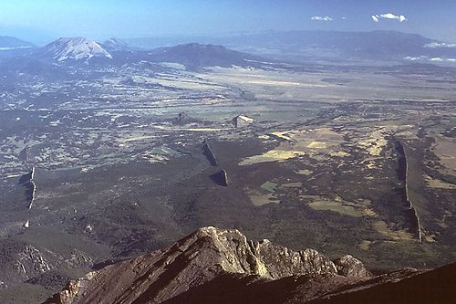
which formed underground around 25 million years ago. They are surrounded by radiating dike
s, up to 14 miles (22 km) long, made of the same material.
, a high pass (11,248 ft/3,428 m) to the west of the peak. It follows a trail for about 2 miles (3.2 km) to treeline. From there there's a rough path on talus (scree
) up the southwest ridge of the peak for an additional 1.5 miles (2.4 km). The trail is very braided and has a tendency to "go to the right" (which is into loose scree). If climbers stay to the left and close to the ridge, the climbing is much easier. At about 13,000' is a large shale buttress to the right that usually has a small pool of warm water at its foot. Once up on the main part of the top ridge, it's an easy hike to the actual summit. The top ridge tends to be 30–100 feet (10-30m) wide and is about .5 miles (.8 km) long before beginning a significant downward trend on the east side of the mountain. To the north and south are very steep descents. At the summit is a large rock cairn with the usual PVC tube and "sign-in" sheet inside. This mountain is very unsafe when there is snow on the ground. Best time to climb: early June through late October. Thunderstorm and lightning activity can be high in July, August and September.
Colorado
Colorado is a U.S. state that encompasses much of the Rocky Mountains as well as the northeastern portion of the Colorado Plateau and the western edge of the Great Plains...
. It is the higher of the two Spanish Peaks
Spanish Peaks
The Spanish Peaks are a pair of volcanic mountains located in southwestern Huerfano County, Colorado. The Ute indians named them Huajatolla , meaning "two breasts". The Spanish name translates as "Breasts of the Earth". The two peaks, West Spanish Peak and East Spanish Peak, are the easternmost...
, two large igneous stock
Intrusion
An intrusion is liquid rock that forms under Earth's surface. Magma from under the surface is slowly pushed up from deep within the earth into any cracks or spaces it can find, sometimes pushing existing country rock out of the way, a process that can take millions of years. As the rock slowly...
s which form an eastern outlier of the Culebra Range, a subrange of the Sangre de Cristo Mountains
Sangre de Cristo Mountains
The Sangre de Cristo Mountains are the southernmost subrange of the Rocky Mountains. They are located in southern Colorado and northern New Mexico in the United States...
. Though not a fourteener
Fourteener
In mountaineering terminology in the United States, a fourteener is a mountain that exceeds 14,000 feet above mean sea level. There are 547 fourteeners in the world. The importance of fourteeners is greatest in Colorado, which has the majority of such peaks in North America...
, it is the twelfth most topographically prominent
Topographic prominence
In topography, prominence, also known as autonomous height, relative height, shoulder drop , or prime factor , categorizes the height of the mountain's or hill's summit by the elevation between it and the lowest contour line encircling it and no higher summit...
peak in the state.
West Spanish Peak is the easternmost 4000 meter (13,123 ft) mountain peak in the United States. Due to its position well east of the Culebra Range and on the edge of the eastern plains of Colorado, West Spanish Peak enjoys great local vertical relief in almost all directions. For example, it rises over 6,000 ft (1,828 m) in less than 6.5 miles (10.5 km) on both its north and south flanks.
Geology
Intrusion
An intrusion is liquid rock that forms under Earth's surface. Magma from under the surface is slowly pushed up from deep within the earth into any cracks or spaces it can find, sometimes pushing existing country rock out of the way, a process that can take millions of years. As the rock slowly...
s, remnants of an igneous batholith
Batholith
A batholith is a large emplacement of igneous intrusive rock that forms from cooled magma deep in the Earth's crust...
which formed underground around 25 million years ago. They are surrounded by radiating dike
Dike (geology)
A dike or dyke in geology is a type of sheet intrusion referring to any geologic body that cuts discordantly across* planar wall rock structures, such as bedding or foliation...
s, up to 14 miles (22 km) long, made of the same material.
Hiking/climbing
The standard ascent route for West Spanish Peak starts at Cordova PassCordova Pass (Colorado)
Cordova Pass lies on the western shoulder of the West Spanish Peak, east of the Culebra Range of the Sangre de Cristo Mountains in southern Colorado. Cordova Pass lies just outside the Spanish Peaks Wilderness, a designated National Wilderness Area on the San Isabel National Forest...
, a high pass (11,248 ft/3,428 m) to the west of the peak. It follows a trail for about 2 miles (3.2 km) to treeline. From there there's a rough path on talus (scree
Scree
Scree, also called talus, is a term given to an accumulation of broken rock fragments at the base of crags, mountain cliffs, or valley shoulders. Landforms associated with these materials are sometimes called scree slopes or talus piles...
) up the southwest ridge of the peak for an additional 1.5 miles (2.4 km). The trail is very braided and has a tendency to "go to the right" (which is into loose scree). If climbers stay to the left and close to the ridge, the climbing is much easier. At about 13,000' is a large shale buttress to the right that usually has a small pool of warm water at its foot. Once up on the main part of the top ridge, it's an easy hike to the actual summit. The top ridge tends to be 30–100 feet (10-30m) wide and is about .5 miles (.8 km) long before beginning a significant downward trend on the east side of the mountain. To the north and south are very steep descents. At the summit is a large rock cairn with the usual PVC tube and "sign-in" sheet inside. This mountain is very unsafe when there is snow on the ground. Best time to climb: early June through late October. Thunderstorm and lightning activity can be high in July, August and September.
See also
- Colorado 4000 meter peaks
- Culebra Range
- Mountain peaks of ColoradoMountain peaks of ColoradoThis article comprises three sortable tables of the major mountain peaks of the U.S. State of Colorado.Topographic elevation is the vertical distance above the reference geoid, a precise mathematical model of the Earth's sea level as an equipotential gravitational surface...
- Mountain peaks of North AmericaMountain peaks of North AmericaThis article comprises three sortable tables of major mountain peaks of greater North America.This article defines greater North America as the portion of the continental landmass of the Americas extending northward from Panama plus the islands surrounding that landmass...
- Mountain peaks of the Rocky MountainsMountain peaks of the Rocky MountainsThis article comprises three sortable tables of major mountain peaks of the Rocky Mountains of North America.Topographic elevation is the vertical distance above the reference geoid, a precise mathematical model of the Earth's sea level as an equipotential gravitational surface...
- Mountain peaks of the United StatesMountain peaks of the United StatesThis article comprises three sortable tables of the major mountain peaks of the United States of America.Topographic elevation is the vertical distance above the reference geoid, a precise mathematical model of the Earth's sea level as an equipotential gravitational surface...
- Mountain ranges of ColoradoMountain ranges of ColoradoThe following table lists the major mountain ranges of the U.S. State of Colorado.-Mountain Ranges:-See also:*4000 meter peaks of Colorado*Colorado mountain passes*Geography of Colorado*Lists of mountains*Mountain peaks of Colorado...
- Sangre de Cristo MountainsSangre de Cristo MountainsThe Sangre de Cristo Mountains are the southernmost subrange of the Rocky Mountains. They are located in southern Colorado and northern New Mexico in the United States...
- Southern Rocky MountainsSouthern Rocky MountainsThe Southern Rocky Mountains are a major subregion of the Rocky Mountains of North America located in the southern portion of the U.S. state of Wyoming, the central and western portions of Colorado, the northern portion of New Mexico, and extreme eastern portions of Utah...
- Spanish PeaksSpanish PeaksThe Spanish Peaks are a pair of volcanic mountains located in southwestern Huerfano County, Colorado. The Ute indians named them Huajatolla , meaning "two breasts". The Spanish name translates as "Breasts of the Earth". The two peaks, West Spanish Peak and East Spanish Peak, are the easternmost...
- ThirteenerThirteenerIn mountaineering in the United States, a thirteener is a mountain that exceeds above mean sea level, similar to the more familiar "fourteeners," which exceed...