

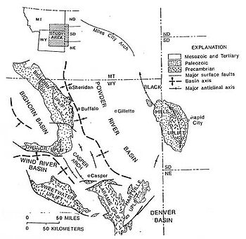
Bighorn Basin
Encyclopedia

Plateau
In geology and earth science, a plateau , also called a high plain or tableland, is an area of highland, usually consisting of relatively flat terrain. A highly eroded plateau is called a dissected plateau...
region and intermontane
Intermontane
Intermontane is a physiographic adjective formed from the prefix "inter-" and the adjective "montane" Usage includes intermontane basin such as New Zealand's Mackenzie Basin and intermontane...
basin, approximately 100 miles (160 km) wide, in north-central Wyoming
Wyoming
Wyoming is a state in the mountain region of the Western United States. The western two thirds of the state is covered mostly with the mountain ranges and rangelands in the foothills of the Eastern Rocky Mountains, while the eastern third of the state is high elevation prairie known as the High...
in the United States
United States
The United States of America is a federal constitutional republic comprising fifty states and a federal district...
. It is bounded by the Absaroka Range
Absaroka Range
The Absaroka Range is a sub-range of the Rocky Mountains in the United States. The range stretches about 150 mi across the Montana-Wyoming border, forming the eastern boundary of Yellowstone National Park and the western side of the Bighorn Basin. The range borders the Beartooth Mountains...
on the west, the Bighorn Mountains on the east, and the Owl Creek Mountains
Owl Creek Mountains
The Owl Creek Mountains are a subrange of the Rocky Mountains in central Wyoming in the United States, running east to west to form a bridge between the Absaroka Range to the northwest and the Bridger Mountains to the east. The range forms the boundary between the Bighorn Basin to the north and the...
and Bridger Mountains
Bridger Mountains (Wyoming)
The Bridger Mountains are a short subrange of the Rocky Mountains, approximately long, in central Wyoming in the United States. The range forms a bridge between the Owl Creek Mountains to the west and the southern end of the Bighorn Mountains to the east. The Wind River passes through the gap...
on the south. It is drained to the north by tributaries of the Bighorn River
Bighorn River
The Bighorn River is a tributary of the Yellowstone, approximately long, in the western United States in the states of Wyoming and Montana. The river was named in 1805 by fur trader François Larocque for the Bighorn Sheep he saw along its banks as he explored the Yellowstone River.The upper...
, which enters the basin from the south, through a gap between the Owl Creek and Bridger Mountains, as the Wind River
Wind River (Wyoming)
The Wind River is the name applied to the upper reaches of the Bighorn River in Wyoming in the United States. The Wind River is long. The two rivers are sometimes referred to as the Wind/Bighorn.-Course:...
, and becomes the Bighorn as it enters the basin. The region is semi-arid, receiving only 6–10 in (15–25 cm) of rain annually.
The largest cities in the basin include the Wyoming towns of Cody
Cody, Wyoming
Cody is a city in Park County, Wyoming, United States. It is named after William Frederick Cody, primarily known as Buffalo Bill, from William Cody's part in the creation of the original town. The population was 9,520 at the 2010 census...
, Thermopolis
Thermopolis, Wyoming
Thermopolis is the largest town in, and the county seat of Hot Springs County, Wyoming, United States. As of the 2000 census, the town population was 3,172....
, Worland
Worland, Wyoming
Worland is a city in Washakie County, Wyoming, United States. The population was 5,250 at the 2000 census. It is the county seat of Washakie County. The City of Worland is served by the Worland Municipal Airport.-Geography:...
, and Powell
Powell, Wyoming
Powell is a city in Park County, Wyoming, United States. The population was 5,373 at the 2000 census. Powell is an All-America City and home to Northwest College.-Geography:Powell is located at ....
. Sugar beet
Sugar beet
Sugar beet, a cultivated plant of Beta vulgaris, is a plant whose tuber contains a high concentration of sucrose. It is grown commercially for sugar production. Sugar beets and other B...
s are grown on irrigated farms in the region.
History
The basin was explored by John ColterJohn Colter
John Colter was a member of the Lewis and Clark Expedition . Though party to one of the more famous expeditions in history, Colter is best remembered for explorations he made during the winter of 1807–1808, when Colter became the first known person of European descent to enter the region now known...
in 1807. Just west of Cody, he discovered geothermal features that were later popularly called "Colter's Hell
Colter's Hell
Colter's Hell is an area of fumaroles and hot springs on the Shoshone River near Cody in the US state of Wyoming. The thermal area covers about a square mile at the mouth of the Shoshone's canyon. Its thermal activity has declined ever since its description by mountain man John Colter, who passed...
". The region was later transversed by the Bridger Trail
Bridger Trail
The Bridger Trail was an overland route connecting the Oregon Trail to the gold fields of Montana. Gold was discovered in Virginia City, Montana in 1863, prompting settlers and prospectorsto find a trail to travel from central Wyoming to Montana...
, which was blazed in 1864 by Jim Bridger
Jim Bridger
James Felix "Jim" Bridger was among the foremost mountain men, trappers, scouts and guides who explored and trapped the Western United States during the decades of 1820-1850, as well as mediating between native tribes and encroaching whites...
to connect the Oregon Trail
Oregon Trail
The Oregon Trail is a historic east-west wagon route that connected the Missouri River to valleys in Oregon and locations in between.After 1840 steam-powered riverboats and steamboats traversing up and down the Ohio, Mississippi and Missouri rivers sped settlement and development in the flat...
to the south with Montana
Montana
Montana is a state in the Western United States. The western third of Montana contains numerous mountain ranges. Smaller, "island ranges" are found in the central third of the state, for a total of 77 named ranges of the Rocky Mountains. This geographical fact is reflected in the state's name,...
. The route was an important alternative to the Bozeman Trail
Bozeman Trail
The Bozeman Trail was an overland route connecting the gold rush territory of Montana to the Oregon Trail. Its most important period was from 1863-1868. The flow of pioneers and settlers through territory of American Indians provoked their resentment and caused attacks. The U.S. Army undertook...
, which had crossed the Powder River Country
Powder River Country
The Powder River Country refers to an area of the Great Plains in northeastern Wyoming in the United States. The area is loosely defined between the Bighorn Mountains and the Black Hills, in the upper drainage areas of the Powder, Tongue, and Little Bighorn rivers.During the late 1860s, the area...
, but had been closed to white settlers following Red Cloud's War
Red Cloud's War
Red Cloud's War was an armed conflict between the Lakota, Northern Cheyenne, and Arapaho and the United States in the Wyoming Territory and the Montana Territory from 1866 to 1868. The war was fought over control of the Powder River Country in north central present day Wyoming...
. Around the turn of the 20th century the Bighorn Basin was settled by ranchers such as William "Buffalo Bill" Cody
Buffalo Bill
William Frederick "Buffalo Bill" Cody was a United States soldier, bison hunter and showman. He was born in the Iowa Territory , in LeClaire but lived several years in Canada before his family moved to the Kansas Territory. Buffalo Bill received the Medal of Honor in 1872 for service to the US...
who founded the town of Cody and owned a great deal of land surrounding the Shoshone River
Shoshone River
The Shoshone River is long river in northern Wyoming in the United States. Its headwaters are in the Absaroka Range in Shoshone National Forest. It ends when it runs into the Big Horn River near Lovell, Wyoming. Cities it runs near or through are Cody, Powell, Byron, and Lovell. Near Cody, it...
. In 1904, Cody helped to form the Shoshone project
Shoshone project
The Shoshone Project is an irrigation project in the U.S. state of Wyoming. The project provides irrigation for approximately of crops in the Big Horn Basin, fulfilling the vision of local resident and developer Buffalo Bill Cody, who hoped to make the semi-arid basin into agricultural land...
, the nation's first federal water development project to help irrigate the western portion of the basin. The project culminated in the construction of the Buffalo Bill Dam
Buffalo Bill Dam
Buffalo Bill Dam is a concrete arch-gravity dam on the Shoshone River in the U.S. state of Wyoming. The dam is named after the famous old West figure William "Buffalo Bill" Cody who founded the nearby town of Cody and who owned much of the land now covered by the reservoir formed by the dam, which...
and reservoir. The wealth in the region also attracted outlaws. Butch Cassidy
Butch Cassidy
Robert LeRoy Parker , better known as Butch Cassidy, was a notorious American train robber, bank robber, and leader of the Wild Bunch Gang in the American Old West...
lived near Meeteetse
Meeteetse, Wyoming
Meeteetse is a town in Park County, Wyoming, United States. The population was 351 at the 2000 census.-Geography:Meeteetse is located at ....
for a while and was arrested at the insistence of local cattle baron Otto Franc
Otto Franc
Count Otto Franc von Lichtenstein was a cattle baron, sheriff and judge in the Big Horn Basin region of the U.S. State of Wyoming. Franc was born in Germany as a member of the German nobility. He emigrated to the United States in 1866...
and sent to the Wyoming State Penitentiary for horse theft. Following his release, he formed the Wild Bunch
Wild Bunch
The Wild Bunch, also known as the Doolin–Dalton Gang or the Oklahombres, was a gang of outlaws based in the Indian Territory that terrorized Kansas, Missouri, Arkansas, and Oklahoma Territory during the 1890s—robbing banks and stores, holding up trains, and killing lawmen. They were...
gang which operated from the Hole-in-the-Wall
Hole-in-the-Wall
Hole-in-the-Wall is a remote hideout located in the Big Horn Mountains of Johnson County in northern Wyoming. The site was used in the late 19th century by the Hole in the Wall Gang, a group of cattle rustlers and other outlaws which included Kid Curry, Black Jack Ketchum, and Butch Cassidy's Wild...
area southeast of the Bighorn Basin.
In 1942 one of the nation's ten Japanese American
Japanese American
are American people of Japanese heritage. Japanese Americans have historically been among the three largest Asian American communities, but in recent decades have become the sixth largest group at roughly 1,204,205, including those of mixed-race or mixed-ethnicity...
internment camps was located in Park County in the western part of the basin. The camp was named Heart Mountain War Relocation Center, after nearby Heart Mountain
Heart Mountain (Wyoming)
Heart Mountain is an 8,123-foot klippe just north of Cody in the U.S. state of Wyoming, sticking up from the floor of the Bighorn Basin...
. The camp operated until 1945, and at its peak detained over 10,000 internees.
Geology
Cambrian
The Cambrian is the first geological period of the Paleozoic Era, lasting from Mya ; it is succeeded by the Ordovician. Its subdivisions, and indeed its base, are somewhat in flux. The period was established by Adam Sedgwick, who named it after Cambria, the Latin name for Wales, where Britain's...
to Miocene
Miocene
The Miocene is a geological epoch of the Neogene Period and extends from about . The Miocene was named by Sir Charles Lyell. Its name comes from the Greek words and and means "less recent" because it has 18% fewer modern sea invertebrates than the Pliocene. The Miocene follows the Oligocene...
in age. Since the early 20th century the basin has been a significant source of petroleum, and has produced more than 1400000000 barrels (222,582,213,000 l) of oil. The principal source of oil is the Pennsylvanian
Pennsylvanian
The Pennsylvanian is, in the ICS geologic timescale, the younger of two subperiods of the Carboniferous Period. It lasted from roughly . As with most other geochronologic units, the rock beds that define the Pennsylvanian are well identified, but the exact date of the start and end are uncertain...
Tensleep Formation; Other important petroleum horizons are the Mississippian Madison Limestone
Madison Limestone
The Madison Limestone is a thick sequence of mostly carbonate rocks of Mississippian age in the Rocky Mountain and Great Plains areas of western United States. The rocks serve as an important aquifer as well as an oil reservoir in places...
and the Cretaceous
Cretaceous
The Cretaceous , derived from the Latin "creta" , usually abbreviated K for its German translation Kreide , is a geologic period and system from circa to million years ago. In the geologic timescale, the Cretaceous follows the Jurassic period and is followed by the Paleogene period of the...
Frontier Sandstone.
Some uranium
Uranium
Uranium is a silvery-white metallic chemical element in the actinide series of the periodic table, with atomic number 92. It is assigned the chemical symbol U. A uranium atom has 92 protons and 92 electrons, of which 6 are valence electrons...
has been mined in the northern part of the basin, along the Bighorn Mountains.
The eastern section of the basin is famously rich in fossils, with formations such as the Cretaceous era Cloverly Formation
Cloverly Formation
The Cloverly Formation are Lower Cretaceous strata located in Montana and Wyoming, in the western United States. The term now includes strata that had formerly been called the Dakota Formation in central and southern Wyoming.-Members:...
yielding numerous dinosaur fossils.
The alluvial strata of the Willwood and Fort Union
Fort Union Formation
The Fort Union Formation is a geologic unit containing sandstones, shales, and coal beds in Wyoming, Montana, and parts of adjacent states. In the Powder River Basin, it contains important economic deposits of coal, uranium, and coalbed methane....
Formations of the Bighorn Basin contain a well-documented record of the Paleocene-Eocene Thermal Maximum
Paleocene-Eocene Thermal Maximum
The most extreme change in Earth surface conditions during the Cenozoic Era began at the temporal boundary between the Paleocene and Eocene epochs . This event, the Paleocene–Eocene Thermal Maximum , was associated with rapid global...
(PETM). Analysis of paleosol
Paleosol
In the geosciences, paleosol can have two meanings. The first meaning, common in geology and paleontology, refers to a former soil preserved by burial underneath either sediments or volcanic deposits , which in the case of older deposits have lithified into rock...
s here shows that the Bighorn Basin became more arid during the PETM, with wet/dry cycles superimposed over this general increase in aridity. These changes in environment are coupled with changes in paleoecology.
Communities
Notable Features
- Red Gulch Dinosaur TracksiteRed Gulch Dinosaur TracksiteRed Gulch Dinosaur Tracksite is an assemblage of fossil dinosaur footprints discovered in 1997 on public land near Shell, Wyoming by , a research geologist from the Indiana Geological Survey. The tracks are believed to have been made during the Middle Jurassic Period, 160-180 million years b.p.,...
- Bighorn Canyon National Recreation AreaBighorn Canyon National Recreation AreaBighorn Canyon National Recreation Area was established by an act of Congress on October 15, 1966, following the construction of the Yellowtail Dam by the Bureau of Reclamation. This dam, named after the famous Crow chairman Robert Yellowtail, harnessed the waters of the Bighorn River and turned...