

Geography of Spain
Encyclopedia
Spain
is a constitutional monarchy
located in southwestern Europe
. It occupies most (about. 85 percent) of the Iberian Peninsula
ind includes a small exclave inside France called Llívia
as well as the Balearic Islands
in the Mediterranean, the Canary Islands
in the Western Atlantic Ocean
108 km (67 mi) off northwest Africa, and five places of sovereignty
(plazas de soberanía) on and off the coast of Morocco
: Ceuta
, Melilla
, Islas Chafarinas
, Peñón de Alhucemas
, and Peñón de Vélez de la Gomera
.
The Spanish mainland is bordered to the south and east almost entirely by the Mediterranean Sea
(except for a small land boundary with Gibraltar
); to the north by France
, Andorra
, and the Bay of Biscay
; and to the west by the Atlantic Ocean
and Portugal
. With an area of 504,030 km², Spain is the second largest country in Western Europe
(behind France) and with an average altitude of 650 m, the second highest country in Europe (behind Switzerland
).
Its total area is 504782 km² (194,897 sq mi) of which 499542 km² (192,874 sq mi) is land and 5240 km² (2,023 sq mi) is water. Spain lies between latitudes 26°
and 44° N
, and longitudes 19° W
and 5° E
. Its Atlantic coast is 710 km (441 mi) long. The Pyrenees
mountain range
, extends 435 km (270 mi) from the Mediterranean to the Bay of Biscay. In the extreme south of Spain lie the Straits of Gibraltar, which separate Spain and the rest of Europe from Ceuta and Morocco
in north Africa
; at its narrowest extent, Spain and Morocco are separated by only 13 km (8.1 mi).
and in the north as the Bay of Biscay
). Spain also shares land boundaries with France
and Andorra
along the Pyrenees
in the northeast, with Portugal
on the west, and with the small British Overseas Territory of Gibraltar
near the southernmost tip. The affiliation of Gibraltar has continued to be a contentious issue between Spain and Britain
and so is the sovereignty of the plazas de soberanía
, claimed by Morocco.
Spain also has a small exclave inside France called Llívia
.
The majority of Spain's peninsular region consists of the Meseta Central, a highland plateau rimmed and dissected by mountain ranges. Other landforms include narrow coastal plains and some lowland river valleys, the most prominent of which is the Andalusian Plain in the southwest. The country can be divided into ten natural regions or subregions: the dominant Meseta Central, the Cantabrian Mountains
(Cordillera Cantabrica) and the northwest region, the Ibérico
region, the Pyrenees, the Penibético
region in the southeast, the Andalusia
n Plain, the Ebro
Basin, the coastal plains, the Balearic Islands
, and the Canary Islands
. These are commonly grouped into four types: the Meseta Central and associated mountains, other mountainous regions, lowland regions, and islands.
. The Sistema Central
, described as the "dorsal spine" of the Meseta Central, divides the Meseta into northern and southern subregions, the former higher in elevation and smaller in area than the latter. The Sistema Central rims the capital city of Madrid
with peaks that rise to 2,400 m north of the city and to lower elevations south of it. West of Madrid, the Sistema Central shows its highest peak, Pico Almanzor
, of 2,592 m. The mountains of the Sistema Central, which continue westward into Portugal, display some glacial features; the highest of the peaks are snow-capped for most of the year. Despite their height, however, the mountain system does not create a major barrier between the northern and the southern portions of the Meseta Central because several passes permit road and railroad transportation to the northwest and the northeast.
The southern portion of the Meseta is further divided by twin mountain ranges, the Montes de Toledo
running to the east and the Sierra de Guadalupe, Spain, to the west. Their peaks do not rise much higher than 1,500 m. With many easy passes, including those that connect the Meseta with the Andalusian Plain, the Montes de Toledo and the Sierra de Guadalupe do not present an obstacle to transportation and communication. The two mountain ranges are separated from the Sistema Central to the north by the longest river in the Iberian Peninsula: the Tagus River.
 The mountain regions that rim the Meseta Central and are associated with it are the Sierra Morena
, the Cordillera Cantábrica
, and the Sistema Ibérico
. Forming the southern edge of the Meseta Central, the Sierra Morena merges in the east with the southern extension of the Sistema Iberico and reaches westward along the northern edge of the Rio Guadalquivir valley to join the mountains in southern Portugal. The massif of the Sierra Morena extends northward to the Río Guadiana
, which separates it from the Sistema Central. Despite their relatively low elevations, seldom surpassing 1,300 m, the mountains of the Sierra Morena are rugged.
The Cordillera Cantábrica, a limestone formation, runs parallel to, and close to, the northern coast near the Bay of Biscay. Its highest points are the Picos de Europa
, surpassing 2,600 m. The Cordillera Cantábrica extends 182 km and abruptly drops 1,500 m some 30 km from the coast. To the west lie the hills of the northwest region and to the east the Basque mountains
that link them to the Pyrenees.
The Sistema Ibérico extends from the Cordillera Cantábrica southeastward and, close to the Mediterranean, spreads out from the Río Ebro
to the Río Júcar
. The barren, rugged slopes of this mountain range cover an area of close to 21,000 square kilometers. The mountains exceed 2,000 m in their northern region and reach a maximum height of over 2,300 m east of the headwaters of the Rio Duero. The extremely steep mountain slopes in this range are often cut by deep, narrow gorges.
in the northeast and the Sistema Penibético in the southeast. The Pyrenees, extending from the eastern edge of the Cordillera Cantábrica to the Mediterranean Sea, form a solid barrier and a natural border between Spain and both France and Andorra that, throughout history, has effectively isolated the countries from each other. Passage is easy in the relatively low terrain at the eastern and western extremes of the mountain range; it is here that international railroads and roadways cross the border. In the central section of the Pyrenees, however, passage is difficult. In several places, peaks rise above 3,000 m; the highest, Pico de Aneto
, surpasses 3,400 m.
The Sistema Penibético extends northeast from the southern tip of Spain, running parallel to the coast until it merges with the southern extension of the Sistema Ibérico near the Rio Júcar and with the eastern extension of the Sierra Morena. The Sierra Nevada
, part of the Sistema Penibético south of Granada
, includes the highest mountain on the peninsula and continental Spain, Mulhacén
, which rises to 3,479 m. Other peaks in the range also surpass 3,000 m.
flows. The river broadens out along its course, reaching its widest point at the Golfo de Cadiz. The Andalusian Plain is bounded on the north by the Sierra Morena and on the south by the Sistema Penibético; it to an apex in the east where these two mountain chains meet. The Ebro Basin is formed by the Río Ebro valley, contained by mountains on three sides—the Sistema Ibérico to the south and west, the Pyrenees to the north and east, and their coastal extensions paralleling the shore to the east. Minor low-lying river valleys close to the Portuguese border are located on the Tagus and the Río Guadiana.
The Coastal Plains regions are narrow strips between the coastal mountains and the seas. They are broadest along the Golfo de Cádiz, where the coastal plain adjoins the Andalusian Plain, and along the southern and central eastern coasts. The narrowest coastal plain runs along the Bay of Biscay, where the Cordillera Cantábrica ends close to shore.
, the former located in the Mediterranean Sea and the latter in the Atlantic Ocean. The Balearic Islands, encompassing a total area of 5,000 square kilometers, lie 80 kilometers off Spain's central eastern coast. The mountains that rise up above the Mediterranean Sea to form these islands are an extension of the Sistema Penibetico. The archipelago's highest points, which reach 1,400 meters, are in northwestern Mallorca
, close to the coast. The central portion of Majorca is a plain, bounded on the east and the southeast by broken hills.
The Canary Islands, ninety kilometers off the west coast of Africa
, are of volcanic origin. The large central islands, Tenerife
and Gran Canaria
, have the highest peaks. Pico de Las Nieves
, on Gran Canaria, rises to 1,949 meters, and the Teide
, on Tenerife, to 3,718 meters. Teide, a dormant volcano
, is the highest peak of Spain and the third largest volcano in the world from its base.
 Of the roughly 1,800 rivers and streams in Spain, only the Tagus
is more than 960 kilometers long; all but 90 extend less than 96 kilometers. These shorter rivers carry small volumes of water on an irregular basis, and they have seasonally dry river beds; however, when they do flow, they often are swift and torrential. Most major rivers rise in the mountains rimming or dissecting the Meseta Central and flow westward across the plateau through Portugal
to empty into the Atlantic Ocean
. One significant exception is the river with the most abundant flow in Spain, the Ebro
, which flows eastward to the Mediterranean. Rivers in the extreme northwest and in the narrow northern coastal plain drain directly into the Atlantic Ocean. The northwestern coastline is also truncated by rias, waterbodies similar to fjords.
The major rivers flowing westward through the Meseta Central include the Duero, the Tagus
, the Guadiana
, and the Guadalquivir
. The Rio Guadalquivir is one of the most significant rivers in Spain because it irrigates a fertile valley, thus creating a rich agricultural area, and because it is navigable inland, making Seville the only inland river port for ocean-going traffic in Spain. The major river in the northwest region is the Miño
.
El Atazar Dam
is a major dam built near Madrid
to provide a water supply.
conditions:
Apart from these main types, other sub-types can be found, like the alpine climate
in the Pyrenees
and Sierra Nevada
, and a typical subtropical climate in the Canary Islands.
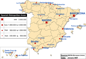 The most important metropolitan areas and their 2007 populations are:
coal
, lignite
, iron ore, uranium
, mercury
, pyrite
s, fluorspar, gypsum
, zinc
, lead
, tungsten
, copper
, kaolin, potash
, hydropower
, arable land
Land use:
Irrigated land:
34,530 km² (1993 est.)
periodic droughts, wildfires
Environment - Current Issues:
Environment - International Agreements:
Spain
Spain , officially the Kingdom of Spain languages]] under the European Charter for Regional or Minority Languages. In each of these, Spain's official name is as follows:;;;;;;), is a country and member state of the European Union located in southwestern Europe on the Iberian Peninsula...
is a constitutional monarchy
Constitutional monarchy
Constitutional monarchy is a form of government in which a monarch acts as head of state within the parameters of a constitution, whether it be a written, uncodified or blended constitution...
located in southwestern Europe
Europe
Europe is, by convention, one of the world's seven continents. Comprising the westernmost peninsula of Eurasia, Europe is generally 'divided' from Asia to its east by the watershed divides of the Ural and Caucasus Mountains, the Ural River, the Caspian and Black Seas, and the waterways connecting...
. It occupies most (about. 85 percent) of the Iberian Peninsula
Iberian Peninsula
The Iberian Peninsula , sometimes called Iberia, is located in the extreme southwest of Europe and includes the modern-day sovereign states of Spain, Portugal and Andorra, as well as the British Overseas Territory of Gibraltar...
ind includes a small exclave inside France called Llívia
Llívia
Llívia is a town of Cerdanya, province of Girona, Catalonia, Spain. It is a Spanish exclave within the French département of Pyrénées-Orientales...
as well as the Balearic Islands
Balearic Islands
The Balearic Islands are an archipelago of Spain in the western Mediterranean Sea, near the eastern coast of the Iberian Peninsula.The four largest islands are: Majorca, Minorca, Ibiza and Formentera. The archipelago forms an autonomous community and a province of Spain with Palma as the capital...
in the Mediterranean, the Canary Islands
Canary Islands
The Canary Islands , also known as the Canaries , is a Spanish archipelago located just off the northwest coast of mainland Africa, 100 km west of the border between Morocco and the Western Sahara. The Canaries are a Spanish autonomous community and an outermost region of the European Union...
in the Western Atlantic Ocean
Atlantic Ocean
The Atlantic Ocean is the second-largest of the world's oceanic divisions. With a total area of about , it covers approximately 20% of the Earth's surface and about 26% of its water surface area...
108 km (67 mi) off northwest Africa, and five places of sovereignty
Plazas de soberanía
The plazas de soberanía or sovereign territories, referred to in English as Spanish North Africa or simply Spanish Africa, are the current Spanish territories in continental North Africa bordering Morocco, except the autonomous cities of Ceuta and Melilla.After the Reconquista, forces of the...
(plazas de soberanía) on and off the coast of Morocco
Morocco
Morocco , officially the Kingdom of Morocco , is a country located in North Africa. It has a population of more than 32 million and an area of 710,850 km², and also primarily administers the disputed region of the Western Sahara...
: Ceuta
Ceuta
Ceuta is an autonomous city of Spain and an exclave located on the north coast of North Africa surrounded by Morocco. Separated from the Iberian peninsula by the Strait of Gibraltar, Ceuta lies on the border of the Mediterranean Sea and the Atlantic Ocean. Ceuta along with the other Spanish...
, Melilla
Melilla
Melilla is a autonomous city of Spain and an exclave on the north coast of Morocco. Melilla, along with the Spanish exclave Ceuta, is one of the two Spanish territories located in mainland Africa...
, Islas Chafarinas
Islas Chafarinas
The Chafarinas Islands , also spelled Zafarin, Djaferin, Zafarani, is a Spanish archipelago. A group of three small islets located in the Alboran Sea off the coast of Morocco with an aggregate area of 0.525 km², 45 km to the east of Melilla and 3.3 km off the Moroccan town of Ra'su l-Ma'...
, Peñón de Alhucemas
Peñón de Alhucemas
Peñón de Alhucemas , or "Lavender Rock", is one of the Spanish plazas de soberanía just off the Moroccan coast in the Alboran Sea. It is also one of several Peñones, or rock-fortresses, on the coast of Northern Africa....
, and Peñón de Vélez de la Gomera
Peñón de Vélez de la Gomera
Peñón de Vélez de la Gomera , in ancient times Badis or Bades, is a Spanish rock in North Africa off the Moroccan coast . It is part of several Peñones, or rock-fortresses on the coast of Northern Africa. Vélez de la Gomera is administered from Melilla...
.
The Spanish mainland is bordered to the south and east almost entirely by the Mediterranean Sea
Mediterranean Sea
The Mediterranean Sea is a sea connected to the Atlantic Ocean surrounded by the Mediterranean region and almost completely enclosed by land: on the north by Anatolia and Europe, on the south by North Africa, and on the east by the Levant...
(except for a small land boundary with Gibraltar
Gibraltar
Gibraltar is a British overseas territory located on the southern end of the Iberian Peninsula at the entrance of the Mediterranean. A peninsula with an area of , it has a northern border with Andalusia, Spain. The Rock of Gibraltar is the major landmark of the region...
); to the north by France
France
The French Republic , The French Republic , The French Republic , (commonly known as France , is a unitary semi-presidential republic in Western Europe with several overseas territories and islands located on other continents and in the Indian, Pacific, and Atlantic oceans. Metropolitan France...
, Andorra
Andorra
Andorra , officially the Principality of Andorra , also called the Principality of the Valleys of Andorra, , is a small landlocked country in southwestern Europe, located in the eastern Pyrenees mountains and bordered by Spain and France. It is the sixth smallest nation in Europe having an area of...
, and the Bay of Biscay
Bay of Biscay
The Bay of Biscay is a gulf of the northeast Atlantic Ocean located south of the Celtic Sea. It lies along the western coast of France from Brest south to the Spanish border, and the northern coast of Spain west to Cape Ortegal, and is named in English after the province of Biscay, in the Spanish...
; and to the west by the Atlantic Ocean
Atlantic Ocean
The Atlantic Ocean is the second-largest of the world's oceanic divisions. With a total area of about , it covers approximately 20% of the Earth's surface and about 26% of its water surface area...
and Portugal
Portugal
Portugal , officially the Portuguese Republic is a country situated in southwestern Europe on the Iberian Peninsula. Portugal is the westernmost country of Europe, and is bordered by the Atlantic Ocean to the West and South and by Spain to the North and East. The Atlantic archipelagos of the...
. With an area of 504,030 km², Spain is the second largest country in Western Europe
Western Europe
Western Europe is a loose term for the collection of countries in the western most region of the European continents, though this definition is context-dependent and carries cultural and political connotations. One definition describes Western Europe as a geographic entity—the region lying in the...
(behind France) and with an average altitude of 650 m, the second highest country in Europe (behind Switzerland
Switzerland
Switzerland name of one of the Swiss cantons. ; ; ; or ), in its full name the Swiss Confederation , is a federal republic consisting of 26 cantons, with Bern as the seat of the federal authorities. The country is situated in Western Europe,Or Central Europe depending on the definition....
).
Its total area is 504782 km² (194,897 sq mi) of which 499542 km² (192,874 sq mi) is land and 5240 km² (2,023 sq mi) is water. Spain lies between latitudes 26°
26th parallel north
The 26th parallel north is a circle of latitude that is 26 degrees north of the Earth's equatorial plane. It crosses Africa, Asia, the Indian Ocean, the Pacific Ocean, North America and the Atlantic Ocean....
and 44° N
44th parallel north
The 44th parallel north is a circle of latitude that is 44 degrees north of the Earth's equatorial plane. It crosses Europe, the Mediterranean Sea, Asia, the Pacific Ocean, North America, and the Atlantic Ocean....
, and longitudes 19° W
19th meridian west
The meridian 19° west of Greenwich is a line of longitude that extends from the North Pole across the Arctic Ocean, Greenland, Iceland, the Atlantic Ocean, the Southern Ocean, and Antarctica to the South Pole....
and 5° E
5th meridian east
The meridian 5° east of Greenwich is a line of longitude that extends from the North Pole across the Arctic Ocean, Europe, Africa, the Atlantic Ocean, the Southern Ocean, and Antarctica to the South Pole....
. Its Atlantic coast is 710 km (441 mi) long. The Pyrenees
Pyrenees
The Pyrenees is a range of mountains in southwest Europe that forms a natural border between France and Spain...
mountain range
Mountain range
A mountain range is a single, large mass consisting of a succession of mountains or narrowly spaced mountain ridges, with or without peaks, closely related in position, direction, formation, and age; a component part of a mountain system or of a mountain chain...
, extends 435 km (270 mi) from the Mediterranean to the Bay of Biscay. In the extreme south of Spain lie the Straits of Gibraltar, which separate Spain and the rest of Europe from Ceuta and Morocco
Morocco
Morocco , officially the Kingdom of Morocco , is a country located in North Africa. It has a population of more than 32 million and an area of 710,850 km², and also primarily administers the disputed region of the Western Sahara...
in north Africa
North Africa
North Africa or Northern Africa is the northernmost region of the African continent, linked by the Sahara to Sub-Saharan Africa. Geopolitically, the United Nations definition of Northern Africa includes eight countries or territories; Algeria, Egypt, Libya, Morocco, South Sudan, Sudan, Tunisia, and...
; at its narrowest extent, Spain and Morocco are separated by only 13 km (8.1 mi).
External boundaries and landform regions
Most of Spain's boundaries are water: the Mediterranean Sea on the south and east from Gibraltar to the French border and the Atlantic Ocean on the northwest and southwest (in the south as the Golfo de CádizGulf of Cadiz
The Gulf of Cádiz is the arm of the Atlantic Ocean between Cape St. Vincent in Portugal and Cape Trafalgar at the western end of the Strait of Gibraltar...
and in the north as the Bay of Biscay
Bay of Biscay
The Bay of Biscay is a gulf of the northeast Atlantic Ocean located south of the Celtic Sea. It lies along the western coast of France from Brest south to the Spanish border, and the northern coast of Spain west to Cape Ortegal, and is named in English after the province of Biscay, in the Spanish...
). Spain also shares land boundaries with France
France
The French Republic , The French Republic , The French Republic , (commonly known as France , is a unitary semi-presidential republic in Western Europe with several overseas territories and islands located on other continents and in the Indian, Pacific, and Atlantic oceans. Metropolitan France...
and Andorra
Andorra
Andorra , officially the Principality of Andorra , also called the Principality of the Valleys of Andorra, , is a small landlocked country in southwestern Europe, located in the eastern Pyrenees mountains and bordered by Spain and France. It is the sixth smallest nation in Europe having an area of...
along the Pyrenees
Pyrenees
The Pyrenees is a range of mountains in southwest Europe that forms a natural border between France and Spain...
in the northeast, with Portugal
Portugal
Portugal , officially the Portuguese Republic is a country situated in southwestern Europe on the Iberian Peninsula. Portugal is the westernmost country of Europe, and is bordered by the Atlantic Ocean to the West and South and by Spain to the North and East. The Atlantic archipelagos of the...
on the west, and with the small British Overseas Territory of Gibraltar
Gibraltar
Gibraltar is a British overseas territory located on the southern end of the Iberian Peninsula at the entrance of the Mediterranean. A peninsula with an area of , it has a northern border with Andalusia, Spain. The Rock of Gibraltar is the major landmark of the region...
near the southernmost tip. The affiliation of Gibraltar has continued to be a contentious issue between Spain and Britain
United Kingdom
The United Kingdom of Great Britain and Northern IrelandIn the United Kingdom and Dependencies, other languages have been officially recognised as legitimate autochthonous languages under the European Charter for Regional or Minority Languages...
and so is the sovereignty of the plazas de soberanía
Plazas de soberanía
The plazas de soberanía or sovereign territories, referred to in English as Spanish North Africa or simply Spanish Africa, are the current Spanish territories in continental North Africa bordering Morocco, except the autonomous cities of Ceuta and Melilla.After the Reconquista, forces of the...
, claimed by Morocco.
Spain also has a small exclave inside France called Llívia
Llívia
Llívia is a town of Cerdanya, province of Girona, Catalonia, Spain. It is a Spanish exclave within the French département of Pyrénées-Orientales...
.
The majority of Spain's peninsular region consists of the Meseta Central, a highland plateau rimmed and dissected by mountain ranges. Other landforms include narrow coastal plains and some lowland river valleys, the most prominent of which is the Andalusian Plain in the southwest. The country can be divided into ten natural regions or subregions: the dominant Meseta Central, the Cantabrian Mountains
Cantabrian Mountains
The Cantabrian Mountains or Cantabrian Range are one of the main systems of mountain ranges in Spain.They extend for more than approximately 180 miles across northern Spain, from the western limit of the Pyrenees to the edges of the Galician Massif close to Galicia, along the coast of the...
(Cordillera Cantabrica) and the northwest region, the Ibérico
Sistema Ibérico
The Sistema Ibérico or Iberian System is one of the main systems of mountain ranges in Spain.It is a vast and complex system of mountain chains and massifs located in the central regions of the Iberian Peninsula, but reaching almost the Mediterranean coast in the Land of Valencia in the east.From...
region, the Pyrenees, the Penibético
Baetic Cordillera
The Baetic System is the main system of mountain ranges in Spain. Located in southern and eastern Spain, it is also known as the Baetic Cordillera, Baetic Ranges or Baetic Mountains...
region in the southeast, the Andalusia
Andalusia
Andalusia is the most populous and the second largest in area of the autonomous communities of Spain. The Andalusian autonomous community is officially recognised as a nationality of Spain. The territory is divided into eight provinces: Huelva, Seville, Cádiz, Córdoba, Málaga, Jaén, Granada and...
n Plain, the Ebro
Ebro
The Ebro or Ebre is one of the most important rivers in the Iberian Peninsula. It is the biggest river by discharge volume in Spain.The Ebro flows through the following cities:*Reinosa in Cantabria.*Miranda de Ebro in Castile and León....
Basin, the coastal plains, the Balearic Islands
Balearic Islands
The Balearic Islands are an archipelago of Spain in the western Mediterranean Sea, near the eastern coast of the Iberian Peninsula.The four largest islands are: Majorca, Minorca, Ibiza and Formentera. The archipelago forms an autonomous community and a province of Spain with Palma as the capital...
, and the Canary Islands
Canary Islands
The Canary Islands , also known as the Canaries , is a Spanish archipelago located just off the northwest coast of mainland Africa, 100 km west of the border between Morocco and the Western Sahara. The Canaries are a Spanish autonomous community and an outermost region of the European Union...
. These are commonly grouped into four types: the Meseta Central and associated mountains, other mountainous regions, lowland regions, and islands.
The Inner Plateau and associated mountains
The Meseta Central ("Inner Plateau") is a vast plateau in the heart of peninsular Spain, has elevations that range from 610 to 760 m. Rimmed by mountains, the Meseta Central slopes gently to the west and to the series of rivers that form some of the border with PortugalPortugal
Portugal , officially the Portuguese Republic is a country situated in southwestern Europe on the Iberian Peninsula. Portugal is the westernmost country of Europe, and is bordered by the Atlantic Ocean to the West and South and by Spain to the North and East. The Atlantic archipelagos of the...
. The Sistema Central
Sistema Central
The Sistema Central is one of the main systems of mountain ranges in the Iberian Peninsula.-Description:The Sistema Central is a primary feature of the Meseta Central, the inner Iberian plateau, splitting the meseta into two parts...
, described as the "dorsal spine" of the Meseta Central, divides the Meseta into northern and southern subregions, the former higher in elevation and smaller in area than the latter. The Sistema Central rims the capital city of Madrid
Madrid
Madrid is the capital and largest city of Spain. The population of the city is roughly 3.3 million and the entire population of the Madrid metropolitan area is calculated to be 6.271 million. It is the third largest city in the European Union, after London and Berlin, and its metropolitan...
with peaks that rise to 2,400 m north of the city and to lower elevations south of it. West of Madrid, the Sistema Central shows its highest peak, Pico Almanzor
Pico Almanzor
Pico Almanzor is the highest mountain in central Spain. Situated in the Sierra de Gredos in the province of Ávila, Almanzor is high. It is made of granite. The mountain is also known as Pico de Almanzor and Moro Almanzor.-History:...
, of 2,592 m. The mountains of the Sistema Central, which continue westward into Portugal, display some glacial features; the highest of the peaks are snow-capped for most of the year. Despite their height, however, the mountain system does not create a major barrier between the northern and the southern portions of the Meseta Central because several passes permit road and railroad transportation to the northwest and the northeast.
The southern portion of the Meseta is further divided by twin mountain ranges, the Montes de Toledo
Montes de Toledo
The Montes de Toledo are one of the main systems of mountain ranges in Spain. They divide the drainage basin of the Tagus from the basin of the Guadiana.-Description:...
running to the east and the Sierra de Guadalupe, Spain, to the west. Their peaks do not rise much higher than 1,500 m. With many easy passes, including those that connect the Meseta with the Andalusian Plain, the Montes de Toledo and the Sierra de Guadalupe do not present an obstacle to transportation and communication. The two mountain ranges are separated from the Sistema Central to the north by the longest river in the Iberian Peninsula: the Tagus River.
Sierra Morena
The Sierra Morena is one of the main systems of mountain ranges in Spain.It stretches for 400 kilometres East-West across southern Spain, forming the southern border of the Meseta Central plateau of the Iberian Peninsula, and providing the watershed between the valleys of the Guadiana to the...
, the Cordillera Cantábrica
Cantabrian Mountains
The Cantabrian Mountains or Cantabrian Range are one of the main systems of mountain ranges in Spain.They extend for more than approximately 180 miles across northern Spain, from the western limit of the Pyrenees to the edges of the Galician Massif close to Galicia, along the coast of the...
, and the Sistema Ibérico
Sistema Ibérico
The Sistema Ibérico or Iberian System is one of the main systems of mountain ranges in Spain.It is a vast and complex system of mountain chains and massifs located in the central regions of the Iberian Peninsula, but reaching almost the Mediterranean coast in the Land of Valencia in the east.From...
. Forming the southern edge of the Meseta Central, the Sierra Morena merges in the east with the southern extension of the Sistema Iberico and reaches westward along the northern edge of the Rio Guadalquivir valley to join the mountains in southern Portugal. The massif of the Sierra Morena extends northward to the Río Guadiana
Guadiana
The Guadiana , or Odiana, is an international river located on the Portuguese–Spanish border, separating Extremadura and Andalucia from Alentejo and Algarve...
, which separates it from the Sistema Central. Despite their relatively low elevations, seldom surpassing 1,300 m, the mountains of the Sierra Morena are rugged.
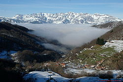
The Cordillera Cantábrica, a limestone formation, runs parallel to, and close to, the northern coast near the Bay of Biscay. Its highest points are the Picos de Europa
Picos de Europa
The Picos de Europa is a range of mountains 20 km inland from the northern coast of Spain, located in the Autonomous Communities of Asturias, Cantabria and Castile and León, forming part of the Cantabrian Mountains...
, surpassing 2,600 m. The Cordillera Cantábrica extends 182 km and abruptly drops 1,500 m some 30 km from the coast. To the west lie the hills of the northwest region and to the east the Basque mountains
Basque mountains
The Basque Mountains are a mountain range situated in the northern Iberian Peninsula. Geographically it is considered as the eastern section of the larger Cantabrian Range...
that link them to the Pyrenees.
The Sistema Ibérico extends from the Cordillera Cantábrica southeastward and, close to the Mediterranean, spreads out from the Río Ebro
Ebro
The Ebro or Ebre is one of the most important rivers in the Iberian Peninsula. It is the biggest river by discharge volume in Spain.The Ebro flows through the following cities:*Reinosa in Cantabria.*Miranda de Ebro in Castile and León....
to the Río Júcar
Júcar
The Júcar or Xúquer is a river on the Iberian Peninsula of Spain. The river runs for approximately 509 km from its source at Ojuelos de Valdeminguete, on the eastern flank of the Montes Universales, Sistema Ibérico...
. The barren, rugged slopes of this mountain range cover an area of close to 21,000 square kilometers. The mountains exceed 2,000 m in their northern region and reach a maximum height of over 2,300 m east of the headwaters of the Rio Duero. The extremely steep mountain slopes in this range are often cut by deep, narrow gorges.
Other mountainous regions
External to the Meseta Central lie the PyreneesPyrenees
The Pyrenees is a range of mountains in southwest Europe that forms a natural border between France and Spain...
in the northeast and the Sistema Penibético in the southeast. The Pyrenees, extending from the eastern edge of the Cordillera Cantábrica to the Mediterranean Sea, form a solid barrier and a natural border between Spain and both France and Andorra that, throughout history, has effectively isolated the countries from each other. Passage is easy in the relatively low terrain at the eastern and western extremes of the mountain range; it is here that international railroads and roadways cross the border. In the central section of the Pyrenees, however, passage is difficult. In several places, peaks rise above 3,000 m; the highest, Pico de Aneto
Aneto
Aneto is the highest mountain in the Pyrenees and in Aragon, and Spain's third highest mountain, reaching a height of . It lies in the Spanish province of Huesca, the northernmost of all three Aragonese provinces. It forms the southernmost part of the Maladeta massif...
, surpasses 3,400 m.
The Sistema Penibético extends northeast from the southern tip of Spain, running parallel to the coast until it merges with the southern extension of the Sistema Ibérico near the Rio Júcar and with the eastern extension of the Sierra Morena. The Sierra Nevada
Sierra Nevada (Spain)
The Sierra Nevada is a mountain range in the region of provinces of Granada and Almería in Spain. It contains the highest point of continental Spain, Mulhacén at 3478 m above sea level....
, part of the Sistema Penibético south of Granada
Granada
Granada is a city and the capital of the province of Granada, in the autonomous community of Andalusia, Spain. Granada is located at the foot of the Sierra Nevada mountains, at the confluence of three rivers, the Beiro, the Darro and the Genil. It sits at an elevation of 738 metres above sea...
, includes the highest mountain on the peninsula and continental Spain, Mulhacén
Mulhacén
Mulhacén is the highest mountain in continental Spain and in the Iberian Peninsula. It is part of the Sierra Nevada range in the Cordillera Penibética...
, which rises to 3,479 m. Other peaks in the range also surpass 3,000 m.
Lowland regions
The major lowland regions are the Andalusian Plain in the southwest, the Ebro Basin in the northeast, and the coastal plains. The Andalusian Plain is essentially a wide river valley through which the Río GuadalquivirGuadalquivir
The Guadalquivir is the fifth longest river in the Iberian peninsula and the second longest river to be its whole length in Spain. The Guadalquivir is 657 kilometers long and drains an area of about 58,000 square kilometers...
flows. The river broadens out along its course, reaching its widest point at the Golfo de Cadiz. The Andalusian Plain is bounded on the north by the Sierra Morena and on the south by the Sistema Penibético; it to an apex in the east where these two mountain chains meet. The Ebro Basin is formed by the Río Ebro valley, contained by mountains on three sides—the Sistema Ibérico to the south and west, the Pyrenees to the north and east, and their coastal extensions paralleling the shore to the east. Minor low-lying river valleys close to the Portuguese border are located on the Tagus and the Río Guadiana.
The Coastal Plains regions are narrow strips between the coastal mountains and the seas. They are broadest along the Golfo de Cádiz, where the coastal plain adjoins the Andalusian Plain, and along the southern and central eastern coasts. The narrowest coastal plain runs along the Bay of Biscay, where the Cordillera Cantábrica ends close to shore.
The islands
The remaining regions of Spain are the Balearic and the Canary IslandsCanary Islands
The Canary Islands , also known as the Canaries , is a Spanish archipelago located just off the northwest coast of mainland Africa, 100 km west of the border between Morocco and the Western Sahara. The Canaries are a Spanish autonomous community and an outermost region of the European Union...
, the former located in the Mediterranean Sea and the latter in the Atlantic Ocean. The Balearic Islands, encompassing a total area of 5,000 square kilometers, lie 80 kilometers off Spain's central eastern coast. The mountains that rise up above the Mediterranean Sea to form these islands are an extension of the Sistema Penibetico. The archipelago's highest points, which reach 1,400 meters, are in northwestern Mallorca
Mallorca
Majorca or Mallorca is an island located in the Mediterranean Sea, one of the Balearic Islands.The capital of the island, Palma, is also the capital of the autonomous community of the Balearic Islands. The Cabrera Archipelago is administratively grouped with Majorca...
, close to the coast. The central portion of Majorca is a plain, bounded on the east and the southeast by broken hills.
The Canary Islands, ninety kilometers off the west coast of Africa
Africa
Africa is the world's second largest and second most populous continent, after Asia. At about 30.2 million km² including adjacent islands, it covers 6% of the Earth's total surface area and 20.4% of the total land area...
, are of volcanic origin. The large central islands, Tenerife
Tenerife
Tenerife is the largest and most populous island of the seven Canary Islands, it is also the most populated island of Spain, with a land area of 2,034.38 km² and 906,854 inhabitants, 43% of the total population of the Canary Islands. About five million tourists visit Tenerife each year, the...
and Gran Canaria
Gran Canaria
Gran Canaria is the second most populous island of the Canary Islands, with a population of 838,397 which constitutes approximately 40% of the population of the archipelago...
, have the highest peaks. Pico de Las Nieves
Pico de Las Nieves
Pico de Las Nieves is the highest peak of the island of Gran Canaria, Canary Islands, Spain. Its height is 1,949 meters above sea level. The origin is volcanic...
, on Gran Canaria, rises to 1,949 meters, and the Teide
Teide
Mount Teide , is a volcano on Tenerife, Canary Islands. Its summit is the highest point in Spain, the highest point above sea level in the islands of the Atlantic, and it is the third highest volcano in the world measured from its base on the ocean floor, after Mauna Loa and Mauna Kea located in...
, on Tenerife, to 3,718 meters. Teide, a dormant volcano
Volcano
2. Bedrock3. Conduit 4. Base5. Sill6. Dike7. Layers of ash emitted by the volcano8. Flank| 9. Layers of lava emitted by the volcano10. Throat11. Parasitic cone12. Lava flow13. Vent14. Crater15...
, is the highest peak of Spain and the third largest volcano in the world from its base.
Drainage
Tagus
The Tagus is the longest river on the Iberian Peninsula. It is long, in Spain, along the border between Portugal and Spain and in Portugal, where it empties into the Atlantic Ocean at Lisbon. It drains an area of . The Tagus is highly utilized for most of its course...
is more than 960 kilometers long; all but 90 extend less than 96 kilometers. These shorter rivers carry small volumes of water on an irregular basis, and they have seasonally dry river beds; however, when they do flow, they often are swift and torrential. Most major rivers rise in the mountains rimming or dissecting the Meseta Central and flow westward across the plateau through Portugal
Portugal
Portugal , officially the Portuguese Republic is a country situated in southwestern Europe on the Iberian Peninsula. Portugal is the westernmost country of Europe, and is bordered by the Atlantic Ocean to the West and South and by Spain to the North and East. The Atlantic archipelagos of the...
to empty into the Atlantic Ocean
Atlantic Ocean
The Atlantic Ocean is the second-largest of the world's oceanic divisions. With a total area of about , it covers approximately 20% of the Earth's surface and about 26% of its water surface area...
. One significant exception is the river with the most abundant flow in Spain, the Ebro
Ebro
The Ebro or Ebre is one of the most important rivers in the Iberian Peninsula. It is the biggest river by discharge volume in Spain.The Ebro flows through the following cities:*Reinosa in Cantabria.*Miranda de Ebro in Castile and León....
, which flows eastward to the Mediterranean. Rivers in the extreme northwest and in the narrow northern coastal plain drain directly into the Atlantic Ocean. The northwestern coastline is also truncated by rias, waterbodies similar to fjords.
The major rivers flowing westward through the Meseta Central include the Duero, the Tagus
Tagus
The Tagus is the longest river on the Iberian Peninsula. It is long, in Spain, along the border between Portugal and Spain and in Portugal, where it empties into the Atlantic Ocean at Lisbon. It drains an area of . The Tagus is highly utilized for most of its course...
, the Guadiana
Guadiana
The Guadiana , or Odiana, is an international river located on the Portuguese–Spanish border, separating Extremadura and Andalucia from Alentejo and Algarve...
, and the Guadalquivir
Guadalquivir
The Guadalquivir is the fifth longest river in the Iberian peninsula and the second longest river to be its whole length in Spain. The Guadalquivir is 657 kilometers long and drains an area of about 58,000 square kilometers...
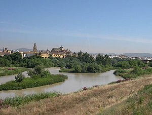
. The Rio Guadalquivir is one of the most significant rivers in Spain because it irrigates a fertile valley, thus creating a rich agricultural area, and because it is navigable inland, making Seville the only inland river port for ocean-going traffic in Spain. The major river in the northwest region is the Miño
Minho River
The Minho or Miño is the longest river in Galicia, Spain, with an extension of 340 km.Both names come from Latin Minius...
.
El Atazar Dam
El Atazar Dam
El Atazar Dam is an arch dam built near Madrid, Spain on the Lozoya River, very close to where the Lozoya joins the Jarama. It is the oldest dome dam in the world. The curved design of the dam is optimum for the narrow gorge in which it was built to retain water in the reservoir...
is a major dam built near Madrid
Madrid
Madrid is the capital and largest city of Spain. The population of the city is roughly 3.3 million and the entire population of the Madrid metropolitan area is calculated to be 6.271 million. It is the third largest city in the European Union, after London and Berlin, and its metropolitan...
to provide a water supply.
Climate
Three main climatic zones can be separated, according to geographical situation and orographicOrography
Orography is the study of the formation and relief of mountains, and can more broadly include hills, and any part of a region's elevated terrain...
conditions:
- The Mediterranean climateMediterranean climateA Mediterranean climate is the climate typical of most of the lands in the Mediterranean Basin, and is a particular variety of subtropical climate...
, characterized by dry and warm summers. According to the Köppen climate classificationKöppen climate classificationThe Köppen climate classification is one of the most widely used climate classification systems. It was first published by Crimea German climatologist Wladimir Köppen in 1884, with several later modifications by Köppen himself, notably in 1918 and 1936...
, it is dominant in the peninsula, with two varieties: Csa and Csb. - The semiarid climate (Bsh, Bsk), located in the southeastern quarter of the country, especially in the region of MurciaMurcia-History:It is widely believed that Murcia's name is derived from the Latin words of Myrtea or Murtea, meaning land of Myrtle , although it may also be a derivation of the word Murtia, which would mean Murtius Village...
and in the EbroEbroThe Ebro or Ebre is one of the most important rivers in the Iberian Peninsula. It is the biggest river by discharge volume in Spain.The Ebro flows through the following cities:*Reinosa in Cantabria.*Miranda de Ebro in Castile and León....
valley. In contrast with the Mediterranean climate, the dry season extends beyond the summer. - The oceanic climateOceanic climateAn oceanic climate, also called marine west coast climate, maritime climate, Cascadian climate and British climate for Köppen climate classification Cfb and subtropical highland for Köppen Cfb or Cwb, is a type of climate typically found along the west coasts at the middle latitudes of some of the...
(Cfb), located in north quarter of the country, especially in the region of Basque CountryBasque Country (autonomous community)The Basque Country is an autonomous community of northern Spain. It includes the Basque provinces of Álava, Biscay and Gipuzkoa, also called Historical Territories....
, AsturiasAsturiasThe Principality of Asturias is an autonomous community of the Kingdom of Spain, coextensive with the former Kingdom of Asturias in the Middle Ages...
, CantabriaCantabriaCantabria is a Spanish historical region and autonomous community with Santander as its capital city. It is bordered on the east by the Basque Autonomous Community , on the south by Castile and León , on the west by the Principality of Asturias, and on the north by the Cantabrian Sea.Cantabria...
and partly Galicia. In contrary to the Mediterranean climate, winter and summer temperatures are influenced by the ocean.
Apart from these main types, other sub-types can be found, like the alpine climate
Alpine climate
Alpine climate is the average weather for a region above the tree line. This climate is also referred to as mountain climate or highland climate....
in the Pyrenees
Pyrenees
The Pyrenees is a range of mountains in southwest Europe that forms a natural border between France and Spain...
and Sierra Nevada
Sierra Nevada (Spain)
The Sierra Nevada is a mountain range in the region of provinces of Granada and Almería in Spain. It contains the highest point of continental Spain, Mulhacén at 3478 m above sea level....
, and a typical subtropical climate in the Canary Islands.
Population geography
Largest cities by population
- MadridMadridMadrid is the capital and largest city of Spain. The population of the city is roughly 3.3 million and the entire population of the Madrid metropolitan area is calculated to be 6.271 million. It is the third largest city in the European Union, after London and Berlin, and its metropolitan...
3,228,359 - BarcelonaBarcelonaBarcelona is the second largest city in Spain after Madrid, and the capital of Catalonia, with a population of 1,621,537 within its administrative limits on a land area of...
1,582,738 - Valencia 797,654 http://www.ine.es
- SevilleSevilleSeville is the artistic, historic, cultural, and financial capital of southern Spain. It is the capital of the autonomous community of Andalusia and of the province of Seville. It is situated on the plain of the River Guadalquivir, with an average elevation of above sea level...
709,975 - ZaragozaZaragozaZaragoza , also called Saragossa in English, is the capital city of the Zaragoza Province and of the autonomous community of Aragon, Spain...
626,081 - MálagaMálagaMálaga is a city and a municipality in the Autonomous Community of Andalusia, Spain. With a population of 568,507 in 2010, it is the second most populous city of Andalusia and the sixth largest in Spain. This is the southernmost large city in Europe...
547,105 - MurciaMurcia-History:It is widely believed that Murcia's name is derived from the Latin words of Myrtea or Murtea, meaning land of Myrtle , although it may also be a derivation of the word Murtia, which would mean Murtius Village...
391,146 - Las Palmas de Gran CanariaLas Palmas de Gran CanariaLas Palmas de Gran Canaria commonly known as Las Palmas is the political capital, jointly with Santa Cruz, the most populous city in the Autonomous Community of the Canary Islands and the ninth largest city in Spain, with a population of 383,308 in 2010. Nearly half of the people of the island...
377,600 - PalmaPalma de MallorcaPalma is the major city and port on the island of Majorca and capital city of the autonomous community of the Balearic Islands in Spain. The names Ciutat de Mallorca and Ciutat were used before the War of the Spanish Succession and are still used by people in Majorca. However, the official name...
367,277 - BilbaoBilbaoBilbao ) is a Spanish municipality, capital of the province of Biscay, in the autonomous community of the Basque Country. With a population of 353,187 , it is the largest city of its autonomous community and the tenth largest in Spain...
353,567 - ValladolidValladolidValladolid is a historic city and municipality in north-central Spain, situated at the confluence of the Pisuerga and Esgueva rivers, and located within three wine-making regions: Ribera del Duero, Rueda and Cigales...
321,143 - CórdobaCórdoba, Spain-History:The first trace of human presence in the area are remains of a Neanderthal Man, dating to c. 32,000 BC. In the 8th century BC, during the ancient Tartessos period, a pre-urban settlement existed. The population gradually learned copper and silver metallurgy...
318,628 - AlicanteAlicanteAlicante or Alacant is a city in Spain, the capital of the province of Alicante and of the comarca of Alacantí, in the south of the Valencian Community. It is also a historic Mediterranean port. The population of the city of Alicante proper was 334,418, estimated , ranking as the second-largest...
305,911 - VigoVigoVigo is a city and municipality in north-west Spain, in Galicia, situated on the ria of the same name on the Atlantic Ocean.-Population:...
292,566 - GijónGijónGijón , officially Gijón / Xixón, is a coastal industrial city and a municipality in the autonomous community of Asturias in Spain. Early mediaeval texts mention it as "Gigia". It was an important regional Roman city, although the area has been settled since earliest history...
270,875 - Hospitalet de LlobregatL'Hospitalet de LlobregatL'Hospitalet de Llobregat or briefly L'Hospitalet is a city to the immediate southwest of Barcelona in Catalonia, Spain, and the second largest in Catalonia by population...
246,415 - A CoruñaA CoruñaA Coruña or La Coruña is a city and municipality of Galicia, Spain. It is the second-largest city in the autonomous community and seventeenth overall in the country...
(Corunna) 243,902 - GranadaGranadaGranada is a city and the capital of the province of Granada, in the autonomous community of Andalusia, Spain. Granada is located at the foot of the Sierra Nevada mountains, at the confluence of three rivers, the Beiro, the Darro and the Genil. It sits at an elevation of 738 metres above sea...
237,663 - Vitoria-Gasteiz 223,257
- Santa Cruz de TenerifeSanta Cruz de TenerifeSanta Cruz de Tenerife is the capital , second-most populous city of the Autonomous Community of the Canary Islands and the 21st largest city in Spain, with a population of 222,417 in 2009...
220,022 - BadalonaBadalonaBadalona is a city in eastern Catalonia, Spain. It is located in the comarca of the Barcelonès, near the city of Barcelona and part of its metropolitan area. It is situated on the left bank of the small Besòs River and on the Mediterranean Sea, backed by the Serra de la Marina mountain range...
214,440 - OviedoOviedoOviedo is the capital city of the Principality of Asturias in northern Spain. It is also the name of the municipality that contains the city....
207,699 - Elche 207,163
- MóstolesMóstolesMóstoles is the second-largest city in population belonging to the autonomous community of Madrid. It is located 18 kilometres southwest from central Madrid. Móstoles was for a long time only a small village, but expanded rapidly in the twentieth century....
201,789 - TerrassaTerrassaTerrassa is a city in the east central region of Catalonia, Spain, in the comarca of Vallès Occidental, of which it is the co-capital along with Sabadell, the historic capital....
200,000 - PamplonaPamplonaPamplona is the historial capital city of Navarre, in Spain, and of the former kingdom of Navarre.The city is famous worldwide for the San Fermín festival, from July 6 to 14, in which the running of the bulls is one of the main attractions...
198,750
Biggest metropolitan areas
- MadridMadridMadrid is the capital and largest city of Spain. The population of the city is roughly 3.3 million and the entire population of the Madrid metropolitan area is calculated to be 6.271 million. It is the third largest city in the European Union, after London and Berlin, and its metropolitan...
5,603,285 - BarcelonaBarcelonaBarcelona is the second largest city in Spain after Madrid, and the capital of Catalonia, with a population of 1,621,537 within its administrative limits on a land area of...
4,667,136 - Valencia 1,671,189
- Sevilla 1,294,081
- BilbaoBilbaoBilbao ) is a Spanish municipality, capital of the province of Biscay, in the autonomous community of the Basque Country. With a population of 353,187 , it is the largest city of its autonomous community and the tenth largest in Spain...
950,829 - MálagaMálagaMálaga is a city and a municipality in the Autonomous Community of Andalusia, Spain. With a population of 568,507 in 2010, it is the second most populous city of Andalusia and the sixth largest in Spain. This is the southernmost large city in Europe...
897,563 - AsturiasAsturiasThe Principality of Asturias is an autonomous community of the Kingdom of Spain, coextensive with the former Kingdom of Asturias in the Middle Ages...
(GijónGijónGijón , officially Gijón / Xixón, is a coastal industrial city and a municipality in the autonomous community of Asturias in Spain. Early mediaeval texts mention it as "Gigia". It was an important regional Roman city, although the area has been settled since earliest history...
-OviedoOviedoOviedo is the capital city of the Principality of Asturias in northern Spain. It is also the name of the municipality that contains the city....
) 857,079 - AlicanteAlicanteAlicante or Alacant is a city in Spain, the capital of the province of Alicante and of the comarca of Alacantí, in the south of the Valencian Community. It is also a historic Mediterranean port. The population of the city of Alicante proper was 334,418, estimated , ranking as the second-largest...
-Elche 748,565 - ZaragozaZaragozaZaragoza , also called Saragossa in English, is the capital city of the Zaragoza Province and of the autonomous community of Aragon, Spain...
731,803 - VigoVigoVigo is a city and municipality in north-west Spain, in Galicia, situated on the ria of the same name on the Atlantic Ocean.-Population:...
662,412 - Las Palmas de Gran CanariaLas Palmas de Gran CanariaLas Palmas de Gran Canaria commonly known as Las Palmas is the political capital, jointly with Santa Cruz, the most populous city in the Autonomous Community of the Canary Islands and the ninth largest city in Spain, with a population of 383,308 in 2010. Nearly half of the people of the island...
616,903 - Bahía de CádizBay of Cádiz (comarca)The Bay of Cádiz is a comarca in the province of Cádiz, Andalusia, southern Spain. It is composed of five municipalities: Cádiz, Chiclana, El Puerto de Santa María, Puerto Réal, and San Fernando.- External links:**...
(CádizCádizCadiz is a city and port in southwestern Spain. It is the capital of the homonymous province, one of eight which make up the autonomous community of Andalusia....
-Jerez de la FronteraJerez de la FronteraJerez de la Frontera is a municipality in the province of Cádiz in the autonomous community of Andalusia, in southwestern Spain, situated midway between the sea and the mountains. , the city, the largest in the province, had 208,896 inhabitants; it is the fifth largest in Andalusia...
) 615,494 - Santa Cruz de TenerifeSanta Cruz de TenerifeSanta Cruz de Tenerife is the capital , second-most populous city of the Autonomous Community of the Canary Islands and the 21st largest city in Spain, with a population of 222,417 in 2009...
573,825 - MurciaMurcia-History:It is widely believed that Murcia's name is derived from the Latin words of Myrtea or Murtea, meaning land of Myrtle , although it may also be a derivation of the word Murtia, which would mean Murtius Village...
563,272 - Palma de MallorcaPalma de MallorcaPalma is the major city and port on the island of Majorca and capital city of the autonomous community of the Balearic Islands in Spain. The names Ciutat de Mallorca and Ciutat were used before the War of the Spanish Succession and are still used by people in Majorca. However, the official name...
474,035 - GranadaGranadaGranada is a city and the capital of the province of Granada, in the autonomous community of Andalusia, Spain. Granada is located at the foot of the Sierra Nevada mountains, at the confluence of three rivers, the Beiro, the Darro and the Genil. It sits at an elevation of 738 metres above sea...
472,638 - San SebastiánSan SebastiánDonostia-San Sebastián is a city and municipality located in the north of Spain, in the coast of the Bay of Biscay and 20 km away from the French border. The city is the capital of Gipuzkoa, in the autonomous community of the Basque Country. The municipality’s population is 186,122 , and its...
402,168 - TarragonaTarragonaTarragona is a city located in the south of Catalonia on the north-east of Spain, by the Mediterranean. It is the capital of the Spanish province of the same name and the capital of the Catalan comarca Tarragonès. In the medieval and modern times it was the capital of the Vegueria of Tarragona...
406,042 - A CoruñaA CoruñaA Coruña or La Coruña is a city and municipality of Galicia, Spain. It is the second-largest city in the autonomous community and seventeenth overall in the country...
403,007 - ValladolidValladolidValladolid is a historic city and municipality in north-central Spain, situated at the confluence of the Pisuerga and Esgueva rivers, and located within three wine-making regions: Ribera del Duero, Rueda and Cigales...
400,400 - Santander - TorrelavegaSantander, CantabriaThe port city of Santander is the capital of the autonomous community and historical region of Cantabria situated on the north coast of Spain. Located east of Gijón and west of Bilbao, the city has a population of 183,446 .-History:...
391,480 - CordobaCórdoba, Spain-History:The first trace of human presence in the area are remains of a Neanderthal Man, dating to c. 32,000 BC. In the 8th century BC, during the ancient Tartessos period, a pre-urban settlement existed. The population gradually learned copper and silver metallurgy...
323,600 - PamplonaPamplonaPamplona is the historial capital city of Navarre, in Spain, and of the former kingdom of Navarre.The city is famous worldwide for the San Fermín festival, from July 6 to 14, in which the running of the bulls is one of the main attractions...
309,631
Islands
Islander population:
|
Resources and land use
Natural resources:coal
Coal
Coal is a combustible black or brownish-black sedimentary rock usually occurring in rock strata in layers or veins called coal beds or coal seams. The harder forms, such as anthracite coal, can be regarded as metamorphic rock because of later exposure to elevated temperature and pressure...
, lignite
Lignite
Lignite, often referred to as brown coal, or Rosebud coal by Northern Pacific Railroad,is a soft brown fuel with characteristics that put it somewhere between coal and peat...
, iron ore, uranium
Uranium
Uranium is a silvery-white metallic chemical element in the actinide series of the periodic table, with atomic number 92. It is assigned the chemical symbol U. A uranium atom has 92 protons and 92 electrons, of which 6 are valence electrons...
, mercury
Mercury (element)
Mercury is a chemical element with the symbol Hg and atomic number 80. It is also known as quicksilver or hydrargyrum...
, pyrite
Pyrite
The mineral pyrite, or iron pyrite, is an iron sulfide with the formula FeS2. This mineral's metallic luster and pale-to-normal, brass-yellow hue have earned it the nickname fool's gold because of its resemblance to gold...
s, fluorspar, gypsum
Gypsum
Gypsum is a very soft sulfate mineral composed of calcium sulfate dihydrate, with the chemical formula CaSO4·2H2O. It is found in alabaster, a decorative stone used in Ancient Egypt. It is the second softest mineral on the Mohs Hardness Scale...
, zinc
Zinc
Zinc , or spelter , is a metallic chemical element; it has the symbol Zn and atomic number 30. It is the first element in group 12 of the periodic table. Zinc is, in some respects, chemically similar to magnesium, because its ion is of similar size and its only common oxidation state is +2...
, lead
Lead
Lead is a main-group element in the carbon group with the symbol Pb and atomic number 82. Lead is a soft, malleable poor metal. It is also counted as one of the heavy metals. Metallic lead has a bluish-white color after being freshly cut, but it soon tarnishes to a dull grayish color when exposed...
, tungsten
Tungsten
Tungsten , also known as wolfram , is a chemical element with the chemical symbol W and atomic number 74.A hard, rare metal under standard conditions when uncombined, tungsten is found naturally on Earth only in chemical compounds. It was identified as a new element in 1781, and first isolated as...
, copper
Copper
Copper is a chemical element with the symbol Cu and atomic number 29. It is a ductile metal with very high thermal and electrical conductivity. Pure copper is soft and malleable; an exposed surface has a reddish-orange tarnish...
, kaolin, potash
Potash
Potash is the common name for various mined and manufactured salts that contain potassium in water-soluble form. In some rare cases, potash can be formed with traces of organic materials such as plant remains, and this was the major historical source for it before the industrial era...
, hydropower
Hydropower
Hydropower, hydraulic power, hydrokinetic power or water power is power that is derived from the force or energy of falling water, which may be harnessed for useful purposes. Since ancient times, hydropower has been used for irrigation and the operation of various mechanical devices, such as...
, arable land
Land use:
- Arable land: 30%
- Permanent crops: 9%
- Permanent pastures: 21%
- Forests and woodland: 32%
- Other: 8% (1993 est.)
Irrigated land:
34,530 km² (1993 est.)
Environmental concerns
Natural hazards:periodic droughts, wildfires
Environment - Current Issues:
- pollution of the Mediterranean Sea from raw sewage and effluents from the offshore production of oil and gas
- water quality and quantity nationwide
- air pollution
- deforestation
- desertification
Environment - International Agreements:
- Party to: Air Pollution, Air Pollution-Nitrogen Oxides, Air Pollution-Sulphur 94, Air Pollution-Volatile Organic Compounds, Antarctic-Environmental Protocol, Antarctic Treaty, Biodiversity, Climate Change, Endangered Species, Environmental Modification, Hazardous Wastes, Law of the Sea, Marine Dumping, Marine Life Conservation, Nuclear Test Ban, Ozone Layer Protection, Ship Pollution, Tropical Timber 83, Tropical Timber 94, Wetlands, Whaling
- Signed, but not ratified: Air Pollution-Persistent Organic Pollutants, Climate Change-Kyoto Protocol, Desertification
Maritime claims
- contiguous zone: 24 nmi (44.4 km; 27.6 mi)
- exclusive economic zone: 200 nmi (370.4 km; 230.2 mi) (applies only to the Atlantic Ocean)
- territorial sea: 12 nmi (22.2 km; 13.8 mi)
See also
- Autonomous communities of SpainAutonomous communities of SpainAn autonomous community In other languages of Spain:*Catalan/Valencian .*Galician .*Basque . The second article of the constitution recognizes the rights of "nationalities and regions" to self-government and declares the "indissoluble unity of the Spanish nation".Political power in Spain is...
- Comarcas of SpainComarcas of SpainIn Spain traditionally and historically, some autonomous communities are also divided into comarcas .In other languages of Spain:*Catalan/Valencian , sing comarca.*Galician , sing. comarca....
- Extreme points of SpainExtreme points of SpainThis is a list of the extreme points of Spain — the points that are farther north, south, east or west than any other location.-Spain:* Northernmost Point — Punta de Estaca de Bares, Galicia at...
- Provinces of SpainProvinces of SpainSpain and its autonomous communities are divided into fifty provinces .In other languages of Spain:*Catalan/Valencian , sing. província.*Galician , sing. provincia.*Basque |Galicia]] — are not also the capitals of provinces...
External links
- Data Spain: Satellite relief maps, aerial photography, outline maps, travel maps and useful themed maps of Spain
- Virtual Cadastral: Lookup official Spanish property (catastro) deeds and other Spanish property information: exact map location, altitude, land area, and distances.