
Fraser Island, Queensland
Encyclopedia
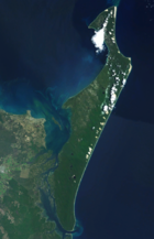
Fraser Island is an island located along the southern coast of Queensland
, Australia
, approximately 200 kilometres (124.3 mi) north of Brisbane
. Its length is about 120 kilometres (74.6 mi) and its width is approximately 24 kilometres (14.9 mi). It was inscribed as a World Heritage site in 1992. The island is considered to be the largest sand island
in the world at 1840 km². It is also Queensland's largest island, Australia's sixth largest island and the largest island on the East Coast of Australia
.
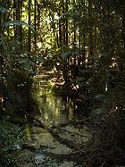
The island has rainforests, eucalyptus woodland, mangrove forests, wallum and peat swamps, sand dunes and coastal heaths. It is made up of sand that has been accumulating for approximately 750,000 years on volcanic bedrock that provides a natural catchment for the sediment which is carried on a strong offshore current northwards along the coast. Unlike many sand dunes, plant life is abundant due to the naturally occurring mycorrhiza
l fungi present in the sand, which release nutrients in a form that can be absorbed by the plants. Fraser Island is home to a small number of mammal species, as well as a diverse range of birds, reptiles and amphibians, including the occasional saltwater crocodile. The island is part of the Fraser Coast Region and protected in the Great Sandy National Park
.
Fraser Island has been inhabited by humans for as much as 5,000 years. Explorer James Cook
sailed by the island in May 1770. Matthew Flinders
landed near the most northern point of the island in 1802. For a short period the island was known as Great Sandy Island. The island became known as Fraser due to the stories of a shipwreck survivor named Eliza Fraser. Today the island is a popular tourism destination. Its resident human population was 360 at the census of 2006.
 Fraser Island is separated from the mainland by Great Sandy Strait
. The southern tip, near Tin Can Bay, is situated to the north of Inskip Peninsula
. The most northern point of the island is Sandy Cape
where the Sandy Cape Light
operated from 1870 to 1994. The establishment of the lighthouse was the first permanent European settlement on the island. The bay on the north east coast is called Marloo Bay and on the north west coast is Platypus Bay. The most westerly place on the island is Moon Point.
Eli Creek is the largest creek
on the east coast of the island with a flow of 80 million litres per day. Eli Creek has its own unique and varied wild life. Coongul Creek on the west coast has a flow rate of four to five million litres per hour. Some of the swamps on the island are fen
s, particularly near Moon Point. This was only discovered in 1996 when a group of experts who had attended a Ramsar
conference in Brisbane flew over the island and conducted an aerial survey. From above they noticed the distinct patterns of potholed peat which are devoid of trees. This was the first instance of fens found in Australia and in a sub-tropical region, although more were subsequently found on the adjacent Cooloola coast.
, Hunter and Clarence River
catchments in New South Wales
has been transported north by longshore transport. Along the eastern coast of the island the process is removing more sand than it is depositing, resulting in the slow erosion
of beaches which may accelerate with sea level rises attributed to climate change
. The sand consists of 98% quartz
.
All hills on the island have been formed by sandblowing. Sandblows are parabolic dunes which move across the island via the wind and are devoid of vegetation. In 2004, there was an estimated total of 36 sandblows on the island. With year-round south-easterly wind, the sand dunes on the island move at the rate of 1 to 2 meters a year and grow to a height of 244 meters. The dune movement creates overlapping dunes and sometimes intersect waterways and covers forests. Dune-building has occurred in episodes as the sea levels have changed and once extended much further to the east. The oldest dune system has been dated at 700,000 years, which is the world's oldest recorded sequence.
The coloured sands found at Rainbow Gorge, The Cathedrals, The Pinnacles and Red Canyon are examples of where the sand has been stained over thousands of years due to the sand conglomerating with clay
. Hematite
, the mineral pigment responsible for the staining acts like cement. This allow the steeper cliffs of coloured sand to form. Coffee rock
, so-called because when it is dissolved in water it turns the colour of coffee, is found in outcrops along the beaches on both sides of the island.
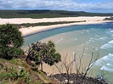
The 120 kilometres (74.6 mi) beach runs along most of the east coast of Fraser Island. It is used as a landing strip for planes and an informal highway for vehicles (highway rules state that vehicles must give way to aircraft if they are oncoming). Along the beach are the Champagne Pools, Indian Head, the Maheno Wreck and the outflow of Eli Creek. Exposed volcanic rocks are found at Indian Head, Waddy Point and Middle Rocks as well as near Boon Boon Creek.
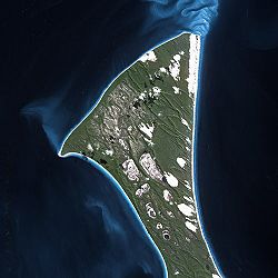
 Fraser Island has over 100 freshwater
lakes, as well as the second highest concentration of lakes in Australia after Tasmania
. The freshwater lake
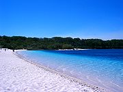
s on Fraser Island are some of the cleanest lakes in the world. A popular tourist area is Lake McKenzie
which is located inland from the small town of Eurong. It is a perched lake sitting on top of compact sand and vegetable
matter 100 metres (328.1 ft) above sea level. Lake McKenzie has an area of 150 hectares and is just over 5 metres (16.4 ft) in depth. The beach sand of Lake McKenzie is nearly pure silica. The lakes have very few nutrients and pH
varies, though sunscreen
and soap
s are a problem as a form of pollution
. Freshwater on the island may become stained by organic acid
s found in decaying vegetation. Because of the organic acids a pH
level of 3.7 has been measured in some of the island's perched lakes. The high acidity levels prevent many species from finding habitat in the lakes.
Another perched lake on the island is Lake Boomanjin, which at 200 hectares in size, is the largest perched lake in the world. In total there are 40 perched lakes on the island, half of all known lakes of this kind on the planet. Lake Boomanjin is feed by two creeks that pass through a wallum swamp where it collects tannins which tint the water red. Lake Wabby is the deepest lake on the island, at 12 metres (39.4 ft) in depth and also the least acidic which means it has the most aquatic life of all the lakes.
Some of the lakes on Fraser Island are window lakes. These form when the water table
has risen to a point higher than the surrounding land. Most of the valleys on the islands have creeks which are fed by spring
s. Motor boats and jet skis are banned from the island's lakes.
, echidnas, ringtail and brushtail possum
s, sugar gliders
, squirrel glider
s, phascogales
, bandicoots
, potoroo
s, flying foxes and dingoes. The Swamp Wallaby finds protection from dingos in the swampy areas which have dense undergrowth. There are 19 species of bats which live on or visit Fraser Island.
Until 2003, when they were removed by the Environmental Protection Agency, there were a few brumbies
(horses) on the island, descendants of Arab stock turned loose for breeding purposes, and joined in 1879 by horses brought over for the logging industry.
 Dingo
Dingo
es were once common on the island, but are now decreasing. The Fraser Island dingoes are reputedly some of the last remaining pure dingoes in Eastern Australia and to prevent cross-breeding, dogs are not allowed on the island. According to DNA-examinations from the year 2004, the dingoes on Fraser Island are "pure". However, skull measurements from the 1990s detected crossbreeds between dingoes and domestic dogs among the population.
Up until 1995, there were no official records of dingoes attacking humans on Fraser Island. In April 2001, a boy wandered away from his family and was discovered dead, with indications of a dingo mauling. Over 120 dingoes were killed by rangers as a result of the incident, though locals believe the number was much greater. After the 2001 attack, four dedicated rangers were allocated dingo management roles and ranger patrols were increased. There are fines for feeding dingoes or leaving food and rubbish out which may attract them.
As of January 2008, the number of dingoes on the island was estimated to be 120 to 150, and sightings have become less common. A University of Queensland
researcher, Nick Baker, claims the dingoes on Fraser Island have adopted unusual behaviour. Rather than hunt in small packs, Fraser Island dingoes had developed a tolerance for each other and work together in one big hunting pack. Dingo-proof fences, consisting of metals bars across a concrete pit and a 1.8 m high mesh fence were built around nine island settlements in 2008, to keep the dingos out of the townships.
In late 2009, a former ranger on the island, Ray Revill, claimed 70% of the dingo population, which was then estimated at between 100 and 120 animals, was malnourished. In March 2010, three separate reports of dingos biting tourists were made. Backpackers have been criticised for ignoring advice from park rangers as they try to provoke reactions from dingoes while taking photographs.
s, snakes, geckos
, skinks and frogs are all present on the island. Some frog species have evolved to cope with the acidic waters of lakes and swamps on the island, and are appropriately called acid frogs. The island is home to the recently discovered Fraser Island sand skink
. Freshwater turtles such as Kreffts river turtle are found in the island's lakes and creeks.
Saltwater crocodile
s are exclusively tropical reptiles and usually found in Far North Queensland
(several hundred kilometres north-west of Fraser Island,) however, occasionally during the warmer season (December through March, when water temperatures reach consistent tropical temperatures) crocodiles may appear in areas in and around Fraser Island. This is very rare, but during the 2008-2009 summer season at least four crocodiles (one over 4 metres in length) were present. It is thought that these reptiles are seasonal visitors, as they always disappear during the cold months (presumably returning to tropical northern Queensland.) This sort of activity was apparently reported but unverified decades ago (a handful of crocodiles have also historically been observed on very rare occurrences around Brisbane
, the Gold Coast
and Sunshine Coast
s during the warmer season) but within recent years has been proven and observed more often. Crocodiles do not breed nor do they appear to have any permanent populations living on Fraser Island.
 Fraser Island forms part of the Cooloola and Fraser Coast Important Bird Area
(IBA). There are over 350 different species of birds on the island. Birds of prey include sea eagles
, peregrine falcon
, osprey
and kites
. Other common birds include pelicans, terns, honeyeaters, gulls, kingfishers, kookaburra
, owl
s, dove
s, thornbills, duck
s, brolga
s, and cockatoos. The island is visited by 20 species of migratory wader birds from as far afield as Siberia. There are 22 different species of gulls and terns, four species of falcons and six species of kingfishers. A rare, bird on the island is the Eastern Ground Parrot, already extinct in some parts of Australia.
s and some species of dolphin
s are frequent visitors to the area. Dugong
s and tiger Sharks can also be found in surrounding waters. Mud crabs
are found on the western side of the island near mangrove-lined estuaries. 24 freshwater fish species are found in the island's lakes.
There has been 300 species of ants recorded on Fraser Island. Long finned eels and giant earthworms are also found on the island.
grows in sand. The island contains the largest extent of wallum heath
remnants in Queensland. In Pile Valley, 1,000 year old rough-barked satinays
are found. Despite being logged the kauri pines
dominate in some areas. Scribbly gums, red gums, piccabeen palms, Blue Quandong
, brush box
and pandanus
all grow on Fraser Island. Along the coast, the foredunes are dominated by salt-tolerant species
which includes pigface
, goats foot vine
and beach spinifix
. Spinifix sericeus is an important foundation species. Decayed matter from this dune grass breaks down in the sand, providing vital nutrients for other plant species, such as the Beach Oak
. The rare Angiopteris evecta
, a species of fern that has the largest fronds in the world, grows on Fraser Island. The southwest coast is dominated by mangroves.
As one travels from east to west across the island, the dune age increases. These leads to the progressive maturing of vegetation in the same direction, except for some areas along the western coast where soil leaching has decreased the nutrient soil layer to a depth beyond the reach of plant roots. Each lake on Fraser Island is surrounded by concentric vegetation zones. Typically these zones range from rushes in the shallows, then a mix of pioneer species on the beaches, through to sedges, heath, paperbarks, shrubs and finally eucalypt or banksia woodlands.
 Fraser Island is part of the Local Government Area Fraser Coast Region, which was created in March 2008 as a result of the report of the Local Government Reform Commission released in July 2007. Before the local government reorganization, the island was split up evenly between the City of Hervey Bay
(northern part) and the City of Maryborough
(southern part).
Fraser Island South is Local Area 8 of the City of Maryborough, and includes the existing village community of Eurong, the Kingfisher Bay Resort, and Dilli Village.
In 1971, the northern half of the island was declared a national park. Now almost all of Fraser Island is included in the Great Sandy National Park
, which is administered by Queensland's Environmental Protection Agency
. This was extended in 1992 when heritage listing was granted. Except for a few small urban areas the island is protected by a Wild Rivers declaration.
Domestic dogs are not permitted on the island and fines can be given for non-compliance. The ban, first applied in 1981, is imposed so that the island's dingo population is not exposed to diseases.
In 2010, the management of the park, particularly the treatment of dingos by the Department of Environment and Resource Management was called into question by Glen Elmes
in the Queensland Parliament
. Camp grounds are sometimes closed so as to reduce human contact with dingo populations.
people's language . It means paradise
.
The name Fraser Island comes from Eliza Fraser
and her story of survival from a shipwreck on the island. Captain James Fraser and his wife, Eliza Fraser, were shipwrecked on the island in 1836. Their ship, the Stirling Castle
, set sail from Sydney to Singapore with 18 crew and passengers. The ship was holed on coral while traveling through the Great Barrier Reef
north of the island. Transferring to two lifeboats, the crew set a course south, attempting to reach the settlement at Moreton (now Brisbane
). During this trip in the lifeboats, Captain Fraser's pregnant wife gave birth in the leaking lifeboat. The infant died soon after birth. The Captain's lifeboat was becoming more and more unseaworthy and was soon left behind by the other lifeboat which continued on. The sinking boat and its crew was beached on what was then known as the Great Sandy Island. Whether the survivors died due to disease, hunger, exhaustion or battles with the native population will never be known for sure; most likely a little of all of the above. Captain Fraser died leaving Eliza living among the local peoples. She was rescued 6 weeks after being shipwrecked by a convict, John Graham, who had lived in the bush as an escapee, and who spoke the Aboriginal language. He was sent from the settlement at Moreton by the authorities there who had heard about Eliza' plight, and negotiated her return. Within 6 months, Eliza had married another sea captain. She moved to England and became a sideshow attraction in Hyde Park telling ever more lurid tales about her experiences with white slavery, cannibalism, torture and murder. As she is known to have told several versions of the story, it is unknown which version is the most accurate.
She was killed in a carriage accident in Melbourne in 1858 during a visit.
occupied Fraser Island at least 5000 years ago. There was a permanent population of 400-600 that grew to 2000-3000 in the winter months due to abundant seafood resources. The arrival of European settlers in the area was an overwhelming disaster for the Butchulla people. European settlement in the 1840s overwhelmed the Aboriginal lifestyle with weapons, disease and lack of food. By the year 1890, Aboriginal numbers had been reduced to only 300 people. Most of the remaining Aborigines, the Butchulla tribe, left the island in 1904 as they were relocated to missions
in Yarrabah
and Durundur, Queensland. It is estimated that up to 500 indigenous archaeological sites are located on the island.
who passed along the coast of the island between 18 and 20 May 1770. He named Indian Head after viewing a number of Aboriginal people gathered on the headland. Matthew Flinders
sailed past the island in 1799, and again in 1802, this time landing at Sandy Cape, while charting Hervey Bay. His 1814 chart is a combination of both voyages, but did not confirm Fraser Island as being separate from the mainland
. However, Flinders did suggest the presence of shallow swampy areas at the lower part of the bay. Flinders was told of an opening at Hook Point, between Fraser Island and the mainland, by two American whalers who were hunting whales in Hervey Bay. In 1842, Andrew Petrie
discovered good pastoral lands and forests, attracting graziers to the island. Lieutenant Robert Dayman was the first European to sail between Fraser Island and the mainland in 1847.
) and kauri pines (Agathis robusta
) on Fraser Island were logged extensively as they provided excellent timber. Logging started in 1863, initiated by American Jack Piggott (known as 'Yankee Jack'). For the first 70 years of logging, bullock drays were used to haul the timber to loading points on the beach. Railway tracks were laid through the forest to facilitate logging, but were later removed. Some of the largest logs were sent to Egypt for the construction of the Suez Canal
. The logging industry continued right through until 1991, and ceased following the concerns of the Fraser Island Fitzgerald Inquiry, led by the Honourable Justice Gerald Edward Fitzgerald
.
, ilmenite
, zircon
and monazite
. Sand mining leases were first granted in 1950, and mining continued until 1977. Without public knowledge the Queensland Government granted mining leases to the American mining company Dillgham-Murphyores in the 1960s. In 1971, the Fraser Island Defense Organisation (FIDO) opposed the granting of more leases to the company. Despite more than 1,300 submissions that were made to the local mining warden objecting to new leases, the submission was granted. FIDO took the case to the High Court of Australia
which over-ruled the decision noting that the public interest was not being upheld. Dillgham-Murphyores continued mining. The Whitlam Government
established Australia's first environmental impact inquiry which recommended that mining cease. Eventually Malcolm Fraser
canceled the company's mineral export license which halted mining on the island. This represented a significant win for the conservation movement in Australia
. Fraser Island then became the first place to be included in the Australian Heritage Commission
's Register of the National Estate
.
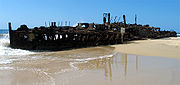
. The S.S. Maheno was originally built in 1905 in Scotland
as a luxury passenger ship for trans-Tasman crossings
. During the First World War the ship served as a hospital ship
in the English Channel
, before returning to a luxury liner. In 1935, the ship was declared outdated and on 25 June 1935 the ship was being towed from Melbourne
when it was caught in a strong cyclone
. A few days later, on 9 July 1935 she drifted ashore and was beached on Fraser Island. During the Second World War the Maheno served as target bombing practice for the RAAF and was used as an explosives demolition target by special forces from the Fraser Commando School
. The ship has since become severely rusted, with almost three and a half storeys buried under the sand. Climbing on the shipwreck is not permitted.
 During World War Two, the area near McKenzie's Jetty was used by the Services Reconnaissance Department
(popularly known as "Z Special Unit
") as a special forces training camp - the Fraser Commando School
. Thousands of soldiers were trained here because the conditions were similar to those found on Pacific Islands where the Japanese were fought. Lake McKenzie was used for parachute training and the wreck of the Maheno was used for explosive demolitions practice.
Visitors to the site of the Fraser Commando School today can still see various relics of its military past including armour plates used to test armour piercing explosive charges and weapons and a concrete relief map of Singapore Harbour used as an aid in operations planning.
on the Conditions in the Trust Territories
, the Republic of Nauru expressed concern that its phosphate mining exportation
would be depleted by the end of the century, endangering the future of the island. In 1961, Fraser Island was proposed by Australia as a location for the resettlement of the entire population of the Republic of Nauru
. The timber industry on Fraser Island managed to ensure that resettlement on Fraser Island did not proceed. In 1964 in the 31st session of United Nations Trusteeship Council meetings it was concluded that Curtis Island
could provide a more satisfactory resettlement for the population of Nauru. Nauru rejected the offer of moving the entire population to Curtis Island due to political independence considerations that Australia would not agree to. Although a resettlement never did occur, the Republic of Nauru went on to achieve independence on 31 January 1968.
Urinating tourists have created environmental issues at Fraser Island lakes and coastal dunes. The foredunes are used as a toilet by bush campers which are estimated to number 90,000 each year. Many of the perched lakes have no outflow or inflow which exacerbates the problem. Water quality
in some lakes is being impacted by storm water run-off from dune roads and swimmer's use of sunscreen.
In April 2009, a vehicle overturned on the beach after being hit by a wave. Two backpackers were killed in the accident. Following the incident speed limits were reduced from 100 km/h to 80 km/h on the beach, and from 40 km/h to 30 km/h inland. Everyone who hires a vehicle on the island from a Fraser Coast 4WD Operators Association accredited organisation must attend a one hour long briefing on vehicle safety.
Central Station is a popular tourism destination on the island. Some of the rarest ferns grow along the rainforest near the station.
from Urangan Boat Harbour (Hervey Bay) to Moon Point, River Heads (South of Hervey Bay) to Kingfisher Bay and Wanggoolba Creek
or Inskip Point to north of Rainbow Beach
to Hook Point
, or by chartered flight via Maroochydore Airport.
A four-wheel drive
is required for all landings (except Kingfisher Bay), and travel on the island (except within the Kingfisher Bay resort. A permit is required for vehicles and is obtainable on line from DERM and several outlets at Rainbow Beach. Several firms provide four-wheel drive
vehicles for rent.
Tour bus
es travel the island as well.
is one of the more common species sought by anglers on Fraser Island and along the Queensland coast. Other fish caught on the eastern coast include jewfish
, golden trevally
and surf bream, while whiting, flathead
and surf bream prefer the calmer western waters. Pilchards, bloodworms, yabbies, pipi
and sandworm
s can all be used for bait. Fishing is banned in the island's creeks and lakes.
. A shorter hike would be for example to start in Kingfisher Bay (ferry drop off) and head to Lake McKenzie, stay there for one night, and then hike back. In October 2006, Belgian adventurer Louis-Philippe Loncke
traversed the island unresupplied.
Queensland
Queensland is a state of Australia, occupying the north-eastern section of the mainland continent. It is bordered by the Northern Territory, South Australia and New South Wales to the west, south-west and south respectively. To the east, Queensland is bordered by the Coral Sea and Pacific Ocean...
, Australia
Australia
Australia , officially the Commonwealth of Australia, is a country in the Southern Hemisphere comprising the mainland of the Australian continent, the island of Tasmania, and numerous smaller islands in the Indian and Pacific Oceans. It is the world's sixth-largest country by total area...
, approximately 200 kilometres (124.3 mi) north of Brisbane
Brisbane
Brisbane is the capital and most populous city in the Australian state of Queensland and the third most populous city in Australia. Brisbane's metropolitan area has a population of over 2 million, and the South East Queensland urban conurbation, centred around Brisbane, encompasses a population of...
. Its length is about 120 kilometres (74.6 mi) and its width is approximately 24 kilometres (14.9 mi). It was inscribed as a World Heritage site in 1992. The island is considered to be the largest sand island
Sand island
A sand island is an island that is largely or completely made of sand. The largest sand island in the world is Fraser Island. Other examples of large sand islands are Moreton and North Stradbroke Islands which lie south of Fraser Island off the east coast of Australia....
in the world at 1840 km². It is also Queensland's largest island, Australia's sixth largest island and the largest island on the East Coast of Australia
Eastern states of Australia
In Australia, the term eastern states refers to the states adjoining the east coast of Australia. These are the mainland states of New South Wales, Queensland and Victoria. The Australian Capital Territory and Jervis Bay Territory, while not states, are also included. The term usually includes the...
.
The island has rainforests, eucalyptus woodland, mangrove forests, wallum and peat swamps, sand dunes and coastal heaths. It is made up of sand that has been accumulating for approximately 750,000 years on volcanic bedrock that provides a natural catchment for the sediment which is carried on a strong offshore current northwards along the coast. Unlike many sand dunes, plant life is abundant due to the naturally occurring mycorrhiza
Mycorrhiza
A mycorrhiza is a symbiotic association between a fungus and the roots of a vascular plant....
l fungi present in the sand, which release nutrients in a form that can be absorbed by the plants. Fraser Island is home to a small number of mammal species, as well as a diverse range of birds, reptiles and amphibians, including the occasional saltwater crocodile. The island is part of the Fraser Coast Region and protected in the Great Sandy National Park
Great Sandy National Park
Great Sandy is a coastal national park and suburb in Queensland, Australia. The park features untouched beaches, large sand dunes, heathlands, rainforests, swamps, creeks, freshwater lakes and mangrove forests....
.
Fraser Island has been inhabited by humans for as much as 5,000 years. Explorer James Cook
James Cook
Captain James Cook, FRS, RN was a British explorer, navigator and cartographer who ultimately rose to the rank of captain in the Royal Navy...
sailed by the island in May 1770. Matthew Flinders
Matthew Flinders
Captain Matthew Flinders RN was one of the most successful navigators and cartographers of his age. In a career that spanned just over twenty years, he sailed with Captain William Bligh, circumnavigated Australia and encouraged the use of that name for the continent, which had previously been...
landed near the most northern point of the island in 1802. For a short period the island was known as Great Sandy Island. The island became known as Fraser due to the stories of a shipwreck survivor named Eliza Fraser. Today the island is a popular tourism destination. Its resident human population was 360 at the census of 2006.
Geography and ecology
Great Sandy Strait
The Great Sandy Strait is an 70 km Australian sand passage estuary separating mainland Queensland, from World Heritage listed Fraser Island.-Description:...
. The southern tip, near Tin Can Bay, is situated to the north of Inskip Peninsula
Inskip Peninsula
Inskip Point is a peninsula to the north of the town of Rainbow Beach in south-east Queensland, Australia.It lies between Tin Can Bay to the South West and Great Sandy Strait to the North and curves back towards Rainbow Beach and the Coral Sea to the East....
. The most northern point of the island is Sandy Cape
Sandy Cape
Sandy Cape is the most northern point on Fraser Island off the coast of Queensland, Australia. The place was named by James Cook during his 1770 voyage up the eastern coast of Australia aboard the Endeavour...
where the Sandy Cape Light
Sandy Cape Light
Sandy Cape Light is an active lighthouse located on Sandy Cape, the most northern point on Fraser Island, Queensland, Australia. It stands about southwest of the northeastern tip of the island. It is the tallest lighthouse in Queensland. Built in 1870, it is the second major lighthouse to be built...
operated from 1870 to 1994. The establishment of the lighthouse was the first permanent European settlement on the island. The bay on the north east coast is called Marloo Bay and on the north west coast is Platypus Bay. The most westerly place on the island is Moon Point.
Eli Creek is the largest creek
Creek (tidal)
A tidal creek, tidal channel, or estuary is the portion of a stream that is affected by ebb and flow of ocean tides, in the case that the subject stream discharges to an ocean, sea or strait. Thus this portion of the stream has variable salinity and electrical conductivity over the tidal cycle...
on the east coast of the island with a flow of 80 million litres per day. Eli Creek has its own unique and varied wild life. Coongul Creek on the west coast has a flow rate of four to five million litres per hour. Some of the swamps on the island are fen
Fen
A fen is a type of wetland fed by mineral-rich surface water or groundwater. Fens are characterised by their water chemistry, which is neutral or alkaline, with relatively high dissolved mineral levels but few other plant nutrients...
s, particularly near Moon Point. This was only discovered in 1996 when a group of experts who had attended a Ramsar
Ramsar
Ramsar is a city in and the capital of Ramsar County, Mazandaran Province, Iran. At the 2006 census, its population was 31,659, in 9,421 families....
conference in Brisbane flew over the island and conducted an aerial survey. From above they noticed the distinct patterns of potholed peat which are devoid of trees. This was the first instance of fens found in Australia and in a sub-tropical region, although more were subsequently found on the adjacent Cooloola coast.
Sandmass
The total volume of sand above sea level on Fraser Island is 113 km³. All of the sand, which originated in the HawkesburyHawkesbury River
The Hawkesbury River, also known as Deerubbun, is one of the major rivers of the coastal region of New South Wales, Australia. The Hawkesbury River and its tributaries virtually encircle the metropolitan region of Sydney.-Geography:-Course:...
, Hunter and Clarence River
Clarence River (New South Wales)
The Clarence River is situated in northeastern New South Wales, Australia. The river originates on the watershed that marks the Queensland border. After flowing south and northeast for 394 km it then empties into the Pacific Ocean at Iluka/Yamba. On its journey it passes through the towns of...
catchments in New South Wales
New South Wales
New South Wales is a state of :Australia, located in the east of the country. It is bordered by Queensland, Victoria and South Australia to the north, south and west respectively. To the east, the state is bordered by the Tasman Sea, which forms part of the Pacific Ocean. New South Wales...
has been transported north by longshore transport. Along the eastern coast of the island the process is removing more sand than it is depositing, resulting in the slow erosion
Coastal erosion
Coastal erosion is the wearing away of land and the removal of beach or dune sediments by wave action, tidal currents, wave currents, or drainage...
of beaches which may accelerate with sea level rises attributed to climate change
Climate change in Australia
Climate change has become a major issue in Australia due to drastic climate events since the turn of the 21st century that have focused government and public attention. Rainfall in Australia has increased slightly over the past century, although there is little or no trend in rainfall in northeast...
. The sand consists of 98% quartz
Quartz
Quartz is the second-most-abundant mineral in the Earth's continental crust, after feldspar. It is made up of a continuous framework of SiO4 silicon–oxygen tetrahedra, with each oxygen being shared between two tetrahedra, giving an overall formula SiO2. There are many different varieties of quartz,...
.
All hills on the island have been formed by sandblowing. Sandblows are parabolic dunes which move across the island via the wind and are devoid of vegetation. In 2004, there was an estimated total of 36 sandblows on the island. With year-round south-easterly wind, the sand dunes on the island move at the rate of 1 to 2 meters a year and grow to a height of 244 meters. The dune movement creates overlapping dunes and sometimes intersect waterways and covers forests. Dune-building has occurred in episodes as the sea levels have changed and once extended much further to the east. The oldest dune system has been dated at 700,000 years, which is the world's oldest recorded sequence.
The coloured sands found at Rainbow Gorge, The Cathedrals, The Pinnacles and Red Canyon are examples of where the sand has been stained over thousands of years due to the sand conglomerating with clay
Clay
Clay is a general term including many combinations of one or more clay minerals with traces of metal oxides and organic matter. Geologic clay deposits are mostly composed of phyllosilicate minerals containing variable amounts of water trapped in the mineral structure.- Formation :Clay minerals...
. Hematite
Hematite
Hematite, also spelled as haematite, is the mineral form of iron oxide , one of several iron oxides. Hematite crystallizes in the rhombohedral system, and it has the same crystal structure as ilmenite and corundum...
, the mineral pigment responsible for the staining acts like cement. This allow the steeper cliffs of coloured sand to form. Coffee rock
Coffee rock
Coffee rock is the common name for the rock-like formations of indurated sands that were formed from ancient river sediments of the Pleistocene age....
, so-called because when it is dissolved in water it turns the colour of coffee, is found in outcrops along the beaches on both sides of the island.
The 120 kilometres (74.6 mi) beach runs along most of the east coast of Fraser Island. It is used as a landing strip for planes and an informal highway for vehicles (highway rules state that vehicles must give way to aircraft if they are oncoming). Along the beach are the Champagne Pools, Indian Head, the Maheno Wreck and the outflow of Eli Creek. Exposed volcanic rocks are found at Indian Head, Waddy Point and Middle Rocks as well as near Boon Boon Creek.
Lakes
Freshwater
Fresh water is naturally occurring water on the Earth's surface in ice sheets, ice caps, glaciers, bogs, ponds, lakes, rivers and streams, and underground as groundwater in aquifers and underground streams. Fresh water is generally characterized by having low concentrations of dissolved salts and...
lakes, as well as the second highest concentration of lakes in Australia after Tasmania
Tasmania
Tasmania is an Australian island and state. It is south of the continent, separated by Bass Strait. The state includes the island of Tasmania—the 26th largest island in the world—and the surrounding islands. The state has a population of 507,626 , of whom almost half reside in the greater Hobart...
. The freshwater lake
Lake
A lake is a body of relatively still fresh or salt water of considerable size, localized in a basin, that is surrounded by land. Lakes are inland and not part of the ocean and therefore are distinct from lagoons, and are larger and deeper than ponds. Lakes can be contrasted with rivers or streams,...
s on Fraser Island are some of the cleanest lakes in the world. A popular tourist area is Lake McKenzie
Lake McKenzie
Lake McKenzie is a perched lake on Fraser Island in Queensland, Australia.The sands around the lake are composed of pure, white silica and the water in the lake is also so pure it is unsuitable for many species....
which is located inland from the small town of Eurong. It is a perched lake sitting on top of compact sand and vegetable
Vegetable
The noun vegetable usually means an edible plant or part of a plant other than a sweet fruit or seed. This typically means the leaf, stem, or root of a plant....
matter 100 metres (328.1 ft) above sea level. Lake McKenzie has an area of 150 hectares and is just over 5 metres (16.4 ft) in depth. The beach sand of Lake McKenzie is nearly pure silica. The lakes have very few nutrients and pH
PH
In chemistry, pH is a measure of the acidity or basicity of an aqueous solution. Pure water is said to be neutral, with a pH close to 7.0 at . Solutions with a pH less than 7 are said to be acidic and solutions with a pH greater than 7 are basic or alkaline...
varies, though sunscreen
Sunscreen
Sunblock is a lotion, spray, gel or other topical product that absorbs or reflects some of the sun's ultraviolet radiation on the skin exposed to sunlight and thus helps protect against sunburn...
and soap
Soap
In chemistry, soap is a salt of a fatty acid.IUPAC. "" Compendium of Chemical Terminology, 2nd ed. . Compiled by A. D. McNaught and A. Wilkinson. Blackwell Scientific Publications, Oxford . XML on-line corrected version: created by M. Nic, J. Jirat, B. Kosata; updates compiled by A. Jenkins. ISBN...
s are a problem as a form of pollution
Pollution
Pollution is the introduction of contaminants into a natural environment that causes instability, disorder, harm or discomfort to the ecosystem i.e. physical systems or living organisms. Pollution can take the form of chemical substances or energy, such as noise, heat or light...
. Freshwater on the island may become stained by organic acid
Organic acid
An organic acid is an organic compound with acidic properties. The most common organic acids are the carboxylic acids, whose acidity is associated with their carboxyl group –COOH. Sulfonic acids, containing the group –SO2OH, are relatively stronger acids. The relative stability of the conjugate...
s found in decaying vegetation. Because of the organic acids a pH
PH
In chemistry, pH is a measure of the acidity or basicity of an aqueous solution. Pure water is said to be neutral, with a pH close to 7.0 at . Solutions with a pH less than 7 are said to be acidic and solutions with a pH greater than 7 are basic or alkaline...
level of 3.7 has been measured in some of the island's perched lakes. The high acidity levels prevent many species from finding habitat in the lakes.
Another perched lake on the island is Lake Boomanjin, which at 200 hectares in size, is the largest perched lake in the world. In total there are 40 perched lakes on the island, half of all known lakes of this kind on the planet. Lake Boomanjin is feed by two creeks that pass through a wallum swamp where it collects tannins which tint the water red. Lake Wabby is the deepest lake on the island, at 12 metres (39.4 ft) in depth and also the least acidic which means it has the most aquatic life of all the lakes.
Some of the lakes on Fraser Island are window lakes. These form when the water table
Water table
The water table is the level at which the submarine pressure is far from atmospheric pressure. It may be conveniently visualized as the 'surface' of the subsurface materials that are saturated with groundwater in a given vicinity. However, saturated conditions may extend above the water table as...
has risen to a point higher than the surrounding land. Most of the valleys on the islands have creeks which are fed by spring
Spring (hydrosphere)
A spring—also known as a rising or resurgence—is a component of the hydrosphere. Specifically, it is any natural situation where water flows to the surface of the earth from underground...
s. Motor boats and jet skis are banned from the island's lakes.
Mammals
Estimates of the number of mammal species present on the island range from 25 to 48. Mammals found on Fraser Island include swamp wallabiesSwamp Wallaby
The Swamp Wallaby is a small macropod marsupial of eastern Australia. This wallaby is also commonly known as the Black Wallaby, with other names including Black-tailed Wallaby, Fern Wallaby, Black Pademelon, Stinker , and Black Stinker...
, echidnas, ringtail and brushtail possum
Brushtail possum
The brushtail possums are the members of the genus, Trichosurus, a genus of marsupial in the Phalangeridae family.It contains the following species:*Northern Brushtail Possum, Trichosurus arnhemensis...
s, sugar gliders
Sugar Glider
The sugar glider is a small gliding possum originating from the marsupial family.The sugar glider is native to eastern and northern mainland Australia and is also native to New Guinea and the Bismarck Archipelago.- Habitat :Sugar gliders can be found all throughout the northern and eastern parts of...
, squirrel glider
Squirrel Glider
The Squirrel Glider is a nocturnal gliding possum, one of the wrist-winged gliders of the genus Petaurus.-Habitat:...
s, phascogales
Brush-tailed Phascogale
The Brush-tailed Phascogale , also known as the Tuan, the Common Wambenger or the Black-tailed Phascogale, is a rat-sized arboreal carnivorous marsupial of the family Dasyuridae, characterized by a tuft of black silky hairs on the terminal portion of its tail...
, bandicoots
Northern Brown Bandicoot
The Northern Brown Bandicoot , a marsupial species, is a bandicoot found only on the northern and eastern coasts of Australia and nearby islands, mainly Papua New Guinea. It is not, however, found far inland....
, potoroo
Potoroo
The Potoroo is a kangaroo/rat like animal about the size of a rabbit. All three extant species are threatened, especially The long-footed Potoroo and Gilbert's potoroo...
s, flying foxes and dingoes. The Swamp Wallaby finds protection from dingos in the swampy areas which have dense undergrowth. There are 19 species of bats which live on or visit Fraser Island.
Until 2003, when they were removed by the Environmental Protection Agency, there were a few brumbies
Brumby
A Brumby is a free-roaming feral horse in Australia. Although found in many areas around the country, the best-known brumbies are found in the Australian Alps region in south-eastern Australia. Today, most of them are found in the Northern Territory, with the second largest population in Queensland...
(horses) on the island, descendants of Arab stock turned loose for breeding purposes, and joined in 1879 by horses brought over for the logging industry.
Dingoes
Dingo
The Australian Dingo or Warrigal is a free-roaming wild dog unique to the continent of Australia, mainly found in the outback. Its original ancestors are thought to have arrived with humans from southeast Asia thousands of years ago, when dogs were still relatively undomesticated and closer to...
es were once common on the island, but are now decreasing. The Fraser Island dingoes are reputedly some of the last remaining pure dingoes in Eastern Australia and to prevent cross-breeding, dogs are not allowed on the island. According to DNA-examinations from the year 2004, the dingoes on Fraser Island are "pure". However, skull measurements from the 1990s detected crossbreeds between dingoes and domestic dogs among the population.
Up until 1995, there were no official records of dingoes attacking humans on Fraser Island. In April 2001, a boy wandered away from his family and was discovered dead, with indications of a dingo mauling. Over 120 dingoes were killed by rangers as a result of the incident, though locals believe the number was much greater. After the 2001 attack, four dedicated rangers were allocated dingo management roles and ranger patrols were increased. There are fines for feeding dingoes or leaving food and rubbish out which may attract them.
As of January 2008, the number of dingoes on the island was estimated to be 120 to 150, and sightings have become less common. A University of Queensland
University of Queensland
The University of Queensland, also known as UQ, is a public university located in state of Queensland, Australia. Founded in 1909, it is the oldest and largest university in Queensland and the fifth oldest in the nation...
researcher, Nick Baker, claims the dingoes on Fraser Island have adopted unusual behaviour. Rather than hunt in small packs, Fraser Island dingoes had developed a tolerance for each other and work together in one big hunting pack. Dingo-proof fences, consisting of metals bars across a concrete pit and a 1.8 m high mesh fence were built around nine island settlements in 2008, to keep the dingos out of the townships.
In late 2009, a former ranger on the island, Ray Revill, claimed 70% of the dingo population, which was then estimated at between 100 and 120 animals, was malnourished. In March 2010, three separate reports of dingos biting tourists were made. Backpackers have been criticised for ignoring advice from park rangers as they try to provoke reactions from dingoes while taking photographs.
Reptiles & amphibians
There has been a total of 74 different species of reptiles recorded on Fraser Island. 18 species of snakes have been identified with one third of them considered dangerous. GoannaGoanna
Goanna is the name used to refer to any number of Australian monitor lizards of the genus Varanus, as well as to certain species from Southeast Asia.There are around 30 species of goanna, 25 of which are found in Australia...
s, snakes, geckos
GeckOS
GeckOS is an experimental operating system for MOS 6502 and compatible processors. It offers some Unix-like functionality including preemptive multitasking, multithreading, semaphores, signals, binary relocation, TCP/IP networking via SLIP and a 6502 standard library.GeckOS includes native support...
, skinks and frogs are all present on the island. Some frog species have evolved to cope with the acidic waters of lakes and swamps on the island, and are appropriately called acid frogs. The island is home to the recently discovered Fraser Island sand skink
Fraser Island sand skink
The Fraser Island sand skink is a newly discovered genus of skink found on Fraser Island, Queensland, Australia....
. Freshwater turtles such as Kreffts river turtle are found in the island's lakes and creeks.
Saltwater crocodile
Saltwater Crocodile
The saltwater crocodile, also known as estuarine or Indo-Pacific crocodile, is the largest of all living reptiles...
s are exclusively tropical reptiles and usually found in Far North Queensland
Far North Queensland
Far North Queensland, or FNQ, is the northernmost part of the Australian state of Queensland. The region, which contains a large section of the Tropical North Queensland area, stretches from the city of Cairns north to the Torres Strait...
(several hundred kilometres north-west of Fraser Island,) however, occasionally during the warmer season (December through March, when water temperatures reach consistent tropical temperatures) crocodiles may appear in areas in and around Fraser Island. This is very rare, but during the 2008-2009 summer season at least four crocodiles (one over 4 metres in length) were present. It is thought that these reptiles are seasonal visitors, as they always disappear during the cold months (presumably returning to tropical northern Queensland.) This sort of activity was apparently reported but unverified decades ago (a handful of crocodiles have also historically been observed on very rare occurrences around Brisbane
Brisbane
Brisbane is the capital and most populous city in the Australian state of Queensland and the third most populous city in Australia. Brisbane's metropolitan area has a population of over 2 million, and the South East Queensland urban conurbation, centred around Brisbane, encompasses a population of...
, the Gold Coast
Gold Coast, Queensland
Gold Coast is a coastal city of Australia located in South East Queensland, 94km south of the state capital Brisbane. With a population approximately 540,000 in 2010, it is the second most populous city in the state, the sixth most populous city in the country, and also the most populous...
and Sunshine Coast
Sunshine Coast, Queensland
The Sunshine Coast is an urban area in South East Queensland, north of the state capital of Brisbane on the Pacific Ocean coastline. Although it does not have a central business district, by population it ranks as the 10th largest metropolis in Australia and the third largest in...
s during the warmer season) but within recent years has been proven and observed more often. Crocodiles do not breed nor do they appear to have any permanent populations living on Fraser Island.
Birds
Important Bird Area
An Important Bird Area is an area recognized as being globally important habitat for the conservation of bird populations. Currently there are about 10,000 IBAs worldwide. The program was developed and sites are identified by BirdLife International...
(IBA). There are over 350 different species of birds on the island. Birds of prey include sea eagles
Sea eagle (bird)
A sea eagle is any of the birds of prey in the genus Haliaeetus in the bird of prey family Accipitridae....
, peregrine falcon
Peregrine Falcon
The Peregrine Falcon , also known as the Peregrine, and historically as the Duck Hawk in North America, is a widespread bird of prey in the family Falconidae. A large, crow-sized falcon, it has a blue-gray back, barred white underparts, and a black head and "moustache"...
, osprey
Osprey
The Osprey , sometimes known as the sea hawk or fish eagle, is a diurnal, fish-eating bird of prey. It is a large raptor, reaching more than in length and across the wings...
and kites
Kite (bird)
Kites are raptors with long wings and weak legs which spend a great deal of time soaring. Most feed mainly on carrion but some take various amounts of live prey.They are birds of prey which, along with hawks and eagles, are from the family Accipitridae....
. Other common birds include pelicans, terns, honeyeaters, gulls, kingfishers, kookaburra
Kookaburra
Kookaburras are terrestrial kingfishers native to Australia and New Guinea. They are large to very large, with a total length of . The name is a loanword from Wiradjuri guuguubarra, and is onomatopoeic of its call...
, owl
Owl
Owls are a group of birds that belong to the order Strigiformes, constituting 200 bird of prey species. Most are solitary and nocturnal, with some exceptions . Owls hunt mostly small mammals, insects, and other birds, although a few species specialize in hunting fish...
s, dove
Dove
Pigeons and doves constitute the bird family Columbidae within the order Columbiformes, which include some 300 species of near passerines. In general terms "dove" and "pigeon" are used somewhat interchangeably...
s, thornbills, duck
Duck
Duck is the common name for a large number of species in the Anatidae family of birds, which also includes swans and geese. The ducks are divided among several subfamilies in the Anatidae family; they do not represent a monophyletic group but a form taxon, since swans and geese are not considered...
s, brolga
Brolga
The Brolga , formerly known as the "Native Companion", is a bird in the crane family. The bird has also been given the name "Australian Crane", a term coined in 1865 by well-known ornithological artist John Gould in his Birds of Australia.The Brolga is a common gregarious wetland bird species in...
s, and cockatoos. The island is visited by 20 species of migratory wader birds from as far afield as Siberia. There are 22 different species of gulls and terns, four species of falcons and six species of kingfishers. A rare, bird on the island is the Eastern Ground Parrot, already extinct in some parts of Australia.
Other
Cetaceans, such as Humpback WhaleHumpback Whale
The humpback whale is a species of baleen whale. One of the larger rorqual species, adults range in length from and weigh approximately . The humpback has a distinctive body shape, with unusually long pectoral fins and a knobbly head. It is an acrobatic animal, often breaching and slapping the...
s and some species of dolphin
Dolphin
Dolphins are marine mammals that are closely related to whales and porpoises. There are almost forty species of dolphin in 17 genera. They vary in size from and , up to and . They are found worldwide, mostly in the shallower seas of the continental shelves, and are carnivores, mostly eating...
s are frequent visitors to the area. Dugong
Dugong
The dugong is a large marine mammal which, together with the manatees, is one of four living species of the order Sirenia. It is the only living representative of the once-diverse family Dugongidae; its closest modern relative, Steller's sea cow , was hunted to extinction in the 18th century...
s and tiger Sharks can also be found in surrounding waters. Mud crabs
Scylla serrata
Scylla serrata is an economically important crab species found in the estuaries and mangroves of Africa, Australia and Asia. In their most common form, the shell colour varies from a deep, mottled green to very dark brown...
are found on the western side of the island near mangrove-lined estuaries. 24 freshwater fish species are found in the island's lakes.
There has been 300 species of ants recorded on Fraser Island. Long finned eels and giant earthworms are also found on the island.
Flora
The flora of Fraser Island is unique and diverse. More than 865 species of plants thrive on the island. It is the only place on Earth where tall rainforestRainforest
Rainforests are forests characterized by high rainfall, with definitions based on a minimum normal annual rainfall of 1750-2000 mm...
grows in sand. The island contains the largest extent of wallum heath
Heath (habitat)
A heath or heathland is a dwarf-shrub habitat found on mainly low quality acidic soils, characterised by open, low growing woody vegetation, often dominated by plants of the Ericaceae. There are some clear differences between heath and moorland...
remnants in Queensland. In Pile Valley, 1,000 year old rough-barked satinays
Syncarpia hillii
Syncarpia hillii is a tree of the Myrtaceae family which grows on Fraser Island, Queensland, and the surrounding Cooloola area. Common names for this species are Satinay and Fraser Island Turpentine...
are found. Despite being logged the kauri pines
Agathis robusta
Agathis robusta is a coniferous tree in the family Araucariaceae, native to eastern Queensland, Australia...
dominate in some areas. Scribbly gums, red gums, piccabeen palms, Blue Quandong
Elaeocarpus angustifolius
Elaeocarpus angustifolius is a species of flowering plant in the Elaeocarpaceae family, bearing bitter edible fruit. It is commonly known as Blue Marble Tree, and also as Blue Fig or Blue Quandong, although it is not closely related to figs and apart from both being Eudicots hardly related at all...
, brush box
Lophostemon confertus
The Brush Box, Lophostemon confertus, is a tree native to Australia, though it can be found in the United States and elsewhere. Quite frequently, it has been planted as a street tree, due to its hearty nature, its disease and pest resilience, high tolerance for smog, drought and poor drainage, as...
and pandanus
Pandanus
Pandanus is a genus of monocots with about 600 known species. They are numerous palmlike dioecious trees and shrubs native of the Old World tropics and subtropics. They are classified in the order Pandanales, family Pandanaceae.-Overview:...
all grow on Fraser Island. Along the coast, the foredunes are dominated by salt-tolerant species
Halophyte
A halophyte is a plant that grows where it is affected by salinity in the root area or by salt spray, such as in saline semi-deserts, mangrove swamps, marshes and sloughs, and seashores. An example of a halophyte is the salt marsh grass Spartina alterniflora . Relatively few plant species are...
which includes pigface
Carpobrotus
Carpobrotus is a genus of ground-creeping plants, with succulent leaves and large daisy-like flowers. The name refers to the edible fruits. It comes from the Greek "karpos" and "brota" .There are about 25 species in this genus, having a disperse distribution worldwide...
, goats foot vine
Ipomoea pes-caprae
Ipomoea pes-caprae, also known as Beach Morning Glory or Goat's Foot, is a common pantropical creeping vine belonging to the family Convolvulaceae. It grows on the upper parts of beaches and endures salted air. It is one of the most common and most widely distributed salt tolerant plants and...
and beach spinifix
Spinifex longifolius
Spinifex longifolius, commonly known as Beach Spinifex, is a perennial grass that grows along the northern and eastern rim of the Indian Ocean.-Description:It grows as a tussock from 30 centimetres to a metre high, and up to two metres wide...
. Spinifix sericeus is an important foundation species. Decayed matter from this dune grass breaks down in the sand, providing vital nutrients for other plant species, such as the Beach Oak
Casuarina equisetifolia
Casuarina equisetifolia is a she-oak species of the genus Casuarina. The native range extends from Burma and Vietnam throughout Malesia east to French Polynesia, New Caledonia, and Vanuatu, and south to Australia...
. The rare Angiopteris evecta
Angiopteris evecta
Angiopteris evecta, commonly known as the Giant Fern, is a rare plant occurring in eastern and northern Australia. Also found growing in nearby islands such as New Guinea and various places in Polynesia and Melanesia. Listed as endangered by extinction in New South Wales, where it has been recorded...
, a species of fern that has the largest fronds in the world, grows on Fraser Island. The southwest coast is dominated by mangroves.
As one travels from east to west across the island, the dune age increases. These leads to the progressive maturing of vegetation in the same direction, except for some areas along the western coast where soil leaching has decreased the nutrient soil layer to a depth beyond the reach of plant roots. Each lake on Fraser Island is surrounded by concentric vegetation zones. Typically these zones range from rushes in the shallows, then a mix of pioneer species on the beaches, through to sedges, heath, paperbarks, shrubs and finally eucalypt or banksia woodlands.
Administration
City of Hervey Bay
The City of Hervey Bay was a Local Government Area located in the Wide Bay-Burnett region of Queensland, Australia, containing the urban centre of Hervey Bay as well as the northern half of Fraser Island...
(northern part) and the City of Maryborough
City of Maryborough (Queensland)
The City of Maryborough was a Local Government Area located in the Wide Bay-Burnett region of Queensland, Australia, containing the urban locality of Maryborough as well as the southern half of Fraser Island...
(southern part).
Fraser Island South is Local Area 8 of the City of Maryborough, and includes the existing village community of Eurong, the Kingfisher Bay Resort, and Dilli Village.
In 1971, the northern half of the island was declared a national park. Now almost all of Fraser Island is included in the Great Sandy National Park
Great Sandy National Park
Great Sandy is a coastal national park and suburb in Queensland, Australia. The park features untouched beaches, large sand dunes, heathlands, rainforests, swamps, creeks, freshwater lakes and mangrove forests....
, which is administered by Queensland's Environmental Protection Agency
Environmental Protection Agency (Queensland)
Queensland's Environmental Protection Agency was for some time a separate department of the Queensland Government, and, following 2009 State elections, became a part of the Government's larger Department of Environment and Resource Management.This part of the Department of Environment and...
. This was extended in 1992 when heritage listing was granted. Except for a few small urban areas the island is protected by a Wild Rivers declaration.
Domestic dogs are not permitted on the island and fines can be given for non-compliance. The ban, first applied in 1981, is imposed so that the island's dingo population is not exposed to diseases.
In 2010, the management of the park, particularly the treatment of dingos by the Department of Environment and Resource Management was called into question by Glen Elmes
Glen Elmes
Glen Elmes is a LNP politician in Queensland, representing the state seat of Noosa since the 2006 election. Elmes represents the Liberal National Party....
in the Queensland Parliament
Parliament of Queensland
The Parliament of Queensland is the legislature of Queensland, Australia. According to the state's constitution, the Parliament consists of the Queen and the Legislative Assembly. It is the only unicameral state parliament in the country, the upper chamber, the Legislative Council, having been...
. Camp grounds are sometimes closed so as to reduce human contact with dingo populations.
Name
The earliest known name of the island is 'K'gari' in the ButchullaBidjara language
Bidjara is a nearly extinct language of Australia. Bidyara is spoken by twenty elders in Queensland, between Tambo and Augathella, Warrego and Langlo rivers . It is an aboriginal language. It is also the only aboriginal language in eastern Australia. It is sadly shifting to English...
people's language . It means paradise
Paradise
Paradise is a place in which existence is positive, harmonious and timeless. It is conceptually a counter-image of the miseries of human civilization, and in paradise there is only peace, prosperity, and happiness. Paradise is a place of contentment, but it is not necessarily a land of luxury and...
.
According to Aboriginal legend, when humans were created and needed a place to live, the mighty god Beiral sent his messenger Yendingie with the goddess K’gari down from heaven to create the land and mountains, rivers and sea. K’gari fell in love with the earth’s beauty and did not want to leave it. So Yendingie changed her into a heavenly island – Fraser Island.
The name Fraser Island comes from Eliza Fraser
Eliza Fraser
Eliza Fraser was a Scottish woman whose ship was shipwrecked on the coast of Queensland, Australia, on 22 May 1836, and who was captured by Aborigines. Fraser Island is named after her....
and her story of survival from a shipwreck on the island. Captain James Fraser and his wife, Eliza Fraser, were shipwrecked on the island in 1836. Their ship, the Stirling Castle
Stirling Castle (brig)
The Stirling Castle was a 351-ton brig under the command of a Captain James Fraser, that ran aground on Swaines Reef, near the site of the present day city of Rockhampton, Queensland, while travelling from Sydney to Singapore...
, set sail from Sydney to Singapore with 18 crew and passengers. The ship was holed on coral while traveling through the Great Barrier Reef
Great Barrier Reef
The Great Barrier Reef is the world'slargest reef system composed of over 2,900 individual reefs and 900 islands stretching for over 2,600 kilometres over an area of approximately...
north of the island. Transferring to two lifeboats, the crew set a course south, attempting to reach the settlement at Moreton (now Brisbane
Brisbane
Brisbane is the capital and most populous city in the Australian state of Queensland and the third most populous city in Australia. Brisbane's metropolitan area has a population of over 2 million, and the South East Queensland urban conurbation, centred around Brisbane, encompasses a population of...
). During this trip in the lifeboats, Captain Fraser's pregnant wife gave birth in the leaking lifeboat. The infant died soon after birth. The Captain's lifeboat was becoming more and more unseaworthy and was soon left behind by the other lifeboat which continued on. The sinking boat and its crew was beached on what was then known as the Great Sandy Island. Whether the survivors died due to disease, hunger, exhaustion or battles with the native population will never be known for sure; most likely a little of all of the above. Captain Fraser died leaving Eliza living among the local peoples. She was rescued 6 weeks after being shipwrecked by a convict, John Graham, who had lived in the bush as an escapee, and who spoke the Aboriginal language. He was sent from the settlement at Moreton by the authorities there who had heard about Eliza' plight, and negotiated her return. Within 6 months, Eliza had married another sea captain. She moved to England and became a sideshow attraction in Hyde Park telling ever more lurid tales about her experiences with white slavery, cannibalism, torture and murder. As she is known to have told several versions of the story, it is unknown which version is the most accurate.
She was killed in a carriage accident in Melbourne in 1858 during a visit.
Aboriginal Australians
Archaeological research and evidence shows that Aboriginal AustraliansIndigenous Australians
Indigenous Australians are the original inhabitants of the Australian continent and nearby islands. The Aboriginal Indigenous Australians migrated from the Indian continent around 75,000 to 100,000 years ago....
occupied Fraser Island at least 5000 years ago. There was a permanent population of 400-600 that grew to 2000-3000 in the winter months due to abundant seafood resources. The arrival of European settlers in the area was an overwhelming disaster for the Butchulla people. European settlement in the 1840s overwhelmed the Aboriginal lifestyle with weapons, disease and lack of food. By the year 1890, Aboriginal numbers had been reduced to only 300 people. Most of the remaining Aborigines, the Butchulla tribe, left the island in 1904 as they were relocated to missions
Mission (station)
A religious mission or mission station is a location for missionary work.While primarily a Christian term, the concept of the religious "mission" is also used prominently by the Church of Scientology and their Scientology Missions International....
in Yarrabah
Yarrabah, Queensland
Yarrabah is an Aboriginal community situated approximately by road from Cairns CBD on Cape Grafton. It is much closer by direct-line distance but is separated from Cairns by the Murray Prior Range and an inlet of the Coral Sea. At the 2006 census, Yarrabah had a population of 2,371...
and Durundur, Queensland. It is estimated that up to 500 indigenous archaeological sites are located on the island.
Europeans
Initial European contact was limited to explorers and shipwrecks. The first recorded European to sight Fraser Island was James CookJames Cook
Captain James Cook, FRS, RN was a British explorer, navigator and cartographer who ultimately rose to the rank of captain in the Royal Navy...
who passed along the coast of the island between 18 and 20 May 1770. He named Indian Head after viewing a number of Aboriginal people gathered on the headland. Matthew Flinders
Matthew Flinders
Captain Matthew Flinders RN was one of the most successful navigators and cartographers of his age. In a career that spanned just over twenty years, he sailed with Captain William Bligh, circumnavigated Australia and encouraged the use of that name for the continent, which had previously been...
sailed past the island in 1799, and again in 1802, this time landing at Sandy Cape, while charting Hervey Bay. His 1814 chart is a combination of both voyages, but did not confirm Fraser Island as being separate from the mainland
Australia
Australia , officially the Commonwealth of Australia, is a country in the Southern Hemisphere comprising the mainland of the Australian continent, the island of Tasmania, and numerous smaller islands in the Indian and Pacific Oceans. It is the world's sixth-largest country by total area...
. However, Flinders did suggest the presence of shallow swampy areas at the lower part of the bay. Flinders was told of an opening at Hook Point, between Fraser Island and the mainland, by two American whalers who were hunting whales in Hervey Bay. In 1842, Andrew Petrie
Andrew Petrie
Andrew Petrie was a builder, architect and Australian pioneer.Petrie was born in Fife, Scotland and trained as a builder in Edinburgh, where he married Mary Cuthbertson in 1821. John Dunmore Lang brought him, his wife and four sons to Sydney in 1831 with other Scottish mechanics to form the...
discovered good pastoral lands and forests, attracting graziers to the island. Lieutenant Robert Dayman was the first European to sail between Fraser Island and the mainland in 1847.
Logging
Logging on the island began in 1863. Blackbutt trees (Eucalyptus pilularisEucalyptus pilularis
Eucalyptus pilularis, commonly known as Blackbutt, is a common and dominant tree of the myrtaceae family native to southeastern Australia. A large tree, it is identified by the stocking of rough bark, to about half way up the trunk, above this is white smooth bark. The leaves are a uniform glossy...
) and kauri pines (Agathis robusta
Agathis robusta
Agathis robusta is a coniferous tree in the family Araucariaceae, native to eastern Queensland, Australia...
) on Fraser Island were logged extensively as they provided excellent timber. Logging started in 1863, initiated by American Jack Piggott (known as 'Yankee Jack'). For the first 70 years of logging, bullock drays were used to haul the timber to loading points on the beach. Railway tracks were laid through the forest to facilitate logging, but were later removed. Some of the largest logs were sent to Egypt for the construction of the Suez Canal
Suez Canal
The Suez Canal , also known by the nickname "The Highway to India", is an artificial sea-level waterway in Egypt, connecting the Mediterranean Sea and the Red Sea. Opened in November 1869 after 10 years of construction work, it allows water transportation between Europe and Asia without navigation...
. The logging industry continued right through until 1991, and ceased following the concerns of the Fraser Island Fitzgerald Inquiry, led by the Honourable Justice Gerald Edward Fitzgerald
Tony Fitzgerald
Gerald Edward Fitzgerald, AC, QC is a former Australian judge, who presided over the Fitzgerald Inquiry.-Life and career:...
.
Sand mining
The geological wealth of the island lay in its rich deposits of rutileRutile
Rutile is a mineral composed primarily of titanium dioxide, TiO2.Rutile is the most common natural form of TiO2. Two rarer polymorphs of TiO2 are known:...
, ilmenite
Ilmenite
Ilmenite is a weakly magnetic titanium-iron oxide mineral which is iron-black or steel-gray. It is a crystalline iron titanium oxide . It crystallizes in the trigonal system, and it has the same crystal structure as corundum and hematite....
, zircon
Zircon
Zircon is a mineral belonging to the group of nesosilicates. Its chemical name is zirconium silicate and its corresponding chemical formula is ZrSiO4. A common empirical formula showing some of the range of substitution in zircon is 1–x4x–y...
and monazite
Monazite
Monazite is a reddish-brown phosphate mineral containing rare earth metals. It occurs usually in small isolated crystals. There are actually at least four different kinds of monazite, depending on relative elemental composition of the mineral:...
. Sand mining leases were first granted in 1950, and mining continued until 1977. Without public knowledge the Queensland Government granted mining leases to the American mining company Dillgham-Murphyores in the 1960s. In 1971, the Fraser Island Defense Organisation (FIDO) opposed the granting of more leases to the company. Despite more than 1,300 submissions that were made to the local mining warden objecting to new leases, the submission was granted. FIDO took the case to the High Court of Australia
High Court of Australia
The High Court of Australia is the supreme court in the Australian court hierarchy and the final court of appeal in Australia. It has both original and appellate jurisdiction, has the power of judicial review over laws passed by the Parliament of Australia and the parliaments of the States, and...
which over-ruled the decision noting that the public interest was not being upheld. Dillgham-Murphyores continued mining. The Whitlam Government
Whitlam Government
The Whitlam Government refers to the federal Executive Government of Australia led by Prime Minister Gough Whitlam. It was made up of members of the Australian Labor Party in the Australian Parliament from 1972 to 1975.-Background:...
established Australia's first environmental impact inquiry which recommended that mining cease. Eventually Malcolm Fraser
Malcolm Fraser
John Malcolm Fraser AC, CH, GCL, PC is a former Australian Liberal Party politician who was the 22nd Prime Minister of Australia. He came to power in the 1975 election following the dismissal of the Whitlam Labor government, in which he played a key role...
canceled the company's mineral export license which halted mining on the island. This represented a significant win for the conservation movement in Australia
Conservation in Australia
Conservation in Australia is an issue of state and federal policy. Australia is one of the most biologically diverse countries in the world, with a large portion of species endemic to Australia...
. Fraser Island then became the first place to be included in the Australian Heritage Commission
Australian Heritage Council
Australian Heritage Council was established on 19 February, 2004 as the Australian body responsible for advising the Australian Government on cultural heritage matters...
's Register of the National Estate
Register of the National Estate
The Register of the National Estate is a listing of natural and cultural heritage places in Australia. The listing was initially compiled between 1976 and 2003 by the Australian Heritage Commission. The register is now maintained by the Australian Heritage Council...
.
Wreck of the Maheno
A major landmark of Fraser Island is the shipwreck of the S.S. MahenoMaheno (ship)
The S.S. Maheno was an Edwardian liner on the Tasman Sea crossing between New Zealand and Australia, and was used as a hospital ship by the New Zealand division of the Royal Navy during World War I....
. The S.S. Maheno was originally built in 1905 in Scotland
Scotland
Scotland is a country that is part of the United Kingdom. Occupying the northern third of the island of Great Britain, it shares a border with England to the south and is bounded by the North Sea to the east, the Atlantic Ocean to the north and west, and the North Channel and Irish Sea to the...
as a luxury passenger ship for trans-Tasman crossings
Tasman Sea
The Tasman Sea is the large body of water between Australia and New Zealand, approximately across. It extends 2,800 km from north to south. It is a south-western segment of the South Pacific Ocean. The sea was named after the Dutch explorer Abel Janszoon Tasman, the first recorded European...
. During the First World War the ship served as a hospital ship
Hospital ship
A hospital ship is a ship designated for primary function as a floating medical treatment facility or hospital; most are operated by the military forces of various countries, as they are intended to be used in or near war zones....
in the English Channel
English Channel
The English Channel , often referred to simply as the Channel, is an arm of the Atlantic Ocean that separates southern England from northern France, and joins the North Sea to the Atlantic. It is about long and varies in width from at its widest to in the Strait of Dover...
, before returning to a luxury liner. In 1935, the ship was declared outdated and on 25 June 1935 the ship was being towed from Melbourne
Melbourne
Melbourne is the capital and most populous city in the state of Victoria, and the second most populous city in Australia. The Melbourne City Centre is the hub of the greater metropolitan area and the Census statistical division—of which "Melbourne" is the common name. As of June 2009, the greater...
when it was caught in a strong cyclone
Cyclone
In meteorology, a cyclone is an area of closed, circular fluid motion rotating in the same direction as the Earth. This is usually characterized by inward spiraling winds that rotate anticlockwise in the Northern Hemisphere and clockwise in the Southern Hemisphere of the Earth. Most large-scale...
. A few days later, on 9 July 1935 she drifted ashore and was beached on Fraser Island. During the Second World War the Maheno served as target bombing practice for the RAAF and was used as an explosives demolition target by special forces from the Fraser Commando School
Fraser Commando School
The Fraser Commando School was the main Services Reconnaissance Department training facility after training operations were transferred from the Z Experimental Station in October 1943....
. The ship has since become severely rusted, with almost three and a half storeys buried under the sand. Climbing on the shipwreck is not permitted.
Fraser Commando School
Services Reconnaissance Department
The Services Reconnaissance Department , also known as Inter-Allied Services Department , Special Operations Australia and Section A, Allied Intelligence Bureau was an Australian military intelligence and special reconnaissance unit, during World War II.Authorised by General Thomas Blamey in March...
(popularly known as "Z Special Unit
Z Special Unit
Z Special Unit was a joint Allied special forces unit formed during the Second World War to operate behind Japanese lines in South East Asia...
") as a special forces training camp - the Fraser Commando School
Fraser Commando School
The Fraser Commando School was the main Services Reconnaissance Department training facility after training operations were transferred from the Z Experimental Station in October 1943....
. Thousands of soldiers were trained here because the conditions were similar to those found on Pacific Islands where the Japanese were fought. Lake McKenzie was used for parachute training and the wreck of the Maheno was used for explosive demolitions practice.
Visitors to the site of the Fraser Commando School today can still see various relics of its military past including armour plates used to test armour piercing explosive charges and weapons and a concrete relief map of Singapore Harbour used as an aid in operations planning.
Nauru resettlement proposition
As part of ongoing meetings in the United Nations Trusteeship CouncilUnited Nations Trusteeship Council
The United Nations Trusteeship Council, one of the principal organs of the United Nations, was established to help ensure that trust territories were administered in the best interests of their inhabitants and of international peace and security...
on the Conditions in the Trust Territories
United Nations Trust Territories
United Nations trust territories were the successors of the remaining League of Nations mandates and came into being when the League of Nations ceased to exist in 1946. All of the trust territories were administered through the UN Trusteeship Council...
, the Republic of Nauru expressed concern that its phosphate mining exportation
Nauru Phosphate Corporation
The Nauru Phosphate Corporation was a government-owned company controlling phosphate mining in Nauru, now known as the Republic of Nauru Phosphate, or RONPhos.-Failed investments:...
would be depleted by the end of the century, endangering the future of the island. In 1961, Fraser Island was proposed by Australia as a location for the resettlement of the entire population of the Republic of Nauru
Nauru
Nauru , officially the Republic of Nauru and formerly known as Pleasant Island, is an island country in Micronesia in the South Pacific. Its nearest neighbour is Banaba Island in Kiribati, to the east. Nauru is the world's smallest republic, covering just...
. The timber industry on Fraser Island managed to ensure that resettlement on Fraser Island did not proceed. In 1964 in the 31st session of United Nations Trusteeship Council meetings it was concluded that Curtis Island
Curtis Island National Park
Curtis Island is an island that contains Curtis Island National Park. It is in Queensland, Australia, 474 km northwest of Brisbane and 40 kilometres southeast of Rockhampton....
could provide a more satisfactory resettlement for the population of Nauru. Nauru rejected the offer of moving the entire population to Curtis Island due to political independence considerations that Australia would not agree to. Although a resettlement never did occur, the Republic of Nauru went on to achieve independence on 31 January 1968.
Tourism
Estimates of the number of visitors to the island each year range from 350,000 to 500,000. The chance of seeing a dingo in its natural setting is one of the main reasons people visit the island. The use of boardwalks and marked tracks by visitors is encouraged to reduce erosion.Urinating tourists have created environmental issues at Fraser Island lakes and coastal dunes. The foredunes are used as a toilet by bush campers which are estimated to number 90,000 each year. Many of the perched lakes have no outflow or inflow which exacerbates the problem. Water quality
Water quality
Water quality is the physical, chemical and biological characteristics of water. It is a measure of the condition of water relative to the requirements of one or more biotic species and or to any human need or purpose. It is most frequently used by reference to a set of standards against which...
in some lakes is being impacted by storm water run-off from dune roads and swimmer's use of sunscreen.
In April 2009, a vehicle overturned on the beach after being hit by a wave. Two backpackers were killed in the accident. Following the incident speed limits were reduced from 100 km/h to 80 km/h on the beach, and from 40 km/h to 30 km/h inland. Everyone who hires a vehicle on the island from a Fraser Coast 4WD Operators Association accredited organisation must attend a one hour long briefing on vehicle safety.
Central Station is a popular tourism destination on the island. Some of the rarest ferns grow along the rainforest near the station.
Access
The island can be reached by ferryFerry
A ferry is a form of transportation, usually a boat, but sometimes a ship, used to carry primarily passengers, and sometimes vehicles and cargo as well, across a body of water. Most ferries operate on regular, frequent, return services...
from Urangan Boat Harbour (Hervey Bay) to Moon Point, River Heads (South of Hervey Bay) to Kingfisher Bay and Wanggoolba Creek
Wanggoolba Creek
Wanggoolba Creek is a fresh water creek on Fraser Island with its source in the Pile Valley and mouth on the Western shores of the island. Wanggoolba Creek at Central Station is a popular tourist destination due to the crystal clear waters flowing over white sand through a rainforest valley. Ferry...
or Inskip Point to north of Rainbow Beach
Rainbow Beach, Queensland
Rainbow Beach is a coastal town in south-eastern Queensland, Australia, east of Gympie. At the 2006 census, Rainbow Beach had a population of 999...
to Hook Point
Hook Point
Hook Point is the Southern most tip of Fraser Island in Queensland, Australia and the landing point for ferry services from Inskip Point....
, or by chartered flight via Maroochydore Airport.
A four-wheel drive
Four-wheel drive
Four-wheel drive, 4WD, or 4×4 is a four-wheeled vehicle with a drivetrain that allows all four wheels to receive torque from the engine simultaneously...
is required for all landings (except Kingfisher Bay), and travel on the island (except within the Kingfisher Bay resort. A permit is required for vehicles and is obtainable on line from DERM and several outlets at Rainbow Beach. Several firms provide four-wheel drive
Sport utility vehicle
A sport utility vehicle is a generic marketing term for a vehicle similar to a station wagon, but built on a light-truck chassis. It is usually equipped with four-wheel drive for on- or off-road ability, and with some pretension or ability to be used as an off-road vehicle. Not all four-wheel...
vehicles for rent.
Tour bus
Bus
A bus is a road vehicle designed to carry passengers. Buses can have a capacity as high as 300 passengers. The most common type of bus is the single-decker bus, with larger loads carried by double-decker buses and articulated buses, and smaller loads carried by midibuses and minibuses; coaches are...
es travel the island as well.
Angling
TailorBluefish
The bluefish , called tailor in Australia, is a species of popular marine gamefish found in all climates. It is the sole species of the Pomatomidae family....
is one of the more common species sought by anglers on Fraser Island and along the Queensland coast. Other fish caught on the eastern coast include jewfish
Jewfish
Jewfish is the informal name of some species of fish, including:*Glaucosoma hebraicum, the West Australian Dhufish*Epinephelus itajara, the Goliath grouper*Argyrosomus japonicus, also called mulloway in Australia and dusky Kob in South Africa...
, golden trevally
Golden trevally
The golden trevally is a tropical marine fish in the jack family . Native to the eastern Pacific Ocean from southern California to Ecuador, it is associated with reefs and usually found within the upper ten m of the surface. Juveniles are usually bright yellow with vertical black bars, which...
and surf bream, while whiting, flathead
Flathead (fish)
A flathead is one of a number of small to medium fish species with notably flat heads, distributed in membership across various genera of the family Platycephalidae. Many species are found in the Indo-Pacific, especially most parts of Australia where they are popular sport and table fish...
and surf bream prefer the calmer western waters. Pilchards, bloodworms, yabbies, pipi
Plebidonax deltoides
Plebidonax deltoides, known as pipi in the eastern Australian states, and Goolwa cockle in South Australia, is a small, edible saltwater clam or marine bivalve mollusc of the family Donacidae, endemic to Australia. It was previously known as Donax deltoides...
and sandworm
Sandworm
Sandworm may refer to:Living animals :* Arenicola marina , called "sandworm" in the UK* Nereis virens , called "sandworm" in the US...
s can all be used for bait. Fishing is banned in the island's creeks and lakes.
Camping
There are many campgrounds on Fraser Island with varying amenities and access. The main camping areas are: Dundubara Campground, Waddy Point campground, Central Station Tent Sites, Waddy Beach (tent only campsites), Cornwells Break (large group site), One Tree Rocks camp zone (Eurong-One Tree Rocks), however there are others. Permits are required for camping and also for vehicle access.Trekking
There are various possibilities for overnight hiking on the island. A very beautiful and well cared-for trek is the 90 km long Fraser Island Great WalkFraser Island Great Walk
The Fraser Island Great Walk is a long-distance trail in Queensland, Australia. Hikers must be fully self-sufficient and carry water. The walk is rated easy to moderate on a difficulty scale being mostly at sea level and is traversed in one direction....
. A shorter hike would be for example to start in Kingfisher Bay (ferry drop off) and head to Lake McKenzie, stay there for one night, and then hike back. In October 2006, Belgian adventurer Louis-Philippe Loncke
Louis-Philippe Loncke
Louis-Philippe Loncke, is a Belgian explorer, adventurer and motivational speaker. In 2008, he achieved the world first crossing on foot of the length of the Simpson desert, which was a North to South traverse passing through its geographical center....
traversed the island unresupplied.
See also
- Geography of QueenslandGeography of QueenslandThe geography of Queensland, which is found in the north east portion of Australia, is varied. It includes tropical islands, sandy beaches, flat river plains that flood after monsoon rains, tracts of rough, elevated terrain, dry deserts, rich agricultural belts and densely populated urban areas.The...
- John Sinclair (environmentalist)John Sinclair (environmentalist)John Sinclair received the Global 500 Roll of Honour award in 1990, and was awarded the Goldman Environmental Prize in 1993....
- List of islands of Australia
- Tourism in AustraliaTourism in AustraliaTourism is an important industry for the Australian economy. In the financial year 2009/10, the tourism industry represented 2.6% of Australia's GDP at a value of approximately A$34 billion to the national economy. Domestic tourism is a significant part of the tourism industry, and was...
External links
- Fraser Island From the Air
- Official Website of the Department of Environment and Resource Management for more information and camping permits
- World heritage listing for Fraser Island
- FraserIsland.info - extensive information about all aspects of Fraser Island
- Great Sandy Biosphere
- University of Queensland: Queensland Places: Fraser Island
- Satellite image of S.S. Maheno from Google Maps