
.gif)
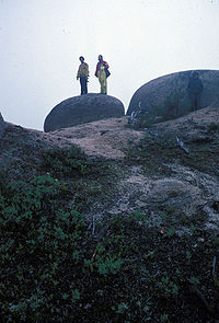
Tor (geography)
Encyclopedia

Rock (geology)
In geology, rock or stone is a naturally occurring solid aggregate of minerals and/or mineraloids.The Earth's outer solid layer, the lithosphere, is made of rock. In general rocks are of three types, namely, igneous, sedimentary, and metamorphic...
outcrop
Outcrop
An outcrop is a visible exposure of bedrock or ancient superficial deposits on the surface of the Earth. -Features:Outcrops do not cover the majority of the Earth's land surface because in most places the bedrock or superficial deposits are covered by a mantle of soil and vegetation and cannot be...
) that rises abruptly from the surrounding smooth and gentle slopes of a rounded hill
Hill
A hill is a landform that extends above the surrounding terrain. Hills often have a distinct summit, although in areas with scarp/dip topography a hill may refer to a particular section of flat terrain without a massive summit A hill is a landform that extends above the surrounding terrain. Hills...
summit
Summit (topography)
In topography, a summit is a point on a surface that is higher in elevation than all points immediately adjacent to it. Mathematically, a summit is a local maximum in elevation...
or ridge
Ridge
A ridge is a geological feature consisting of a chain of mountains or hills that form a continuous elevated crest for some distance. Ridges are usually termed hills or mountains as well, depending on size. There are several main types of ridges:...
crest. In the South West of England
South West England
South West England is one of the regions of England defined by the Government of the United Kingdom for statistical and other purposes. It is the largest such region in area, covering and comprising Bristol, Gloucestershire, Somerset, Dorset, Wiltshire, Devon, Cornwall and the Isles of Scilly. ...
, where the term originated, it is also a word used for the hills themselves – particularly the high points of Dartmoor
Dartmoor
Dartmoor is an area of moorland in south Devon, England. Protected by National Park status, it covers .The granite upland dates from the Carboniferous period of geological history. The moorland is capped with many exposed granite hilltops known as tors, providing habitats for Dartmoor wildlife. The...
in Devon
Devon
Devon is a large county in southwestern England. The county is sometimes referred to as Devonshire, although the term is rarely used inside the county itself as the county has never been officially "shired", it often indicates a traditional or historical context.The county shares borders with...
and Bodmin Moor
Bodmin Moor
Bodmin Moor is a granite moorland in northeastern Cornwall, England, United Kingdom. It is in size, and originally dates from the Carboniferous period of geological history....
in Cornwall
Cornwall
Cornwall is a unitary authority and ceremonial county of England, within the United Kingdom. It is bordered to the north and west by the Celtic Sea, to the south by the English Channel, and to the east by the county of Devon, over the River Tamar. Cornwall has a population of , and covers an area of...
.
Name
Wales
Wales is a country that is part of the United Kingdom and the island of Great Britain, bordered by England to its east and the Atlantic Ocean and Irish Sea to its west. It has a population of three million, and a total area of 20,779 km²...
, particularly on the rocky coastlines such as the Vale of Glamorgan
Vale of Glamorgan
The Vale of Glamorgan is a county borough in Wales; an exceptionally rich agricultural area, it lies in the southern part of Glamorgan, South Wales...
and the Gower Peninsula
Gower Peninsula
Gower or the Gower Peninsula is a peninsula in south Wales, jutting from the coast into the Bristol Channel, and administratively part of the City and County of Swansea. Locally it is known as "Gower"...
; on the Gower one of the sandy beaches near Oxwich Bay
Oxwich Bay
thumb|Oxwich Bay on the Gower Peninsula of South WalesOxwich Bay is a bay on the south of the Gower Peninsula, Wales.Its landscape features sand dunes, salt marshes and woodland. Oxwich Bay includes a 2.5-mile long sandy beach, accessible from the village of Oxwich. It is a popular spot for...
is called "Tor Bay" because the beach is framed by a huge outcrop of carboniferous limestone
Carboniferous limestone
Carboniferous Limestone is a term used to describe a variety of different types of limestone occurring widely across Great Britain and Ireland which were deposited during the Dinantian epoch of the Carboniferous period. They were formed between 363 and 325 million years ago...
. Tor (Cornish
Cornish language
Cornish is a Brythonic Celtic language and a recognised minority language of the United Kingdom. Along with Welsh and Breton, it is directly descended from the ancient British language spoken throughout much of Britain before the English language came to dominate...
tor, Old Welsh twrr, Modern Welsh tŵr, Scots Gaelic tòrr, meaning hill) is notable for being one among a mere handful of Celtic
Celtic languages
The Celtic languages are descended from Proto-Celtic, or "Common Celtic"; a branch of the greater Indo-European language family...
loanwords to be borrowed into vernacular English
English language
English is a West Germanic language that arose in the Anglo-Saxon kingdoms of England and spread into what was to become south-east Scotland under the influence of the Anglian medieval kingdom of Northumbria...
before the modern era – such borrowings are mainly words of a geographic or topographical
Topography
Topography is the study of Earth's surface shape and features or those ofplanets, moons, and asteroids...
nature, also including crag (from the Welsh
Welsh language
Welsh is a member of the Brythonic branch of the Celtic languages spoken natively in Wales, by some along the Welsh border in England, and in Y Wladfa...
word craig, meaning "rock") and "avon" (from the Welsh
Welsh language
Welsh is a member of the Brythonic branch of the Celtic languages spoken natively in Wales, by some along the Welsh border in England, and in Y Wladfa...
word afon, meaning "river").
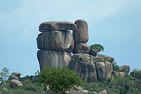
Tors are composed usually of granite
Granite
Granite is a common and widely occurring type of intrusive, felsic, igneous rock. Granite usually has a medium- to coarse-grained texture. Occasionally some individual crystals are larger than the groundmass, in which case the texture is known as porphyritic. A granitic rock with a porphyritic...
or metamorphic rock
Metamorphic rock
Metamorphic rock is the transformation of an existing rock type, the protolith, in a process called metamorphism, which means "change in form". The protolith is subjected to heat and pressure causing profound physical and/or chemical change...
s. Tors can also be found developed in volcanic rocks and occasionally other hard rocks such as quartzite
Quartzite
Quartzite is a hard metamorphic rock which was originally sandstone. Sandstone is converted into quartzite through heating and pressure usually related to tectonic compression within orogenic belts. Pure quartzite is usually white to gray, though quartzites often occur in various shades of pink...
, and are the result of millions of years of weathering
Weathering
Weathering is the breaking down of rocks, soils and minerals as well as artificial materials through contact with the Earth's atmosphere, biota and waters...
. In prehistoric times, when the land was covered in forest, rain water seeped into the ground and gradually weathered the bedrock through its natural cracks, or joints. Once the land became exposed, the weathering was accelerated, particularly during the Ice age
Ice age
An ice age or, more precisely, glacial age, is a generic geological period of long-term reduction in the temperature of the Earth's surface and atmosphere, resulting in the presence or expansion of continental ice sheets, polar ice sheets and alpine glaciers...
when freezing water expanded in the cracks. The result can be seen today in dramatic rock formations.
Weathering has also given rise to circular "rock basins'" formed by the accumulation of water and the repeated freezing and thawing – a fine example is to be found at Kes Tor on Dartmoor.
As the weathering of the tors continues, the rock is broken down into ever smaller sizes. Many hillsides are covered with loose rocks, known as clitter, which have provided ready building materials for thousands of years. Eventually the granite is weathered down to a level equivalent to sandy gravel
Gravel
Gravel is composed of unconsolidated rock fragments that have a general particle size range and include size classes from granule- to boulder-sized fragments. Gravel can be sub-categorized into granule and cobble...
, known as growan, which consists of individual crystal
Crystal
A crystal or crystalline solid is a solid material whose constituent atoms, molecules, or ions are arranged in an orderly repeating pattern extending in all three spatial dimensions. The scientific study of crystals and crystal formation is known as crystallography...
s.
The most distinctive granite landform in temperate countries is the tor and in tropical regions, the inselbergs
Monadnock
A monadnock or inselberg is an isolated rock hill, knob, ridge, or small mountain that rises abruptly from a gently sloping or virtually level surrounding plain...
. Both suggest the removal of material by solifluction
Solifluction
In geology, solifluction, also known as soil fluction, is a type of mass wasting where waterlogged sediment moves slowly downslope, over impermeable material. It occurs in periglacial environments where melting during the warm season leads to water saturation in the thawed surface material ,...
and hence lead to the opinion that tors and inselbergs are relict features.
Tors on Dartmoor
Dartmoor represents one of the largest areas of exposed granite in the United KingdomUnited Kingdom
The United Kingdom of Great Britain and Northern IrelandIn the United Kingdom and Dependencies, other languages have been officially recognised as legitimate autochthonous languages under the European Charter for Regional or Minority Languages...
, covering an area of 368 square miles (954 square kilometres). It is part of a chain of granite stretching through Cornwall, as far as the Isles of Scilly
Isles of Scilly
The Isles of Scilly form an archipelago off the southwestern tip of the Cornish peninsula of Great Britain. The islands have had a unitary authority council since 1890, and are separate from the Cornwall unitary authority, but some services are combined with Cornwall and the islands are still part...
.
Some of the more durable granite survived to form the rocky crowns of Dartmoor tors. One of the best known is at Haytor, on the eastern part of the moor, whose granite is of unusually fine quality and was quarried during the 19th and early 20th centuries. Its stone was used to construct the pillars outside the British Museum
British Museum
The British Museum is a museum of human history and culture in London. Its collections, which number more than seven million objects, are amongst the largest and most comprehensive in the world and originate from all continents, illustrating and documenting the story of human culture from its...
in London
London
London is the capital city of :England and the :United Kingdom, the largest metropolitan area in the United Kingdom, and the largest urban zone in the European Union by most measures. Located on the River Thames, London has been a major settlement for two millennia, its history going back to its...
, and to build London Bridge
London Bridge
London Bridge is a bridge over the River Thames, connecting the City of London and Southwark, in central London. Situated between Cannon Street Railway Bridge and Tower Bridge, it forms the western end of the Pool of London...
(now in Arizona
Arizona
Arizona ; is a state located in the southwestern region of the United States. It is also part of the western United States and the mountain west. The capital and largest city is Phoenix...
). The last granite to be quarried there was used to build Exeter
Exeter
Exeter is a historic city in Devon, England. It lies within the ceremonial county of Devon, of which it is the county town as well as the home of Devon County Council. Currently the administrative area has the status of a non-metropolitan district, and is therefore under the administration of the...
War Memorial in 1919.
Ten Tors
Ten Tors
Ten Tors is an annual weekend hike organised and run in early May for 2,400 young people by the British Army on Dartmoor. The majority of entrants are schools, colleges, Scout groups and Cadet squadrons from South West England, though groups from across the UK regularly take part, as do teams from...
is an annual weekend hike
Hiking
Hiking is an outdoor activity which consists of walking in natural environments, often in mountainous or other scenic terrain. People often hike on hiking trails. It is such a popular activity that there are numerous hiking organizations worldwide. The health benefits of different types of hiking...
on Dartmoor.
For a list of Dartmoor's tors see List of Dartmoor tors and hills.

United Kingdom
- Back Tor, Derwent EdgeDerwent EdgeDerwent Edge is a Millstone Grit escarpment that lies above the Upper Derwent Valley in the Peak District National Park in the English county of Derbyshire...
(538m) - Cow and Calf, Ilkley MoorIlkley MoorIlkley Moor is part of Rombalds Moor, the moorland between Ilkley and Keighley in West Yorkshire, England, United Kingdom. The peat bogs rise to 402 m above sea level...
in West YorkshireWest YorkshireWest Yorkshire is a metropolitan county within the Yorkshire and the Humber region of England with a population of 2.2 million. West Yorkshire came into existence as a metropolitan county in 1974 after the passage of the Local Government Act 1972....
. Made from Millstone GritMillstone GritMillstone Grit is the name given to any of a number of coarse-grained sandstones of Carboniferous age which occur in the Northern England. The name derives from its use in earlier times as a source of millstones for use principally in watermills...
. - Dovestone Tor, Derwent Edge (505m)
- Glastonbury TorGlastonbury TorGlastonbury Tor is a hill at Glastonbury, Somerset, England, which features the roofless St. Michael's Tower. The site is managed by the National Trust. It has been designated as a Scheduled Ancient Monument ....
- Great Tor, Bamford, Peak DistrictPeak DistrictThe Peak District is an upland area in central and northern England, lying mainly in northern Derbyshire, but also covering parts of Cheshire, Greater Manchester, Staffordshire, and South and West Yorkshire....
- Howshaw Tor, overlooking SheffieldSheffieldSheffield is a city and metropolitan borough of South Yorkshire, England. Its name derives from the River Sheaf, which runs through the city. Historically a part of the West Riding of Yorkshire, and with some of its southern suburbs annexed from Derbyshire, the city has grown from its largely...
- Ladybower Tor, Upper Derwent ValleyUpper Derwent ValleyThe Upper Derwent Valley is an area of the Peak District National Park in England. It largely lies in Derbyshire, but its north eastern area lies in Sheffield, South Yorkshire...
- Low tor
- Mam TorMam TorMam Tor is a hill near Castleton in the High Peak of Derbyshire, England. Its name literally translates as Heights of the Mother and it is also known as the Shivering Mountain on account of the instability of its lower shale layers...
(517m) - Shining TorShining TorShining Tor is a hill in the Peak District of England, between the towns of Buxton and Macclesfield, lying on the border between Derbyshire and Cheshire. Its summit is the highest point in Cheshire...
- StiperstonesStiperstonesThe Stiperstones is a very distinctive hill in the county of Shropshire, England. It is a quartzite ridge formed some 480 Million years ago. During the last Ice Age the summit stood out above the glaciers and was subject to constant freezing and thawing which shattered the quartzite into a mass of...
, Shropshire Hills - Over Owler Tor (375m)
- Higger TorHigger TorHigger Tor is a gritstone tor in the Burbage Valley, in the Peak District of England.It stands in the county of South Yorkshire, about from the border with Derbyshire, which runs along the nearest road, approximately east of Hathersage. Higger Tor overlooks the hill fort of Carl Wark to the...
(384m) - Whinstone Lee Tor
- White Tor, Derwent Moors (487m)
- The Barns of Bynack, Granite tors on Bynack MoreBynack MoreBynack More is a Scottish Mountain that is situated in the Cairngorms range, 16 kilometres east-south-east of the town of Aviemore in the Highland region.- Overview :...
in the CairngormsCairngormsThe Cairngorms are a mountain range in the eastern Highlands of Scotland closely associated with the mountain of the same name - Cairn Gorm.-Name:... - The Salt Cellar, Gritstone tor on Derwent EdgeDerwent EdgeDerwent Edge is a Millstone Grit escarpment that lies above the Upper Derwent Valley in the Peak District National Park in the English county of Derbyshire...
in the Peak DistrictPeak DistrictThe Peak District is an upland area in central and northern England, lying mainly in northern Derbyshire, but also covering parts of Cheshire, Greater Manchester, Staffordshire, and South and West Yorkshire.... - Tor Heard, Long WhattonLong WhattonLong Whatton is a village in the English county of Leicestershire. It is south of East Midlands Airport, off Junctions 23 and 23A of the M1 motorway, and has easy access to Loughborough via the A6 and to Shepshed, Ashby de la Zouch and Kegworth....
- Tor Raynor Broomhill, Sheffield
Germany
- ExternsteineExternsteineThe Externsteine are a distinctive rock formation located in Ostwestfalen-Lippe of northwestern Germany, not far from the city of Detmold at Horn-Bad Meinberg. The formation is a tor consisting of several tall, narrow columns of rock which rise abruptly from the surrounding wooded hills...
in the Teutoburg ForestTeutoburg ForestThe Teutoburg Forest is a range of low, forested mountains in the German states of Lower Saxony and North Rhine-Westphalia which used to be believed to be the scene of a decisive battle in AD 9...
, North Rhine-WestphaliaNorth Rhine-WestphaliaNorth Rhine-Westphalia is the most populous state of Germany, with four of the country's ten largest cities. The state was formed in 1946 as a merger of the northern Rhineland and Westphalia, both formerly part of Prussia. Its capital is Düsseldorf. The state is currently run by a coalition of the... - GreifensteineGreifensteineThe Greifensteine is a rock formation in the Ore Mountains, Germany, between the towns of Geyer, Ehrenfriedersdorf and Jahnsbach. The highest of the seven granite rocks reaches 731 m.- Geology :...
in the Ore Mountains of SaxonySaxonyThe Free State of Saxony is a landlocked state of Germany, contingent with Brandenburg, Saxony Anhalt, Thuringia, Bavaria, the Czech Republic and Poland. It is the tenth-largest German state in area, with of Germany's sixteen states.... - Großer WaldsteinGroßer WaldsteinThe Großer Waldstein is part of the Waldstein range in the Fichtelgebirge Mountains of Germany. It is known primarily for its rock formations caused by so-called 'woolsack' weathering , its ruined castles and the only remaining bear trap in the region.The River Saale rises at the foot of the...
in the FichtelgebirgeFichtelgebirgeThe Fichtelgebirge is a mountain range in northeastern Bavaria, Germany. It extends from the valley of the Red Main River to the Czech border, a few foothills spilling over into the Czech Republic. It continues in a northeastern direction as the Ore Mountains, and in a southeastern direction as...
mountains of BavariaBavariaBavaria, formally the Free State of Bavaria is a state of Germany, located in the southeast of Germany. With an area of , it is the largest state by area, forming almost 20% of the total land area of Germany... - HeinrichshöheHeinrichshöheThe Heinrichshöhe is a subsidiary peak of the Brocken and, at , the second highest elevation in the Harz Mountains. The summit lies about 1.4 km southeast of the top of the Brocken near the Brocken Road in the Harz National Park....
in the Harz mountains of central Germany - Hohneklippen in the Harz mountains of central Germany
- WolfensteinWolfenstein (rock)The Wolfenstein is an isolated rock formation, located between Tirschenreuth and Hohenwald in Bavaria.Due to erosion, the granite blocks appear to look like a pile of bags.- External links :* -* *...
in BavariaBavariaBavaria, formally the Free State of Bavaria is a state of Germany, located in the southeast of Germany. With an area of , it is the largest state by area, forming almost 20% of the total land area of Germany...
North America
- Angel Rocks, Chena River State Recreation AreaChena River State Recreation AreaChena River State Recreation Area is a 254,080-acre state park in the U.S. state of Alaska, located east of Fairbanks. The recreation area is centered around the Chena River. Facilities include campgrounds, hiking, ATV, snowmachine and sled dog trails, a shooting range, fishing ponds, and several...
, AlaskaAlaskaAlaska is the largest state in the United States by area. It is situated in the northwest extremity of the North American continent, with Canada to the east, the Arctic Ocean to the north, and the Pacific Ocean to the west and south, with Russia further west across the Bering Strait...
, - Granite Tors, Chena River State Recreation Area, Alaska
- Elephant RocksElephant Rocks State ParkElephant Rocks State Park in the U.S. state of Missouri encompasses an outcropping of Precambrian granite in the Saint Francois Mountains. It is named for a string of large granite boulders which resemble a train of pink circus elephants....
in MissouriMissouriMissouri is a US state located in the Midwestern United States, bordered by Iowa, Illinois, Kentucky, Tennessee, Arkansas, Oklahoma, Kansas and Nebraska. With a 2010 population of 5,988,927, Missouri is the 18th most populous state in the nation and the fifth most populous in the Midwest. It... - High TorHigh TorHigh Tor is a 1936 play by Maxwell Anderson. Twenty years after the original production, Anderson adapted it into a television musical with Arthur Schwartz.-Play:...
in New YorkNew YorkNew York is a state in the Northeastern region of the United States. It is the nation's third most populous state. New York is bordered by New Jersey and Pennsylvania to the south, and by Connecticut, Massachusetts and Vermont to the east... - Apache Leap Formation in Superior, Arizona
Africa
- Kit-MikayiKit-MikayiKit-Mikayi is a rock formation — a 70 meter high tor — on the Kisumu-Bondo road in western Kenya. It is situated about 29 kilometers west of the town of Kisumu. Kit-mikayi means “Stones of the first wife” or “First Wife Rocks” in Dholuo, the Luo language.-Description and location:Kit Mikayi...
, Kenya
See also
- List of peaks of the Peak District
- The book Red Shift (novel)Red Shift (novel)Red Shift is a fantasy novel by Alan Garner. It spans over a thousand years but one geographical area: Southern Cheshire, England. Garner evokes the essence of place, allowing his characters to echo each other through time, as if their destinies may be predefined by the soil on which they walk...
the Mow Cop Tor at the centre of its plot.