
Merrivale, Devon
Encyclopedia
Merrivale is a locality in western Dartmoor
, in the West Devon
district of Devon
, England
. It is best known for the nearby series of Bronze Age
megalithic monuments to the south and a former granite
quarry.
, which lies within the civil parish of Whitchurch
, is situated at the crossing of the River Walkham
on the B3357 (formerly the main Ashburton
to Tavistock road), midway between the towns of Princetown
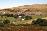
and Tavistock. There is an older disused bridge to the north of the modern road. The hamlet is dominated by the spoil tip from the former Merrivale granite
quarry (originally known as Tor Quarries), which closed in 1997. The few buildings include houses built originally for quarry workers and the Dartmoor Inn, which sells Merrivale Ale. There was once also a Wesleyan chapel.
, a stone circle
and a stone row
.
Also visible are two stone avenues running parallel to each other on either side of a stream. The southern avenue is 263.5 metres long and has the remains of a barrow in the middle. The northern avenue is slightly shorter. Both avenues are only about 1 metre wide down the centre. The southernmost double row has a kistvaen
set within the stone row. The eastern end of the rows is passed by a section of the Great Western Reave
, running roughly NW-SE.
To the south of the avenues is a large kistvaen
which contained a flint
scraper
, a number of flint flakes and a whetstone
for polishing metal items. The 'lid' of the cist was broken in two by a farmer sometime in the past who made a gatepost out of it. Numerous tors
are visible from the site, including King's Tor and Staple Tor.
The stone row was formerly known in the area as the Potato Market or Plague Market, supposedly since provisions for Tavistock were left here during an outbreak of plague. Crossing remarked on how insignificant the stones appear, given the size of some of the raw materials available.
More recent archaeology includes the remains of tin mining and smelting
along the River Walkham and its side streams.
sedimentary rocks of the Culm Measures
lower down and calc-silicate hornfels and intrusive dolerite at the summit. The Merrivale Granite is coarse grained, porphyritic
, with crystals that are dark grey, white/cream and orange in colour.
The Merrivale Site of Special Scientific Interest
(SSSI) to the north of the hamlet was the 4000th SSSI declared in England, in 1997. Besides the quarry it includes Cox Tor, Roos Tor and Staple Tors. It has a range of periglacial landscape features, including blockfields, boulder runs and boulder stripes, formed under tundra
conditions (arctic to sub-arctic climate) during the ]Pleistocene
. It is important in understanding how the landscape of South West England was formed, and how the granite tors of Devon and Cornwall were formed.
Dartmoor
Dartmoor is an area of moorland in south Devon, England. Protected by National Park status, it covers .The granite upland dates from the Carboniferous period of geological history. The moorland is capped with many exposed granite hilltops known as tors, providing habitats for Dartmoor wildlife. The...
, in the West Devon
West Devon
West Devon is a local government district and borough in Devon, England. Towns in the district include Chagford, Okehampton, Princetown, and Tavistock, where the council is based....
district of Devon
Devon
Devon is a large county in southwestern England. The county is sometimes referred to as Devonshire, although the term is rarely used inside the county itself as the county has never been officially "shired", it often indicates a traditional or historical context.The county shares borders with...
, England
England
England is a country that is part of the United Kingdom. It shares land borders with Scotland to the north and Wales to the west; the Irish Sea is to the north west, the Celtic Sea to the south west, with the North Sea to the east and the English Channel to the south separating it from continental...
. It is best known for the nearby series of Bronze Age
Bronze Age
The Bronze Age is a period characterized by the use of copper and its alloy bronze as the chief hard materials in the manufacture of some implements and weapons. Chronologically, it stands between the Stone Age and Iron Age...
megalithic monuments to the south and a former granite
Granite
Granite is a common and widely occurring type of intrusive, felsic, igneous rock. Granite usually has a medium- to coarse-grained texture. Occasionally some individual crystals are larger than the groundmass, in which case the texture is known as porphyritic. A granitic rock with a porphyritic...
quarry.
Merrivale hamlet
The hamletHamlet (place)
A hamlet is usually a rural settlement which is too small to be considered a village, though sometimes the word is used for a different sort of community. Historically, when a hamlet became large enough to justify building a church, it was then classified as a village...
, which lies within the civil parish of Whitchurch
Whitchurch, Devon
Whitchurch is a village just to the south-east of the town of Tavistock, Devon, England. It lies in the West Devon local authority area, and within Tavistock Deanery for ecclesiastical purposes...
, is situated at the crossing of the River Walkham
River Walkham
The Walkham is a river whose source is on Dartmoor, Devon, England. Flowing under Merivale and Huckworthy Bridges, the river reaches Horrabridge. About three miles further on, by a footbridge on the West Devon Way, it joins the River Tavy.-See also:...
on the B3357 (formerly the main Ashburton
Ashburton, Devon
Ashburton is a small town on the edge of Dartmoor in Devon, adjacent to the A38 Devon Expressway.It was formerly important as a stannary town , and remains the largest town within the National Park, with a population of around 3,500...
to Tavistock road), midway between the towns of Princetown
Princetown
Princetown is a town situated on Dartmoor in the English county of Devon.In 1785, Sir Thomas Tyrwhitt, Secretary to the Prince of Wales, leased a large area of moorland from the Duchy of Cornwall estate, hoping to convert it into good farmland. He encouraged people to live in the area and suggested...
and Tavistock. There is an older disused bridge to the north of the modern road. The hamlet is dominated by the spoil tip from the former Merrivale granite
Granite
Granite is a common and widely occurring type of intrusive, felsic, igneous rock. Granite usually has a medium- to coarse-grained texture. Occasionally some individual crystals are larger than the groundmass, in which case the texture is known as porphyritic. A granitic rock with a porphyritic...
quarry (originally known as Tor Quarries), which closed in 1997. The few buildings include houses built originally for quarry workers and the Dartmoor Inn, which sells Merrivale Ale. There was once also a Wesleyan chapel.
Archaeology
The main area of archaeological interest is to the south-east of the hamlet at . Although it has been diminished over time, the site includes a 3.8m standing stoneStanding stone
Standing stones, orthostats, liths, or more commonly megaliths are solitary stones set vertically in the ground and come in many different varieties....
, a stone circle
Stone circle
A stone circle is a monument of standing stones arranged in a circle. Such monuments have been constructed across the world throughout history for many different reasons....
and a stone row
Stone row
A stone row , is a linear arrangement of upright, parallel megalithic standing stones set at intervals along a common axis or series of axes, usually dating from the later Neolithic or Bronze Age. Rows may be individual or grouped, and three or more stones aligned can constitute a stone row...
.
Also visible are two stone avenues running parallel to each other on either side of a stream. The southern avenue is 263.5 metres long and has the remains of a barrow in the middle. The northern avenue is slightly shorter. Both avenues are only about 1 metre wide down the centre. The southernmost double row has a kistvaen
Kistvaen
A kistvaen or cistvaen is a tomb or burial chamber formed from flat stone slabs in a box-like shape. If set completely underground, it may be covered by a tumulus. The word is derived from the Welsh cist and maen...
set within the stone row. The eastern end of the rows is passed by a section of the Great Western Reave
Reave
A reave is a long and generally straight boundary wall made of stone that was built during the Bronze Age. Reaves were identified as prehistoric features on Dartmoor in Devon, England in 1972, and although they had been described by antiquarians in the 1820s, the knowledge of their origins had been...
, running roughly NW-SE.
To the south of the avenues is a large kistvaen
Kistvaen
A kistvaen or cistvaen is a tomb or burial chamber formed from flat stone slabs in a box-like shape. If set completely underground, it may be covered by a tumulus. The word is derived from the Welsh cist and maen...
which contained a flint
Flint
Flint is a hard, sedimentary cryptocrystalline form of the mineral quartz, categorized as a variety of chert. It occurs chiefly as nodules and masses in sedimentary rocks, such as chalks and limestones. Inside the nodule, flint is usually dark grey, black, green, white, or brown in colour, and...
scraper
Scraper (archaeology)
In archaeology, scrapers are unifacial tools that were used either for hideworking or woodworking purposes. Whereas this term is often used for any unifacially flaked stone tool that defies classification, most lithic analysts maintain that the only true scrapers are defined on the base of...
, a number of flint flakes and a whetstone
Sharpening stone
Sharpening stones, water stones or whetstones are used to grind and hone the edges of steel tools and implements. Examples of items that may be sharpened with a sharpening stone include scissors, scythes, knives, razors and tools such as chisels, hand scrapers and plane blades...
for polishing metal items. The 'lid' of the cist was broken in two by a farmer sometime in the past who made a gatepost out of it. Numerous tors
Tor (geography)
A tor is a large, free-standing residual mass that rises abruptly from the surrounding smooth and gentle slopes of a rounded hill summit or ridge crest...
are visible from the site, including King's Tor and Staple Tor.
The stone row was formerly known in the area as the Potato Market or Plague Market, supposedly since provisions for Tavistock were left here during an outbreak of plague. Crossing remarked on how insignificant the stones appear, given the size of some of the raw materials available.
More recent archaeology includes the remains of tin mining and smelting
Dartmoor tin-mining
The Dartmoor tin mining industry is thought to have originated in pre-Roman times, and continued right through to the 20th century. From the 12th century onwards tin mining was regulated by a Stannary Parliament which had its own laws....
along the River Walkham and its side streams.
Geology and geomorphology
Merrivale straddles the western edge of the Dartmoor granite outcrop. The hamlet, quarry and Staple Tors to the north are on the granite, while Cox Tor immediately to the west is on the metamorphic aureole, with altered CarboniferousCarboniferous
The Carboniferous is a geologic period and system that extends from the end of the Devonian Period, about 359.2 ± 2.5 Mya , to the beginning of the Permian Period, about 299.0 ± 0.8 Mya . The name is derived from the Latin word for coal, carbo. Carboniferous means "coal-bearing"...
sedimentary rocks of the Culm Measures
Culm Measures
The Culm Measures are a geological formation of the Carboniferous period that occur in south-west England, principally in Devon and Cornwall. They are so called because of the occasional presence of a soft, sooty coal, which is known in Devon as culm....
lower down and calc-silicate hornfels and intrusive dolerite at the summit. The Merrivale Granite is coarse grained, porphyritic
Porphyritic
Porphyritic is an adjective used in geology, specifically for igneous rocks, for a rock that has a distinct difference in the size of the crystals, with at least one group of crystals obviously larger than another group...
, with crystals that are dark grey, white/cream and orange in colour.
The Merrivale Site of Special Scientific Interest
Site of Special Scientific Interest
A Site of Special Scientific Interest is a conservation designation denoting a protected area in the United Kingdom. SSSIs are the basic building block of site-based nature conservation legislation and most other legal nature/geological conservation designations in Great Britain are based upon...
(SSSI) to the north of the hamlet was the 4000th SSSI declared in England, in 1997. Besides the quarry it includes Cox Tor, Roos Tor and Staple Tors. It has a range of periglacial landscape features, including blockfields, boulder runs and boulder stripes, formed under tundra
Tundra
In physical geography, tundra is a biome where the tree growth is hindered by low temperatures and short growing seasons. The term tundra comes through Russian тундра from the Kildin Sami word tūndâr "uplands," "treeless mountain tract." There are three types of tundra: Arctic tundra, alpine...
conditions (arctic to sub-arctic climate) during the ]Pleistocene
Pleistocene
The Pleistocene is the epoch from 2,588,000 to 11,700 years BP that spans the world's recent period of repeated glaciations. The name pleistocene is derived from the Greek and ....
. It is important in understanding how the landscape of South West England was formed, and how the granite tors of Devon and Cornwall were formed.