

Devonport Leat
Encyclopedia
Leat
A leat is the name, common in the south and west of England and in Wales, for an artificial watercourse or aqueduct dug into the ground, especially one supplying water to a watermill or its mill pond...
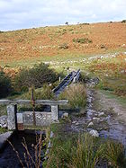
constructed in the 1790s to carry fresh drinking water from the high ground of Dartmoor
Dartmoor
Dartmoor is an area of moorland in south Devon, England. Protected by National Park status, it covers .The granite upland dates from the Carboniferous period of geological history. The moorland is capped with many exposed granite hilltops known as tors, providing habitats for Dartmoor wildlife. The...
to the expanding dockyards at Devonport, Devon
Devonport, Devon
Devonport, formerly named Plymouth Dock or just Dock, is a district of Plymouth in the English county of Devon, although it was, at one time, the more important settlement. It became a county borough in 1889...
, England. It is fed by three Dartmoor rivers: the West Dart
West Dart River
The West Dart River is one of the two main tributaries of the River Dart in Devon, England.Its source is near Lower White Tor 1.5 km north of Rough Tor on Dartmoor. It flows south to Two Bridges, then south east past Hexworthy to meet the East Dart River at Dartmeet...
, the Cowsic and the Blackabrook. It was originally designed to carry water all the way to Devonport Dockyard, but has since been shortened and the operational part of the leat now stops near the Burrator dam. The water goes via underground pipes to the water treatment works at Dousland with the excess going into the Burrator Reservoir
Burrator Reservoir
Burrator Reservoir is a reservoir on the south side of Dartmoor in the English county of Devon. It is one of a number of reservoirs and dams that were built over the course of the 19th and 20th centuries in the area now covered by Dartmoor National Park to supply drinking water to the rapidly...
which provides most of the water supply of Plymouth. For part of the route to Dousland the pipes utilise the route of the old Plymouth Leat and the route of the disused Yelverton to Princetown Railway. Prior to the installation of the piped supply to Dousland the water was used for a hydro electric turbine located near Yelverton Reservoir and fed by a 12 inches (304.8 mm) pipe.
Dartmoor granite
Granite
Granite is a common and widely occurring type of intrusive, felsic, igneous rock. Granite usually has a medium- to coarse-grained texture. Occasionally some individual crystals are larger than the groundmass, in which case the texture is known as porphyritic. A granitic rock with a porphyritic...
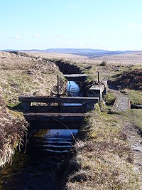
was used to construct the water channel, as well as a small aqueduct
Aqueduct
An aqueduct is a water supply or navigable channel constructed to convey water. In modern engineering, the term is used for any system of pipes, ditches, canals, tunnels, and other structures used for this purpose....
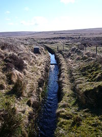
and a tunnel. It is possible to follow the path of the leat all the way from the beginning to the end of its path apart from one section where it passes through a tunnel.
Route
Wistman's Wood
Wistman's Wood is one of three remote copses of stunted oaks on Dartmoor, Devon, England. It lies at an altitude of between 380–420 metres in the valley of the West Dart River near Two Bridges, at grid reference SX613770....
and passes close to Two Bridges
Two Bridges
Two Bridges is an isolated location in the heart of Dartmoor National Park in Devon, England. It is situated around north east of Princetown on the old turnpike road which was built across Dartmoor in the late 18th century ....
before heading towards Princetown
Princetown
Princetown is a town situated on Dartmoor in the English county of Devon.In 1785, Sir Thomas Tyrwhitt, Secretary to the Prince of Wales, leased a large area of moorland from the Duchy of Cornwall estate, hoping to convert it into good farmland. He encouraged people to live in the area and suggested...
. Its water supply now ends up in Burrator Reservoir
Dartmoor reservoirs
Over the course of the 19th and 20th centuries, a number of reservoirs and dams were built in the area now covered by Dartmoor National Park in Devon, England to supply drinking water to the rapidly growing towns in the surrounding lowlands. With its deep valleys and high rainfall, Dartmoor was an...
. Judging by a map it might appear to follow a meandering path across the moor, but the route was carefully selected by skilled engineers, who followed the natural contours of the land.
Near the source of the leat there is a curious optical illusion
Optical illusion
An optical illusion is characterized by visually perceived images that differ from objective reality. The information gathered by the eye is processed in the brain to give a perception that does not tally with a physical measurement of the stimulus source...
; viewed from the opposite bank of the West Dart River between Two Bridges and Wistman's Wood, it appears to flow uphill.