

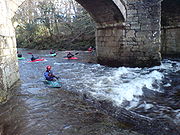
The Loop, River Dart
Encyclopedia


River Dart
The River Dart is a river in Devon, England which rises high on Dartmoor, and releases to the sea at Dartmouth. Its valley and surrounding area is a place of great natural beauty.-Watercourse:...
, Dartmoor
Dartmoor
Dartmoor is an area of moorland in south Devon, England. Protected by National Park status, it covers .The granite upland dates from the Carboniferous period of geological history. The moorland is capped with many exposed granite hilltops known as tors, providing habitats for Dartmoor wildlife. The...
, also known as the Dart Loop.
It is perhaps the most popular section of whitewater
Whitewater
Whitewater is formed in a rapid, when a river's gradient increases enough to disturb its laminar flow and create turbulence, i.e. form a bubbly, or aerated and unstable current; the frothy water appears white...
for kayakers and canoeists in England
England
England is a country that is part of the United Kingdom. It shares land borders with Scotland to the north and Wales to the west; the Irish Sea is to the north west, the Celtic Sea to the south west, with the North Sea to the east and the English Channel to the south separating it from continental...
. This section is preceded by the Upper Dart
Upper Dart
Upper Dart is a section of the River Dart, Dartmoor.It is perhaps the second most popular section of whitewater for kayakers and canoeists in England, particularly for experienced paddlers...
, and followed by The Lower.
Overview
The Loop is named as such because of the shape of its meanderMeander
A meander in general is a bend in a sinuous watercourse. A meander is formed when the moving water in a stream erodes the outer banks and widens its valley. A stream of any volume may assume a meandering course, alternately eroding sediments from the outside of a bend and depositing them on the...
, much like a loop of string.
This section's length is approximately 3 miles (4.8 kilometres), but to drive by car from start to finish is only 1.3 miles (2 kilometres) because of river and road geography.
This section is graded
International Scale of River Difficulty
The International Scale of River Difficulty is a standardized scale used to rate the safety of a stretch of river, or a single rapid. The grade reflects the technical difficulty and skill level required associated with the section of river...
at 2, with three rapids rated at grade 3. In very high water, some of the grade 2 sections will become continuous and push towards grade 3.
List of rapids
Most of the rapids have been named by watersports enthusiasts, and are officially referred to in guidebooks, such as English White Water: The British Canoe Union Guidebook.In order of each rapid, they are:
Newbridge rapid
The first rapid is Newbridge itself, a small wave formed before the bridge which can be played on at low-medium levels, washes out at high levels.Top wave
About 50 metres from NewbridgeNewbridge, River Dart
Newbridge or New Bridge is a Grade II* listed medieval bridge over the River Dart, Dartmoor, Devon, England. It is on the road between Ashburton and Two Bridges, and connects Aish Tor to Holne Chase...
is river-wide wave, which gets better with more water going over it. Very popular with playboaters
Playboating
Playboating is a discipline of whitewater kayaking or canoeing where the paddler performs various technical moves in one place , as opposed to downriver whitewater canoeing or kayaking where the objective is to travel the length of a section of river...
, with eddy
Eddy (fluid dynamics)
In fluid dynamics, an eddy is the swirling of a fluid and the reverse current created when the fluid flows past an obstacle. The moving fluid creates a space devoid of downstream-flowing fluid on the downstream side of the object...
service on both sides, and a bankside walk back to the car park.
Many grade 1–2 rapids follow. The river splits, with a gauge on the island, following that the River Webburn joins. Here a seam between the two river currents form, allowing squirtboaters
Squirt Boating
Squirt boating is a form of whitewater kayaking or canoeing where the boat is designed to be as low in volume as possible while still allowing the paddler to float. Squirt boats are designed to utilize both surface and underwater currents to manoeuvre within the water...
to practise their sport.
Washing machine
A 1 metre grade 3 drop, with a stopper and wave train beneath it. The lead in pushes you right, the river left is where you need to manoeveure to.In high to very levels the stopper is quite formiddable for novices; hence the name. Low-medium levels require little effort to pass through.
More rapids follow, along with seal-launch rock, a tall sloping rock which can be slid down.
Lover's leap
This involves a 100 m grade 3 rapid, which requires rock evasion and a final wave train which pushes one into the leap itself: a large undercut cliff-face. In anything but high flows this is easily avoided, but can still cause pinning potential with inexperienced paddlers.Several wide and continuous rapids follow Lover's Leap. However just before the next grade-3 rapid, a small but sticky stopper appears without warning. This needs to be taken mid-river or one could end up being back-looped, and going over Triple-drop in an awkward position.
Triple-drop / Triple-falls
The most difficult grade 3 rapid on this section of the Dart. Luckily inspection, and if necessary portage are available on both sides of the river.- The first drop is a half metre ledge. A pour-over type hole in low levels .
- Second drop is a big wave/stopper into a pool.
- The last drop is harder, requiring you to take the centre line followed by a move to the left or right, avoiding the centre which turns into a sticky stopper at most levels.
Each drop has small eddies on both sides of the river, and the pool after the third drop is flat allowing boats and people to be rescued at the river bank.
More grade 1/2 rapids follow before you reach the Spindryer.
Spindryer
At high levels this rapid can be harder, especially if taken on river right, leaving you in the fast-rotating eddy the rapid is named after. If caught, a fast break-in is needed and possibly a surf across the wave that forms next to it. River left is the ideal place to aim for.More small rapids follow.
Haystack rapids
The last notable rapid on the river before Holne BridgeHolne Bridge
Holne Bridge is a Grade II* listed medieval bridge over the River Dart, Dartmoor, Devon, England. It is on the road between Ashburton and Two Bridges, and connects Holne Chase to Ausewell...
, which works best in medium to high levels. Reasonably large but predictable breaking waves carry you 50-80 metres down to Holne Bridge.
Holne Bridge: take out
The Riverdart Country Park charges during the paddling season £5 per car or £10 per minibus for the day. Parking is free after 4 pm for visitors wanting to use the bar and restaurant. Paddlers are issued with a car pass to enable them to drive in and out of the park to run shuttles to and from Newbridge/Dartmeet/Buckfastleigh. Day visitors also have use of the toilet facilities and communal hot showers on Saturdays and Sundays. The Old Sawmill is open at weekends and offers a Sunday Carvery lunch from noon to 3 pm.A feasible, though fairly long, alternative is to continue down the river to Buckfastleigh
Buckfastleigh
Buckfastleigh is a small market town and civil parish in Devon, England situated beside the Devon Expressway at the edge of the Dartmoor National Park. It is part of Teignbridge District and, for ecclesiastical purposes lies within the Totnes Deanery. It has a population of 3,661...
where in the winter there is ample parking. This section, the Lower Dart or just "Lower" is grade 2 with some flat sections.
Holne weir
In medium to high levels this is a highly retentive stopper and should be treated with caution. Two chutes allow access through, and should not be missed. The lead-in is flat, and is easy to achieve. Portage on the bank is also possible.Another small rapid follows, with the Anvil; a rententive playspot
Playspot
A playspot is a term used by kayakers and canoeists to describe favorable stationary features on rivers, in particular standing waves , 'holes' and 'stoppers', where water flows back on itself creating a retentive feature , or eddy lines A playspot is a term used by kayakers and canoeists to...
.
External links
- Official Dartmoor website regarding Canoeing and Kayaking