
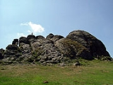
, Devon
. The tramway was built in 1820 to carry Haytor granite
, which was of fine grain and high quality, down from the heights of Dartmoor for the construction of houses, bridges and other structures. In 1850 the quarries employed about 100 men but by 1858 they had closed due to the availability of cheaper Cornish
granite.
Operation and purpose
The granite from the quarries near Haytor Rock was transported some 10 miles (16.1 km) horizontally and 1300 feet (396.2 m) vertically to the basin of the Stover Canal by a remarkable plateway, of a type unique in south-west Britain. This line, built in 1820, was a 'flanged way' – that is, the guiding flanges that kept the waggons on the rails were integrated with the rails. The unique feature of the Haytor line was that the rails or 'tramplates', rather than being the customary regular sections of cast iron carried on stone block sleepers, were hewn from irregular blocks of solid granite laid directly on the ground. The gauge of the track was , and at turnouts (points) the wheels were guided by wooden 'point tongues' of oak, pivoted on the granite-block rails. In the upward direction, the empty trams were pulled to the quarries by teams of horses; the loaded trams were run downhill by gravity to the Stover Canal
basin at Ventiford, Teigngrace.
The gradients were such that no single part of the line required more horses to be added as 'assisting engine
s'. A siding at Manaton
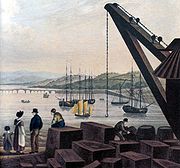
Road may have been used to allow trains to pass. The Stover Canal had been built by James Templer, Esq. in 1770 or January 1790 for the clay traffic and was extended to Teigngrace by James in 1820. From here the granite was carried by canal boat to the New Quay at Teignmouth
for export by ship, the quay having been built in 1827 for the purpose, making midstream transshipment
no longer necessary. In 1829, due to financial difficulties, George Templer sold Stover house, the canal and the tramway to Edward Adolphus Seymour, the eleventh Duke of Somerset. George Templer left Devon, only to return a few years later, building a new mansion at Sandford Orleigh on the outskirts of Newton Abbot
. He became the granite company's chief Devonshire agent.
Accidents were not uncommon as the only braking was provided by the horses and long wooden poles forced against the wheels. Early accounts refer to the 'rail-road' without always commenting on its 'granite' nature as any form of rail-road was a rarity at the time. Iron mines existed nearby, but the short cast iron
rails of the time were very prone to breaking and the granite was an ideal substitute.
The wooden flat-topped waggons had iron flangeless wheels and ran in trains of usually twelve waggons drawn by around 18 horses in single file, in front for the upward journey and at the rear for the downward. An old sailor called Thomas Taverner wrote a poem which gives us this information:
The vehicles used were probably adapted road waggons and were about 13 feet (3.96 m) long, with a wheelbase of 10 ft (3.05 m). The wheels were 2 ft (610 mm) in diameter with a 3 inches (76.2 mm) tread, and were loose on the axles. The twelve-wheeled reference in the poem above means 'twelve waggons with wheels'.

. Part of the British Museum
, the old General Post Office in London and the Waltham Monument in Ludgate Circus
were built of Haytor granite in the 19th century. The last use of Haytor quarried granite was the building of the Exeter War Memorial.
The splitting of the granite was done by a method known as feather and tare
, which had replaced the former 'wedge and groove' method around 1800; this more reliable method being another reason why the use of granite had become practicable. The new method worked by means of a series of holes was made along a potential line of fracture using a tool called a 'jumper'. Feathers were metal prongs with a curved upper end. Two of these were inserted into the holes, the curves in opposite directions at 90 degrees to the line of potential fracture. A wedge-shaped metal tare was hammered between the two until the granite fractured.
The granite trade was always somewhat sporadic with fluctuating production and indeed no granite was produced or transported between 1841 and 1851 and the quarries and tramway had closed by 1858. Several thousands of tons of granite had been quarried some years, but competition from Cornish granite quarries with cheaper transport put paid to the business and the tramway fell into neglect, however its robust construction and low recyclable value meant that it was never lifted and much has survived the passage of time.
Construction
The tramway was built in 1820 without an Act of Parliament and opened on 16 September 1820, but the consulting engineer is unknown, although George Templer of Stover House managed the quarries and was no doubt responsible. The description of the official opening shows the extent of the achievement:
On Saturday Mr. Templer, of Stover House, gave a grand fete champetre
Fête champêtreA Fête champêtre was a popular form of entertainment in the 18th century, taking the form of a garden party. This form of entertainment was particularly popular at the French court where at Versailles areas of the park were landscaped with follies, pavilions and temples to accommodate such...
on Haytor Down, on the completion of the granite rail road. The company assembled at its foot on Bovey Heathfield, and in procession passed over it to the rock. A long string of carriages, filled with elegant and beautiful females, multitudes of horsemen, the workmen on foot, the waggons covered with laurels and waving streamers, formed in their windings through the valley, an attractive scene to spectators on the adjacent hill. Old Haytor seemed alive: its sides were lined with groups of persons, and on its top a proud flag fluttered in the wind.
Among the company were Lord & Lady Clifford of Ugbrooke; Mr. Bastard from Buckland; Sir Thomas Dyke Acland; Sir Henry Carew from Haccombe; Sir Lawrence Palk from Haldon, beside many other county magnates from other parts. After a speech by Mr. Templer there were high jinks and dances on the turf. "Never", writes the ecstatic reporter of an Exeter paper, "was the Haytor's sod graced with such blooming fair ones, nor did it ever before display so festive a scene."
The construction is unique, the closest possibly being the Weedon Stoneway in Northamptonshire of 1837 which was built at great expense as a mail coach route by the Turnpike Commissioners who were in competition with the newly constructed London & Birmingham Railway. The only other comparable tramway known to exist was a very short 3 ft gauge limestone line at Conisbrough
, near Doncaster
.
. At first, it was about 7 miles (11.3 km) long, but it was later extended to about 9 miles (14.5 km) or 10 miles (16.1 km) including the various sidings. The hard granite stone was well-suited to the purpose as it can withstand high pressures and was laid in lieu of iron rails. The tramway had a mainline running down to the Stover canal and six branches or sidings running from the separate quarries. The sidings were altered several times during the existence of the line and track was often lifted and used elsewhere as circumstances demanded. Various minor and one substantial cutting, small embankments and a few short bridges exist along the length of the line.
" from which trucks were directed down different lines of the tramway, originally with a movable 'iron shoe' portion to direct the trains. Parts of the old track are now to be found in hedges, walls, bridges and gardens. The granite rails had L-shaped grooves with the flanges on the inside and ran a parallel course, whilst some of the points were large blocks of solid granite
. The gauge of track was at the flanges and overall 5.5 ft (1.676 m), with the inside of blocks 3 ft (914 mm). It was officially set at but varied a little outwith the points as the gauge was held only by the weight and size of the granite setts. The setts were 15 inches (381 mm) wide, the inside kerbs being 2 or high. The rail granite setts were between 4 and 8 ft (1.2 and 2.4 m) long, curves being achieved by laying a series of short 'rails' on the inside of the curves. The iron wheels soon wore the straight granite flanges to shape on the curves.
Route
Carrington in the late 1820s relates how the rail-road can be used as a route, for pedestrians or those on horseback, from Haytor to Teigngrace, making the point that a tramway usually differs from a railway by effectively being part of a road and also that the frequency of the granite traffic was usually low and slow moving, so passage along the route by the public on foot or horseback would not have been particularly hazardous. It may be that pedestrians and riders were asked to paya toll as on the Kilmarnock and Troon Railway
in Ayrshire
, Scotland
.
| Etymology |
| The name Haytor is of comparatively recent origin, probably a corruption of its old name and that of the Haytor Hundred. Idetordoune (1566), Ittor Doune (1687), Idetor (1737) and Eator Down (1762) are a few recorded examples of the names given to this prominent Dartmoor Dartmoor Dartmoor is an area of moorland in south Devon, England. Protected by National Park status, it covers .The granite upland dates from the Carboniferous period of geological history. The moorland is capped with many exposed granite hilltops known as tors, providing habitats for Dartmoor wildlife. The... feature. |
Milestone
s were erected and three remained in 1975. These were at 3 miles (4.8 km) close to the former Bovey Potteries, Milestone 4 in a copse just south of the road from Bovey Tracey
to Haytor near Lowerdown Cross and Milestone 6 on the north side of the same road to Haytor, soon after it reaches the open commons at the eastern end of Haytor Down. The miles were measured from Ventiford. Passengers were never carried and the milestones may have been a whim on behalf of George Templer. Granite seems to have been the only traffic carried as the company was reluctant to go to the expense of building high-sided waggons or trucks for iron ore transportation.
The building of the Moretonhampstead and South Devon Railway
in 1866 meant that the tramway could be shortened and the new interchange sidings were at the 'Bovey Granite Siding', 1 miles (1.6 km) south of Bovey Tracey. A mile of the old tramway route had been required for the new line, however the tramway had not been used since 1858. Nonetheless, the land owner, the Duke of Somerset
, insisted that a siding and a crane should be built; it was probably never used.
The 1831 map of Devonshire by Fisher, Son & Co. depicts the course of the tramway and erroneously shows it running directly down to the Teign without the Stover canal being in existence. A circa 1865 Devonshire map shows the line as still existing, but the new Moretonhampstead
branch cuts it off at Teigngrace as already stated.
The planned electric tramway
In about 1905 there was a scheme to electrify the line and run a frequent tram service, however this failed to mature. A small power station was built for it however, using Bovey coal to make gas to drive the generator. It was used by the potteries until falling into ruins.The Templer Way

between Haytor and Newton Abbot
. It then follows the old exporting route for the granite down to the New Quay in Teignmouth
docks. A good place to see the track is where it crosses a minor road which leads to Manaton
, just off the Haytor to Bovey Tracey
road. The upper section has been designated an Ancient Monument.
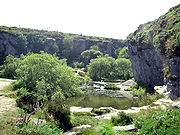
Once off the moor the place to see the track at its best is a small section of the tramway running through Yarner woods
, there is also a well-made five mile (8 km) marker stone. The granite track sections can be followed through the woods before the pathway diverts back onto the main Bovey Tracey road. The tramway cuts across fields down to the road which runs beside the Edgemoor Hotel and a few track setts lie scattered on the lawn of this hotel, but no clear line of the track can be distinguished. Chapple Bridge was the only bridge on the tramway, crossing the Bovey leat
, until the opening of the second quarry at Holwell Tor. Ventiford Cottages were built to house employees who worked on the tramway and canal, although some lived in a collection of small houses clustered around the inn which lay below Haytor Rocks. Stables were also maintained here for the horses that worked the canal and the railway. Granite setts can clearly be seen in the construction of bridges on the route of the Templer Waybridge.
Miscellaneous
The Haytor rocks and quarries are protected from development and disturbance as a Site of Special Scientific Interest.
In 1936 a Mr. Jeffrys-Jones presented a piece of trackwork to the Science Museum, probably for use in an exhibition which told the story of early trackwork.
See also
- British quarrying and mining narrow gauge railwaysBritish quarrying and mining narrow gauge railwaysBritish industrial narrow gauge railways are narrow gauge railways in the United Kingdom and the Isle of Man that were primarily built to serve one or more industries. Some offered passenger services for employees or workmen, but they did not run public passenger trains...
- Haytor
- Ilsington
- Stover CanalStover CanalThe Stover Canal is a canal located in Devon, England. It was opened in 1792 and served the ball clay industry until it closed in the early 1940s. Today it is derelict, but the Stover Canal Society is aiming to restore it and reopen it to navigation.-History:...