

Weald Basin
Encyclopedia
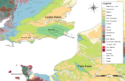
The Weald Basin was a major topographic feature of southern England and northern France from the Triassic to the late Cretaceous, its uplift in the late Cretaceous marked the formation of the Wealden Anticline.
 The basins formation commenced during Carboniferous
, with the rocks which are today basement deposited within a low swamp providing coals which were exploited to the north and east in Kent
, but boreholes drilled in the 19th century failed to find this deposit in the area of the Weald. The Carboniferous coals are overlain by Silurian and early Triassic sediments. The sediments where uplifted and faulted within the Variscan Orogeny
, with the land now occupied by the Weald Basin being a low external fold belt to the main orogeny, which was located within the present day English Channel , the remnants of the mountain belt can be seen today in Devon and Cornwall in what is known as the Cornubian Massif. The deformation caused, unlike in Devon and Cornwall, little or no metamorphism.
The mountain belt collapsed soon after the orogeny leading to the former northward thrusts to be reactivated as normal faults and lead to the formation of the Weald basin which developed as an extension of the considerably larger Wessex Basin
. Reconstructions of the geometry of the early fault systems in the Weald Basin reveal that for the early history of the basin a series of steep normal faults to the north were active against the London-Brabant Massif, but it is not clear whether this reflects a syn-rift
origin for these rocks. The Weald basin gently subsided throughout the Jurassic, Cretaceous and Early Tertiary leading to a thick succession of sedimentary rocks being deposited. During the Early Jurrasic a north and east shallowing mud-dominated shelf developed .
 As a result of the Alpine orogeny the basin was squeezed between the basement to the north and the south, this resulted in the reactivation
of the formerly normal faults into minor thrusts (as they had been during the Variscan Orogeny
) and the formation of the Wealden Anticline
. The region's two surface structural highs (areas of crust and rocks which are uplifted), the Wealden Anticline
and the Channel High, are superimposed upon earlier, Mesozoic basins, (the Weald and Channel basins). This nearly exact superimposition of compressional features upon underlying formerly extensional features exemplifies perfectly the principles of structural inversion across a large and well defined geologic feature.
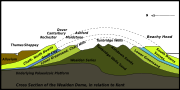
The overall uplift produced by the Tertiary
inversion
in the eastern Wealden basin has been estimated to be as much as 1525 m; which as a result of the large amount of Mesozoic
sediments does not reveal the underlying Paleozoic
basement. Utilising estimations of the original thickness of Chalk
(400–460 m) and other Mesozoic strata indicate a complex fold structure which, in the event it was not eroded during uplift, attained a crestal elevation of 1400 m over what is today Ashdown Forest
.. However it is likely that erosion kept pace with uplift, resulting in large quantities of sediment supply to the North Sea and the English Channel
while drilling for water at Heathfield railway station
, which was utilised to provide the first gas lighting in the UK. and the existence of the same rocks within the Weald basin which are the source rocks for the Wytch Farm
oilfield lead to an interest in the petroleum potential of the Wealden anticline, with exploration taking place on Ashdown forest examining the Ashdown Anticline, a large structure over 30 km long x 7 km wide, located in the centre of the Weald Basin in north Sussex
; significant quantities of natural gas where found but oil was absent. The Weald Basin, however has yielded significant quantities of gypsum
from Jurassic
Purbeck beds and a number of brickworks exploit the lower Cretaceous
clays.
Carboniferous
The Carboniferous is a geologic period and system that extends from the end of the Devonian Period, about 359.2 ± 2.5 Mya , to the beginning of the Permian Period, about 299.0 ± 0.8 Mya . The name is derived from the Latin word for coal, carbo. Carboniferous means "coal-bearing"...
, with the rocks which are today basement deposited within a low swamp providing coals which were exploited to the north and east in Kent
Kent coalfield
The Kent Coalfield was a coalfield located in the eastern part of the English county of Kent.Coal was discovered in the area in 1890 while borings for an early Channel Tunnel project were taking place and the resultant Shakespeare colliery lasted until 1915...
, but boreholes drilled in the 19th century failed to find this deposit in the area of the Weald. The Carboniferous coals are overlain by Silurian and early Triassic sediments. The sediments where uplifted and faulted within the Variscan Orogeny
Variscan orogeny
The Variscan orogeny is a geologic mountain-building event caused by Late Paleozoic continental collision between Euramerica and Gondwana to form the supercontinent of Pangaea.-Naming:...
, with the land now occupied by the Weald Basin being a low external fold belt to the main orogeny, which was located within the present day English Channel , the remnants of the mountain belt can be seen today in Devon and Cornwall in what is known as the Cornubian Massif. The deformation caused, unlike in Devon and Cornwall, little or no metamorphism.
The mountain belt collapsed soon after the orogeny leading to the former northward thrusts to be reactivated as normal faults and lead to the formation of the Weald basin which developed as an extension of the considerably larger Wessex Basin
. Reconstructions of the geometry of the early fault systems in the Weald Basin reveal that for the early history of the basin a series of steep normal faults to the north were active against the London-Brabant Massif, but it is not clear whether this reflects a syn-rift
Rift
In geology, a rift or chasm is a place where the Earth's crust and lithosphere are being pulled apart and is an example of extensional tectonics....
origin for these rocks. The Weald basin gently subsided throughout the Jurassic, Cretaceous and Early Tertiary leading to a thick succession of sedimentary rocks being deposited. During the Early Jurrasic a north and east shallowing mud-dominated shelf developed .
Basin reactivation
Inversion (geology)
In structural geology inversion or basin inversion relates to the relative uplift of a sedimentary basin or similar structure as a result of crustal shortening. This normally excludes uplift developed in the footwalls of later extensional faults, or uplift caused by mantle plumes...
of the formerly normal faults into minor thrusts (as they had been during the Variscan Orogeny
Variscan orogeny
The Variscan orogeny is a geologic mountain-building event caused by Late Paleozoic continental collision between Euramerica and Gondwana to form the supercontinent of Pangaea.-Naming:...
) and the formation of the Wealden Anticline
Weald-Artois Anticline
The Weald–Artois anticline is a large anticline, a geological structure running between the regions of the Weald in southern England and the Artois in northeastern France. The fold formed during the Alpine orogeny, from the late Oligocene to middle Miocene as an uplifted form of the Weald basin...
. The region's two surface structural highs (areas of crust and rocks which are uplifted), the Wealden Anticline
Weald-Artois Anticline
The Weald–Artois anticline is a large anticline, a geological structure running between the regions of the Weald in southern England and the Artois in northeastern France. The fold formed during the Alpine orogeny, from the late Oligocene to middle Miocene as an uplifted form of the Weald basin...
and the Channel High, are superimposed upon earlier, Mesozoic basins, (the Weald and Channel basins). This nearly exact superimposition of compressional features upon underlying formerly extensional features exemplifies perfectly the principles of structural inversion across a large and well defined geologic feature.
The overall uplift produced by the Tertiary
Tertiary
The Tertiary is a deprecated term for a geologic period 65 million to 2.6 million years ago. The Tertiary covered the time span between the superseded Secondary period and the Quaternary...
inversion
Inversion (geology)
In structural geology inversion or basin inversion relates to the relative uplift of a sedimentary basin or similar structure as a result of crustal shortening. This normally excludes uplift developed in the footwalls of later extensional faults, or uplift caused by mantle plumes...
in the eastern Wealden basin has been estimated to be as much as 1525 m; which as a result of the large amount of Mesozoic
Mesozoic
The Mesozoic era is an interval of geological time from about 250 million years ago to about 65 million years ago. It is often referred to as the age of reptiles because reptiles, namely dinosaurs, were the dominant terrestrial and marine vertebrates of the time...
sediments does not reveal the underlying Paleozoic
Paleozoic
The Paleozoic era is the earliest of three geologic eras of the Phanerozoic eon, spanning from roughly...
basement. Utilising estimations of the original thickness of Chalk
Chalk
Chalk is a soft, white, porous sedimentary rock, a form of limestone composed of the mineral calcite. Calcite is calcium carbonate or CaCO3. It forms under reasonably deep marine conditions from the gradual accumulation of minute calcite plates shed from micro-organisms called coccolithophores....
(400–460 m) and other Mesozoic strata indicate a complex fold structure which, in the event it was not eroded during uplift, attained a crestal elevation of 1400 m over what is today Ashdown Forest
Ashdown Forest
Ashdown Forest is an ancient area of tranquil open heathland occupying the highest sandy ridge-top of the High Weald Area of Outstanding Natural Beauty. It is situated some south of London in the county of East Sussex, England...
.. However it is likely that erosion kept pace with uplift, resulting in large quantities of sediment supply to the North Sea and the English Channel
Economic resources
The inversion of the Weald Basin throughout the late Cretaceous and early Tertiary resulted in the formation of the Wealden Anticline and a number of smaller anticlines within the larger structure, The discovery of natural gasNatural gas
Natural gas is a naturally occurring gas mixture consisting primarily of methane, typically with 0–20% higher hydrocarbons . It is found associated with other hydrocarbon fuel, in coal beds, as methane clathrates, and is an important fuel source and a major feedstock for fertilizers.Most natural...
while drilling for water at Heathfield railway station
Heathfield (Sussex) railway station
Heathfield railway station was on the Cuckoo Line between Horam and Mayfield, serving the market town of Heathfield.It was built in 1880 by London, Brighton and South Coast Railway on the line extension from Hailsham to Eridge.- Present day :...
, which was utilised to provide the first gas lighting in the UK. and the existence of the same rocks within the Weald basin which are the source rocks for the Wytch Farm
Wytch Farm
Wytch Farm is an oil field and processing facility in the Purbeck district of Dorset, England. It is the largest onshore oil field in western Europe. The facility, operated by BP, is hidden in a coniferous forest on Wytch Heath on the southern shore of Poole Harbour, two miles north of Corfe Castle...
oilfield lead to an interest in the petroleum potential of the Wealden anticline, with exploration taking place on Ashdown forest examining the Ashdown Anticline, a large structure over 30 km long x 7 km wide, located in the centre of the Weald Basin in north Sussex
Sussex
Sussex , from the Old English Sūþsēaxe , is an historic county in South East England corresponding roughly in area to the ancient Kingdom of Sussex. It is bounded on the north by Surrey, east by Kent, south by the English Channel, and west by Hampshire, and is divided for local government into West...
; significant quantities of natural gas where found but oil was absent. The Weald Basin, however has yielded significant quantities of gypsum
Gypsum
Gypsum is a very soft sulfate mineral composed of calcium sulfate dihydrate, with the chemical formula CaSO4·2H2O. It is found in alabaster, a decorative stone used in Ancient Egypt. It is the second softest mineral on the Mohs Hardness Scale...
from Jurassic
Jurassic
The Jurassic is a geologic period and system that extends from about Mya to Mya, that is, from the end of the Triassic to the beginning of the Cretaceous. The Jurassic constitutes the middle period of the Mesozoic era, also known as the age of reptiles. The start of the period is marked by...
Purbeck beds and a number of brickworks exploit the lower Cretaceous
Cretaceous
The Cretaceous , derived from the Latin "creta" , usually abbreviated K for its German translation Kreide , is a geologic period and system from circa to million years ago. In the geologic timescale, the Cretaceous follows the Jurassic period and is followed by the Paleogene period of the...
clays.