
Ivinghoe Beacon
Encyclopedia
Ivinghoe Beacon is a prominent hill and landmark in the Chiltern Hills
, standing 233 m (757 ft) above sea level. It is situated close to the villages of Ivinghoe
, Aldbury
in Buckinghamshire
, the Ashridge
Estate, and the village of Little Gaddesden
in Hertfordshire, and is managed and owned by the National Trust
. Ivinghoe Beacon lies between the towns of Dunstable
, Berkhamsted
and Tring
. It is the starting point of the Icknield Way
to the east, and the Ridgeway
long-distance path
to the west.
Contrary to popular claims, Ivinghoe Beacon does not rise to 249m above sea level as some sources have been mislead to believe. This is the highest elevation of the nearby Clipper Down,of which a trig point
of the same name rises to 249m above sea level, and thus incorporating it as the highest point in the east of england.
Beacon Hill, as it is formally known on OS Maps, actually rises to 233m, 16 metres lower than it's neighbour. The precise summit height is ambiguous, as the Ridgeway marker sits at the summit of the hill at 233m, with a trig point
sited a few metres away and slightly lower at 231m.
While physically quite prominent, the Beacon is not the highest point in the Chilterns, which is a few miles to the west at Haddington Hill
near Wendover
. Despite this, there is an indication that Ivinghoe Beacon has a line of site to a landmark in Blue Bell Hill
in Kent
. Some 61 miles away to the east.
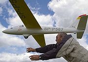
The Beacon is a popular spot for walkers, sightseers and model aircraft
enthusiasts, who use lift generated by the wind blowing up the hill - a technique known as slope soaring.
Ivinghoe Beacon's appearance of remoteness, yet relative proximity to the film studios at Elstree
meant that it was a favoured location for many dramas, especially those produced by ITC
in the 1960s.

Chiltern Hills
The Chiltern Hills form a chalk escarpment in South East England. They are known locally as "the Chilterns". A large portion of the hills was designated officially as an Area of Outstanding Natural Beauty in 1965.-Location:...
, standing 233 m (757 ft) above sea level. It is situated close to the villages of Ivinghoe
Ivinghoe
Ivinghoe is a village and civil parish within Aylesbury Vale district in Buckinghamshire, England, close to the border with Hertfordshire and Bedfordshire. It is four miles north of Tring and six miles south of Leighton Buzzard, close to the village of Pitstone.The village name is Anglo-Saxon in...
, Aldbury
Aldbury
Aldbury is a village and civil parish in Hertfordshire, England, near the borders of Bedfordshire and Buckinghamshire, in a valley close to Ashridge Park. The nearest town is Tring; Tring railway station, 1 mile west, is in the parish of Aldbury...
in Buckinghamshire
Buckinghamshire
Buckinghamshire is a ceremonial and non-metropolitan home county in South East England. The county town is Aylesbury, the largest town in the ceremonial county is Milton Keynes and largest town in the non-metropolitan county is High Wycombe....
, the Ashridge
Ashridge
Ashridge is an estate and house in Hertfordshire, England; part of the land stretches into Buckinghamshire and it is close to the Bedfordshire border. It is situated in the Chiltern Hills, an Area of Outstanding Natural Beauty, about two miles north of Berkhamsted and twenty miles north west of...
Estate, and the village of Little Gaddesden
Little Gaddesden
Little Gaddesden is a village and civil parish in the English county of Hertfordshire three miles north of Berkhamsted. As well as Little Gaddesden village , the parish contains the settlements of Ashridge , Hudnall , and part of Ringshall .Part of the parish was formerly in Buckinghamshire...
in Hertfordshire, and is managed and owned by the National Trust
National Trust for Places of Historic Interest or Natural Beauty
The National Trust for Places of Historic Interest or Natural Beauty, usually known as the National Trust, is a conservation organisation in England, Wales and Northern Ireland...
. Ivinghoe Beacon lies between the towns of Dunstable
Dunstable
Dunstable is a market town and civil parish located in Bedfordshire, England. It lies on the eastward tail spurs of the Chiltern Hills, 30 miles north of London. These geographical features form several steep chalk escarpments most noticeable when approaching Dunstable from the north.-Etymology:In...
, Berkhamsted
Berkhamsted
-Climate:Berkhamsted experiences an oceanic climate similar to almost all of the United Kingdom.-Castle:...
and Tring
Tring
Tring is a small market town and also a civil parish in the Chiltern Hills in Hertfordshire, England. Situated north-west of London and linked to London by the old Roman road of Akeman Street, by the modern A41, by the Grand Union Canal and by rail lines to Euston Station, Tring is now largely a...
. It is the starting point of the Icknield Way
Icknield Way
The Icknield Way is an ancient trackway in southern England. It follows the chalk escarpment that includes the Berkshire Downs and Chiltern Hills.-Background:...
to the east, and the Ridgeway
The Ridgeway
thumb|right|thumb|The ancient tree-lined path winds over the downs countrysideThe Ridgeway is a ridgeway or ancient trackway described as Britain's oldest road...
long-distance path
Long-distance trail
Long-distance trails are the longer recreational trails mainly through rural areas, used for non-motorised recreational travelling ....
to the west.
Contrary to popular claims, Ivinghoe Beacon does not rise to 249m above sea level as some sources have been mislead to believe. This is the highest elevation of the nearby Clipper Down,of which a trig point
Triangulation station
A triangulation station, also known as a triangulation pillar, trigonometrical station, trigonometrical point, trig station, trig beacon or trig point, and sometimes informally as a trig, is a fixed surveying station, used in geodetic surveying and other surveying projects in its vicinity...
of the same name rises to 249m above sea level, and thus incorporating it as the highest point in the east of england.
Beacon Hill, as it is formally known on OS Maps, actually rises to 233m, 16 metres lower than it's neighbour. The precise summit height is ambiguous, as the Ridgeway marker sits at the summit of the hill at 233m, with a trig point
Triangulation station
A triangulation station, also known as a triangulation pillar, trigonometrical station, trigonometrical point, trig station, trig beacon or trig point, and sometimes informally as a trig, is a fixed surveying station, used in geodetic surveying and other surveying projects in its vicinity...
sited a few metres away and slightly lower at 231m.
While physically quite prominent, the Beacon is not the highest point in the Chilterns, which is a few miles to the west at Haddington Hill
Haddington Hill
Haddington Hill is a hill in The Chilterns, and the highest point in the English county of Buckinghamshire. On the north-eastern flank is Coombe Hill, not to be confused with another Coombe Hill 4 kilometres to the south-west....
near Wendover
Wendover
Wendover is a market town that sits at the foot of the Chiltern Hills in Buckinghamshire, England. It is also a civil parish within Aylesbury Vale district...
. Despite this, there is an indication that Ivinghoe Beacon has a line of site to a landmark in Blue Bell Hill
Blue Bell Hill
Blue Bell Hill is a chalk hill between Maidstone and Rochester in the English county of Kent. It overlooks the River Medway and is part of the North Downs. Settlements on the hill include Walderslade; and Blue Bell Hill and Kit's Coty villages...
in Kent
Kent
Kent is a county in southeast England, and is one of the home counties. It borders East Sussex, Surrey and Greater London and has a defined boundary with Essex in the middle of the Thames Estuary. The ceremonial county boundaries of Kent include the shire county of Kent and the unitary borough of...
. Some 61 miles away to the east.
The Beacon is a popular spot for walkers, sightseers and model aircraft
Model aircraft
Model aircraft are flying or non-flying models of existing or imaginary aircraft using a variety of materials including plastic, diecast metal, polystyrene, balsa wood, foam and fibreglass...
enthusiasts, who use lift generated by the wind blowing up the hill - a technique known as slope soaring.
Ivinghoe Beacon's appearance of remoteness, yet relative proximity to the film studios at Elstree
Elstree
Elstree is a village in the Hertsmere borough of Hertfordshire on the A5 road, about 10 miles north of London. In 2001, its population was 4,765, and forms part of the civil parish of Elstree and Borehamwood, originally known simply as Elstree....
meant that it was a favoured location for many dramas, especially those produced by ITC
ITC Entertainment
The Incorporated Television Company was a British television company largely involved in production and distribution. It was founded by Lew Grade.-History:...
in the 1960s.
External links
- Ivinghoe Soaring Association - Controls model slope soaring off Ivinghoe Beacon.