
Dunstable Downs
Encyclopedia
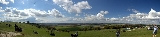
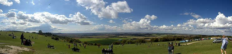
Dunstable Downs are part of the Chiltern Hills
, in southern Bedfordshire
in England
. They are a chalk
escarpment
forming the north-eastern reaches of the Chilterns. At 243 m (797 ft), Dunstable Downs are the highest point of the county
of Bedfordshire.
Because of its elevation, Dunstable Downs hosted a station in the shutter telegraph chain which connected the Admiralty
in London
to its naval ships in the port of Great Yarmouth
during the years 1808 to 1814.
Whipsnade Zoo has cut an enormous lion shape into the chalk
into the side of one of the hills. The lion can be seen from the B489 (Aylesbury
to Dunstable
road).
The downs are used by gliders
, kite
fliers, hang gliders
and paragliders
in the area because of their height. The London Gliding Club
is based at the foot of the downs.
Much of the downs are managed by the National Trust
as part of the Dunstable Downs, Countryside Centre & Whipsnade Estate property.
and the National Trust commissioned Architype architects to build a visitor centre known as The Chilterns Gateway Centre, on the very top of Dunstable Downs. The summit is right next to the B4541 road that crosses the hill, and so an ascent of the hill requires nothing more than getting out of a car at the highest point and walking across to the trig point
.
For those who wish to climb the hill from the base, it is possible to do a circular walk from the village of Whipsnade
by following the Icknield Way Path
and Chiltern Way
, both of which are marked on Ordnance Survey
maps. This circuit can be extended to take in the northern top of Five Knolls. The hill can also be ascended from Dunstable
to the north.
The Icknield Way Trail, a horse rider and off-road cycle route, has been established following a similar route to the Icknield Way Path
which passes over the Dunstable Downs.
, and different butterfly species, like the Marbled White and the Chalkhill Blue
.
Areas of the west-facing slope were notified in 1987 under the Wildlife and Countryside Act 1981
as a Site of Special Scientific Interest
(SSSI) called Dunstable and Whipsnade Downs. This includes parts of Whipsnade Zoo.
is sometimes omitted.
The area is designated an SSSI
, most of which is managed as a nature reserve
by the Wildlife Trust for Bedfordshire, Cambridgeshire, Northamptonshire and Peterborough
.
Chiltern Hills
The Chiltern Hills form a chalk escarpment in South East England. They are known locally as "the Chilterns". A large portion of the hills was designated officially as an Area of Outstanding Natural Beauty in 1965.-Location:...
, in southern Bedfordshire
Bedfordshire
Bedfordshire is a ceremonial county of historic origin in England that forms part of the East of England region.It borders Cambridgeshire to the north-east, Northamptonshire to the north, Buckinghamshire to the west and Hertfordshire to the south-east....
in England
England
England is a country that is part of the United Kingdom. It shares land borders with Scotland to the north and Wales to the west; the Irish Sea is to the north west, the Celtic Sea to the south west, with the North Sea to the east and the English Channel to the south separating it from continental...
. They are a chalk
Chalk
Chalk is a soft, white, porous sedimentary rock, a form of limestone composed of the mineral calcite. Calcite is calcium carbonate or CaCO3. It forms under reasonably deep marine conditions from the gradual accumulation of minute calcite plates shed from micro-organisms called coccolithophores....
escarpment
Escarpment
An escarpment is a steep slope or long cliff that occurs from erosion or faulting and separates two relatively level areas of differing elevations.-Description and variants:...
forming the north-eastern reaches of the Chilterns. At 243 m (797 ft), Dunstable Downs are the highest point of the county
County
A county is a jurisdiction of local government in certain modern nations. Historically in mainland Europe, the original French term, comté, and its equivalents in other languages denoted a jurisdiction under the sovereignty of a count A county is a jurisdiction of local government in certain...
of Bedfordshire.
Because of its elevation, Dunstable Downs hosted a station in the shutter telegraph chain which connected the Admiralty
Admiralty
The Admiralty was formerly the authority in the Kingdom of England, and later in the United Kingdom, responsible for the command of the Royal Navy...
in London
London
London is the capital city of :England and the :United Kingdom, the largest metropolitan area in the United Kingdom, and the largest urban zone in the European Union by most measures. Located on the River Thames, London has been a major settlement for two millennia, its history going back to its...
to its naval ships in the port of Great Yarmouth
Great Yarmouth
Great Yarmouth, often known to locals as Yarmouth, is a coastal town in Norfolk, England. It is at the mouth of the River Yare, east of Norwich.It has been a seaside resort since 1760, and is the gateway from the Norfolk Broads to the sea...
during the years 1808 to 1814.
Whipsnade Zoo has cut an enormous lion shape into the chalk
Hill figure
A hill figure is a large visual representation created by cutting into a steep hillside and revealing the underlying geology. It is a type of geoglyph usually designed to be seen from afar rather than above. In some cases trenches are dug and rubble made from material brighter than the natural...
into the side of one of the hills. The lion can be seen from the B489 (Aylesbury
Aylesbury
Aylesbury is the county town of Buckinghamshire in South East England. However the town also falls into a geographical region known as the South Midlands an area that ecompasses the north of the South East, and the southern extremities of the East Midlands...
to Dunstable
Dunstable
Dunstable is a market town and civil parish located in Bedfordshire, England. It lies on the eastward tail spurs of the Chiltern Hills, 30 miles north of London. These geographical features form several steep chalk escarpments most noticeable when approaching Dunstable from the north.-Etymology:In...
road).
The downs are used by gliders
Glider (sailplane)
A glider or sailplane is a type of glider aircraft used in the sport of gliding. Some gliders, known as motor gliders are used for gliding and soaring as well, but have engines which can, in some cases, be used for take-off or for extending a flight...
, kite
Kite
A kite is a tethered aircraft. The necessary lift that makes the kite wing fly is generated when air flows over and under the kite's wing, producing low pressure above the wing and high pressure below it. This deflection also generates horizontal drag along the direction of the wind...
fliers, hang gliders
Hang gliding
Hang gliding is an air sport in which a pilot flies a light and unmotorized foot-launchable aircraft called a hang glider ....
and paragliders
Paragliding
Paragliding is the recreational and competitive adventure sport of flying paragliders: lightweight, free-flying, foot-launched glider aircraft with no rigid primary structure...
in the area because of their height. The London Gliding Club
London Gliding Club
The London Gliding Club is a private members' club, and was set up primarily to train pilots in powerless flight, and the skills necessary to fly cross country using nature's sources of energy. Aerobatics and instructor training is also available. The club provides gliding courses, one day courses...
is based at the foot of the downs.
Much of the downs are managed by the National Trust
National Trust for Places of Historic Interest or Natural Beauty
The National Trust for Places of Historic Interest or Natural Beauty, usually known as the National Trust, is a conservation organisation in England, Wales and Northern Ireland...
as part of the Dunstable Downs, Countryside Centre & Whipsnade Estate property.
Ascents
Central Bedfordshire CouncilCentral Bedfordshire
Central Bedfordshire is a unitary authority in the ceremonial county of Bedfordshire, England. It was created from the merger of Bedfordshire County Council, Mid Bedfordshire and South Bedfordshire on 1 April 2009...
and the National Trust commissioned Architype architects to build a visitor centre known as The Chilterns Gateway Centre, on the very top of Dunstable Downs. The summit is right next to the B4541 road that crosses the hill, and so an ascent of the hill requires nothing more than getting out of a car at the highest point and walking across to the trig point
Trig point
A triangulation station, also known as a triangulation pillar, trigonometrical station, trigonometrical point, trig station, trig beacon or trig point, and sometimes informally as a trig, is a fixed surveying station, used in geodetic surveying and other surveying projects in its vicinity...
.
For those who wish to climb the hill from the base, it is possible to do a circular walk from the village of Whipsnade
Whipsnade
Whipsnade is a small village and civil parish in the county of Bedfordshire. It lies on the eastward tail spurs of the Chiltern Hills, about 2.5 miles South-South-West of Dunstable...
by following the Icknield Way Path
Icknield Way Path
Icknield Way Path is a long distance footpath in East Anglia, England.It connects with: Angles Way, , Chiltern Way, , Hertfordshire Chain Walk, Hertfordshire Way, Lea Valley Walk, Peddars Way, Ridgeway, Roman Road Link, Stour Valley Path and Swan's Way....
and Chiltern Way
Chiltern Way
The Chiltern Way is a waymarked long-distance footpath in southern England in the United Kingdom.-The route:The route is circular and runs through the Chiltern Hills region passing through parts of the counties of Bedfordshire, Buckinghamshire, Hertfordshire and Oxfordshire.The meandering route...
, both of which are marked on Ordnance Survey
Ordnance Survey
Ordnance Survey , an executive agency and non-ministerial government department of the Government of the United Kingdom, is the national mapping agency for Great Britain, producing maps of Great Britain , and one of the world's largest producers of maps.The name reflects its creation together with...
maps. This circuit can be extended to take in the northern top of Five Knolls. The hill can also be ascended from Dunstable
Dunstable
Dunstable is a market town and civil parish located in Bedfordshire, England. It lies on the eastward tail spurs of the Chiltern Hills, 30 miles north of London. These geographical features form several steep chalk escarpments most noticeable when approaching Dunstable from the north.-Etymology:In...
to the north.
The Icknield Way Trail, a horse rider and off-road cycle route, has been established following a similar route to the Icknield Way Path
Icknield Way Path
Icknield Way Path is a long distance footpath in East Anglia, England.It connects with: Angles Way, , Chiltern Way, , Hertfordshire Chain Walk, Hertfordshire Way, Lea Valley Walk, Peddars Way, Ridgeway, Roman Road Link, Stour Valley Path and Swan's Way....
which passes over the Dunstable Downs.
Natural history
The downs are home to a wide variety of wildlife including many rare wild flowers, such as the Bee OrchidBee Orchid
The Bee Orchid is an herbaceous perennial plant belonging to the family Orchidaceae.-Etymology:The name "Ophrys" derives from the Greek word "ophrys", meaning "eyebrow", while the Latin name of the species "apifera" refers to the bee-shaped lip.-Description: The Bee Orchid grows to a height of ....
, and different butterfly species, like the Marbled White and the Chalkhill Blue
Chalkhill Blue
The Chalkhill Blue is a butterfly in the family Lycaenidae.Males have pale silvery-blue wings with black and white border . Females are dark brown, also with the black and white borders...
.
Areas of the west-facing slope were notified in 1987 under the Wildlife and Countryside Act 1981
Wildlife and Countryside Act 1981
The Wildlife and Countryside Act 1981 is an Act of Parliament in the United Kingdom and was implemented to comply with the Directive 2009/147/EC on the conservation of wild birds...
as a Site of Special Scientific Interest
Site of Special Scientific Interest
A Site of Special Scientific Interest is a conservation designation denoting a protected area in the United Kingdom. SSSIs are the basic building block of site-based nature conservation legislation and most other legal nature/geological conservation designations in Great Britain are based upon...
(SSSI) called Dunstable and Whipsnade Downs. This includes parts of Whipsnade Zoo.
Blow's Downs
Blow's Downs (51.8819°N 0.5012°W) are a continuation of the Dunstable Downs escarpment on the eastern side of Dunstable. This is also known as Blow's Down, and the apostropheApostrophe
The apostrophe is a punctuation mark, and sometimes a diacritic mark, in languages that use the Latin alphabet or certain other alphabets...
is sometimes omitted.
The area is designated an SSSI
Site of Special Scientific Interest
A Site of Special Scientific Interest is a conservation designation denoting a protected area in the United Kingdom. SSSIs are the basic building block of site-based nature conservation legislation and most other legal nature/geological conservation designations in Great Britain are based upon...
, most of which is managed as a nature reserve
Nature reserve
A nature reserve is a protected area of importance for wildlife, flora, fauna or features of geological or other special interest, which is reserved and managed for conservation and to provide special opportunities for study or research...
by the Wildlife Trust for Bedfordshire, Cambridgeshire, Northamptonshire and Peterborough
Wildlife Trust for Bedfordshire, Cambridgeshire, Northamptonshire and Peterborough
The Wildlife Trust for Bedfordshire, Cambridgeshire, Northamptonshire and Peterborough is a wildlife trust covering the counties of Bedfordshire, Cambridgeshire, Northamptonshire and the City of Peterborough in England....
.
External links
- Dunstable Downs, Countryside Centre & Whipsnade Estate at the National Trust
- The lion is very clear on
- London Gliding Club