
Interstate 95 in Massachusetts
Encyclopedia
Interstate 95 is the main highway
on the East Coast of the United States
, paralleling the Atlantic Ocean
from Florida
to Maine
. The Massachusetts
portion of the highway enters from the state of Rhode Island
in Attleboro
and travels in a northeasterly direction to the junction with Route 128
in Canton
. As the original plans for I-95 (which would have taken it through downtown Boston
) were canceled, the highway follows the Route 128 loop around the Greater Boston
area to Peabody
. From there, I-95 splits from Route 128 and turns north towards the Merrimack River
. I-95 enters New Hampshire
from Salisbury
.
into Attleboro
as a six-lane highway, with the first northbound exits, 2A and 2B, providing access to Route 1A
and nearby U.S. Route 1
near the border. (There is an Exit 1, but it is a southbound-only exit connecting to US-1 south into Rhode Island.) Exits 3-5 also serve the Attleboro area, with Exit 4 at the northern terminus of Interstate 295.
Exits 6A and 6B in Mansfield
provide access to Interstate 495
, the "outer circumferential" beltway around metro Boston. I-495 provides northbound connections to Worcester
, the Massachusetts Turnpike
, and the western part of the state, and southbound connections to Cape Cod
. Mansfield is home to the Comcast Center, a Live Nation
-owned amphitheatre
which hosts numerous concert events, and the TPC Boston, a PGA
player's club that hosts the Deutsche Bank Championship
yearly. The two venues are located near I-95's interchanges with Route 140
.
I-95 continues northward into Foxborough
, home of Gillette Stadium
, located on US-1 and accessible from Exit 9. The interstate continues through Sharon
, Walpole
, and Norwood
, before entering Canton
, where it meets Interstate 93
at its southern terminus (Exit 12).
begins here as well. The highway enters Westwood
next, with US-1 leaving the freeway near the Dedham
town line (at Exit 15B) to parallel I-95 back to the south. I-95 and Route 128 begin to make their way around metro Boston, passing through Dedham, Needham
, and Wellesley
, where the freeway interchanges with Route 9
at Exit 20, and the freeway widens to eight lanes. About three miles north, I-95/Route 128 enter Weston
and interchange with the Massachusetts Turnpike
(I-90, at Exit 25) in a large interchange which provides connections to nearby Route 30. Exits 23, 24, and 25 are one combined exit northbound.
I-95 and Route 128 are due west of the city at this point and begin to turn to the northeast, serving the city of Waltham
and the town of Lexington
along the way. The freeway interchanges with Route 2 (Concord Turnpike) at Exit 29. Upon entering the town of Burlington
, I-95 and Route 128 interchange with U.S. Route 3
, the Northwestern Expressway, at Exit 32A. US-3 provides a direct freeway connection with the Lowell
and Nashua, NH metro areas. Access to the Middlesex Turnpike and Burlington retail district is facilitated at this interchange as well. US-3 south briefly joins the freeway in another wrong-way multiplex in order to connect with its old alignment, leaving at Exit 33A. I-95 and Route 128 continue northeast through the city of Woburn
and into Reading
.
In Reading, I-95 and Route 128 once again interchange with I-93. After crossing, I-93, the now six-lane highway continues to the northeast, serving the towns of Wakefield
and Lynnfield
before crossing into Peabody
, where Route 128 leaves I-95 at Exit 45 as its own freeway towards Gloucester
. At this interchange, six lanes of through traffic are designated for Route 128 while four lanes split off as I-95.
, Boxford
, Georgetown
, Rowley
, Newbury
, West Newbury
, Newburyport
, Amesbury
, and Salisbury
. Traffic density is generally low on this 25 miles (40.2 km) stretch of freeway. After Exit 57, the highway narrows to six lanes until the I-495 interchange expands it back to eight lanes.
I-495 has its northern terminus at I-95 Exit 59 just south of the New Hampshire
state line, a Y-interchange that merges I-495 onto I-95. Southbound access is possible via Exit 58 for Route 110 westbound, which leads to I-495's Exit 55 (I-495's last exit before I-95). The northernmost exit in Massachusetts is Exit 60, providing access to Main Street towards Amesbury and Route 286 towards Salisbury Beach and Hampton Beach
(the southbound ramp starts in New Hampshire). After crossing underneath the connecting roads, I-95 crosses the state line into Seabrook, New Hampshire
.
. The highway would have progressed from Route 128 and Readville
, followed the Southwest Corridor, joined the Inner Belt in Roxbury, heading east, and joining the Southeast Expressway at South Bay, then north to the Central Artery
at the South Station
interchange with the Massachusetts Turnpike
/Interstate 90
, and connecting with the Northeast Expressway
at the Charlestown banks of the Charles River
.
However, due to pressure from local residents, all proposed Interstate Highways within Route 128
were canceled in 1972 by Governor Francis Sargent with the exception of Interstate 93
to Boston. The only sections of I-95 completed within the Route 128 beltway by the Massachusetts Department of Transportation were the segment known as the Northeast Expressway
north from Charlestown to Saugus
, which is now part of U.S. 1
, and the Central Artery, which cut the North End neighborhood from downtown Boston proper. The Southwest Expressway and the Inner Belt highways were among the Sargent-canceled highways.
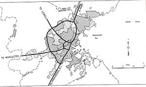 Between 1972 and 1974, plans were to extend I-95 along a northerly extension of the Northeast Expressway to Route 128 in northwestern Danvers
. During this time, I-95 was officially routed along Route 128 from Canton
to Braintree
and north along the Southeast Expressway (also designated Route 3
), from Braintree to Boston, then following the Central Artery, and continuing along the Northeast Expressway in Boston, Chelsea and Revere.
When the Northeast Expressway extension (between Saugus and Danvers) was canceled in 1974, I-95's route shifted to its current routing along the perimeter highway, Route 128, and I-93 was extended to meet I-95 in Canton. Plans for the abandoned roadways can still be seen going from the end of the Northeast Expressway to the Saugus River
in Saugus
. Along the unbuilt alignment from Saugus to Route 128, one can see unused bridges, ghost ramps, and graded—but unpaved—roadbed that was originally intended to carry I-95.
Highway
A highway is any public road. In American English, the term is common and almost always designates major roads. In British English, the term designates any road open to the public. Any interconnected set of highways can be variously referred to as a "highway system", a "highway network", or a...
on the East Coast of the United States
East Coast of the United States
The East Coast of the United States, also known as the Eastern Seaboard, refers to the easternmost coastal states in the United States, which touch the Atlantic Ocean and stretch up to Canada. The term includes the U.S...
, paralleling the Atlantic Ocean
Atlantic Ocean
The Atlantic Ocean is the second-largest of the world's oceanic divisions. With a total area of about , it covers approximately 20% of the Earth's surface and about 26% of its water surface area...
from Florida
Florida
Florida is a state in the southeastern United States, located on the nation's Atlantic and Gulf coasts. It is bordered to the west by the Gulf of Mexico, to the north by Alabama and Georgia and to the east by the Atlantic Ocean. With a population of 18,801,310 as measured by the 2010 census, it...
to Maine
Maine
Maine is a state in the New England region of the northeastern United States, bordered by the Atlantic Ocean to the east and south, New Hampshire to the west, and the Canadian provinces of Quebec to the northwest and New Brunswick to the northeast. Maine is both the northernmost and easternmost...
. The Massachusetts
Massachusetts
The Commonwealth of Massachusetts is a state in the New England region of the northeastern United States of America. It is bordered by Rhode Island and Connecticut to the south, New York to the west, and Vermont and New Hampshire to the north; at its east lies the Atlantic Ocean. As of the 2010...
portion of the highway enters from the state of Rhode Island
Rhode Island
The state of Rhode Island and Providence Plantations, more commonly referred to as Rhode Island , is a state in the New England region of the United States. It is the smallest U.S. state by area...
in Attleboro
Attleboro, Massachusetts
Attleboro is a city in Bristol County, Massachusetts, United States and is immediately north of Pawtucket, Rhode Island. Once known as "The Jewelry Capital of the World" for its many jewelry manufacturers, Attleboro had a population of 42,068 at the 2000 census, and a population of 43,645 as of...
and travels in a northeasterly direction to the junction with Route 128
Route 128 (Massachusetts)
Route 128, also known as the Yankee Division Highway , and originally the Circumferential Highway, is a partial beltway around Boston, Massachusetts, United States. The majority of the highway is built to freeway standards, and about 3/5 of it is part of the Interstate Highway System...
in Canton
Canton, Massachusetts
Canton is a town in Norfolk County, Massachusetts, United States. The population was 21,561 at the 2010 census. Canton is part of Greater Boston, about 15 miles southwest of downtown Boston.- History :...
. As the original plans for I-95 (which would have taken it through downtown Boston
Boston
Boston is the capital of and largest city in Massachusetts, and is one of the oldest cities in the United States. The largest city in New England, Boston is regarded as the unofficial "Capital of New England" for its economic and cultural impact on the entire New England region. The city proper had...
) were canceled, the highway follows the Route 128 loop around the Greater Boston
Greater Boston
Greater Boston is the area of the Commonwealth of Massachusetts surrounding the city of Boston. Due to ambiguity in usage, the size of the area referred to can be anywhere between that of the metropolitan statistical area of Boston and that of the city's combined statistical area which includes...
area to Peabody
Peabody, Massachusetts
Peabody is a city in Essex County, Massachusetts, United States. The population is about 53,000. Peabody is located in Boston's North Shore suburban area.- History :...
. From there, I-95 splits from Route 128 and turns north towards the Merrimack River
Merrimack River
The Merrimack River is a river in the northeastern United States. It rises at the confluence of the Pemigewasset and Winnipesaukee rivers in Franklin, New Hampshire, flows southward into Massachusetts, and then flows northeast until it empties into the Atlantic Ocean at Newburyport...
. I-95 enters New Hampshire
New Hampshire
New Hampshire is a state in the New England region of the northeastern United States of America. The state was named after the southern English county of Hampshire. It is bordered by Massachusetts to the south, Vermont to the west, Maine and the Atlantic Ocean to the east, and the Canadian...
from Salisbury
Salisbury, Massachusetts
Salisbury is a town in Essex County, Massachusetts, United States. The population was 7,827 at the 2000 census. The community is a popular summer resort beach town situated on the Atlantic Ocean north of Boston on the New Hampshire border....
.
Attleboro to Canton
I-95 crosses the state border from Pawtucket, Rhode IslandPawtucket, Rhode Island
Pawtucket is a city in Providence County, Rhode Island, United States. The population was 71,148 at the 2010 census. It is the fourth largest city in the state.-History:...
into Attleboro
Attleboro, Massachusetts
Attleboro is a city in Bristol County, Massachusetts, United States and is immediately north of Pawtucket, Rhode Island. Once known as "The Jewelry Capital of the World" for its many jewelry manufacturers, Attleboro had a population of 42,068 at the 2000 census, and a population of 43,645 as of...
as a six-lane highway, with the first northbound exits, 2A and 2B, providing access to Route 1A
Route 1A (Massachusetts)
Route 1A is a south–north state highway in Massachusetts. It is an alternate route to U.S. 1 with three signed sections and two unsigned sections where the highway is concurrent with its parent...
and nearby U.S. Route 1
U.S. Route 1 in Massachusetts
In the U.S. state of Massachusetts, U.S. Route 1 is a major north–south state highway through Boston. The portion of US 1 south of Boston is also known as the Boston-Providence Turnpike, and portions north of the city are known as the Northeast Expressway and the Newburyport Turnpike.-Route...
near the border. (There is an Exit 1, but it is a southbound-only exit connecting to US-1 south into Rhode Island.) Exits 3-5 also serve the Attleboro area, with Exit 4 at the northern terminus of Interstate 295.
Exits 6A and 6B in Mansfield
Mansfield, Massachusetts
Mansfield is a town in Bristol County, Massachusetts, United States. As of the United States 2010 Census, the town population is 23,184. Mansfield is in the south-southwest suburbs of Boston and is also close to Providence, Rhode Island....
provide access to Interstate 495
Interstate 495 (Massachusetts)
Interstate 495 is the designation of an Interstate Highway half-beltway in Massachusetts. It was the longest auxiliary Interstate Highway of its kind—measuring 120.74 miles —until 1996, when the PA Route 9 section of the Pennsylvania Turnpike was redesignated as Interstate 476, making it about ...
, the "outer circumferential" beltway around metro Boston. I-495 provides northbound connections to Worcester
Worcester, Massachusetts
Worcester is a city and the county seat of Worcester County, Massachusetts, United States. Named after Worcester, England, as of the 2010 Census the city's population is 181,045, making it the second largest city in New England after Boston....
, the Massachusetts Turnpike
Massachusetts Turnpike
The Massachusetts Turnpike is the easternmost stretch of Interstate 90. The Turnpike begins at the western border of Massachusetts in West Stockbridge connecting with the Berkshire Connector portion of the New York State Thruway...
, and the western part of the state, and southbound connections to Cape Cod
Cape Cod
Cape Cod, often referred to locally as simply the Cape, is a cape in the easternmost portion of the state of Massachusetts, in the Northeastern United States...
. Mansfield is home to the Comcast Center, a Live Nation
Live Nation
Live Nation is a live-events company based in Beverly Hills, California, focused on concert promotions. Live Nation formed in 2005 as a spin-off from Clear Channel Communications, which then merged with Ticketmaster in 2010 to become Live Nation Entertainment....
-owned amphitheatre
Amphitheatre
An amphitheatre is an open-air venue used for entertainment and performances.There are two similar, but distinct, types of structure for which the word "amphitheatre" is used: Ancient Roman amphitheatres were large central performance spaces surrounded by ascending seating, and were commonly used...
which hosts numerous concert events, and the TPC Boston, a PGA
PGA Tour
The PGA Tour is the organizer of the main men's professional golf tours in the United States and North America...
player's club that hosts the Deutsche Bank Championship
Deutsche Bank Championship
The Deutsche Bank Championship is a professional golf tournament on the PGA Tour, held annually over the Labor Day weekend. The tournament made its debut in 2003 and is held at the Tournament Players Club of Boston in Norton, Massachusetts...
yearly. The two venues are located near I-95's interchanges with Route 140
Route 140 (Massachusetts)
Route 140 is a long state highway which passes through parts of southeastern and central Massachusetts. The highway follows a southeast-northwest trajectory, running from U.S...
.
I-95 continues northward into Foxborough
Foxborough, Massachusetts
-Demographics:As of the census of 2000, there were 16,246 people, 6,141 households, and 4,396 families residing in the town. The population density was 809.1 people per square mile . There were 6,299 housing units at an average density of 313.7 per square mile...
, home of Gillette Stadium
Gillette Stadium
Gillette Stadium is a multi-purpose stadium located in Foxborough, Massachusetts, 21 miles southwest of downtown Boston and from downtown Providence, Rhode Island. It serves as the home stadium and administrative offices for the New England Patriots football team and the New England Revolution...
, located on US-1 and accessible from Exit 9. The interstate continues through Sharon
Sharon, Massachusetts
Sharon is a town in Norfolk County, Massachusetts, United States. The population was 17,612 at the 2010 census. Sharon is part of Greater Boston, about 17 miles southwest of downtown Boston....
, Walpole
Walpole, Massachusetts
Walpole is a town in Norfolk County, Massachusetts, United States. It is located about south of Boston and north of Providence, Rhode Island. The population was 24,070 at the 2010 census. Walpole was first settled in 1659 and was considered a part of Dedham until officially incorporated in 1724...
, and Norwood
Norwood, Massachusetts
Norwood is a town and census-designated place in Norfolk County, Massachusetts, United States. As of the 2010 census, the population was 28,602. The community was named after Norwood, England...
, before entering Canton
Canton, Massachusetts
Canton is a town in Norfolk County, Massachusetts, United States. The population was 21,561 at the 2010 census. Canton is part of Greater Boston, about 15 miles southwest of downtown Boston.- History :...
, where it meets Interstate 93
Interstate 93
Interstate 93 is an Interstate Highway in the New England section of the United States. Its southern terminus is in Canton, Massachusetts, in the Boston metropolitan area, at Interstate 95; its northern terminus is near St. Johnsbury, Vermont, at Interstate 91...
at its southern terminus (Exit 12).
Canton to Peabody (Route 128)
Upon interchanging with I-93, I-95 loops around to the west, taking over the roadbed from I-93 and joining US-1 southbound in a wrong-way concurrency. Route 128Route 128 (Massachusetts)
Route 128, also known as the Yankee Division Highway , and originally the Circumferential Highway, is a partial beltway around Boston, Massachusetts, United States. The majority of the highway is built to freeway standards, and about 3/5 of it is part of the Interstate Highway System...
begins here as well. The highway enters Westwood
Westwood, Massachusetts
Westwood is a town in Norfolk County, Massachusetts, United States. The population was 14,618 at the 2010 census. In July 2005, CNN/Money and Money magazine ranked Westwood 13th on its list of the 100 Best Places to Live in the United States. Boston Magazine listed Gay Street in Westwood on its...
next, with US-1 leaving the freeway near the Dedham
Dedham, Massachusetts
Dedham is a town in and the county seat of Norfolk County, Massachusetts, United States. The population was 24,729 at the 2010 census. It is located on Boston's southwest border. On the northwest it is bordered by Needham, on the southwest by Westwood and on the southeast by...
town line (at Exit 15B) to parallel I-95 back to the south. I-95 and Route 128 begin to make their way around metro Boston, passing through Dedham, Needham
Needham, Massachusetts
Needham is a town in Norfolk County, Massachusetts, United States. A suburb of Boston, its population was 28,886 at the 2010 census.- History :...
, and Wellesley
Wellesley, Massachusetts
Wellesley is a town in Norfolk County, Massachusetts, United States. It is part of Greater Boston. The population was 27,982 at the time of the 2010 census.It is best known as the home of Wellesley College and Babson College...
, where the freeway interchanges with Route 9
Route 9 (Massachusetts)
Route 9 is a major east–west state highway in Massachusetts. Along with U.S. Route 20, Route 2 and the Massachusetts Turnpike, Route 9 is one of the major east-west routes of Massachusetts, and like the others its eastern terminus is in Boston...
at Exit 20, and the freeway widens to eight lanes. About three miles north, I-95/Route 128 enter Weston
Weston, Massachusetts
Weston is a suburb of Boston located in Middlesex County, Massachusetts, United States in the Boston metro area. The population of Weston, according to the 2010 U.S. Census, is 11,261....
and interchange with the Massachusetts Turnpike
Massachusetts Turnpike
The Massachusetts Turnpike is the easternmost stretch of Interstate 90. The Turnpike begins at the western border of Massachusetts in West Stockbridge connecting with the Berkshire Connector portion of the New York State Thruway...
(I-90, at Exit 25) in a large interchange which provides connections to nearby Route 30. Exits 23, 24, and 25 are one combined exit northbound.
I-95 and Route 128 are due west of the city at this point and begin to turn to the northeast, serving the city of Waltham
Waltham, Massachusetts
Waltham is a city in Middlesex County, Massachusetts, United States, was an early center for the labor movement, and major contributor to the American Industrial Revolution. The original home of the Boston Manufacturing Company, the city was a prototype for 19th century industrial city planning,...
and the town of Lexington
Lexington, Massachusetts
Lexington is a town in Middlesex County, Massachusetts, United States. The population was 31,399 at the 2010 census. This town is famous for being the site of the first shot of the American Revolution, in the Battle of Lexington on April 19, 1775.- History :...
along the way. The freeway interchanges with Route 2 (Concord Turnpike) at Exit 29. Upon entering the town of Burlington
Burlington, Massachusetts
Burlington is a town in Middlesex County, Massachusetts, United States. The population was 24,498 at the 2010 census.- History :It is believed that Burlington takes its name from the English town of Bridlington, however this has never been confirmed....
, I-95 and Route 128 interchange with U.S. Route 3
U.S. Route 3
U.S. Route 3 is a north–south United States highway that runs from its southern terminus in Cambridge, Massachusetts through New Hampshire to its terminus near Third Connecticut Lake at the Canadian border, where the road continues north as Quebec Route 257.In New Hampshire parts of US 3 are...
, the Northwestern Expressway, at Exit 32A. US-3 provides a direct freeway connection with the Lowell
Lowell, Massachusetts
Lowell is a city in Middlesex County, Massachusetts, USA. According to the 2010 census, the city's population was 106,519. It is the fourth largest city in the state. Lowell and Cambridge are the county seats of Middlesex County...
and Nashua, NH metro areas. Access to the Middlesex Turnpike and Burlington retail district is facilitated at this interchange as well. US-3 south briefly joins the freeway in another wrong-way multiplex in order to connect with its old alignment, leaving at Exit 33A. I-95 and Route 128 continue northeast through the city of Woburn
Woburn, Massachusetts
Woburn is a city in Middlesex County, Massachusetts, USA. The population was 38,120 at the 2010 census. Woburn is located north of Boston, Massachusetts, and just south of the intersection of I-93 and I-95.- History :...
and into Reading
Reading, Massachusetts
Reading is an affluent town situated in Middlesex County, Massachusetts, United States, some north of central Boston. The population was 24,747 at the 2010 census.-Settlement and Independence:...
.
In Reading, I-95 and Route 128 once again interchange with I-93. After crossing, I-93, the now six-lane highway continues to the northeast, serving the towns of Wakefield
Wakefield, Massachusetts
-History:-Geography:The diagram above shows what is to the east, west, north, south, and other directions of the center of Wakefield. Towns with population above 25,000 are in bold italics.-Demographics:-Notable residents:...
and Lynnfield
Lynnfield, Massachusetts
Lynnfield is a wealthy town in Essex County, Massachusetts, in the United States. As of the 2000 census, the town population was 11,542.- History :...
before crossing into Peabody
Peabody, Massachusetts
Peabody is a city in Essex County, Massachusetts, United States. The population is about 53,000. Peabody is located in Boston's North Shore suburban area.- History :...
, where Route 128 leaves I-95 at Exit 45 as its own freeway towards Gloucester
Gloucester, Massachusetts
Gloucester is a city on Cape Ann in Essex County, Massachusetts, in the United States. It is part of Massachusetts' North Shore. The population was 28,789 at the 2010 U.S. Census...
. At this interchange, six lanes of through traffic are designated for Route 128 while four lanes split off as I-95.
Peabody to Salisbury
After leaving Route 128, I-95 expands to eight lanes and heads north through the less densely populated northeastern portion of the state. The freeway serves the communities of DanversDanvers, Massachusetts
Danvers is a town in Essex County, Massachusetts, United States. Located on the Danvers River near the northeastern coast of Massachusetts, Danvers is most widely known for its association with the 1692 Salem witch trials, and for its famous asylum, the Danvers State Hospital.-17th century:The land...
, Boxford
Boxford, Massachusetts
Boxford is a town in Essex County, Massachusetts, United States. The population was 7,965 at the 2010 census.Part of the town comprises the census-designated place of Boxford.-Geography:...
, Georgetown
Georgetown, Massachusetts
Georgetown is a town in Essex County, Massachusetts, United States. The population was 8,183 at the 2010 census. It was incorporated in 1838 from part of Rowley.-History:...
, Rowley
Rowley, Massachusetts
Rowley is a town in Essex County, Massachusetts, United States. The population was 5,500 at the 2000 census.Part of the town comprises the census-designated place of Rowley.-History:...
, Newbury
Newbury, Massachusetts
Newbury is a town in Essex County, Massachusetts, United States. The population was 6,666 at the 2010 census. Newbury includes the villages of Old Town , Plum Island and Byfield, home of The Governor's Academy , a private preparatory school.- History :Newbury Plantation was settled and incorporated...
, West Newbury
West Newbury, Massachusetts
West Newbury is a town in Essex County, Massachusetts, United States. Situated on the Merrimack River, its population was 4,450 at the 2006 census. Along with neighboring Merrimac and Groveland, it is part of the Pentucket Regional School District....
, Newburyport
Newburyport, Massachusetts
Newburyport is a small coastal city in Essex County, Massachusetts, United States, 35 miles northeast of Boston. The population was 21,189 at the 2000 census. A historic seaport with a vibrant tourism industry, Newburyport includes part of Plum Island...
, Amesbury
Amesbury, Massachusetts
Amesbury is a city in Essex County, Massachusetts, United States. Though it officially became a city in 1996, its formal name remains "The Town of Amesbury." In 1890, 9798 people lived in Amesbury; in 1900, 9473; in 1910, 9894; in 1920, 10,036; and in 1940, 10,862. The population was 16,283 at...
, and Salisbury
Salisbury, Massachusetts
Salisbury is a town in Essex County, Massachusetts, United States. The population was 7,827 at the 2000 census. The community is a popular summer resort beach town situated on the Atlantic Ocean north of Boston on the New Hampshire border....
. Traffic density is generally low on this 25 miles (40.2 km) stretch of freeway. After Exit 57, the highway narrows to six lanes until the I-495 interchange expands it back to eight lanes.
I-495 has its northern terminus at I-95 Exit 59 just south of the New Hampshire
New Hampshire
New Hampshire is a state in the New England region of the northeastern United States of America. The state was named after the southern English county of Hampshire. It is bordered by Massachusetts to the south, Vermont to the west, Maine and the Atlantic Ocean to the east, and the Canadian...
state line, a Y-interchange that merges I-495 onto I-95. Southbound access is possible via Exit 58 for Route 110 westbound, which leads to I-495's Exit 55 (I-495's last exit before I-95). The northernmost exit in Massachusetts is Exit 60, providing access to Main Street towards Amesbury and Route 286 towards Salisbury Beach and Hampton Beach
Hampton Beach, New Hampshire
Hampton Beach is a village district, census-designated place, and beach resort within the town of Hampton, in the U.S. state of New Hampshire, located on the Atlantic Ocean. Its population at the 2010 census was 2,275. Hampton Beach is located in Rockingham County, approximately south of Portsmouth...
(the southbound ramp starts in New Hampshire). After crossing underneath the connecting roads, I-95 crosses the state line into Seabrook, New Hampshire
Seabrook, New Hampshire
Seabrook is a town in Rockingham County, New Hampshire, United States. The population was 8,693 at the 2010 census. Located at the southern end of the coast of New Hampshire on the border with Massachusetts, Seabrook is noted as the location of the Seabrook Nuclear Power Station, the third-most...
.
History
The original plans called for I-95 to run through downtown BostonBoston
Boston is the capital of and largest city in Massachusetts, and is one of the oldest cities in the United States. The largest city in New England, Boston is regarded as the unofficial "Capital of New England" for its economic and cultural impact on the entire New England region. The city proper had...
. The highway would have progressed from Route 128 and Readville
Readville, Massachusetts
Readville, called Low Plains from 1655 until renaming in 1847 after Mr. James Read originally part of Dedham until 1867 but now a part of Boston, is considered either a part of the Hyde Park neighborhood, or a neighborhood in its own right. It is served by Readville station on the MBTA Commuter Rail...
, followed the Southwest Corridor, joined the Inner Belt in Roxbury, heading east, and joining the Southeast Expressway at South Bay, then north to the Central Artery
Central Artery
The John F. Fitzgerald Expressway, known locally as the Central Artery, is a section of freeway in downtown Boston, Massachusetts, designated as Interstate 93, U.S. Route 1 and Route 3. It was initially constructed in the 1950s as a partly elevated and partly tunneled divided highway...
at the South Station
South Station
South Station, New England's second-largest transportation center , located at the intersection of Atlantic Avenue and Summer Street in Dewey Square, Boston, Massachusetts, is the largest train station and intercity bus terminal in Greater Boston, a prominent train station in the northeastern...
interchange with the Massachusetts Turnpike
Massachusetts Turnpike
The Massachusetts Turnpike is the easternmost stretch of Interstate 90. The Turnpike begins at the western border of Massachusetts in West Stockbridge connecting with the Berkshire Connector portion of the New York State Thruway...
/Interstate 90
Interstate 90
Interstate 90 is the longest Interstate Highway in the United States at . It is the northernmost coast-to-coast interstate, and parallels US 20 for the most part. Its western terminus is in Seattle, at Edgar Martinez Drive S. near Safeco Field and CenturyLink Field, and its eastern terminus is in...
, and connecting with the Northeast Expressway
Northeast Expressway (Boston)
The Northeast Expressway consists of the elevated expressway from the junction of Interstate 93 and U.S. Route 1 in Charlestown, through Charlestown, crossing the Mystic River, through Chelsea, Revere. The highway becomes a surface expressway in northern Chelsea. It terminates at the Revere-Saugus...
at the Charlestown banks of the Charles River
Charles River
The Charles River is an long river that flows in an overall northeasterly direction in eastern Massachusetts, USA. From its source in Hopkinton, the river travels through 22 cities and towns until reaching the Atlantic Ocean at Boston...
.
However, due to pressure from local residents, all proposed Interstate Highways within Route 128
Route 128 (Massachusetts)
Route 128, also known as the Yankee Division Highway , and originally the Circumferential Highway, is a partial beltway around Boston, Massachusetts, United States. The majority of the highway is built to freeway standards, and about 3/5 of it is part of the Interstate Highway System...
were canceled in 1972 by Governor Francis Sargent with the exception of Interstate 93
Interstate 93
Interstate 93 is an Interstate Highway in the New England section of the United States. Its southern terminus is in Canton, Massachusetts, in the Boston metropolitan area, at Interstate 95; its northern terminus is near St. Johnsbury, Vermont, at Interstate 91...
to Boston. The only sections of I-95 completed within the Route 128 beltway by the Massachusetts Department of Transportation were the segment known as the Northeast Expressway
Northeast Expressway (Boston)
The Northeast Expressway consists of the elevated expressway from the junction of Interstate 93 and U.S. Route 1 in Charlestown, through Charlestown, crossing the Mystic River, through Chelsea, Revere. The highway becomes a surface expressway in northern Chelsea. It terminates at the Revere-Saugus...
north from Charlestown to Saugus
Saugus, Massachusetts
Saugus is a town in Essex County, Massachusetts, United States, in the Greater Boston area. The population was 26,628 at the 2010 census.-History:Saugus was first settled in 1629. Saugus is an Indian name believed to mean "great" or "extended"...
, which is now part of U.S. 1
U.S. Route 1 in Massachusetts
In the U.S. state of Massachusetts, U.S. Route 1 is a major north–south state highway through Boston. The portion of US 1 south of Boston is also known as the Boston-Providence Turnpike, and portions north of the city are known as the Northeast Expressway and the Newburyport Turnpike.-Route...
, and the Central Artery, which cut the North End neighborhood from downtown Boston proper. The Southwest Expressway and the Inner Belt highways were among the Sargent-canceled highways.
Danvers, Massachusetts
Danvers is a town in Essex County, Massachusetts, United States. Located on the Danvers River near the northeastern coast of Massachusetts, Danvers is most widely known for its association with the 1692 Salem witch trials, and for its famous asylum, the Danvers State Hospital.-17th century:The land...
. During this time, I-95 was officially routed along Route 128 from Canton
Canton, Massachusetts
Canton is a town in Norfolk County, Massachusetts, United States. The population was 21,561 at the 2010 census. Canton is part of Greater Boston, about 15 miles southwest of downtown Boston.- History :...
to Braintree
Braintree, Massachusetts
The Town of Braintree is a suburban city in Norfolk County, Massachusetts, United States. Although officially known as a town, Braintree adopted a municipal charter, effective 2008, with a mayor-council form of government and is considered a city under Massachusetts law. The population was 35,744...
and north along the Southeast Expressway (also designated Route 3
Route 3 (Massachusetts)
Route 3 is a southward continuation of U.S. Route 3, connecting Cambridge, Massachusetts with Cape Cod. All of it, except for the northernmost end in downtown Boston and Cambridge, is a freeway....
), from Braintree to Boston, then following the Central Artery, and continuing along the Northeast Expressway in Boston, Chelsea and Revere.
When the Northeast Expressway extension (between Saugus and Danvers) was canceled in 1974, I-95's route shifted to its current routing along the perimeter highway, Route 128, and I-93 was extended to meet I-95 in Canton. Plans for the abandoned roadways can still be seen going from the end of the Northeast Expressway to the Saugus River
Saugus River
The Saugus River is a river in Massachusetts.The river is long, drains a watershed of approximately , and passes through Wakefield, Lynnfield, Saugus, and Lynn as it meanders east and south from its source in Lake Quannapowitt in Wakefield to its mouth at Boston Broad Sound...
in Saugus
Saugus, Massachusetts
Saugus is a town in Essex County, Massachusetts, United States, in the Greater Boston area. The population was 26,628 at the 2010 census.-History:Saugus was first settled in 1629. Saugus is an Indian name believed to mean "great" or "extended"...
. Along the unbuilt alignment from Saugus to Route 128, one can see unused bridges, ghost ramps, and graded—but unpaved—roadbed that was originally intended to carry I-95.
Exit list
| Town New England town The New England town is the basic unit of local government in each of the six New England states. Without a direct counterpart in most other U.S. states, New England towns are conceptually similar to civil townships in other states, but are incorporated, possessing powers like cities in other... |
Mile | Exit number | Destinations | Notes | |
|---|---|---|---|---|---|
| Continues into Rhode Island | |||||
| Attleboro Attleboro, Massachusetts Attleboro is a city in Bristol County, Massachusetts, United States and is immediately north of Pawtucket, Rhode Island. Once known as "The Jewelry Capital of the World" for its many jewelry manufacturers, Attleboro had a population of 42,068 at the 2000 census, and a population of 43,645 as of... |
0.47 | 1 | – Pawtucket | Southbound exit and northbound entrance | |
| 1.21 | 2 | , Pawtucket | Signed as exits 2A (south) and 2B (north) | ||
| 4.20 | 3 | Signed as exits 3A (east) and 3B (west) southbound | |||
| 5.86 | 4 | – Woonsocket, Warwick | Southbound Only. | ||
| North Attleboro North Attleborough, Massachusetts North Attleborough, commonly written North Attleboro, is a town in Bristol County, Massachusetts, United States. The population was 28,712 at the 2010 United States Census.The village of North Attleborough Center is located in the town.-History:... |
6.92 | 5 | Road is Robert F. Toner Boulevard | ||
| Mansfield Mansfield, Massachusetts Mansfield is a town in Bristol County, Massachusetts, United States. As of the United States 2010 Census, the town population is 23,184. Mansfield is in the south-southwest suburbs of Boston and is also close to Providence, Rhode Island.... |
11.59 | 6 | Signed as exits 6A (south) and 6B (north) | ||
| Foxborough Foxborough, Massachusetts -Demographics:As of the census of 2000, there were 16,246 people, 6,141 households, and 4,396 families residing in the town. The population density was 809.1 people per square mile . There were 6,299 housing units at an average density of 313.7 per square mile... |
12.95 | 7 | Signed as exits 7A (south) and 7B (north) | ||
| Sharon Sharon, Massachusetts Sharon is a town in Norfolk County, Massachusetts, United States. The population was 17,612 at the 2010 census. Sharon is part of Greater Boston, about 17 miles southwest of downtown Boston.... |
16.63 | 8 | South Main Street, Mechanic Street – Sharon, Foxboro | Signed as South Main Street from Northbound, Mechanic Street and South Main Street both signed from Southbound. | |
| 19.22 | 9 | ||||
| Walpole Walpole, Massachusetts Walpole is a town in Norfolk County, Massachusetts, United States. It is located about south of Boston and north of Providence, Rhode Island. The population was 24,070 at the 2010 census. Walpole was first settled in 1659 and was considered a part of Dedham until officially incorporated in 1724... |
21.05 | 10 | Coney Street – Sharon, Walpole | Southbound exit and northbound entrance | |
| Norwood Norwood, Massachusetts Norwood is a town and census-designated place in Norfolk County, Massachusetts, United States. As of the 2010 census, the population was 28,602. The community was named after Norwood, England... |
23.28 | 11 | Neponset Street – Norwood, Canton | Signed as exits 11A (east) and 11B (west) | |
| Canton Canton, Massachusetts Canton is a town in Norfolk County, Massachusetts, United States. The population was 21,561 at the 2010 census. Canton is part of Greater Boston, about 15 miles southwest of downtown Boston.- History :... |
Dedham Street | Southbound entrance only | |||
| 26.34 | 12 | South end of US 1/Route 128 Route 128 (Massachusetts) Route 128, also known as the Yankee Division Highway , and originally the Circumferential Highway, is a partial beltway around Boston, Massachusetts, United States. The majority of the highway is built to freeway standards, and about 3/5 of it is part of the Interstate Highway System... overlap |
|||
| Westwood Westwood, Massachusetts Westwood is a town in Norfolk County, Massachusetts, United States. The population was 14,618 at the 2010 census. In July 2005, CNN/Money and Money magazine ranked Westwood 13th on its list of the 100 Best Places to Live in the United States. Boston Magazine listed Gay Street in Westwood on its... |
27.44 | 13 | University Avenue – MBTA/Amtrak Station | Exit Only on Northbound, Receives one lane on Southbound. | |
| 28.65 | 14 | Canton Street, East Street | Rotary Traffic circle A traffic circle or rotary is a type of circular intersection in which traffic must travel in one direction around a central island. In some countries, traffic entering the circle has the right-of-way and drivers in the circle must yield. In many other countries, traffic entering the circle must... interchange |
||
| 29.32 | 15 | North end of US 1 overlap; signed as exits 15A (to Route 1A) and 15B (US 1 south) | |||
| Dedham Dedham, Massachusetts Dedham is a town in and the county seat of Norfolk County, Massachusetts, United States. The population was 24,729 at the 2010 census. It is located on Boston's southwest border. On the northwest it is bordered by Needham, on the southwest by Westwood and on the southeast by... |
30.83 | 16 | Signed as exits 16A (east) and 16B (west) | ||
| 32.31 | 17 | ||||
| Needham Needham, Massachusetts Needham is a town in Norfolk County, Massachusetts, United States. A suburb of Boston, its population was 28,886 at the 2010 census.- History :... |
32.77 | 18 | Great Plain Avenue – West Roxbury | ||
| 35.54 | 19 | Highland Avenue – Needham, Newton Highlands Newton Highlands, Massachusetts Newton Highlands is a village of Newton, Massachusetts. Newton Highlands is largely suburban outside of the village and the commercial district running along Winchester and Needham Streets.... |
Signed as exits 19A (east) and 19B (west) | ||
| Wellesley Wellesley, Massachusetts Wellesley is a town in Norfolk County, Massachusetts, United States. It is part of Greater Boston. The population was 27,982 at the time of the 2010 census.It is best known as the home of Wellesley College and Babson College... |
36.61 | 20 | Signed as exits 20A (east) and 20B (west) | ||
| Newton Newton, Massachusetts Newton is a city in Middlesex County, Massachusetts, United States bordered to the east by Boston. According to the 2010 U.S. Census, the population of Newton was 85,146, making it the eleventh largest city in the state.-Villages:... |
37.98 | 21 | Signed as exits 21A (east) and 21B (west) southbound | ||
| 38.32 | 22 | Grove Street – MBTA Station Riverside (MBTA station) Riverside is the western terminus of the MBTA Green Line "D" Branch light rail line. It is located at 333 Grove Street, off Exit 22 on Interstate 95 , in Auburndale, a village of Newton, Massachusetts. Scheduled travel time to Park Street is 46 minutes. Riverside includes a parking... |
|||
| Weston Weston, Massachusetts Weston is a suburb of Boston located in Middlesex County, Massachusetts, United States in the Boston metro area. The population of Weston, according to the 2010 U.S. Census, is 11,261.... |
38.78 | 23 | Recreation Road | Northbound exit and entrance | |
| 39.05 | 25 | Northbound exits and entrances for Exits 23, 25, and 24, in that order, are serviced by a two-lane collector-distributor road | |||
| 39.21 | 24 | ||||
| Waltham Waltham, Massachusetts Waltham is a city in Middlesex County, Massachusetts, United States, was an early center for the labor movement, and major contributor to the American Industrial Revolution. The original home of the Boston Manufacturing Company, the city was a prototype for 19th century industrial city planning,... |
41.21 | 26 | Rotary Traffic circle A traffic circle or rotary is a type of circular intersection in which traffic must travel in one direction around a central island. In some countries, traffic entering the circle has the right-of-way and drivers in the circle must yield. In many other countries, traffic entering the circle must... interchange with four directional entrance ramps |
||
| 43.08 | 27 | Wyman Street, Winter Street, Totten Pond Road – Waltham | Signed as exits 27A (east) and 27B (west); , due to road construction, exit 27A northbound is restricted to Third Avenue only | ||
| 44.34 | 28 | Trapelo Road – Lincoln, Belmont | Signed as exits 28A (east) and 28B (west) northbound | ||
| Lexington Lexington, Massachusetts Lexington is a town in Middlesex County, Massachusetts, United States. The population was 31,399 at the 2010 census. This town is famous for being the site of the first shot of the American Revolution, in the Battle of Lexington on April 19, 1775.- History :... |
45.23 | 29 | Signed as exits 29A (east) and 29B (west) | ||
| 46.29 | 30 | Signed as exits 30A (east) and 30B (west) | |||
| 48.50 | 31 | Signed as exits 31A (south/east) and 31B (north/west) | |||
| Burlington Burlington, Massachusetts Burlington is a town in Middlesex County, Massachusetts, United States. The population was 24,498 at the 2010 census.- History :It is believed that Burlington takes its name from the English town of Bridlington, however this has never been confirmed.... |
49.86 | 32A | South end of US 3 overlap | ||
| 49.86 | 32B | Middlesex Turnpike Middlesex Turnpike (Massachusetts) The Middlesex Turnpike was an early turnpike between Cambridge and Tyngsborough, Massachusetts and the New Hampshire border, where it connected with the Amherst Turnpike and thence Nashua and Claremont, New Hampshire.... – Burlington, Arlington |
Exits and entrances for Exits 32A and 32B are serviced by collector-distributor roads | ||
| 51.56 | 33 | North end of US 3 overlap; signed as exits 33A (south) and 33B (north) | |||
| 52.43 | 34 | Winn Street – Burlington, Woburn | |||
| Woburn Woburn, Massachusetts Woburn is a city in Middlesex County, Massachusetts, USA. The population was 38,120 at the 2010 census. Woburn is located north of Boston, Massachusetts, and just south of the intersection of I-93 and I-95.- History :... |
53.53 | 35 | Rotary Traffic circle A traffic circle or rotary is a type of circular intersection in which traffic must travel in one direction around a central island. In some countries, traffic entering the circle has the right-of-way and drivers in the circle must yield. In many other countries, traffic entering the circle must... interchange |
||
| 54.92 | 36 | Washington Street – Reading, Woburn | |||
| Reading Reading, Massachusetts Reading is an affluent town situated in Middlesex County, Massachusetts, United States, some north of central Boston. The population was 24,747 at the 2010 census.-Settlement and Independence:... |
55.51 | 37 | – Concord, NH, Boston | Signed as exits 37A (south) and 37B (north) | |
| 56.36 | 38 | Signed as exits 38A (south) and 38B (north) | |||
| Wakefield Wakefield, Massachusetts -History:-Geography:The diagram above shows what is to the east, west, north, south, and other directions of the center of Wakefield. Towns with population above 25,000 are in bold italics.-Demographics:-Notable residents:... |
57.57 | 39 | North Avenue – Reading, Wakefield | ||
| 58.32 | 40 | Rotary Traffic circle A traffic circle or rotary is a type of circular intersection in which traffic must travel in one direction around a central island. In some countries, traffic entering the circle has the right-of-way and drivers in the circle must yield. In many other countries, traffic entering the circle must... interchange |
|||
| Lynnfield Lynnfield, Massachusetts Lynnfield is a wealthy town in Essex County, Massachusetts, in the United States. As of the 2000 census, the town population was 11,542.- History :... |
59.09 | 41 | Main Street – Lynnfield Center, Wakefield | ||
| Wakefield | 60.65 | 42 | Salem Street – Wakefield | ||
| Lynnfield | 61.30 | 43 | Walnut Street – Lynnfield, Saugus | ||
| 62.69 | 44 | Signed as exits 44A (south/west) and 44B (north/east) northbound | |||
| Peabody | |||||
| 64.42 | 45 | North end of Route 128 overlap | |||
| 66.13 | 46 | Southbound exit and northbound entrance | |||
| Danvers Danvers, Massachusetts Danvers is a town in Essex County, Massachusetts, United States. Located on the Danvers River near the northeastern coast of Massachusetts, Danvers is most widely known for its association with the 1692 Salem witch trials, and for its famous asylum, the Danvers State Hospital.-17th century:The land... |
67.11 | 47 | No southbound exit — access is via exit 50; signed as exits 47A (east) and 47B (west) | ||
| 67.74 | 48 | Centre Street – Danvers | Southbound exit and entrance | ||
| 68.76 | 49 | Southbound exit is via exit 50 | |||
| 69.65 | 50 | ||||
| Boxford Boxford, Massachusetts Boxford is a town in Essex County, Massachusetts, United States. The population was 7,965 at the 2010 census.Part of the town comprises the census-designated place of Boxford.-Geography:... |
72.06 | 51 | Endicott Road – Middleton, Topsfield | ||
| 73.76 | 52 | Topsfield Road – Boxford, Topsfield | |||
| 75.98 | 53 | Signed as exits 53A (south) and 53B (north) | |||
| Georgetown Georgetown, Massachusetts Georgetown is a town in Essex County, Massachusetts, United States. The population was 8,183 at the 2010 census. It was incorporated in 1838 from part of Rowley.-History:... , Rowley Rowley, Massachusetts Rowley is a town in Essex County, Massachusetts, United States. The population was 5,500 at the 2000 census.Part of the town comprises the census-designated place of Rowley.-History:... |
77.83 | 54 | Signed as exits 54A (east) and 54B (west) northbound | ||
| Newbury Newbury, Massachusetts Newbury is a town in Essex County, Massachusetts, United States. The population was 6,666 at the 2010 census. Newbury includes the villages of Old Town , Plum Island and Byfield, home of The Governor's Academy , a private preparatory school.- History :Newbury Plantation was settled and incorporated... |
81.32 | 55 | Central Street – Byfield Byfield, Massachusetts Byfield is a village in the town of Newbury, in Essex County, Massachusetts, in the United States. It borders West Newbury, Georgetown, and Rowley. It is located about 30 miles north-northeast of Boston, along Interstate 95, about 10 miles south of the border between New Hampshire and... , Newbury |
||
| West Newbury West Newbury, Massachusetts West Newbury is a town in Essex County, Massachusetts, United States. Situated on the Merrimack River, its population was 4,450 at the 2006 census. Along with neighboring Merrimac and Groveland, it is part of the Pentucket Regional School District.... |
83.14 | 56 | Scotland Road – West Newbury, Newbury | ||
| Newburyport Newburyport, Massachusetts Newburyport is a small coastal city in Essex County, Massachusetts, United States, 35 miles northeast of Boston. The population was 21,189 at the 2000 census. A historic seaport with a vibrant tourism industry, Newburyport includes part of Plum Island... |
85.82 | 57 | |||
| Amesbury Amesbury, Massachusetts Amesbury is a city in Essex County, Massachusetts, United States. Though it officially became a city in 1996, its formal name remains "The Town of Amesbury." In 1890, 9798 people lived in Amesbury; in 1900, 9473; in 1910, 9894; in 1920, 10,036; and in 1940, 10,862. The population was 16,283 at... |
87.91 | 58 | Signed as exits 58A (east) and 58B (west) northbound | ||
| Salisbury Salisbury, Massachusetts Salisbury is a town in Essex County, Massachusetts, United States. The population was 7,827 at the 2000 census. The community is a popular summer resort beach town situated on the Atlantic Ocean north of Boston on the New Hampshire border.... |
88.76 | 59 | Northbound exit is via exit 58B | ||
| 90.03 | 60 | , Beaches | |||
| Continues into New Hampshire | |||||
Rest areas and service plazas
Rest Area locations on I-95:- AttleboroAttleboro, MassachusettsAttleboro is a city in Bristol County, Massachusetts, United States and is immediately north of Pawtucket, Rhode Island. Once known as "The Jewelry Capital of the World" for its many jewelry manufacturers, Attleboro had a population of 42,068 at the 2000 census, and a population of 43,645 as of...
Parking Area — MP 3 - Northbound only between exits 2 and 3 - Parking area only, no facilities. - Massachusetts Welcome Center — MP 10 - Northbound only between exits 5 and 6 - Tourist Info, Restrooms, Phones, Picnic Area.
- North AttleboroughNorth Attleborough, MassachusettsNorth Attleborough, commonly written North Attleboro, is a town in Bristol County, Massachusetts, United States. The population was 28,712 at the 2010 United States Census.The village of North Attleborough Center is located in the town.-History:...
Parking Area — MP 10 - Southbound only between exits 6 and 5 - Parking area, pay phone. - WestwoodWestwood, MassachusettsWestwood is a town in Norfolk County, Massachusetts, United States. The population was 14,618 at the 2010 census. In July 2005, CNN/Money and Money magazine ranked Westwood 13th on its list of the 100 Best Places to Live in the United States. Boston Magazine listed Gay Street in Westwood on its...
Rest Area — MP 29 - Southbound only between exits 14 and 13 - Rest rooms, Phones, Picnic Area. - DedhamDedham, MassachusettsDedham is a town in and the county seat of Norfolk County, Massachusetts, United States. The population was 24,729 at the 2010 census. It is located on Boston's southwest border. On the northwest it is bordered by Needham, on the southwest by Westwood and on the southeast by...
Truck Turnout — Southbound only between exits 17 and 16 - Parking only, no facilities. - Dedham Parking Area — Southbound only between exits 18 and 17 - Parking area, pay phone.
- NewtonNewton, MassachusettsNewton is a city in Middlesex County, Massachusetts, United States bordered to the east by Boston. According to the 2010 U.S. Census, the population of Newton was 85,146, making it the eleventh largest city in the state.-Villages:...
Service Plaza — Southbound only near exit 21 - 24 hour Food and Fuel. - LexingtonLexington, MassachusettsLexington is a town in Middlesex County, Massachusetts, United States. The population was 31,399 at the 2010 census. This town is famous for being the site of the first shot of the American Revolution, in the Battle of Lexington on April 19, 1775.- History :...
Service Plaza — Northbound only near exit 30 - 24 hour Food and Fuel. - Massachusetts Welcome Center — MP 90 - Southbound only at NH State Line (Exit 60)- Tourist Info, Rest Rooms, Phones.
Weigh stations
Weigh Stations are located on the north and southbound sides of the highway at the following locations:- NB and SB in Attleboro between exits 2 and 3.
- NB and SB in Georgetown between exits 54 and 55.
Speed limits
- The speed limit on I-95 south of I-93 in Canton is 65 MPH.
- The sharp transition curve from I-95 north onto the Route 128 beltway is posted for 25 MPH.
- The speed limit on the I-95/Route 128 beltway is 55 MPH.
- The speed limit on the transition ramps at Exit 45 is 45 MPH.
- The speed limit on I-95 north of Route 128 in Peabody is 65 MPH.