

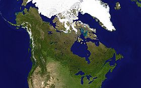
Canadian canoe routes (early)
Encyclopedia
This article covers the water routes used by early explorers of Canada with special emphasis on the fur trade.
s between them. There are no serious barriers to canoe travel east of the Rockies or from the Urals almost to the Pacific. Both expansions were driven and paid for by the fur trade
(mostly beaver in Canada, sable and many others in Siberia). In both countries furs were obtained by the natives and exported by Europeans. In Siberia a band of armed Cossacks would enter a native village and demand yasak
or tribute. In Canada furs were obtained by honest trade. The Russians first entered Siberia with the Conquest of the Khanate of Sibir
in 1582 and reached the Pacific 61 years later at Okhotsk
in 1643. European settlement of Canada began in 1603 and 1608 (Port Royal, Nova Scotia
and Quebec City
). Canadians reached the Arctic in 1789 and the Pacific in 1793 (both by Alexander Mackenzie). For Siberia see Siberian River Routes
.
as far as Albany, but this leads north to the Saint Laurence and westward travel was blocked by the Iroquois
league. The Chesapeake and Delaware Bays lead a short way inland and the other east coast rivers are too short or shallow to be of much use. This leaves the Saint Lawrence River
.
British Era: The second era began when trade reached the pays d'en haut west of Lake Superior. In these cold lands beaver had longer and thicker fur. After the British conquered Canada in 1759 management of the Montreal trade was taken over by English-speakers while the real work continued to be done by French-Canadians. The Montreal-based North West Company
was formed in 1779 largely because distances had become so great as to require a highly-organized transport system (The Athabasca country was 3000 miles from Montreal and a canoe might go 1000 miles in a month). The independent coureur des bois
was replaced by the hired voyageur
. Since the west country was too far for a round trip in one season, each spring, when the ice broke up, boats would set out from Montreal while winterers would start east. They exchanged their goods at Grand Portage on Lake Superior and returned before the rivers froze five months later. To save the cost of hauling food from Montreal Metis
around Winnipeg began the large-scale production of pemmican
. The Hudson Bay trade was diverted southwest to the edge of the prairie where pemmican was picked up to feed the voyageurs on their journey northwest to the Athabasca country. Competition from the Nor'Westers forced the Hudson's Bay Company to build posts in the interior. The two companies competed for a while and, in 1821, merged. Management was taken over by the capital-rich HBC, but trading methods were those of the Montreal-based Nor'Westers. Much trade shifted to York Factory and later some went south to Minnesota
. After 1810 the western posts were linked the British bases on the Oregon coast. By mid-century the HBC ruled an inland empire that stretched from Hudson Bay to the Pacific. The Carlton Trail
became a land route across the prairies. HBC land claims were transferred to Canada by the Rupert's Land Act 1868. From 1874 the North-West Mounted Police began to extend formal government into the area. The fur trade routes grew obsolete from the 1880s with the coming of railways and steamships.

 Seagoing ships can reach Quebec City and smaller ones can reach Montreal. One might think that the route would continue up the Saint Lawrence, but this was not the case. Possible reasons are the Lachine Rapids
and other rapids above Montreal, Niagara Falls
, Iroquois
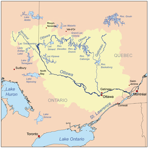
hostility, the poorer quality of southern furs and the lack of large birch trees to make canoes. The route west from Montreal has been called the 'first Trans-Canada Highway'. It ran from near Montreal, up the Ottawa River
, west up the Mattawa River
to Trout Lake
and over the 7-mile La Vase portage at what is now North Bay
on Lake Nipissing
and down the French River
to Georgian Bay
of Lake Huron
. This route was first used by Champlain in 1613 and later. When the Iroquois made the Ottawa dangerous it was possible for small canoes to continue up the Ottawa above the Mattawa and from its sources cross to the Saint-Maurice River
and down to the Saint Lawrence at Trois-Rivières
.
From the French River south to the Jesuit Huron missions at the southern end of Georgian Bay (1626–1640). Or west through the Strait of Mackinac to Lake Michigan
. Or west north of Manitoulin Island
and up the St Marys River
(26 feet difference in elevation) to Lake Superior
. On Lake Superior voyageurs would normally hug the northern shore because of the danger of frequent squalls that could overturn their boats.
The route up the Saint Lawrence to Lake Ontario
, Niagara Falls
, Lake Erie
, Detroit River
, Lake St. Clair, St. Clair River
and lower Lake Huron
developed later (Adrien Jolliet in 1669 was probably the first) and was never the main westward route. North of the Saint Lawrence were many complex lakes and rivers that were sometimes used to go as far as James Bay
.
 Where the US border meets Lake Superior is Grand Portage, Minnesota
. From here to Lake of the Woods the canoe route ran along the current US-Canadian border. Over a 9 miles (14.5 km) portage south of the falls and canyon of the Pigeon River
, west up the 50 miles (80.5 km) long Pigeon River and Arrow River to South Lake, and then across the 400 metres (1,312.3 ft) Height of Land Portage
to North Lake whose waters drain into Hudson Bay. From North Lake down the ? river through a chain of lakes including Gunflint Lake and Basswood Lake to Lac La Croix where the route from Fort William comes in. Down the Loon River to Lake Namakan and north over either of two portages to Rainy Lake
(a depot was established here to shorten the voyage of the Athabasca brigade) and down the Rainy River to Lake of the Woods
210 miles (338 km) west-northwest of Grand Portage. Leaving the US border, northwest down the Winnipeg River
with 26 portages to Lake Winnipeg
, a poor lake for small craft. This area was opened up by La Vérendrye in 1731-1737. Following the current downstream leads to the Nelson River
and Hudson Bay
, which is not very useful. (The Nelson River is difficult and the parallel Hayes River
was preferred. The Hayes route became more important after 1821 when much trade shifted from Montreal to York Factory)
In 1803 it was found that Grand Portage was on the US side of the border and the Lake Superior base was moved 45 miles (72.4 km) northeast to Fort William, Ontario
. For the two routes from Lake Superior see Grand Portage National Monument
and Kaministiquia River
.
A minor route ran Duluth, Minnesota
west and north up the Saint Joseph River
and Embarass River over another Height of Land Portage and north up the Pike River (Minnesota)
and Vermilion River (Minnesota)
to Rainy Lake
on the Grand Portage route. During the negotiations for the Webster-Ashburton Treaty
Britain tried to make this as the Canadian border.
The Saskatchewan River
enters Lake Winnipeg at Grand Rapids, Manitoba
. Around these rapids to Cedar Lake
. [Cedar Lake is one of the chain of lakes that look like a single lake west of Lake Winnipeg. Although it was not much used, a route ran from Cedar Lake south over the 4 miles (6.4 km) Mossy portage to Lake Winnipegosis
and then the mile-and-a-half Meadow Portage to Lake Manitoba
and the at least 5 miles (8 km) of Portage La Prairie to the Assiniboine River
. Another route reached Lake Manitoba from Lake Winnipeg via the Dauphin River
. Up the Saskatchewan, past Cumberland House
and up the North Saskatchewan River
almost to the Rocky Mountains at Fort Edmonton
and Rocky Mountain House, Alberta
. The North Saskatchewan is approximately the southern limit of forested beaver country. There are no portages between Cumberland and Edmonton, but there are sand bars and 125 miles (201.2 km) stretch of strong current east of Prince Albert, Saskatchewan
where canoes were drug upstream on ropes. Above Prince Albert is the La Montée prairie country where voyageurs were fed by buffalo hunters. Both York boats and north canoes were used. Trade was helped by the fact that the Cree Language
was spoken along the whole route. There are, of course, no canoe routes over the Rockies.
The Assiniboine River
which meets the Red River just south of Lake Winnipeg provided another route west. The Red River of the North
, which flows north into the southern tip of Lake Winnipeg gained some importance after 1812 with the establishment of the Red River Colony
and when the Metis
began supplying buffalo Pemmican
to feed the voyageurs
. These are prairie rivers and not good beaver country. Much transport was by horse and Red River cart.
 The axis from Lake Superior to the Mackenzie River runs along the southwest side of the forested beaver country between the prairie to the southwest and the Barren Grounds to the northeast. Here beaver fur is longer and thicker than further southeast. The southern part of the axis was near the source of pemmican
. From the depot at Cumberland House, Saskatchewan
on the lower Saskatchewan River, north up the Sturgeon-Weir River
, across Frog Portage
to the east-flowing Churchill River
which is mostly a chain of lakes, west up the Churchill past the depot on Lac Île-à-la-Crosse, through Peter Pond Lake
to Lac La Loche
and over the 12-mile Methye Portage
to the Clearwater River
whose waters reach the Arctic. The Methye Portage, which was first reached by Peter Pond
in 1778 ranks with Grand Portage as the most difficult of the major portages. West down the Clearwater River to the Athabasca River
at Fort McMurray, north down the Athabasca to the Peace-Athabasca Delta
and the depot at Fort Chipewyan, Alberta
, at the west end of Lake Athabasca
. This was about as far as canoes could reach and return in one season and was the gathering place for furs from the rich Athabasca region and further west. One could continue into poorer country north down the Slave River
to the Great Slave Lake
and northwest down the Mackenzie River
to the Arctic Ocean.
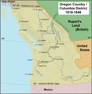
 The inland canoe routes were linked to the British settlements on the Pacific Coast in 1811 when David Thompson
reached the mouth of the Columbia River
. The route was used for messages and light freight but was not practical for heavy freight. Here, horses were used more often than canoes, furs were trapped by non-Indians and the pelts exported by ship. Here they competed, rather successfully, with the American Fur Company
. The Oregon Country
was divided at the 49th parallel in 1846.
The interior of British Columbia was called New Caledonia (Canada)
. Furs were usually taken down the Peace River
and stored at Fort Chipewyan on Lake Athabasca and sent to York Factory the following year. Dogsleds were used.
The far northwest was supplied by an unusual route which was found in 1851 by Robert Campbell (fur trader)
who travelled in the opposite direction from the one described here. From the Mackenzie River delta south up the Peel River
to the depot at Fort McPherson, Northwest Territories
. Then back down the Peel and west up the Rat River (by poling or draging, not paddling) or by a parallel trail and over a half-mile portage to the Little Bell River, then Bell River (Yukon) past a post called Lapierre's House and down the Porcupine River
to Fort Yukon, Alaska
about 300 miles west of Fort McPherson. Then at least 400 miles south-southeast up the Yukon River
and Pelly River
, then the Findlayson and Campbell Rivers and a portage to Frances Lake
, down the Frances River to the Liard River
and east to Fort Simpson on the Mackenzie about 275 miles east of Frances Lake. There was some transport on the Laird, but the Laird river canyon made this difficult.
reached the mouth of the Mississippi from the Great Lakes. From about 1715 the French sought to link the Saint Lawrence and Mississippi basins and bottle up the English on the east coast. From the southeast side of Lake Michigan, east up the St. Joseph River
to near the present site of South Bend, Indiana
and across a short portage to the Kankakee River
, west down to Kankakee, which joins the Des Plaines River
to become the Illinois River
which runs first west and then southwest to the Mississippi. Another route was the Chicago River
and across the Chicago Portage
to the Des Plaines River and south to the Illinois. Alternatively, from the northeast side of Lake Michigan, at the head of Green Bay, up the Fox River
, past serious rapids to Lake Winnebago
, up the Fox and over a short portage
to the Wisconsin River
and southwest to the Mississippi. By the time of the British conquest there were French trading posts from New Orleans up the Mississippi and Illinois Rivers to the Great Lakes.
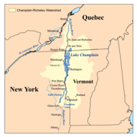
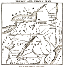 This was the main axis of British-French and British-US military conflict late in the period. From Quebec upriver about a third of the way to Montreal, up the Richelieu River
to Lake Champlain
, portage west parallel to the La Chute River
(230 feet drop in 3½-miles) to Lake George
, overland to the Hudson River
and downstream to New York.
. From Lake Erie, at Fort Presque Isle
(1753), south up an army-built wagon road to Fort Le Boeuf
at the head of the Rivière aux Boeufs (LeBoeuf Creek
), down LeBoeuf Creek to French Creek
to Fort Machault
at its junction with the Allegheny River
and down the Allegany to Fort Duquesne
(1754) at modern-day Pittsburgh. The British response to this move was the beginning of the French and Indian War
.
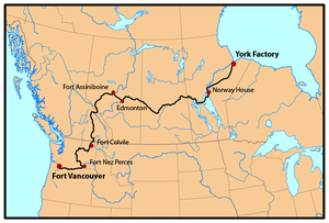
.jpg) The Hudson's Bay Company
The Hudson's Bay Company
began establishing posts on the Bay in 1668. Unlike the French-Canadians, the English were usually content to sit on the coast and let the Indians bring furs to them. 'Asleep by the frozen sea' is how Peter Newman describes it. Movement inland began about 1750 after the French entered the western country and tried to divert the Hudson Bay fur trade to Montreal. The most important route ran from York Factory up the Hayes River
(not the Nelson River) to Norway House at the north end of Lake Winnipeg. Most posts were on the southwest side of the bay. Inland were many complex routes, most being too small for heavy freight canoes.
Main routes from east to west were:
Canada and Siberia
Both Canada and Siberia were explored mainly by river. Both countries have many navigable rivers with short portagePortage
Portage or portaging refers to the practice of carrying watercraft or cargo over land to avoid river obstacles, or between two bodies of water. A place where this carrying occurs is also called a portage; a person doing the carrying is called a porter.The English word portage is derived from the...
s between them. There are no serious barriers to canoe travel east of the Rockies or from the Urals almost to the Pacific. Both expansions were driven and paid for by the fur trade
Fur trade
The fur trade is a worldwide industry dealing in the acquisition and sale of animal fur. Since the establishment of world market for in the early modern period furs of boreal, polar and cold temperate mammalian animals have been the most valued...
(mostly beaver in Canada, sable and many others in Siberia). In both countries furs were obtained by the natives and exported by Europeans. In Siberia a band of armed Cossacks would enter a native village and demand yasak
Yasak
Yasak or yasaq, sometimes iasak, is a Turkic word for "tribute" that was used in Imperial Russia to designate fur tribute exacted from the indigenous peoples of Siberia.- Origin :...
or tribute. In Canada furs were obtained by honest trade. The Russians first entered Siberia with the Conquest of the Khanate of Sibir
Conquest of the Khanate of Sibir
The Khanate of Sibir was a Muslim state located just east of the middle Ural Mountains. Its conquest by Ermak in 1582 was the first event in the Russian conquest of Siberia.-Russia:...
in 1582 and reached the Pacific 61 years later at Okhotsk
Okhotsk
Okhotsk is an urban locality and a seaport at the mouth of the Okhota River on the Sea of Okhotsk, in Okhotsky District, Khabarovsk Krai, Russia. Population: 4,470 ;...
in 1643. European settlement of Canada began in 1603 and 1608 (Port Royal, Nova Scotia
Port Royal, Nova Scotia
Port Royal was the capital of Acadia from 1605 to 1710 and is now a town called Annapolis Royal in the western part of the Canadian province of Nova Scotia. Initially Port Royal was located on the north shore of the Annapolis Basin, Nova Scotia, at the site of the present reconstruction of the...
and Quebec City
Quebec City
Quebec , also Québec, Quebec City or Québec City is the capital of the Canadian province of Quebec and is located within the Capitale-Nationale region. It is the second most populous city in Quebec after Montreal, which is about to the southwest...
). Canadians reached the Arctic in 1789 and the Pacific in 1793 (both by Alexander Mackenzie). For Siberia see Siberian River Routes
Siberian River Routes
Siberian River Routes were the main ways of communication in the Russian Siberia before the 1730s, when roads began to be built. The rivers also were of primary importance in the process of Russian exploration and colonisation of vast Siberian territories...
.
Gateways to the continent
An explorer naturally wishes to travel as far as possible by water. Hudson Bay gets one more than a third of the way across the continent, but it leads to unproductive country and is blocked by ice for most of the year. The Mississippi River is a natural entry point, but it only began to be used in 1718 with the foundation of New Orleans. Early sea ships could follow the Hudson RiverHudson River
The Hudson is a river that flows from north to south through eastern New York. The highest official source is at Lake Tear of the Clouds, on the slopes of Mount Marcy in the Adirondack Mountains. The river itself officially begins in Henderson Lake in Newcomb, New York...
as far as Albany, but this leads north to the Saint Laurence and westward travel was blocked by the Iroquois
Iroquois
The Iroquois , also known as the Haudenosaunee or the "People of the Longhouse", are an association of several tribes of indigenous people of North America...
league. The Chesapeake and Delaware Bays lead a short way inland and the other east coast rivers are too short or shallow to be of much use. This leaves the Saint Lawrence River
Saint Lawrence River
The Saint Lawrence is a large river flowing approximately from southwest to northeast in the middle latitudes of North America, connecting the Great Lakes with the Atlantic Ocean. It is the primary drainage conveyor of the Great Lakes Basin...
.
Two Ages of Trade and Exploration
French Era: In the sixteenth century cod fishermen began trading for furs, especially at Tadoussac on the Saint Lawrence River. With the foundation of Quebec in 1608 Coureurs des bois spread out through the many rivers and lakes to trade with the Indians, while Indians would carry canoe-loads of fur down to Montreal. Nearby tribes became middlemen, drawing furs from further inland. Montreal was the main base where furs were stored before transshipment to Europe. By the end of the period trade and exploration had spread to all the Great Lakes and was extending down the Mississippi. Meanwhile the British maintained posts on Hudson Bay, ignored the interior and waited for Indians to bring furs to them.British Era: The second era began when trade reached the pays d'en haut west of Lake Superior. In these cold lands beaver had longer and thicker fur. After the British conquered Canada in 1759 management of the Montreal trade was taken over by English-speakers while the real work continued to be done by French-Canadians. The Montreal-based North West Company
North West Company
The North West Company was a fur trading business headquartered in Montreal from 1779 to 1821. It competed with increasing success against the Hudson's Bay Company in what was to become Western Canada...
was formed in 1779 largely because distances had become so great as to require a highly-organized transport system (The Athabasca country was 3000 miles from Montreal and a canoe might go 1000 miles in a month). The independent coureur des bois
Coureur des bois
A coureur des bois or coureur de bois was an independent entrepreneurial French-Canadian woodsman who traveled in New France and the interior of North America. They travelled in the woods to trade various things for fur....
was replaced by the hired voyageur
Voyageur
Voyageur is a French word meaning "voyager" or "traveler".Voyageur can refer to:*Voyageurs, persons who transported furs by canoe during the fur trade era....
. Since the west country was too far for a round trip in one season, each spring, when the ice broke up, boats would set out from Montreal while winterers would start east. They exchanged their goods at Grand Portage on Lake Superior and returned before the rivers froze five months later. To save the cost of hauling food from Montreal Metis
Métis people (Canada)
The Métis are one of the Aboriginal peoples in Canada who trace their descent to mixed First Nations parentage. The term was historically a catch-all describing the offspring of any such union, but within generations the culture syncretised into what is today a distinct aboriginal group, with...
around Winnipeg began the large-scale production of pemmican
Pemmican
Pemmican is a concentrated mixture of fat and protein used as a nutritious food. The word comes from the Cree word pimîhkân, which itself is derived from the word pimî, "fat, grease". It was invented by the native peoples of North America...
. The Hudson Bay trade was diverted southwest to the edge of the prairie where pemmican was picked up to feed the voyageurs on their journey northwest to the Athabasca country. Competition from the Nor'Westers forced the Hudson's Bay Company to build posts in the interior. The two companies competed for a while and, in 1821, merged. Management was taken over by the capital-rich HBC, but trading methods were those of the Montreal-based Nor'Westers. Much trade shifted to York Factory and later some went south to Minnesota
Red River Trails
The Red River Trails were a network of ox cart routes connecting the Red River Colony and Fort Garry in British North America with the head of navigation on the Mississippi River in the United States...
. After 1810 the western posts were linked the British bases on the Oregon coast. By mid-century the HBC ruled an inland empire that stretched from Hudson Bay to the Pacific. The Carlton Trail
Carlton Trail
The Carlton Trail was the primary land transportation route connecting the various parts of the Canadian Northwest for most of the 19th Century. It stretched from the Red River Colony up to what is today Fort Qu'Appelle, Saskatchewan via Fort Ellice...
became a land route across the prairies. HBC land claims were transferred to Canada by the Rupert's Land Act 1868. From 1874 the North-West Mounted Police began to extend formal government into the area. The fur trade routes grew obsolete from the 1880s with the coming of railways and steamships.
Saint Lawrence River basin
Lachine Rapids
The Lachine Rapids are a series of rapids on the Saint Lawrence River, between the Island of Montreal and the south shore. They are located near the former city of Lachine....
and other rapids above Montreal, Niagara Falls
Niagara Falls
The Niagara Falls, located on the Niagara River draining Lake Erie into Lake Ontario, is the collective name for the Horseshoe Falls and the adjacent American Falls along with the comparatively small Bridal Veil Falls, which combined form the highest flow rate of any waterfalls in the world and has...
, Iroquois
Iroquois
The Iroquois , also known as the Haudenosaunee or the "People of the Longhouse", are an association of several tribes of indigenous people of North America...
hostility, the poorer quality of southern furs and the lack of large birch trees to make canoes. The route west from Montreal has been called the 'first Trans-Canada Highway'. It ran from near Montreal, up the Ottawa River
Ottawa River
The Ottawa River is a river in the Canadian provinces of Ontario and Quebec. For most of its length, it now defines the border between these two provinces.-Geography:...
, west up the Mattawa River
Mattawa River
The Mattawa River is a river in central Ontario, Canada. It flows east from Trout Lake east of North Bay and enters the Ottawa River at the town of Mattawa. Counting from the head of Trout Lake, it is 76 km in length...
to Trout Lake
Trout Lake (Ontario)
Trout Lake is a lake in municipalities of East Ferris and North Bay, Nipissing District in Northeastern Ontario, Canada, approximately east of the much larger Lake Nipissing. Trout Lake is the source of the Mattawa River and a significant body of water on a well-known historic North American...
and over the 7-mile La Vase portage at what is now North Bay
North Bay, Ontario
North Bay is a city in Northeastern Ontario, Canada. It is the seat of Nipissing District, and takes its name from its position on the shore of Lake Nipissing.-History:...
on Lake Nipissing
Lake Nipissing
Lake Nipissing is a lake in the Canadian province of Ontario. It has a surface area of , a mean elevation of above sea level, and is located between the Ottawa River and Georgian Bay. Excluding the Great Lakes, Lake Nipissing is the fifth-largest lake in Ontario. It is relatively shallow for a...
and down the French River
French River
French River may refer to:*Any river within the country of France -Rivers named "French":*In Canada:**French River, Colchester, Nova Scotia**French River, Pictou, Nova Scotia**French River *In the United States:...
to Georgian Bay
Georgian Bay
Georgian Bay is a large bay of Lake Huron, located entirely within Ontario, Canada...
of Lake Huron
Lake Huron
Lake Huron is one of the five Great Lakes of North America. Hydrologically, it comprises the larger portion of Lake Michigan-Huron. It is bounded on the east by the Canadian province of Ontario and on the west by the state of Michigan in the United States...
. This route was first used by Champlain in 1613 and later. When the Iroquois made the Ottawa dangerous it was possible for small canoes to continue up the Ottawa above the Mattawa and from its sources cross to the Saint-Maurice River
Saint-Maurice River
The Saint-Maurice River is a river in central Quebec which flows south from Gouin Reservoir to empty into the Saint Lawrence River at Trois-Rivières, Quebec. The river is 563 km in length and has a drainage basin of 43,300 km² ....
and down to the Saint Lawrence at Trois-Rivières
Trois-Rivières
Trois-Rivières means three rivers in French and may refer to:in Canada*Trois-Rivières, the largest city in the Mauricie region of Quebec, Canada*Circuit Trois-Rivières, a racetrack in Trois-Rivières, Quebec...
.
From the French River south to the Jesuit Huron missions at the southern end of Georgian Bay (1626–1640). Or west through the Strait of Mackinac to Lake Michigan
Lake Michigan
Lake Michigan is one of the five Great Lakes of North America and the only one located entirely within the United States. It is the second largest of the Great Lakes by volume and the third largest by surface area, after Lake Superior and Lake Huron...
. Or west north of Manitoulin Island
Manitoulin Island
Manitoulin Island is a Canadian island in Lake Huron, in the province of Ontario. It is the largest island in a freshwater lake in the world. In addition to the historic Anishinaabe and European settlement of the island, archeological discoveries at Sheguiandah have demonstrated Paleo-Indian and...
and up the St Marys River
St. Marys River (Michigan-Ontario)
The St. Marys River , sometimes written as the St. Mary's River, drains Lake Superior, starting at the end of Whitefish Bay and flowing 74.5 miles southeast into Lake Huron, with a fall of ....
(26 feet difference in elevation) to Lake Superior
Lake Superior
Lake Superior is the largest of the five traditionally-demarcated Great Lakes of North America. It is bounded to the north by the Canadian province of Ontario and the U.S. state of Minnesota, and to the south by the U.S. states of Wisconsin and Michigan. It is the largest freshwater lake in the...
. On Lake Superior voyageurs would normally hug the northern shore because of the danger of frequent squalls that could overturn their boats.
The route up the Saint Lawrence to Lake Ontario
Lake Ontario
Lake Ontario is one of the five Great Lakes of North America. It is bounded on the north and southwest by the Canadian province of Ontario, and on the south by the American state of New York. Ontario, Canada's most populous province, was named for the lake. In the Wyandot language, ontarío means...
, Niagara Falls
Niagara Falls
The Niagara Falls, located on the Niagara River draining Lake Erie into Lake Ontario, is the collective name for the Horseshoe Falls and the adjacent American Falls along with the comparatively small Bridal Veil Falls, which combined form the highest flow rate of any waterfalls in the world and has...
, Lake Erie
Lake Erie
Lake Erie is the fourth largest lake of the five Great Lakes in North America, and the tenth largest globally. It is the southernmost, shallowest, and smallest by volume of the Great Lakes and therefore also has the shortest average water residence time. It is bounded on the north by the...
, Detroit River
Detroit River
The Detroit River is a strait in the Great Lakes system. The name comes from the French Rivière du Détroit, which translates literally as "River of the Strait". The Detroit River has served an important role in the history of Detroit and is one of the busiest waterways in the world. The river...
, Lake St. Clair, St. Clair River
St. Clair River
The St. Clair River is a river in central North America which drains Lake Huron into Lake St Clair, forming part of the international boundary between the Canadian province of Ontario and the U.S. state of Michigan...
and lower Lake Huron
Lake Huron
Lake Huron is one of the five Great Lakes of North America. Hydrologically, it comprises the larger portion of Lake Michigan-Huron. It is bounded on the east by the Canadian province of Ontario and on the west by the state of Michigan in the United States...
developed later (Adrien Jolliet in 1669 was probably the first) and was never the main westward route. North of the Saint Lawrence were many complex lakes and rivers that were sometimes used to go as far as James Bay
James Bay
James Bay is a large body of water on the southern end of Hudson Bay in Canada. Both bodies of water extend from the Arctic Ocean. James Bay borders the provinces of Quebec and Ontario; islands within the bay are part of Nunavut...
.
Nelson River basin
Grand Portage, Minnesota
Grand Portage is an unorganized territory in Cook County, Minnesota, on Lake Superior, at the northeast corner of the state near the border with northwestern Ontario. The population was 557 at the 2000 census...
. From here to Lake of the Woods the canoe route ran along the current US-Canadian border. Over a 9 miles (14.5 km) portage south of the falls and canyon of the Pigeon River
Pigeon River (Minnesota-Ontario)
The Pigeon River forms part of the US-Canada border between the State of Minnesota and the Province of Ontario west of Lake Superior. In pre-industrial times the river was a waterway of great importance for transportation and trade.-Geography:...
, west up the 50 miles (80.5 km) long Pigeon River and Arrow River to South Lake, and then across the 400 metres (1,312.3 ft) Height of Land Portage
Height of Land Portage
Height of Land Portage is a portage along the historic Boundary Waters route between Canada and the United States. Located at the border of the Canadian province of Ontario and the U.S...
to North Lake whose waters drain into Hudson Bay. From North Lake down the ? river through a chain of lakes including Gunflint Lake and Basswood Lake to Lac La Croix where the route from Fort William comes in. Down the Loon River to Lake Namakan and north over either of two portages to Rainy Lake
Rainy Lake
Rainy Lake is a relatively large freshwater lake that straddles the border between the United States and Canada. The Rainy River issues from the west side of the lake and is harnessed to make hydroelectricity for US and Canadian locations. The U.S...
(a depot was established here to shorten the voyage of the Athabasca brigade) and down the Rainy River to Lake of the Woods
Lake of the Woods
Lake of the Woods is a lake occupying parts of the Canadian provinces of Ontario and Manitoba and the U.S. state of Minnesota. It separates a small land area of Minnesota from the rest of the United States. The Northwest Angle and the town of Angle Township can only be reached from the rest of...
210 miles (338 km) west-northwest of Grand Portage. Leaving the US border, northwest down the Winnipeg River
Winnipeg River
The Winnipeg River is a Canadian river which flows from Lake of the Woods in the province of Ontario to Lake Winnipeg in Manitoba. This river is long from the Norman Dam in Kenora to its mouth at Lake Winnipeg. Its watershed is in area, mainly in Canada. About of this area is in northern...
with 26 portages to Lake Winnipeg
Lake Winnipeg
Lake Winnipeg is a large, lake in central North America, in the province of Manitoba, Canada, with its southern tip about north of the city of Winnipeg...
, a poor lake for small craft. This area was opened up by La Vérendrye in 1731-1737. Following the current downstream leads to the Nelson River
Nelson River
The Nelson River is a river of north-central North America, in the Canadian province of Manitoba. Its full length is , it has mean discharge of , and has a drainage basin of , of which is in the United States...
and Hudson Bay
Hudson Bay
Hudson Bay , sometimes called Hudson's Bay, is a large body of saltwater in northeastern Canada. It drains a very large area, about , that includes parts of Ontario, Quebec, Saskatchewan, Alberta, most of Manitoba, southeastern Nunavut, as well as parts of North Dakota, South Dakota, Minnesota,...
, which is not very useful. (The Nelson River is difficult and the parallel Hayes River
Hayes River
The Hayes River is a river in Northern Region, Manitoba, Canada that flows from Molson Lake to Hudson Bay at York Factory. It was an historically important river in the development of Canada, and is today a Canadian Heritage River and the longest naturally flowing river in Manitoba.-Course:The...
was preferred. The Hayes route became more important after 1821 when much trade shifted from Montreal to York Factory)
In 1803 it was found that Grand Portage was on the US side of the border and the Lake Superior base was moved 45 miles (72.4 km) northeast to Fort William, Ontario
Fort William, Ontario
Fort William was a city in Northern Ontario, located on the Kaministiquia River, at its entrance to Lake Superior. It amalgamated with Port Arthur and the townships of Neebing and McIntyre to form the city of Thunder Bay in January 1970. Ever since then it has been the largest city in Northwestern...
. For the two routes from Lake Superior see Grand Portage National Monument
Grand Portage National Monument
Grand Portage National Monument is a United States National Monument located on the north shore of Lake Superior in northeastern Minnesota that preserves a vital center of fur trade activity and Anishinaabeg Ojibwe heritage....
and Kaministiquia River
Kaministiquia River
The Kaministiquia River is a river which empties into western Lake Superior at the city of Thunder Bay, Ontario. Kaministiquia is an Ojibwe word meaning " with islands" due to two large islands at the mouth of the river...
.
A minor route ran Duluth, Minnesota
Duluth, Minnesota
Duluth is a port city in the U.S. state of Minnesota and is the county seat of Saint Louis County. The fourth largest city in Minnesota, Duluth had a total population of 86,265 in the 2010 census. Duluth is also the second largest city that is located on Lake Superior after Thunder Bay, Ontario,...
west and north up the Saint Joseph River
St. Joseph River (Lake Michigan)
The St. Joseph River is a river, approximately long, in southern Michigan and northern Indiana in the United States. It drains a primarily rural farming area in the watershed of Lake Michigan...
and Embarass River over another Height of Land Portage and north up the Pike River (Minnesota)
Pike River (Minnesota)
-References:***USGS Hydrologic Unit Map - State of Minnesota...
and Vermilion River (Minnesota)
Vermilion River (Minnesota)
The Vermilion River is located in Saint Louis County of northeast Minnesota, between Lake Vermilion Bay and Crane Lake.The Vermilion River's width varies considerably, being the size of a large creek in places and looking like a large lake in another...
to Rainy Lake
Rainy Lake
Rainy Lake is a relatively large freshwater lake that straddles the border between the United States and Canada. The Rainy River issues from the west side of the lake and is harnessed to make hydroelectricity for US and Canadian locations. The U.S...
on the Grand Portage route. During the negotiations for the Webster-Ashburton Treaty
Webster-Ashburton Treaty
The Webster–Ashburton Treaty, signed August 9, 1842, was a treaty resolving several border issues between the United States and the British North American colonies...
Britain tried to make this as the Canadian border.
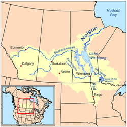
The Saskatchewan River
Saskatchewan River
The Saskatchewan River is a major river in Canada, approximately long, flowing roughly eastward across Saskatchewan and Manitoba to empty into Lake Winnipeg...
enters Lake Winnipeg at Grand Rapids, Manitoba
Grand Rapids, Manitoba
Grand Rapids is a town in Manitoba, Canada located on the northwestern shore of Lake Winnipeg where the Saskatchewan River enters the lake. As the name implies, the river had a significant drop at this point . In modern days, a large hydro electric generating plant has been built...
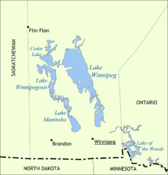
. Around these rapids to Cedar Lake
Cedar Lake
-Cities, towns, townships etc.:*Cedar Lake, Indiana*Cedar Lake Township, Minnesota in Scott County, Minnesota*Cedar Lake, New Jersey*Cedar Lake, Texas*Cedar Lake, Wisconsin, a town in Barron County-Lakes:United States...
. [Cedar Lake is one of the chain of lakes that look like a single lake west of Lake Winnipeg. Although it was not much used, a route ran from Cedar Lake south over the 4 miles (6.4 km) Mossy portage to Lake Winnipegosis
Lake Winnipegosis
Lake Winnipegosis is a large lake in central North America, in Manitoba, Canada, some 300 km northwest of Winnipeg. It is Canada's eleventh-largest lake...
and then the mile-and-a-half Meadow Portage to Lake Manitoba
Lake Manitoba
Lake Manitoba is Canada's thirteenth largest lake and the world's 33rd largest freshwater lake. It is in central North America, in the Canadian province of Manitoba, which is named after the lake...
and the at least 5 miles (8 km) of Portage La Prairie to the Assiniboine River
Assiniboine River
The Assiniboine River is a river that runs through the prairies of Western Canada in Saskatchewan and Manitoba. It is a tributary of the Red River. The Assiniboine is a typical meandering river with a single main channel embanked within a flat, shallow valley in some places and a steep valley in...
. Another route reached Lake Manitoba from Lake Winnipeg via the Dauphin River
Dauphin River
The Dauphin River is a river of Manitoba, Canada. The Dauphin is part of the connection from Lake Manitoba to Lake Winnipeg. The Fairford River flows from Portage Bay in Lake Manitoba through to Lake St. Martin then the Dauphin River continues northeastward from Lake St. Martin into Lake Winnipeg....
. Up the Saskatchewan, past Cumberland House
Cumberland House, Saskatchewan
Cumberland House is a village in Census Division No. 18 in north-eastern Saskatchewan, Canada on the Saskatchewan River. It is the oldest community in Saskatchewan and has a population of about 2000 people...
and up the North Saskatchewan River
North Saskatchewan River
The North Saskatchewan River is a glacier-fed river that flows east from the Canadian Rockies to central Saskatchewan. It is one of two major rivers that join to make up the Saskatchewan River....
almost to the Rocky Mountains at Fort Edmonton
Fort Edmonton
Fort Edmonton was the name of a series of trading posts of the Hudson's Bay Company from 1795 to 1891, all of which were located in central Alberta, Canada...
and Rocky Mountain House, Alberta
Rocky Mountain House, Alberta
Rocky Mountain House is a town in west-central Alberta, Canada, approximately west of the City of Red Deer. It is located at the confluence of the Clearwater and North Saskatchewan Rivers, and at the crossroads of Highway 22 and Highway 11 .- History :The town has a long history dating to the...
. The North Saskatchewan is approximately the southern limit of forested beaver country. There are no portages between Cumberland and Edmonton, but there are sand bars and 125 miles (201.2 km) stretch of strong current east of Prince Albert, Saskatchewan
Prince Albert, Saskatchewan
Prince Albert is the third-largest city in Saskatchewan, Canada. It is situated in the centre of the province on the banks of the North Saskatchewan River. The city is known as the "Gateway to the North" because it is the last major centre along the route to the resources of northern Saskatchewan...
where canoes were drug upstream on ropes. Above Prince Albert is the La Montée prairie country where voyageurs were fed by buffalo hunters. Both York boats and north canoes were used. Trade was helped by the fact that the Cree Language
Cree language
Cree is an Algonquian language spoken by approximately 117,000 people across Canada, from the Northwest Territories and Alberta to Labrador, making it the aboriginal language with the highest number of speakers in Canada. It is also spoken in the U.S. state of Montana...
was spoken along the whole route. There are, of course, no canoe routes over the Rockies.
The Assiniboine River
Assiniboine River
The Assiniboine River is a river that runs through the prairies of Western Canada in Saskatchewan and Manitoba. It is a tributary of the Red River. The Assiniboine is a typical meandering river with a single main channel embanked within a flat, shallow valley in some places and a steep valley in...
which meets the Red River just south of Lake Winnipeg provided another route west. The Red River of the North
Red River of the North
The Red River is a North American river. Originating at the confluence of the Bois de Sioux and Otter Tail rivers in the United States, it flows northward through the Red River Valley and forms the border between the U.S. states of Minnesota and North Dakota before continuing into Manitoba, Canada...
, which flows north into the southern tip of Lake Winnipeg gained some importance after 1812 with the establishment of the Red River Colony
Red River Colony
The Red River Colony was a colonization project set up by Thomas Douglas, 5th Earl of Selkirk in 1811 on of land granted to him by the Hudson's Bay Company under what is referred to as the Selkirk Concession. The colony along the Red River of the North was never very successful...
and when the Metis
Métis people (Canada)
The Métis are one of the Aboriginal peoples in Canada who trace their descent to mixed First Nations parentage. The term was historically a catch-all describing the offspring of any such union, but within generations the culture syncretised into what is today a distinct aboriginal group, with...
began supplying buffalo Pemmican
Pemmican
Pemmican is a concentrated mixture of fat and protein used as a nutritious food. The word comes from the Cree word pimîhkân, which itself is derived from the word pimî, "fat, grease". It was invented by the native peoples of North America...
to feed the voyageurs
Voyageurs
The Voyageurs were the persons who engaged in the transportation of furs by canoe during the fur trade era. Voyageur is a French word which literally translates to "traveler"...
. These are prairie rivers and not good beaver country. Much transport was by horse and Red River cart.
Mackenzie River basin
Pemmican
Pemmican is a concentrated mixture of fat and protein used as a nutritious food. The word comes from the Cree word pimîhkân, which itself is derived from the word pimî, "fat, grease". It was invented by the native peoples of North America...
. From the depot at Cumberland House, Saskatchewan
Cumberland House, Saskatchewan
Cumberland House is a village in Census Division No. 18 in north-eastern Saskatchewan, Canada on the Saskatchewan River. It is the oldest community in Saskatchewan and has a population of about 2000 people...
on the lower Saskatchewan River, north up the Sturgeon-Weir River
Sturgeon-Weir River
The Sturgeon-Weir River is a river in east-central Saskatchewan, Canada. It flows about 110 miles south-southeast to join the Saskatchewan River at Cumberland House, Saskatchewan. It was on the main voyageur route from eastern Canada northeast to the Mackenzie River basin. Its steep gradient led...
, across Frog Portage
Frog Portage
Frog Portage or Portage du Traite was one of the most important portages on the voyageur route from eastern Canada to the Mackenzie River basin. It connects the Saskatchewan River and Churchill River basins...
to the east-flowing Churchill River
Churchill River (Hudson Bay)
The Churchill River is a major river in Alberta, Saskatchewan and Manitoba, Canada. From the head of the Churchill Lake it is 1,609 km long. It was named after John Churchill, 1st Duke of Marlborough and governor of the Hudson's Bay Company from 1685 to 1691...
which is mostly a chain of lakes, west up the Churchill past the depot on Lac Île-à-la-Crosse, through Peter Pond Lake
Peter Pond Lake
Peter Pond Lake is a glacial lake in Saskatchewan, Canada. It is located in northwestern Saskatchewan in the Boreal Forest and Canadian Shield within the Churchill River drainage basin. It was on the fur trade route to the Methye Portage which connected eastern Canada to the MacKenzie River area....
to Lac La Loche
La Loche
La Loche is a northern village located in northwestern Saskatchewan. The second largest community in northern Saskatchewan, it is located on Highway 155 on the eastern shore of Lac La Loche in Canada's boreal forest....
and over the 12-mile Methye Portage
Methye Portage
The Methye Portage or Portage La Loche in northwestern Saskatchewan was one of the most important portages in the old fur-trade route across Canada. It connected the Mackenzie River basin to rivers that ran east to the Atlantic. It was reached by Peter Pond in 1778 and abandoned in 1883 when...
to the Clearwater River
Clearwater River (Saskatchewan)
Clearwater River is the name of a river in the Canadian provinces of Saskatchewan and Alberta.-Course:The Clearwater River totals 295 kilometres in length and rises in northwestern Saskatchewan in the northern forest region of the Precambrian Shield. From its headwaters at Broach Lake it flows...
whose waters reach the Arctic. The Methye Portage, which was first reached by Peter Pond
Peter Pond
Peter Pond was born in Milford, Connecticut. He was a soldier with a Connecticut regiment, a fur trader, a founding member of the North West Company, an explorer and a cartographer.-Biography:...
in 1778 ranks with Grand Portage as the most difficult of the major portages. West down the Clearwater River to the Athabasca River
Athabasca River
The Athabasca River originates from the Columbia Glacier of the Columbia Icefield in Jasper National Park in Alberta, Canada...
at Fort McMurray, north down the Athabasca to the Peace-Athabasca Delta
Peace-Athabasca Delta
The Peace–Athabasca Delta is a large freshwater, inland delta in northeastern Alberta located where the Peace and Athabasca Rivers join the Slave River at the western end of Lake Athabasca.-Conservation :...
and the depot at Fort Chipewyan, Alberta
Fort Chipewyan, Alberta
Fort Chipewyan, commonly referred to as Fort Chip, is a hamlet in northern Alberta, Canada within the Regional Municipality of Wood Buffalo. It is located on the western tip of Lake Athabasca, adjacent to Wood Buffalo National Park, approximately north of Fort McMurray.Fort Chipewyan is one of...
, at the west end of Lake Athabasca
Lake Athabasca
Lake Athabasca is located in the northwest corner of Saskatchewan and the northeast corner of Alberta between 58° and 60° N.-History:The name in the Dene language originally referred only to the large delta formed by the confluence the Athabasca River at the southwest corner of the lake...
. This was about as far as canoes could reach and return in one season and was the gathering place for furs from the rich Athabasca region and further west. One could continue into poorer country north down the Slave River
Slave River
The Slave River is a Canadian river that flows from Lake Athabasca in northeastern Alberta and empties into Great Slave Lake in the Northwest Territories....
to the Great Slave Lake
Great Slave Lake
Great Slave Lake is the second-largest lake in the Northwest Territories of Canada , the deepest lake in North America at , and the ninth-largest lake in the world. It is long and wide. It covers an area of in the southern part of the territory. Its given volume ranges from to and up to ...
and northwest down the Mackenzie River
Mackenzie River
The Mackenzie River is the largest river system in Canada. It flows through a vast, isolated region of forest and tundra entirely within the country's Northwest Territories, although its many tributaries reach into four other Canadian provinces and territories...
to the Arctic Ocean.
Pacific Coast
David Thompson (explorer)
David Thompson was an English-Canadian fur trader, surveyor, and map-maker, known to some native peoples as "Koo-Koo-Sint" or "the Stargazer"...
reached the mouth of the Columbia River
Columbia River
The Columbia River is the largest river in the Pacific Northwest region of North America. The river rises in the Rocky Mountains of British Columbia, Canada, flows northwest and then south into the U.S. state of Washington, then turns west to form most of the border between Washington and the state...
. The route was used for messages and light freight but was not practical for heavy freight. Here, horses were used more often than canoes, furs were trapped by non-Indians and the pelts exported by ship. Here they competed, rather successfully, with the American Fur Company
American Fur Company
The American Fur Company was founded by John Jacob Astor in 1808. The company grew to monopolize the fur trade in the United States by 1830, and became one of the largest businesses in the country. The company was one the first great trusts in American business...
. The Oregon Country
Oregon Country
The Oregon Country was a predominantly American term referring to a disputed ownership region of the Pacific Northwest of North America. The region was occupied by British and French Canadian fur traders from before 1810, and American settlers from the mid-1830s, with its coastal areas north from...
was divided at the 49th parallel in 1846.
The interior of British Columbia was called New Caledonia (Canada)
New Caledonia (Canada)
New Caledonia was the name given to a district of the Hudson's Bay Company that comprised the territory largely coterminous with the present-day province of British Columbia, Canada. Though not a British colony, New Caledonia was part of the British claim to North America. Its administrative...
. Furs were usually taken down the Peace River
Peace River (Canada)
The Peace River is a river in Canada that originates in the Rocky Mountains of northern British Columbia and flows to the northeast through northern Alberta. The Peace River flows into the Slave River, a tributary of the Mackenzie River. The Mackenzie is the 12th longest river in the world,...
and stored at Fort Chipewyan on Lake Athabasca and sent to York Factory the following year. Dogsleds were used.
The far northwest was supplied by an unusual route which was found in 1851 by Robert Campbell (fur trader)
Robert Campbell (fur trader)
Robert Campbell was a Hudson's Bay Company fur trader and explorer. He explored a large part of the southern Yukon and established Fort Frances, Yukon on Frances Lake in the Liard River basin and Fort Selkirk, Yukon at the juncture of the Yukon River and the Pelly River. He was for a time in...
who travelled in the opposite direction from the one described here. From the Mackenzie River delta south up the Peel River
Peel River
The Peel River may refer to:*Peel River in Australia*Peel River in the Yukon and Northwest Territories, Canada...
to the depot at Fort McPherson, Northwest Territories
Fort McPherson, Northwest Territories
Fort McPherson is a hamlet located in the Inuvik Region of the Northwest Territories, Canada. It is located on the east bank of the Peel River and is south of Inuvik on the Dempster Highway....
. Then back down the Peel and west up the Rat River (by poling or draging, not paddling) or by a parallel trail and over a half-mile portage to the Little Bell River, then Bell River (Yukon) past a post called Lapierre's House and down the Porcupine River
Porcupine River
The Porcupine River is a river that runs through Alaska and the Yukon. Having its source in the Ogilvie Mountains north of Dawson City, Yukon, it flows north, veers to the southwest, goes through the community of Old Crow, Yukon, flowing into the Yukon River at Fort Yukon, Alaska...
to Fort Yukon, Alaska
Fort Yukon, Alaska
As of the census of 2000, there were 595 people, 225 households, and 137 families residing in the city. The population density was 85.0 people per square mile . There were 317 housing units at an average density of 45.3 per square mile...
about 300 miles west of Fort McPherson. Then at least 400 miles south-southeast up the Yukon River
Yukon River
The Yukon River is a major watercourse of northwestern North America. The source of the river is located in British Columbia, Canada. The next portion lies in, and gives its name to Yukon Territory. The lower half of the river lies in the U.S. state of Alaska. The river is long and empties into...
and Pelly River
Pelly River
The Pelly River is a river in Canada, and is a headstream of the Yukon River. The river originates west of the Mackenzie Mountains and flows 530 km long through the south central Yukon. The Pelly has two main tributaries, the Ross and Macmillan rivers.The river was named by Robert Campbell in...
, then the Findlayson and Campbell Rivers and a portage to Frances Lake
Frances Lake
-References:*...
, down the Frances River to the Liard River
Liard River
The Liard River flows through Yukon, British Columbia and the Northwest Territories, Canada. Rising in the Saint Cyr Range of the Pelly Mountains in southeastern Yukon, it flows southeast through British Columbia, marking the northern end of the Rocky Mountains and then curving northeast back...
and east to Fort Simpson on the Mackenzie about 275 miles east of Frances Lake. There was some transport on the Laird, but the Laird river canyon made this difficult.
Mississippi basin
In 1682 La SalleRené-Robert Cavelier, Sieur de La Salle
René-Robert Cavelier, Sieur de La Salle, or Robert de LaSalle was a French explorer. He explored the Great Lakes region of the United States and Canada, the Mississippi River, and the Gulf of Mexico...
reached the mouth of the Mississippi from the Great Lakes. From about 1715 the French sought to link the Saint Lawrence and Mississippi basins and bottle up the English on the east coast. From the southeast side of Lake Michigan, east up the St. Joseph River
St. Joseph River (Michigan)
St. Joseph River may refer to the following streams in the U.S. state of Michigan:* St. Joseph River , rises in Hillsdale County and flows primarily to the west into Lake Michigan...
to near the present site of South Bend, Indiana
South Bend, Indiana
The city of South Bend is the county seat of St. Joseph County, Indiana, United States, on the St. Joseph River near its southernmost bend, from which it derives its name. As of the 2010 Census, the city had a total of 101,168 residents; its Metropolitan Statistical Area had a population of 316,663...
and across a short portage to the Kankakee River
Kankakee River
The Kankakee River is a tributary of the Illinois River, approximately long, in northwestern Indiana and northeastern Illinois in the United States. At one time the river drained one of the largest wetlands in North America and furnished a significant portage between the Great Lakes and the...
, west down to Kankakee, which joins the Des Plaines River
Des Plaines River
The Des Plaines River is a river that flows southward for through southern Wisconsin and northern Illinois in the U.S. Midwest, eventually meeting the Kankakee River west of Channahon to form the Illinois River, a tributary of the Mississippi River....
to become the Illinois River
Illinois River
The Illinois River is a principal tributary of the Mississippi River, approximately long, in the State of Illinois. The river drains a large section of central Illinois, with a drainage basin of . This river was important among Native Americans and early French traders as the principal water route...
which runs first west and then southwest to the Mississippi. Another route was the Chicago River
Chicago River
The Chicago River is a system of rivers and canals with a combined length of that runs through the city of the same name, including its center . Though not especially long, the river is notable for being the reason why Chicago became an important location, as the link between the Great Lakes and...
and across the Chicago Portage
Chicago Portage
The Chicago Portage connects the watersheds and the navigable waterways of the Mississippi River and the Great Lakes. It crosses the continental divide that separates the Great Lakes and Gulf of St. Lawrence watersheds from the Gulf of Mexico watershed.Near Chicago, the St...
to the Des Plaines River and south to the Illinois. Alternatively, from the northeast side of Lake Michigan, at the head of Green Bay, up the Fox River
Fox River (Wisconsin)
The Fox River is a river in eastern and central Wisconsin in the United States. Along the banks is a chain of cities, including Oshkosh, Neenah, Menasha, Appleton, Little Chute, Kimberly, Combined Locks, and Kaukauna. Except for Oshkosh, these cities refer to themselves as the Fox Cities...
, past serious rapids to Lake Winnebago
Lake Winnebago
Lake Winnebago is a freshwater lake in eastern Wisconsin, United States. It is the largest lake entirely within the state.-Statistics:...
, up the Fox and over a short portage
Fox-Wisconsin Waterway
The Fox–Wisconsin Waterway is a waterway formed by the Fox and Wisconsin Rivers. First used by European settlers in 1673 during the expedition of Marquette & Joliet, it was one of the principal routes used by travelers between the Great Lakes and the Mississippi River until the completion of the...
to the Wisconsin River
Wisconsin River
-External links:* * * , Wisconsin Historical Society* * * *...
and southwest to the Mississippi. By the time of the British conquest there were French trading posts from New Orleans up the Mississippi and Illinois Rivers to the Great Lakes.
Lake-Champlain-Hudson River
Richelieu River
The Richelieu River is a river in Quebec, Canada. It flows from the north end of Lake Champlain about north, ending at the confluence with the St. Lawrence River at Sorel-Tracy, Quebec downstream and northeast of Montreal...
to Lake Champlain
Lake Champlain
Lake Champlain is a natural, freshwater lake in North America, located mainly within the borders of the United States but partially situated across the Canada—United States border in the Canadian province of Quebec.The New York portion of the Champlain Valley includes the eastern portions of...
, portage west parallel to the La Chute River
La Chute River
The La Chute River is a short, fast-moving river, near the Vermont-New York State border, now almost wholly contained within the municipality of Ticonderoga, New York, connecting the northern end and outlet of the long Lake George and the southern end of Lake Champlain through many falls and...
(230 feet drop in 3½-miles) to Lake George
Lake George (New York)
Lake George, nicknamed the Queen of American Lakes, is a long, narrow oligotrophic lake draining northwards into Lake Champlain and the St. Lawrence River Drainage basin located at the southeast base of the Adirondack Mountains in northern New York, U.S.A.. It lies within the upper region of the...
, overland to the Hudson River
Hudson River
The Hudson is a river that flows from north to south through eastern New York. The highest official source is at Lake Tear of the Clouds, on the slopes of Mount Marcy in the Adirondack Mountains. The river itself officially begins in Henderson Lake in Newcomb, New York...
and downstream to New York.
Upper Ohio River basin
Although the French had long been in the Ohio country (La Salle in 1669, Fort des Miamis from 1715), this area only became important after about 1743 when the French tried to block Anglo-American expansion into the Ohio countryOhio Country
The Ohio Country was the name used in the 18th century for the regions of North America west of the Appalachian Mountains and in the region of the upper Ohio River south of Lake Erie...
. From Lake Erie, at Fort Presque Isle
Fort Presque Isle
Fort Presque Isle was a fort built by French soldiers in 1753 along Presque Isle Bay at present-day Erie, Pennsylvania...
(1753), south up an army-built wagon road to Fort Le Boeuf
Fort Le Boeuf
Fort Le Boeuf, , was a fort established by the French in 1753 on a fork of French Creek, in present-day Waterford, in northwest Pennsylvania...
at the head of the Rivière aux Boeufs (LeBoeuf Creek
LeBoeuf Creek
LeBoeuf Creek is an long tributary of French Creek in Erie County, Pennsylvania in the United States. It has a drainage basin of .- Course :...
), down LeBoeuf Creek to French Creek
French Creek (Allegheny River)
French Creek is a tributary of the Allegheny River in northwestern Pennsylvania and western New York in the United States.- Etymology :...
to Fort Machault
Fort Machault
Fort Machault was a fort built by the French in 1754 near the confluence of French Creek with the Allegheny River, at present-day Franklin, in northwest Pennsylvania. The fort was part of a line that included Fort Presque Isle, Fort Le Boeuf, and Fort Duquesne.- Description:The fort was built on a...
at its junction with the Allegheny River
Allegheny River
The Allegheny River is a principal tributary of the Ohio River; it is located in the Eastern United States. The Allegheny River joins with the Monongahela River to form the Ohio River at the "Point" of Point State Park in Downtown Pittsburgh, Pennsylvania...
and down the Allegany to Fort Duquesne
Fort Duquesne
Fort Duquesne was a fort established by the French in 1754, at the junction of the Allegheny and Monongahela rivers in what is now downtown Pittsburgh in the state of Pennsylvania....
(1754) at modern-day Pittsburgh. The British response to this move was the beginning of the French and Indian War
French and Indian War
The French and Indian War is the common American name for the war between Great Britain and France in North America from 1754 to 1763. In 1756, the war erupted into the world-wide conflict known as the Seven Years' War and thus came to be regarded as the North American theater of that war...
.
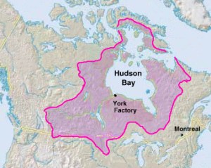
Hudson Bay
Hudson's Bay Company
The Hudson's Bay Company , abbreviated HBC, or "The Bay" is the oldest commercial corporation in North America and one of the oldest in the world. A fur trading business for much of its existence, today Hudson's Bay Company owns and operates retail stores throughout Canada...
began establishing posts on the Bay in 1668. Unlike the French-Canadians, the English were usually content to sit on the coast and let the Indians bring furs to them. 'Asleep by the frozen sea' is how Peter Newman describes it. Movement inland began about 1750 after the French entered the western country and tried to divert the Hudson Bay fur trade to Montreal. The most important route ran from York Factory up the Hayes River
Hayes River
The Hayes River is a river in Northern Region, Manitoba, Canada that flows from Molson Lake to Hudson Bay at York Factory. It was an historically important river in the development of Canada, and is today a Canadian Heritage River and the longest naturally flowing river in Manitoba.-Course:The...
(not the Nelson River) to Norway House at the north end of Lake Winnipeg. Most posts were on the southwest side of the bay. Inland were many complex routes, most being too small for heavy freight canoes.
Main routes from east to west were:
- On James BayJames BayJames Bay is a large body of water on the southern end of Hudson Bay in Canada. Both bodies of water extend from the Arctic Ocean. James Bay borders the provinces of Quebec and Ontario; islands within the bay are part of Nunavut...
- North of the Eastmain were Barren Grounds with few beaver.
- Eastmain RiverEastmain RiverThe Eastmain River is a river in northwestern Quebec which rises in north central Quebec and flows 800 km west to drain into James Bay. 'East Main' is an old name for the east side of James Bay. This river drains an area of 46,400 km²...
from James Bay east. - Rupert RiverRupert RiverThe Rupert River is one of the largest rivers in Quebec, Canada. From its headwaters in Lake Mistassini, the largest natural lake in Québec, it flows west into Rupert Bay on James Bay. The Rupert drains an area of . There is some extremely large whitewater on the river, but paddlers can avoid...
with Rupert House: Rupert Bay at the southeast corner of James Bay, east up the Rupert to Lake MistassiniLake MistassiniLake Mistassini is the largest natural lake by surface area in the province of Quebec, Canada, with a total surface area of approximately 2,335 km² and a net area of 2,164 km². It is located in the Jamésie region of the province, approximately east of James Bay...
, over to Lake Saint-Jean and down the Saguenay RiverSaguenay RiverThe Saguenay River is a major river of Quebec, Canada.It drains Lac Saint-Jean in the Laurentian Highlands, leaving at Alma and running east, and passes the city of Saguenay. It drains into the Saint Lawrence River at Tadoussac....
to the Saint Lawrence at Tadoussac. - Nottaway RiverNottaway RiverThe Nottaway River is a river in Quebec, Canada. The river drains Lake Matagami and travels north-west before emptying into Rupert Bay at the south end of James Bay. Its drainage basin is and has a mean discharge of 1190 m³/s...
: Rupert Bay southeast to Lake MatagamiLake MatagamiLake Matagami is a lake in south-western Quebec, Canada. It is located just north-northeast of the town of Matagami....
. - Moose RiverMoose RiverMoose River may refer to:Rivers:*Moose River *Moose River *Moose River *Moose River *Moose River *Moose River *Moose River Places:*Moose River, Maine...
with Moose Factory on the south end of James Bay: 1) south:Moose River, Abitibi RiverAbitibi RiverThe Abitibi River is a river in northeastern Ontario, Canada, which flows northwest from Lake Abitibi to join the Moose River which empties into James Bay. This river is long.The river was an important fur trading route for the Hudson's Bay Company...
, Lake AbitibiLake AbitibiLake Abitibi is a lake in northeastern Ontario and western Quebec, Canada. The lake is separated in two distinct portions by a short narrows, making it actually 2 lakes. Its total area is 931 km², and net area 903 km². The lake is shallow and studded with islands...
, portage to the upper Ottawa River near Lake TimiskamingLake TimiskamingLake Timiskaming is a large freshwater lake on the provincial border between Ontario and Quebec, Canada. The lake, which forms part of the Ottawa River, is in length and covers an area of almost . Its water level ranges between and above sea-level, with a mean annual average of . The lake is...
. This was the best route from James Bay to the Ottawa and was used by the Hudson Bay expedition (1686)Hudson Bay expedition (1686)The Hudson Bay expedition of 1686 was one of the Anglo-French conflicts on Hudson Bay. It was the first several expeditions sent from New France against the trading outposts of the Hudson's Bay Company in the southern reaches of Hudson Bay...
; 2) southwest: Moose River, Missinaibi RiverMissinaibi RiverThe Missinaibi River is a river in northern Ontario, Canada, which flows northeast from Missinaibi Lake, north of Chapleau, and empties into the Moose River, which drains into James Bay. This river is in length...
, portage to the Michipicoten RiverMichipicoten RiverThe Michipicoten River is a river in the Algoma District of northern Ontario, Canada, which flows from Dog Lake and joins with the Magpie River to empty into Michipicoten Bay on Lake Superior near the town of Wawa...
to Lake Superior at Wawa, OntarioWawa, OntarioWawa is a township in the Canadian province of Ontario, located within the Algoma District. Formerly known as the township of Michipicoten, the township was officially renamed for its largest and best-known community in 2009....
. This route was used to supply Lake Superior from Hudson Bay. - Albany RiverAlbany RiverThe Albany River is a river in Northern Ontario, Canada, which flows northeast from Lake St. Joseph in Northwestern Ontario and empties into James Bay. It is long to the head of the Cat River, tying it with the Severn River for the title of longest river in Ontario...
with Fort Albany, OntarioFort Albany, OntarioFort Albany First Nation is a community in within the Cochrane District of Northern Ontario, Canada. Situated on the southern shore of the Albany River, Fort Albany First Nation is only accessible by air or by winter road....
on the west side of James Bay with Henley House (1743) 120 miles upstream: 1) southwest: up the Albany, up the Ogoki RiverOgoki RiverThe Ogoki River is a river in the Thunder Bay and Cochrane Districts of Ontario.The river flows northeast from lakes west of Lake Nipigon to Ogoki, where it joins the Albany River which empties into James Bay. The river is 480 km in length...
, cross to Lake NipigonLake NipigonLake Nipigon is the largest lake entirely within the boundaries of the Canadian province of Ontario . It is sometimes described as the sixth Great Lake. Lying 260 metres above sea level, the lake drains into the Nipigon River and thence into Nipigon Bay of Lake Superior...
and south to Lake Superior; 2) West: Albany River, Ogoki River, west up the St Joseph (?) River to Lake St. JosephLake St. JosephLake St. Joseph is a large body of water located in Northwestern Ontario. It is accessed by Highway 599 from the town of Ignace. The closest town is Pickle Lake. This lake is a large freshwater fishery with a wilderness designation. Persons wishing to fish this lake must receive a special...
, portage to a river going south to Lac SeulLac SeulLac Seul is a large, crescent shaped lake in northwestern Ontario, Canada. It is approximately long. It has a maximum depth of 47.2 m, with a surface elevation of 357 m above sea level. It is the second largest body of water entirely within the province of Ontario. The lake consists of open...
and down the English River (Ontario)English River (Ontario)The English River flows through Lac Seul to join the Winnipeg River. The river is 615 km in length. There are several hydroelectric plants on this river.Tributaries of this river include the Vermilion River and the Wabigoon River...
to the Winnipeg River.
- Severn River (northern Ontario)Severn River (northern Ontario)The Severn River is a river in northern Ontario. The northern Ontario river has its headwaters near the western border of the province. From the head of the Black Birch River, the Severn River is long and its drainage basin is 102,800 km² , a small portion of which is in Manitoba...
with Fort Severn on the 'shoulder' west of James Bay. The Severn flows northeast from the general area of Lake St. JosephLake St. JosephLake St. Joseph is a large body of water located in Northwestern Ontario. It is accessed by Highway 599 from the town of Ignace. The closest town is Pickle Lake. This lake is a large freshwater fishery with a wilderness designation. Persons wishing to fish this lake must receive a special... - Hayes RiverHayes RiverThe Hayes River is a river in Northern Region, Manitoba, Canada that flows from Molson Lake to Hudson Bay at York Factory. It was an historically important river in the development of Canada, and is today a Canadian Heritage River and the longest naturally flowing river in Manitoba.-Course:The...
with York Factory, ManitobaYork Factory, ManitobaYork Factory was a settlement and factory located on the southwestern shore of Hudson Bay in northeastern Manitoba, Canada, at the mouth of the Hayes River, approximately south-southeast of Churchill. The settlement was headquarters of the Hudson's Bay Company's Northern Department, from 1821 to...
: York Factory was the Hudson's Bay Company base of operations. Up most of the Hayes, across the Echimamish RiverEchimamish RiverThe Echimamish River is a river bifurcation in Manitoba. Like the better-known Casiquiare canal it has the curious property of flowing between two river systems, in this case, the Hayes River and the Nelson River. Located 50 or so miles northeast to the northern tip of Lake Winnipeg, it is about 40...
to the upper Nelson RiverNelson RiverThe Nelson River is a river of north-central North America, in the Canadian province of Manitoba. Its full length is , it has mean discharge of , and has a drainage basin of , of which is in the United States...
and upstream to Norway House, ManitobaNorway House, Manitoba- Treaty and York Boat Days :Held annually each summer, the York Boat events serve as the main attraction.-External links:* * * *...
at the north end of Lake Winnipeg. - Nelson RiverNelson RiverThe Nelson River is a river of north-central North America, in the Canadian province of Manitoba. Its full length is , it has mean discharge of , and has a drainage basin of , of which is in the United States...
with Port NelsonPort NelsonPort Nelson may refer to:* Port Nelson, Manitoba* Port Nelson, Newfoundland and Labrador* Port Nelson, Australia* Port Nelson, New Zealand...
just north of the mouth of the Hayes. Although the Nelson drains Lake Winnipeg, this route was avoided in preference to the Hayes. - Churchill River (Hudson Bay)Churchill River (Hudson Bay)The Churchill River is a major river in Alberta, Saskatchewan and Manitoba, Canada. From the head of the Churchill Lake it is 1,609 km long. It was named after John Churchill, 1st Duke of Marlborough and governor of the Hudson's Bay Company from 1685 to 1691...
with Fort ChurchillFort ChurchillFort Churchill may refer to:* Fort Churchill , Manitoba* Prince of Wales Fort, Manitoba, also known as Fort Churchill* Fort Churchill, located in Fort Churchill State Historic Park, Nevada...
: This route was used mainly by Chipewyans to bring furs down from the rich Athabasca country. The route ran from the east end of Lake AthabascaLake AthabascaLake Athabasca is located in the northwest corner of Saskatchewan and the northeast corner of Alberta between 58° and 60° N.-History:The name in the Dene language originally referred only to the large delta formed by the confluence the Athabasca River at the southwest corner of the lake...
up the Fond du Lac River (Saskatchewan) to Wollaston LakeWollaston LakeWollaston Lake is located in northeastern Saskatchewan, Canada. With a surface area of 2286 km² , it is the largest lake in the world that drains naturally in two directions...
and south through Reindeer LakeReindeer LakeReindeer Lake is a lake in Western Canada located on the border between northeastern Saskatchewan and northwestern Manitoba, with the majority in Saskatchewan. The name of the lake appears to be a translation of the Algonquian name...
to the Churchill. This route was used by George SimpsonGeorge Simpson (administrator)Sir George Simpson was a Scots-Quebecer and employee of the Hudson's Bay Company . His title was Governor-in-Chief of Rupert's Land and administrator over the Northwest Territories and Columbia Department in British North America from 1821 to 1860.-Early years:George Simpson was born in Dingwall,...
in 1824 but was rarely used by Europeans because the large lakes retain their ice long into the season.
- Inland between the Churchill and Hayes Rivers: Smaller indian canoes used the Upper and Middle Tracts between the Hayes and Nelson. These routes grew obsolete after 1774 when Cumberland House, SaskatchewanCumberland House, SaskatchewanCumberland House is a village in Census Division No. 18 in north-eastern Saskatchewan, Canada on the Saskatchewan River. It is the oldest community in Saskatchewan and has a population of about 2000 people...
was founded, which allowed transport by heavy freight canoes and York boatYork boatThe York boat was an inland boat used by the Hudson's Bay Company to carry furs and trade goods along inland waterways in Rupert's Land and the Columbia District. It was named after York Factory, the headquarters of the HBC, and modeled after Orkney Islands fishing boats...
s.- Middle Tract: One branch left the Hayes about 100 miles from the Bay and went up the Fox River (Manitoba)Fox River (Manitoba)The Fox River is a river in northern Manitoba, Canada. It flows east-northeast parallel to and between the Nelson River to the north and the Hayes River to the south. It joins the Hayes about 75 miles southeast of its mouth on Hudson Bay. Seventy five or so miles above its juncture with the Hayes...
and Bigstone River to Utik (Deer) Lake and somehow over to Cross Lake, ManitobaCross Lake, ManitobaCross Lake is the name of two closely related, adjoining but independent communities in the Canadian Province of Manitoba. One of the Cross Lakes is the Cross Lake Indian Reserve where the main urban area is called Cross Lake...
on the Nelson. The other left the Hayes at Oxford LakeOxford LakeOxford Lake is a lake on the Hayes River in Manitoba, Canada. It is vaguely man-shaped, with a 'head' on the east, a 'neck', a northwest-southeast shoulder line and a 'torso' that tapers to a point in the west. The head is about 7 by 5 miles, the neck one mile across and the shoulder line 11...
and went up the Carrot River and crossed to Walker Lake which connects to Cross Lake about 50 miles west of Oxford Lake. From the west end of Cross Lake, up the Minago River and over a low divide to Moose Lake and along the Summerberry River to the Saskatchewan River. - Upper Tract: began on the Nelson River at Split Lake, ManitobaSplit Lake, ManitobaSplit Lake is a community in Manitoba on the north shore of Split Lake on Nelson River about 150 miles west southwest of the river's mouth at Hudson Bay....
, somehow avoiding about 150 difficult miles of the lower Nelson, and went about 200 miles west-southwest up the Grass River, over the Cranberry Portage to the Goose River and down the Goose and Sturgeon-Weir RiverSturgeon-Weir RiverThe Sturgeon-Weir River is a river in east-central Saskatchewan, Canada. It flows about 110 miles south-southeast to join the Saskatchewan River at Cumberland House, Saskatchewan. It was on the main voyageur route from eastern Canada northeast to the Mackenzie River basin. Its steep gradient led...
to Cumberland LakeCumberland LakeCumberland Lake is a glacial lake of Saskatchewan, Canada.It is located in the Cumberland Delta in East-Central Saskatchewan about 60 km from the Manitoba border. Cumberland House and Cumberland House Provincial Historic Park are located on the south shore and is accessed by Highway 123. The...
on the Saskatchewan River about 50 miles west of the start of the Middle Tract. - Another route connected the Nelson and Churchill. It ran from Split Lake west up the Burntwood RiverBurntwood RiverThe Burntwood River is a river in northeast Manitoba, Canada between the Churchill River and the Nelson River. Outsiders may know it as the river that passes through Thompson, Manitoba. It is over 200 miles long and flows mostly east to join the Nelson River at Split Lake, Manitoba. Near its...
and a portage via the Kississing RiverKississing LakeKississing Lake is a lake in western Manitoba, Canada approximately 30 kilometres northeast of Flin Flon. The Kississing River drains it northeast into Flatrock Lake on the Churchill River. The 1,705 yard Kississing Portage connected the Churchill with the Burntwood River....
to the Churchill and up to Frog PortageFrog PortageFrog Portage or Portage du Traite was one of the most important portages on the voyageur route from eastern Canada to the Mackenzie River basin. It connects the Saskatchewan River and Churchill River basins...
.
- Middle Tract: One branch left the Hayes about 100 miles from the Bay and went up the Fox River (Manitoba)
- north of the Churchill is Barren Grounds