
Winnipeg River
Encyclopedia
Canada
Canada is a North American country consisting of ten provinces and three territories. Located in the northern part of the continent, it extends from the Atlantic Ocean in the east to the Pacific Ocean in the west, and northward into the Arctic Ocean...
river
River
A river is a natural watercourse, usually freshwater, flowing towards an ocean, a lake, a sea, or another river. In a few cases, a river simply flows into the ground or dries up completely before reaching another body of water. Small rivers may also be called by several other names, including...
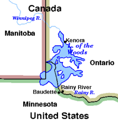
which flows from Lake of the Woods
Lake of the Woods
Lake of the Woods is a lake occupying parts of the Canadian provinces of Ontario and Manitoba and the U.S. state of Minnesota. It separates a small land area of Minnesota from the rest of the United States. The Northwest Angle and the town of Angle Township can only be reached from the rest of...
in the province of Ontario
Ontario
Ontario is a province of Canada, located in east-central Canada. It is Canada's most populous province and second largest in total area. It is home to the nation's most populous city, Toronto, and the nation's capital, Ottawa....
to Lake Winnipeg
Lake Winnipeg
Lake Winnipeg is a large, lake in central North America, in the province of Manitoba, Canada, with its southern tip about north of the city of Winnipeg...
in Manitoba
Manitoba
Manitoba is a Canadian prairie province with an area of . The province has over 110,000 lakes and has a largely continental climate because of its flat topography. Agriculture, mostly concentrated in the fertile southern and western parts of the province, is vital to the province's economy; other...
. This river is 235 kilometres (146 mi) long from the Norman Dam in Kenora to its mouth at Lake Winnipeg. Its watershed
Drainage basin
A drainage basin is an extent or an area of land where surface water from rain and melting snow or ice converges to a single point, usually the exit of the basin, where the waters join another waterbody, such as a river, lake, reservoir, estuary, wetland, sea, or ocean...
is 106500 square kilometres (41,119.9 sq mi) in area, mainly in Canada. About 29000 square kilometres (11,197 sq mi) of this area is in northern Minnesota.
The watershed stretches to the height of land about 100 kilometres (62.1 mi) west of Lake Superior
Lake Superior
Lake Superior is the largest of the five traditionally-demarcated Great Lakes of North America. It is bounded to the north by the Canadian province of Ontario and the U.S. state of Minnesota, and to the south by the U.S. states of Wisconsin and Michigan. It is the largest freshwater lake in the...
. The Winnipeg River watershed was the southeastern-most portion of the land granted to the Hudson's Bay Company
Hudson's Bay Company
The Hudson's Bay Company , abbreviated HBC, or "The Bay" is the oldest commercial corporation in North America and one of the oldest in the world. A fur trading business for much of its existence, today Hudson's Bay Company owns and operates retail stores throughout Canada...
in 1670. The portion in Canada corresponds roughly to the land deeded to Canada in Treaty 3
Treaty 3
Treaty 3 was an agreement entered into on October 3, 1873, by the Ojibway Nation and Queen Victoria. The treaty ceded a vast tract of Ojibway territory, including large parts of what is now northwestern Ontario and a small part of eastern Manitoba, to the Government of Canada...
, signed by Her Majesty's treaty commissioners and the First Nation chiefs at Northwest Angle on the Lake of the Woods in 1873. The river's name means "murky water" in Cree
Cree language
Cree is an Algonquian language spoken by approximately 117,000 people across Canada, from the Northwest Territories and Alberta to Labrador, making it the aboriginal language with the highest number of speakers in Canada. It is also spoken in the U.S. state of Montana...
.
This river route was used by natives for thousands of years and became a major fur trade
Fur trade
The fur trade is a worldwide industry dealing in the acquisition and sale of animal fur. Since the establishment of world market for in the early modern period furs of boreal, polar and cold temperate mammalian animals have been the most valued...
route for hundreds of years. It is the only major water route between what is now southern Manitoba and Ontario that allowed natives to easily canoe
Canoe
A canoe or Canadian canoe is a small narrow boat, typically human-powered, though it may also be powered by sails or small electric or gas motors. Canoes are usually pointed at both bow and stern and are normally open on top, but can be decked over A canoe (North American English) or Canadian...
back and forth. The Red River
Red River of the North
The Red River is a North American river. Originating at the confluence of the Bois de Sioux and Otter Tail rivers in the United States, it flows northward through the Red River Valley and forms the border between the U.S. states of Minnesota and North Dakota before continuing into Manitoba, Canada...
route was much farther south and with a longer portage. La Vérendrye was one of the first explorers to establish fur trade forts near the native camps in the area. The Winnipeg River system through Whiteshell Provincial Park
Whiteshell Provincial Park
Whiteshell Provincial Park is a 2,729 km2 park centrally located in Canada in the province of Manitoba. It can be found in the southeast of the province along the Manitoba-Ontario border, approximately 130 km east of Winnipeg. The park is located in the Canadian Shield region and has many...
has many petroforms near the Whiteshell River
Whiteshell River
Whiteshell River is one of the major rivers in Whiteshell Provincial Park, located in southeastern Manitoba, Canada, near the Ontario border. This river is close to some petroform sites that are about 2000 years old or older...
forks where the two rivers meet. These petroforms are an ancient reminder of the importance of the area for native travel, trade, ceremonies, harvesting, and settlements.
Major modern communities along the banks of the Winnipeg River include: Lac du Bonnet, Pinawa, Powerview, and Pine Falls, all in Manitoba, and Kenora, Minaki and Whitedog in Ontario. Whitedog is the home of the Wabaseemoong First Nation.
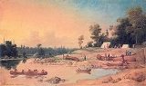
The Winnipeg River became an important transportation route to western Canada for fur traders and explorers. The first Europeans to explore the river are believed to have been the sons of the French explorer La Vérendrye, Jean-Baptiste and Pierre Jr. Extensive travel by canoe and boat continued along the river for hundreds of years until the Canadian Pacific Railway
Canadian Pacific Railway
The Canadian Pacific Railway , formerly also known as CP Rail between 1968 and 1996, is a historic Canadian Class I railway founded in 1881 and now operated by Canadian Pacific Railway Limited, which began operations as legal owner in a corporate restructuring in 2001...
was built across Canada in the late 19th century.
In Manitoba, the Winnipeg River is broken up by six hydroelectric dams
Manitoba Hydro
Manitoba Hydro is the electric power and natural gas utility in the province of Manitoba, Canada. Founded in 1961, it is a provincial Crown Corporation, governed by the Manitoba Hydro-Electric Board and the Manitoba Hydro Act. Today the company operates 15 interconnected generating stations. It has...
: the Pointe du Bois Generating Station at Pointe du Bois, Slave Falls just a few kilometres downstream, Seven Sisters Falls Generating Station at Seven Sisters, MacArthur Falls Generating Station, the Great Falls Generating Station, and the Pine Falls Generating Station at Powerview, Manitoba. In Ontario there are dams at Kenora and Whitedog Falls.
There are also many lakes along the Winnipeg River where the river widens, including Nutimik, Eleanor, Dorothy, Margaret, Natalie, and Lac du Bonnet, all in Manitoba. Nutimik, Dorothy, and Margaret Lakes are all entirely within the Whiteshell Provincial Park
Whiteshell Provincial Park
Whiteshell Provincial Park is a 2,729 km2 park centrally located in Canada in the province of Manitoba. It can be found in the southeast of the province along the Manitoba-Ontario border, approximately 130 km east of Winnipeg. The park is located in the Canadian Shield region and has many...
. Lakes in the Ontario portion of the river include Gun, Roughrock and Sand.
Tributaries include the: Rainy River
Rainy River (Minnesota-Ontario)
The Rainy River is a river, approximately long, which forms part of the U.S.-Canada border separating northern Minnesota and Northwestern Ontario....
, Black Sturgeon River, English River
English River (Ontario)
The English River flows through Lac Seul to join the Winnipeg River. The river is 615 km in length. There are several hydroelectric plants on this river.Tributaries of this river include the Vermilion River and the Wabigoon River...
, Bird River, Lee River, Whiteshell River
Whiteshell River
Whiteshell River is one of the major rivers in Whiteshell Provincial Park, located in southeastern Manitoba, Canada, near the Ontario border. This river is close to some petroform sites that are about 2000 years old or older...
, Whitemouth River
Whitemouth River
The Whitemouth River is located in southeastern Manitoba, Canada. The mouth of the river empties into the Winnipeg River system. The Whitemouth River begins in a remote forested area just north of the border between the United States of America and Canada. Whitemouth Lake feeds the river year...
, and the Mcfarlane River.
Flows on the Winnipeg River are controlled by the Lake of the Woods Control Board which maintains a website with detailed descriptions of the river basin and water flow characteristics.