

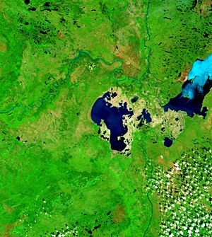
Peace-Athabasca Delta
Encyclopedia
River delta
A delta is a landform that is formed at the mouth of a river where that river flows into an ocean, sea, estuary, lake, reservoir, flat arid area, or another river. Deltas are formed from the deposition of the sediment carried by the river as the flow leaves the mouth of the river...
in northeastern Alberta
Alberta
Alberta is a province of Canada. It had an estimated population of 3.7 million in 2010 making it the most populous of Canada's three prairie provinces...
located where the Peace
Peace River (Canada)
The Peace River is a river in Canada that originates in the Rocky Mountains of northern British Columbia and flows to the northeast through northern Alberta. The Peace River flows into the Slave River, a tributary of the Mackenzie River. The Mackenzie is the 12th longest river in the world,...
and Athabasca River
Athabasca River
The Athabasca River originates from the Columbia Glacier of the Columbia Icefield in Jasper National Park in Alberta, Canada...
s join the Slave River
Slave River
The Slave River is a Canadian river that flows from Lake Athabasca in northeastern Alberta and empties into Great Slave Lake in the Northwest Territories....
at the western end of Lake Athabasca
Lake Athabasca
Lake Athabasca is located in the northwest corner of Saskatchewan and the northeast corner of Alberta between 58° and 60° N.-History:The name in the Dene language originally referred only to the large delta formed by the confluence the Athabasca River at the southwest corner of the lake...
.
Conservation
The marshMarsh
In geography, a marsh, or morass, is a type of wetland that is subject to frequent or continuous flood. Typically the water is shallow and features grasses, rushes, reeds, typhas, sedges, other herbaceous plants, and moss....
es, lakes and mud flats of this area are an important habitat for waterfowl nesting and provides a staging area for migration
Bird migration
Bird migration is the regular seasonal journey undertaken by many species of birds. Bird movements include those made in response to changes in food availability, habitat or weather. Sometimes, journeys are not termed "true migration" because they are irregular or in only one direction...
. As many as one million duck
Duck
Duck is the common name for a large number of species in the Anatidae family of birds, which also includes swans and geese. The ducks are divided among several subfamilies in the Anatidae family; they do not represent a monophyletic group but a form taxon, since swans and geese are not considered...
s, geese
Goose
The word goose is the English name for a group of waterfowl, belonging to the family Anatidae. This family also includes swans, most of which are larger than true geese, and ducks, which are smaller....
and swan
Swan
Swans, genus Cygnus, are birds of the family Anatidae, which also includes geese and ducks. Swans are grouped with the closely related geese in the subfamily Anserinae where they form the tribe Cygnini. Sometimes, they are considered a distinct subfamily, Cygninae...
s pass through this area in the fall. The grass and sedge meadows of this area provide habitat for several thousand Wood and Plains Buffalo
Bison
Members of the genus Bison are large, even-toed ungulates within the subfamily Bovinae. Two extant and four extinct species are recognized...
. The endangered Whooping Crane
Whooping Crane
The whooping crane , the tallest North American bird, is an endangered crane species named for its whooping sound. Along with the Sandhill Crane, it is one of only two crane species found in North America. The whooping crane's lifespan is estimated to be 22 to 24 years in the wild...
migrates through the delta on its way to its nearby nesting area.
Much of this area falls inside Wood Buffalo National Park
Wood Buffalo National Park
Wood Buffalo National Park, located in northeastern Alberta and southern Northwest Territories, is the largest national park in Canada at . The park was established in 1922 to protect the world's largest herd of free roaming Wood Bison, currently estimated at more than 5,000...
. This delta was recognized on 24 May 1982 as a wetland of international significance under the Ramsar Convention
Ramsar Convention
The Ramsar Convention is an international treaty for the conservation and sustainable utilization of wetlands, i.e., to stem the progressive encroachment on and loss of wetlands now and in the future, recognizing the fundamental ecological functions of wetlands and their economic, cultural,...
, for its undisturbed nature and for being the largest boreal
Boreal ecosystem
The term boreal is usually applied to ecosystems localized in subarctic and subantarctic zones, although Austral is also used for the latter....
delta of the world.
Influence of Bennett Dam
In the late 1960s, the W.A.C. Bennett Dam was constructed on the Peace River in northern British ColumbiaBritish Columbia
British Columbia is the westernmost of Canada's provinces and is known for its natural beauty, as reflected in its Latin motto, Splendor sine occasu . Its name was chosen by Queen Victoria in 1858...
by BC Hydro
BC Hydro
The BC Hydro and Power Authority is a Canadian electric utility in the province of British Columbia generally known simply as BC Hydro. It is the main electric distributor, serving 1.8 million customers in most areas, with the exception of the Kootenay region, where FortisBC, a subsidiary of Fortis...
, a major hydropower utility. The role of the dam has been disputed. Initial drops in water levels were mitigated by the construction of three rock-fill weirs on the Chenal des Quatre Forches, Revillon Coupé, and Riviere des Rochers, the first of which was later removed due to complaints from muskrat trappers. The weirs restored mean open-season water levels nearly to pre-regulation levels.
Critical to the delta are spring ice-jam floods that play a critical role in refilling perched basins and wetlands outside of the permanently connected channels and lakes. It has been claimed that the dam reduced ice-jam floods, but the recent studies are not able to verify this claim. Sediment records were used to reconstruct the history of flooding for the past 300 years. Maximum flood frequency was seen to reach a maximum in the early 1900s and declined in the 1940s and 1950s prior to the construction of the dam. Between 1975 and 1995 there were no major ice-jam floods and this could be a result of the dam. In 1996 and 1997 major ice-jam floods occurred. There have been similar prolonged periods lacking major flooding including 1813 - 1839 and 1705 - 1786.
Studies of the climate and ecology of the Peace–Athabasca Delta have been carried out to understand the effect of the dam on delta. It was found that the recent decades are neither the driest nor the wettest that the delta has experienced in the past three hundred years. The early 1900s were some of the wettest conditions experienced by the delta and during the early- to mid-1900s there has been a general trend of drying. While the delta is drier today than it was in the early parts of the 1900s, there is no clear indication that the dam is responsible. The Peace-Athabasca is still well within the range of naturally variability due to natural changes in climate seen within the past few centuries.
An ongoing lawsuit between BC Hydro and local First Nations bands relates to the effects of Bennett Dam on Delta water levels and associated traditional lifestyles.
Waterways
The Birch River flows into Lake ClaireLake Claire (Alberta)
Lake Claire is the largest lake which is entirely in Alberta, Canada. It is located entirely in Wood Buffalo National Park, west of Lake Athabasca. It lies between the mouths of Peace River and Athabasca River, and is part of the Peace-Athabasca Delta system....
, the largest lake completely in Alberta, which is an important part of the delta. Other lakes located in the delta are Baril Lake, Mamawi Lake, Hilda Lake, Otter Lake, French Lake, Pair Lakes, Welstead Lake, Four Forks Lake, Galoot Lake, Pushup Lake, Jemis Lake, Richardson Lake, Flett Lake, Blanche Lake and Limon Lake.
Revillon Coupé, Riviere des Rochers and Chenal des Quatre Fourches are the main distributaries connecting Lake Athabasca and the point where Peace River flows into the Slave River. When the Peace River is in flood, the flow of these channels are reversed and water from the Peace flows into Lake Athabasca.
Other rivers draining the wetlands through the Peace–Athabasca Delta include Swift Current Creek, Carolyn Creek, Modere Creek, Steepbank River, McIvor River, Buckton Creek, Frog Creek, Sall River, Bolton Creek, Edra Creek, Peel Creek, Alice Creek, Mamawi Creek, Embarras River, Horse Island Creek, Chilloneys Creek, Claire River, Dempsey Creek, Baril River, Peltier Creek, Scow Channel, Powder Creek, and Revillon Coupe.
External links
- Peace-Athabasca Delta, Geographical Names of Canada