
Great Slave Lake
Encyclopedia
Great Slave Lake is the second-largest lake
in the Northwest Territories
of Canada
(after Great Bear Lake
), the deepest lake in North America
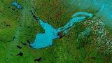
at 614 m (335.7 fathom; 2,014.4 ft), and the ninth-largest lake in the world. It is 480 kilometres (298.3 mi) long and 19 to 109 km (11.8 to 67.7 ) wide. It covers an area of 27200 square kilometres (10,502 sq mi) in the southern part of the territory. Its given volume ranges from 1070 cubic kilometres (256.7 cu mi) to 1580 km³ (379.1 cu mi) and up to 2088 km³ (500.9 cu mi) making it the 10th or 12th largest. The lake shares its name with the Slavey First Nations
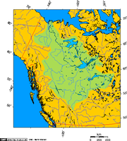
. Towns situated on the lake include: Yellowknife, Hay River
, Behchoko, Fort Resolution, Lutselk'e, Hay River Reserve
, Dettah and N'Dilo
. The only community in the East Arm is Lutselk'e, a hamlet of about 350 people, largely Chipewyan
Aboriginals of the Dene
Nation and the now abandoned winter camp/Hudson's Bay Company
post, Fort Reliance
.
fur trade
r Samuel Hearne
explored the area in 1771 and crossed the frozen lake, which he initially named Lake Athapuscow (after an erroneous French speaker's pronunciation of Athabaska). In 1897-1898, the American frontiersman Charles "Buffalo" Jones
traveled to the Arctic Circle
, where his party wintered in a cabin that they had constructed near the Great Slave Lake. Jones's exploits of how he and his party shot and fended off a hungry wolf
pack near Great Slave Lake was verified in 1907 by Ernest Thompson Seton
and Edward Alexander Preble
when they discovered the remains of the animals near the long abandoned cabin.
In the 1930s, gold
was discovered there, which led to the establishment of Yellowknife, which would become the capital of the NWT
. In 1967, an all-season highway was built around the lake, originally an extension of the Mackenzie Highway
but now known as Yellowknife Highway
or Highway 3. On January 24, 1978, a Soviet
Radar Ocean Reconnaissance Satellite
, named Kosmos 954, built with an on board nuclear reactor fell from orbit and disintegrated. Pieces of the nuclear core fell in the vicinity of Great Slave Lake. 90% of the nuclear debris was recovered by a group called Operation Morning Light formed with both American
and Canadian members.
 The Hay
, Slave
and Taltson River
s are its chief tributaries. It is drained by the Mackenzie River
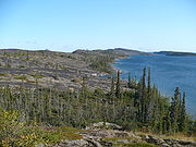
. Though the western shore is forested, the east shore and northern arm are tundra
-like. The southern and eastern shores reach the edge of the Canadian Shield
. Along with other lakes such as the Great Bear and Athabasca
, it is a remnant of a vast post-glacial lake
.
The East Arm of Great Slave Lake is filled with islands, and the area is within Thaydene Nene National Park
. The Pethei Peninsula separates the East Arm into McLeod Bay in the north and Christie Bay in the south. The lake is at least partially frozen during an average of eight months of the year. During winter, the ice is thick enough for semi-trailer truck
s to pass over using ice road
s. Until 1967, when an all-season highway was built around the lake, goods were shipped across the ice to Yellowknife, located on the north shore. Goods and fuel are still shipped across frozen lakes up the winter road
to the diamond mines located near the headwaters of the Coppermine River
, Northwest Territories. A ferry is required to reach Yellowknife when the ice is not present in a solid sheet along Highway 3 where it crosses the Mackenzie River. The ferry usually runs from mid-May until January with a three to four week period (from mid-April to mid-May) between the closing of the ice road and the start of ferry service. However, the expected completion of the Deh Cho Bridge
across the Mackenzie in 2011 is expected to end the need for the ferry.
The main western portion of the lake forms a moderately deep bowl with a surface area of 18500 km² (7,142.9 sq mi) and a volume of 596 km³ (143 cu mi). This main portion has a maximum depth of 187.7 m (615.8 ft) and a mean depth of 32.2 m (105.6 ft). To the east, McLeod Bay (62°52′N 110°10′W) and Christie Bay (62°32′N 111°00′W) are much deeper, with a maximum recorded depth in Christie Bay of 614 m (2,014.4 ft).
On some of the plains surrounding Great Slave Lake, climax
polygonal bog
s have formed, the early successional stage to which often consists of pioneer Black Spruce.
South of Great Slave Lake, in a remote corner of Wood Buffalo National Park
, is the nesting site of a remnant flock of Whooping Crane
s, discovered in 1954.
Lake
A lake is a body of relatively still fresh or salt water of considerable size, localized in a basin, that is surrounded by land. Lakes are inland and not part of the ocean and therefore are distinct from lagoons, and are larger and deeper than ponds. Lakes can be contrasted with rivers or streams,...
in the Northwest Territories
Northwest Territories
The Northwest Territories is a federal territory of Canada.Located in northern Canada, the territory borders Canada's two other territories, Yukon to the west and Nunavut to the east, and three provinces: British Columbia to the southwest, and Alberta and Saskatchewan to the south...
of Canada
Canada
Canada is a North American country consisting of ten provinces and three territories. Located in the northern part of the continent, it extends from the Atlantic Ocean in the east to the Pacific Ocean in the west, and northward into the Arctic Ocean...
(after Great Bear Lake
Great Bear Lake
Great Bear Lake is the largest lake entirely within Canada , the third or fourth largest in North America, and the seventh or eighth largest in the world...
), the deepest lake in North America
North America
North America is a continent wholly within the Northern Hemisphere and almost wholly within the Western Hemisphere. It is also considered a northern subcontinent of the Americas...
at 614 m (335.7 fathom; 2,014.4 ft), and the ninth-largest lake in the world. It is 480 kilometres (298.3 mi) long and 19 to 109 km (11.8 to 67.7 ) wide. It covers an area of 27200 square kilometres (10,502 sq mi) in the southern part of the territory. Its given volume ranges from 1070 cubic kilometres (256.7 cu mi) to 1580 km³ (379.1 cu mi) and up to 2088 km³ (500.9 cu mi) making it the 10th or 12th largest. The lake shares its name with the Slavey First Nations
First Nations
First Nations is a term that collectively refers to various Aboriginal peoples in Canada who are neither Inuit nor Métis. There are currently over 630 recognised First Nations governments or bands spread across Canada, roughly half of which are in the provinces of Ontario and British Columbia. The...
. Towns situated on the lake include: Yellowknife, Hay River
Hay River, Northwest Territories
Hay River , known as "the Hub of the North," is a town in the Northwest Territories, Canada, located on the south shore of Great Slave Lake, at the mouth of the Hay River. The town is separated into two sections, a new town and an old town with the Hay River Airport between them...
, Behchoko, Fort Resolution, Lutselk'e, Hay River Reserve
Hay River Reserve
Hay River Reserve is the only Indian reserve in Canada's Northwest Territories. Located in the South Slave Region, it is a Slavey community with a population of 309 as of the 2006 census. The main languages on the reserve are South Slavey, Chipewyan and English...
, Dettah and N'Dilo
N'Dilo
N'Dilo is a First Nations community in the North Slave Region of the Northwest Territories, Canada. The small Dene community is located on the edge of Yellowknife on the tip of Latham Island.It has a population of approximately 200 people...
. The only community in the East Arm is Lutselk'e, a hamlet of about 350 people, largely Chipewyan
Chipewyan
The Chipewyan are a Dene Aboriginal people in Canada, whose ancestors were the Taltheilei...
Aboriginals of the Dene
Dene
The Dene are an aboriginal group of First Nations who live in the northern boreal and Arctic regions of Canada. The Dené speak Northern Athabaskan languages. Dene is the common Athabaskan word for "people" . The term "Dene" has two usages...
Nation and the now abandoned winter camp/Hudson's Bay Company
Hudson's Bay Company
The Hudson's Bay Company , abbreviated HBC, or "The Bay" is the oldest commercial corporation in North America and one of the oldest in the world. A fur trading business for much of its existence, today Hudson's Bay Company owns and operates retail stores throughout Canada...
post, Fort Reliance
Fort Reliance, Northwest Territories
Fort Reliance is located on the east arm of Great Slave Lake, Northwest Territories, Canada. It was originally built in 1833 by George Back during the Arctic Land Expedition to the Arctic Ocean via the Back River...
.
History
North American Aboriginal Peoples were the first settlers around the lake, building communities including Dettah, which still exists today. BritishKingdom of Great Britain
The former Kingdom of Great Britain, sometimes described as the 'United Kingdom of Great Britain', That the Two Kingdoms of Scotland and England, shall upon the 1st May next ensuing the date hereof, and forever after, be United into One Kingdom by the Name of GREAT BRITAIN. was a sovereign...
fur trade
Fur trade
The fur trade is a worldwide industry dealing in the acquisition and sale of animal fur. Since the establishment of world market for in the early modern period furs of boreal, polar and cold temperate mammalian animals have been the most valued...
r Samuel Hearne
Samuel Hearne
Samuel Hearne was a an English explorer, fur-trader, author, and naturalist. He was the first European to make an overland excursion across northern Canada to the Arctic Ocean, actually Coronation Gulf, via the Coppermine River...
explored the area in 1771 and crossed the frozen lake, which he initially named Lake Athapuscow (after an erroneous French speaker's pronunciation of Athabaska). In 1897-1898, the American frontiersman Charles "Buffalo" Jones
Charles "Buffalo" Jones
Charles Jesse Jones, known as Buffalo Jones , was an American frontiersman, farmer, rancher, hunter, and conservationist who cofounded Garden City, Kansas...
traveled to the Arctic Circle
Arctic Circle
The Arctic Circle is one of the five major circles of latitude that mark maps of the Earth. For Epoch 2011, it is the parallel of latitude that runs north of the Equator....
, where his party wintered in a cabin that they had constructed near the Great Slave Lake. Jones's exploits of how he and his party shot and fended off a hungry wolf
Gray Wolf
The gray wolf , also known as the wolf, is the largest extant wild member of the Canidae family...
pack near Great Slave Lake was verified in 1907 by Ernest Thompson Seton
Ernest Thompson Seton
Ernest Thompson Seton was a Scots-Canadian who became a noted author, wildlife artist, founder of the Woodcraft Indians, and one of the founding pioneers of the Boy Scouts of America . Seton also influenced Lord Baden-Powell, the founder of Scouting...
and Edward Alexander Preble
Edward Alexander Preble
Edward Alexander Preble was an American naturalist and conservationist. He is noted for work in studying birds and mammals of the Pacific Northwest...
when they discovered the remains of the animals near the long abandoned cabin.
In the 1930s, gold
Gold
Gold is a chemical element with the symbol Au and an atomic number of 79. Gold is a dense, soft, shiny, malleable and ductile metal. Pure gold has a bright yellow color and luster traditionally considered attractive, which it maintains without oxidizing in air or water. Chemically, gold is a...
was discovered there, which led to the establishment of Yellowknife, which would become the capital of the NWT
History of Northwest Territories capital cities
The history of Northwest Territories capital cities begins with the purchase of the Territories by Canada from the Hudson's Bay Company in 1869 and includes a varied and often difficult evolution. Northwest Territories is unique amongst the other provinces and territories of Canada in that it has...
. In 1967, an all-season highway was built around the lake, originally an extension of the Mackenzie Highway
Mackenzie Highway
The Mackenzie Highway is a Canadian highway in northern Alberta and the Northwest Territories. It begins as Alberta Highway 2 at Mile Zero in Grimshaw, Alberta...
but now known as Yellowknife Highway
Yellowknife Highway
Highway 3, known more commonly as the Yellowknife Highway, but also the Great Slave Highway, connects Yellowknife, Northwest Territories to Highway 1, from a junction north of the Alberta border. Built in 1968, the highway is now completely paved and realigned after years of work concluded in...
or Highway 3. On January 24, 1978, a Soviet
Soviet Union
The Soviet Union , officially the Union of Soviet Socialist Republics , was a constitutionally socialist state that existed in Eurasia between 1922 and 1991....
Radar Ocean Reconnaissance Satellite
RORSAT
Radar Ocean Reconnaissance SATellite or RORSAT is the western name given to the Soviet Upravlyaemyj Sputnik Aktivnyj satellites. These satellites were launched between 1967 and 1988 to monitor NATO and merchant vessels using active radar...
, named Kosmos 954, built with an on board nuclear reactor fell from orbit and disintegrated. Pieces of the nuclear core fell in the vicinity of Great Slave Lake. 90% of the nuclear debris was recovered by a group called Operation Morning Light formed with both American
United States
The United States of America is a federal constitutional republic comprising fifty states and a federal district...
and Canadian members.
Geography and natural history
Hay River (Canada)
Hay River is a large river in northern Alberta and southern Northwest Territories, Canada.It originates in the muskeg of north western Alberta, flows west to British Columbia, then returns to Alberta, where it follows a northern course towards the Northwest Territories, where it discharges in the...
, Slave
Slave River
The Slave River is a Canadian river that flows from Lake Athabasca in northeastern Alberta and empties into Great Slave Lake in the Northwest Territories....
and Taltson River
Taltson River
The Taltson River is a roughly river in the Northwest Territories of Canada. It flows into the Great Slave Lake and ultimately reaches the Beaufort Sea through the Mackenzie River. Eight reservoirs, Nonacho, Taltson, King, Lady Grey, Benna Thy, Kozo, Twin Gorges, and Tsu, impound the river to...
s are its chief tributaries. It is drained by the Mackenzie River
Mackenzie River
The Mackenzie River is the largest river system in Canada. It flows through a vast, isolated region of forest and tundra entirely within the country's Northwest Territories, although its many tributaries reach into four other Canadian provinces and territories...
. Though the western shore is forested, the east shore and northern arm are tundra
Tundra
In physical geography, tundra is a biome where the tree growth is hindered by low temperatures and short growing seasons. The term tundra comes through Russian тундра from the Kildin Sami word tūndâr "uplands," "treeless mountain tract." There are three types of tundra: Arctic tundra, alpine...
-like. The southern and eastern shores reach the edge of the Canadian Shield
Canadian Shield
The Canadian Shield, also called the Laurentian Plateau, or Bouclier Canadien , is a vast geological shield covered by a thin layer of soil that forms the nucleus of the North American or Laurentia craton. It is an area mostly composed of igneous rock which relates to its long volcanic history...
. Along with other lakes such as the Great Bear and Athabasca
Lake Athabasca
Lake Athabasca is located in the northwest corner of Saskatchewan and the northeast corner of Alberta between 58° and 60° N.-History:The name in the Dene language originally referred only to the large delta formed by the confluence the Athabasca River at the southwest corner of the lake...
, it is a remnant of a vast post-glacial lake
Glacial lake
A glacial lake is a lake with origins in a melted glacier. Near the end of the last glacial period, roughly 10,000 years ago, glaciers began to retreat. A retreating glacier often left behind large deposits of ice in hollows between drumlins or hills. As the ice age ended, these melted to create...
.
The East Arm of Great Slave Lake is filled with islands, and the area is within Thaydene Nene National Park
Thaydene Nene National Park
Thaydene Nene National Park is a proposed national park located on the northern edge of the boreal forest in the Northwest Territories, Canada...
. The Pethei Peninsula separates the East Arm into McLeod Bay in the north and Christie Bay in the south. The lake is at least partially frozen during an average of eight months of the year. During winter, the ice is thick enough for semi-trailer truck
Semi-trailer truck
A semi-trailer truck, also known as a semi, tractor-trailer, or articulated truck or articulated lorry, is an articulated vehicle consisting of a towing engine , and a semi-trailer A semi-trailer truck, also known as a semi, tractor-trailer, or (in the United Kingdom and Ireland) articulated truck...
s to pass over using ice road
Ice road
Ice roads are frozen, human-made structures on the surface of bays, rivers, lakes, or seas in the far north. They link dry land, frozen waterways, portages and winter roads, and are usually remade each winter. Ice roads allow temporary transport to areas with no permanent road access...
s. Until 1967, when an all-season highway was built around the lake, goods were shipped across the ice to Yellowknife, located on the north shore. Goods and fuel are still shipped across frozen lakes up the winter road
Winter road
Winter roads are temporary highways carved out of snow and ice. They facilitate transportation to and from communities without permanent roads, and are commonly seen in isolated regions in Canada's north....
to the diamond mines located near the headwaters of the Coppermine River
Coppermine River
The Coppermine River is a river in the North Slave and Kitikmeot regions of the Northwest Territories and Nunavut in Canada. It is long. It rises in Lac de Gras, a small lake near Great Slave Lake and flows generally north to Coronation Gulf, an arm of the Arctic Ocean...
, Northwest Territories. A ferry is required to reach Yellowknife when the ice is not present in a solid sheet along Highway 3 where it crosses the Mackenzie River. The ferry usually runs from mid-May until January with a three to four week period (from mid-April to mid-May) between the closing of the ice road and the start of ferry service. However, the expected completion of the Deh Cho Bridge
Deh Cho Bridge
The Deh Cho Bridge, currently under construction since 2008, will be a bridge across a span of the Mackenzie River on Highway 3 near Fort Providence, Northwest Territories, Canada...
across the Mackenzie in 2011 is expected to end the need for the ferry.
The main western portion of the lake forms a moderately deep bowl with a surface area of 18500 km² (7,142.9 sq mi) and a volume of 596 km³ (143 cu mi). This main portion has a maximum depth of 187.7 m (615.8 ft) and a mean depth of 32.2 m (105.6 ft). To the east, McLeod Bay (62°52′N 110°10′W) and Christie Bay (62°32′N 111°00′W) are much deeper, with a maximum recorded depth in Christie Bay of 614 m (2,014.4 ft).
On some of the plains surrounding Great Slave Lake, climax
Climax community
In ecology, a climax community, or climatic climax community, is a biological community of plants and animals which, through the process of ecological succession — the development of vegetation in an area over time — has reached a steady state. This equilibrium occurs because the climax community...
polygonal bog
Patterned ground
Patterned ground is a term used to describe the distinct, and often symmetrical geometric shapes formed by ground material in periglacial regions...
s have formed, the early successional stage to which often consists of pioneer Black Spruce.
South of Great Slave Lake, in a remote corner of Wood Buffalo National Park
Wood Buffalo National Park
Wood Buffalo National Park, located in northeastern Alberta and southern Northwest Territories, is the largest national park in Canada at . The park was established in 1922 to protect the world's largest herd of free roaming Wood Bison, currently estimated at more than 5,000...
, is the nesting site of a remnant flock of Whooping Crane
Whooping Crane
The whooping crane , the tallest North American bird, is an endangered crane species named for its whooping sound. Along with the Sandhill Crane, it is one of only two crane species found in North America. The whooping crane's lifespan is estimated to be 22 to 24 years in the wild...
s, discovered in 1954.
Ice road
There is one ice road on Great Slave Lake, the Dettah ice road, which connects from Yellowknife, the capital of the Northwest Territories to Dettah, also in the Northwest Territories.See also
- List of lakes of Canada