

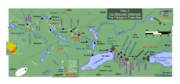
Fox-Wisconsin Waterway
Encyclopedia
Waterway
A waterway is any navigable body of water. Waterways can include rivers, lakes, seas, oceans, and canals. In order for a waterway to be navigable, it must meet several criteria:...
formed by the Fox
Fox River (Wisconsin)
The Fox River is a river in eastern and central Wisconsin in the United States. Along the banks is a chain of cities, including Oshkosh, Neenah, Menasha, Appleton, Little Chute, Kimberly, Combined Locks, and Kaukauna. Except for Oshkosh, these cities refer to themselves as the Fox Cities...
and Wisconsin River
Wisconsin River
-External links:* * * , Wisconsin Historical Society* * * *...
s. First used by European settlers in 1673 during the expedition of Marquette
Jacques Marquette
Father Jacques Marquette S.J. , sometimes known as Père Marquette, was a French Jesuit missionary who founded Michigan's first European settlement, Sault Ste. Marie, and later founded St. Ignace, Michigan...
& Joliet, it was one of the principal routes used by travelers between the Great Lakes and the Mississippi River
Mississippi River
The Mississippi River is the largest river system in North America. Flowing entirely in the United States, this river rises in western Minnesota and meanders slowly southwards for to the Mississippi River Delta at the Gulf of Mexico. With its many tributaries, the Mississippi's watershed drains...
until the completion of the Illinois and Michigan Canal
Illinois and Michigan Canal
The Illinois and Michigan Canal ran from the Bridgeport neighborhood in Chicago on the Chicago River to LaSalle-Peru, Illinois, on the Illinois River. It was finished in 1848 when Chicago Mayor James Hutchinson Woodworth presided over its opening; and it allowed boat transportation from the Great...
in 1848 and the arrival of railroads. The western terminus of the Fox–Wisconsin Waterway was at the Mississippi at Prairie du Chien, Wisconsin
Prairie du Chien, Wisconsin
Prairie du Chien is a city in and the county seat of Crawford County, Wisconsin, United States. The population was 5,911 at the 2010 census. Its Zip Code is 53821....
. It continued up the Wisconsin River about 116 miles (187 km) until reaching Portage, Wisconsin
Portage, Wisconsin
Portage is a city in and the county seat of Columbia County, Wisconsin, United States. The population was 10,662 at the 2010 census making it the largest city in Columbia County...
. There travelers would portage to the Upper Fox River, or eventually, use the Portage Canal. It continued about 160 miles (257 km) down the Fox River, following it through Lake Winnebago
Lake Winnebago
Lake Winnebago is a freshwater lake in eastern Wisconsin, United States. It is the largest lake entirely within the state.-Statistics:...
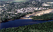
and continuing on the Lower Fox over 170 feet (50 m) of falls to the eastern terminus of Green Bay.
In the mid-19th century, the waterway was improved with numerous locks, dams and canals, including the 2-mile (3 km) Portage Canal between the Fox and Wisconsin Rivers. All the locks were not completed until 1876, well after the Illinois and Michigan Canal and at the point where the move from canals to railroads was in full swing. Later development on the waterway introduced barriers to navigation, such as the dam at Prairie du Sac. Use of the waterway was never substantial and it slowly died out. The Portage Canal was closed in 1951 and most of the Upper Fox River locks and dams fell into disuse. The lock system on the Lower Fox River, from Lake Winnebago to Green Bay, was closed in 1983 to prevent the upstream spread of invasive species such as the lamprey.
The Fox-Wisconsin is no longer used as a transportation route between the Mississippi River and the Great Lakes. However, the various reaches of the waterway enjoy significant recreational use. Plans are well advanced for reopening the Lower Fox locks and dams.
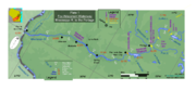
Reaches
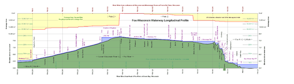
The Waterway can be divide into four physical reaches: the Lower Wisconsin River, “The Portage” canal and locks at Portage, the Upper Fox River and the Lower Fox River.Physical description
Overall the system is about 280 mile long. It begins in the west at the Mississippi River, rises at a nearly constant rate to Portage, crosses the Great-Lakes/Mississippi River divide at Portage, descends slowly along the Upper Fox to the Lake Winnebago PoolWinnebago Pool
The Winnebago Pool is a collective name for a group of interconnected lakes in eastern Wisconsin. The terminal point of this watershed is Lake Winnebago itself, which has a surface elevation of 746 feet. Besides Lake Winnebago, the Winnebago Pool includes Big Lake Butte des Morts, Lake Poygan and...
and then plunges in a short reach to the eastern end at the head of Green Bay on Lake Michigan.
Lower Wisconsin
The lower Wisconsin River flows through glacial drift until it enters the Driftless Area and eventually reaches the Mississippi River. It extends about 116 river miles (187 river kilometers) from Portage to its confluence with the Mississippi River, falling 171 feet (52 m) from about elevation 782 feet (238 m) above sea level (msl) at Portage to 611 feet (186 m), msl at the Mississippi.The reach has nearly uniform hydraulic gradient of about 1.5 feet per mile (0.3 m/km). There is only one major tributary, the Kickapoo River, which enters just before the Mississippi at about River Mile 16 (River km 26). Since there are no major tributaries, river discharge in the reach are relatively constant, averaging about 8700 cuft/s at USGS gage 05407000 at Muscoda.
The river channel is dominated by sand. Sand bars, tow-head islands and new, multiple channels form often and constantly change. The channel is wide and shallow.
The Portage
The 2-mile (3 km) portage at Portage, Wisconsin is not unique as a passage between the Great Lakes and Mississippi River watersheds. Similar passages exist all along the watershed divide, for instance, at ChicagoChicago
Chicago is the largest city in the US state of Illinois. With nearly 2.7 million residents, it is the most populous city in the Midwestern United States and the third most populous in the US, after New York City and Los Angeles...
and in the northern Indiana area.. What is unique is that, while the Fox is a small stream—typical of such passages—the Wisconsin is a large river, already over 300 miles (500 km) long. The divide between the two rivers has little grade change, although it is marshy. The Wisconsin occasionally flowed across the Portage into the Fox during high water. The Fox and Wisconsin have modified their courses and outlets over geological time and it is likely that either river has flowed into either watershed. Only about 2 miles (3 km) separate the two rivers. The Fox River end of the canal is at about elevation 780 feet (238 m) msl. The Wisconsin River end is slightly higher, depending on Wisconsin River discharge levels.
The Portage lies about 116 river miles (187 km) from the Mississippi River and 162 river miles (261 km) from Green Bay.
Upper Fox
The upper Fox River flows northwest from its headwater to within 2 miles (3 km) the Portage. It then flows to the north-northeast to the Lake Winnebago Pool. It extends about 110 river miles (177 km) from Portage to Lake Winnebago, falling only about 36 feet (11 m) from elevation 782 feet (238 m), msl at the Portage to 746 feet (227 m), msl at Lake Winnebago.The reach has a shallow grade. The hydraulic gradient averages about 4 inches per mile (0.06 m/km). There are two very shallow lakes along the way, Buffalo Lake and Lake Puckaway. The river drainage area grows significantly in size from 80 square miles (207.2 km²) at the Portage to about 1340 square miles (3,470.6 km²) at USGS gage 004073500 at Berlin, where the average flow is about 1140 cuft/s. The river discharge would grow at nearly the same proportions. Thus the Upper Fox grows from a small stream to a small river over its course. At Big Lake Butte des Morts
Lake Butte des Morts
Big Lake Butte des Morts is an lake located in the U.S. state of Wisconsin and is part of the Winnebago Pool . The lake is fed by the Fox River in the southwest and the Wolf River draining from Lake Winneconne in the northwest, and drains via the Fox River southeast into Lake Winnebago...
it is joined from the north by flow from the Wolf River through Lake Poygan. The drainage area of Wolf River is more than twice the size of the drainage area of the Fox. But this extra flow joins the Fox only after it reaches the Lake Winnebago Pool.
The river channel is characterized by sand, silt and organic material. The channel, which ranges from 70 foot, is shallow and generally widens and deepens as it approaches Lake Winnebago.
Lower Fox
The lower Fox River flows from the natural impoundment of Lake Winnebago to Lake Michigan. It extends about 39 river miles (63 km) from Menasha at the head of Lake Winnebago to Lake Michigan , falling 169 feet (52 m) from about elevation 746 feet (227 m), msl at Winnebago to 577 feet (176 m), msl at Green Bay. The reach has a very steep and changing grade. While the hydraulic gradient averages about 4 feet per mile (0.75 m/km), there are very large falls at (using the original French nomenclature) La Grand Kaukilin (Kaukauna), La Petite Chute (Little Chute) and La Grand Chute (Appleton). The total drop of these falls is approximately the same as Niagara FallsNiagara Falls
The Niagara Falls, located on the Niagara River draining Lake Erie into Lake Ontario, is the collective name for the Horseshoe Falls and the adjacent American Falls along with the comparatively small Bridal Veil Falls, which combined form the highest flow rate of any waterfalls in the world and has...
, although over a much longer stretch.
There are no major tributaries. Thus the river discharge is nearly constant, averaging about 4600 cuft/s at USGS gage 040851385 at Green Bay.
History prior to modifications
The reach served as highway for Native American peoples and, later, European explorers. Historic Indians and later European explorers and fur traders of the Upper Mississippi Valley used the Fox and Wisconsin rivers as a primary highway between the Great Lakes and Mississippi River. In fact, it was the most heavily traveled of all the portages between the Great Lakes and Mississippi watersheds. From the Portage, one could travel north to nearly Lake Superior along the Upper Wisconsin, west to the Mississippi along the Lower Wisconsin or northeast along the Fox to Lake Michigan. Other watersheds, such as the Wolf River to north central Wisconsin or the Rock River to the IllinoisIllinois
Illinois is the fifth-most populous state of the United States of America, and is often noted for being a microcosm of the entire country. With Chicago in the northeast, small industrial cities and great agricultural productivity in central and northern Illinois, and natural resources like coal,...
country, were within easy distance.
In the 17th century the area was dominated by a number of tribes, Ho Chunk (Winnebago), Menominee
Menominee
Some placenames use other spellings, see also Menomonee and Menomonie.The Menominee are a nation of Native Americans living in Wisconsin. The Menominee, along with the Ho-Chunk, are the only tribes that are indigenous to what is now Wisconsin...
, Kickapoo and Chippewa tribes among them. Pressures from the French colonization of the eastern St Lawrence River and Great Lakes
Great Lakes
The Great Lakes are a collection of freshwater lakes located in northeastern North America, on the Canada – United States border. Consisting of Lakes Superior, Michigan, Huron, Erie, and Ontario, they form the largest group of freshwater lakes on Earth by total surface, coming in second by volume...
region eventually forced Fox and Sac tribes to the region, displacing the original tribes. The Fox and Sac, realizing the importance of the Waterway, essentially set up toll stations at various portage locations. The French, resentful of lost trade, engaged the Fox in a series of wars known as the Fox Wars
Fox Wars
The Fox Wars were two 18th-century wars between the Fox Indians and the French , which occurred in territories that are now the states of Michigan and Wisconsin, U.S.A.. The First Fox War broke out with the French when the Fox numbered some 3,500. After the Second Fox War , the remaining 1,500...
. The Fox were not driven totally displaced from the Waterway until 1832, when American troops forced them out during the Blackhawk War.
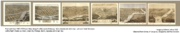
Among the Europeans, French traders dominated the Waterway. They set up forts or settlements at La Baye (Green Bay), Portage (eventually Fort Winnebago) and Prairie du Chien . Their influence is apparent from the remaining place names and features, Prairie du Chien, Portage, DePere, and Lake Butte des Morts to name a few. In fact property in parts of Prairie du Chien, Portage, Kaukauna and Green Bay, all along the Waterway, still use French long-lot descriptions. All four cities are among the oldest in Wisconsin and the region.
The earliest French explorers were Father Marquette and Joliet in the summer of 1673. The French were to control the area for roughly 100 years until the end of the French and Indian War
French and Indian War
The French and Indian War is the common American name for the war between Great Britain and France in North America from 1754 to 1763. In 1756, the war erupted into the world-wide conflict known as the Seven Years' War and thus came to be regarded as the North American theater of that war...
. The British officially controlled the area until the end of the American Revolutionary war
American Revolutionary War
The American Revolutionary War , the American War of Independence, or simply the Revolutionary War, began as a war between the Kingdom of Great Britain and thirteen British colonies in North America, and ended in a global war between several European great powers.The war was the result of the...
and nominally until the end of the War of 1812
War of 1812
The War of 1812 was a military conflict fought between the forces of the United States of America and those of the British Empire. The Americans declared war in 1812 for several reasons, including trade restrictions because of Britain's ongoing war with France, impressment of American merchant...
, after which the American government was in firm control.
Modifications
The arrival of steamships to the region and the success of eastern canal systems, especially the Erie CanalErie Canal
The Erie Canal is a waterway in New York that runs about from Albany, New York, on the Hudson River to Buffalo, New York, at Lake Erie, completing a navigable water route from the Atlantic Ocean to the Great Lakes. The canal contains 36 locks and encompasses a total elevation differential of...
, prompted various groups to look for improvements to the Waterway. In fact, there was great speculative pressure to capitalize on the natural extension of the Erie Canal to the Mississippi and beyond. Into the 1850s, most products from the Midwest traveled the long journey down the Mississippi and east from New Orleans. This shipment was expensive, absorbed farmers’ profits and retarded economic growth. Promotion of the Portage Canal pointed to the economic advantage of a direct waterway connecting the Great Lakes to the Mississippi to spur local economic growth.
Lower Wisconsin
The Wisconsin River is a wide and shallow stream running over a bed of sand with transparent waters and chequered with numerous small islands and sandbars … The navigation of the river is considerably impeded by the sandbars and small islands and some time is lost is searching for the proper channel.
- Henry Schoolcraft (August 1820)
Along the Lower Wisconsin there were initially no plans for improvements other than dredging and the clearing of snags. This soon proved to be inadequate. In 1868, the Corps began to experiment with wing dams and dredging to sluice out a 6-foot (1.8 m) deep channel. By 1880, the Corps had completed 157 dams totaling over 76000 feet (23.2 km), mainly in two sections: between Portage and Prairie du Sac and between Lone Rock and Boscobel. But the wing dams also proved inadequate and steamboats were not willing to risk the passage. In 1887, the Corps recommended to stop this method of improvement, effectively closing the Lower Wisconsin to commercial traffic.
Accordingly, little commercial traffic was ever maintained along this reach of the Waterway.
In 1924 the Prairie du Sac hydroelectric plant was completed creating Lake Wisconsin
Lake Wisconsin
Lake Wisconsin is a reservoir on the Wisconsin River in southern Wisconsin in the United States. It is located in Columbia and Sauk counties, approximately 5 mi southeast of Baraboo and 25 mi NNW of Madison...
. This dam marks the lowest of a string of hydroelectric and recreational dams that extend up the Upper Wisconsin almost to its headwaters.
The Portage
[The Fox] takes its rise in Lake Sarah, Portage county, and runs in a direction a little south of west ... towards the Wisconsin, as if with the intention of entering that river but owing to some unaccountable freak of nature, it here, when within one and a half miles of that stream, makes a sudden turn to the north, and soon assumes its general course towards Green Bay.
- Increase A. Lapham (1844)
Construction initiated along the Portage Canal in 1849 and finished in 1851. In 1856, the first steamship from the Mississippi, the Aquila, passed through the Portage on its way to Green Bay , signaling the opening of the waterway. The lock and canal were improved several times, culminating in the construction of a concrete structure in 1928. There was a guard lock on the Wisconsin (Portage Lock) and a lifting lock to lower boats to the Fox (Fort Winnebago Lock). Each lock was 140 feet (43 m) long and 35 feet (11 m) wide.
Eventually, as in other parts of the Waterway, traffic dropped off and generally included only pleasure craft. By 1900 there was virtually no traffic to the east to Montello
Montello
-Companies:* Montello Private Finance, a real estate bridging finance company based in London.-Places:Australia*Montello, Tasmania, the home ground of Burnie United FCItaly*Montello, Lombardy, a comune in the Province of Bergamo...
. The Wisconsin side of the canal was impacted by floods and sand bars from the Wisconsin. The Canal and Fox River approaches required dredging. In 1959, the Corps closed and dismantled most of the Fort Winnebago Lock to create a waste weir for water-level control. With a limited number of changes, it converted the Portage Lock to a water control structure. In 1961, the ownership of the canal was transferred from the Department of Army to the State Of Wisconsin.
Upper Fox
The Fox River is a very crooked stream, but the scenery along the way is beautiful. We traveled many miles to get through a short space of country.
- Elizabeth Baird (1830)
Along the Upper Fox, initially only dredging was performed. Over time, several dams and locks were added. In the end 7 stone locks, each with about 5 feet (1.6 m) of lift, were constructed at Governor’s Bend, Montello, Grand River, Princeton, White River, Berlin and Eureka. Each lock was about 140 feet (42.7 m) long and 35 feet (10.7 m) wide.
Dredging was mandatory given the low flow of the Upper Fox . By 1899, dredging had created a 6-foot (1.8 m) deep channel to Berlin, a 4-foot (1.2 m) deep between Berlin and Montello, and a 3-foot (0.9 m) deep channel to the Portage. But the river soon filled with silt when dredging halted.
Initially traffic—primarily steamboats, tugs, and barges carrying primarily lumber, coal, and grain—was sufficient for operations. In 1867 the Corps reported that "[t]he country between Berlin and Portage is almost entirely dependent on the river for transportation". But the impact of railroads were soon felt. Travel and commerce on the Lower Fox decline by the 1880 to few hundred tons of wheat per month during harvest. By this time most produce could be transported more easily by railroad. Except for a reprise during World War I, by the early 20th century most traffic was by pleasure craft.
By 1922, dredging halted, as annual traffic was only about 1000 short tons (1000 metric tons). That same year, the Corps report recommended closing the Upper Fox, but Congress failed to act on the proposal. The Corps finally closed the Upper Fox to navigation between Portage and Eureka in 1951 and transferred it the state as a recreational waterway. It modified dams to maintain water levels appropriate for wildlife preservation. The federal government quitclaimed its property along the Upper Fox to the State in 1961.
Lower Fox
We left This bay [Green Bay] to enter the river [Fox] that discharges into it; it is very beautiful at its Mouth … But, after ascending the river a short distance, it becomes very difficult of passage, on account of both the Currents and the sharp Rocks, which Cut the Canoes and the feet of Those who are obliged to drag them, especially when the Waters are low.
- Father Marquette (1673)
Along the Lower Fox, Martin organized several groups to work on the task of building dams, locks and canals to bypass the numerous falls. The chief technical difficulty was the construction of locks and dams to lift vessels to Lake Winnebago. The dams began at DePere and continued to Lake Winnebago at Menesha. The greatest concentration of locks was in the reach between Kaukauna to the Cedars, where the Great Kauklin and La Petite Chute falls had to be bypassed.
Over time, the dams and locks were improved, combined and updated. In the end 17 locks were constructed, each with about 10 feet (3 m) of lift. Each lock was 140 to 150 ft (42.7 to 45.7 ) long and 35 foot wide. Dredging was required on many of the short canals and slack-water sections to maintain a 6-foot (1.8 m) deep channel.
Travel and commerce on the Lower Fox proved to be the most profitable of all reaches. Boats carried passengers, mail and a host of products. The total tonnage along the Fox Waterway remained between 150,000 and 300,000 tons through the early 1930s. Local industry along the river, using the power of the various falls, provided a steady market for goods. Regular steamboat travel continued until the 1900.
Even here, however, railroads dominated transportation. Traffic declined sharply. In 1983, the entire system was put into "caretaker" status and the Federal government stopped all maintenance. The state of Wisconsin operated the locks through the 1987 navigation season. After the 1987 navigation season, canals were drained and lock gates were permanently sealed. The lock at Rapide Croche was sealed shut to prevent sea lampreys from reaching Lake Winnebago. Recently, the system has been undergoing a refurbishment with plans to make navigation a reality again.
Summary
In the end, the Fox–Wisconsin Waterway did not become the natural extension of the Erie Canal. There were two technical problems that were not effectively solved for the Waterway: control of the sand bars of the Lower Wisconsin and the low flow of the Upper Fox. Economically, the Waterway failed to compete with the with canals in the Chicago area or with the reliability of railroads.Lower Wisconsin
Downstream of the Prairie du Sac Dam at dam, the Wisconsin is un-dammed for 93 miles (147 km) to its confluence with the Mississippi, one of the longest such stretches in the eastern United States. It is a popular canoe and small craft recreational area. Most of its course is within the Lower Wisconsin State Riverway founded in 1998. The project “seeks to protect and preserve the scenic beauty and natural character of the river valley, seeks to manage the resources of the area for the long term benefit of the citizens of the state and seeks to provide a quality public recreational area in a manner consistent with the resource and aesthetic protection goals and objectives”.Upstream of the dam, Lake Wisconsin is one of several large lakes popular with boaters and fishermen.
There is little likelihood that commercial traffic will return to this reach in the near future.
The Portage
Current efforts are to restore the Portage Locks as a historical artifact. The Canal has been placed on the National and State Register of Historic Places through the efforts of the Portage Canal Society, Inc. In 1983, the downtown corridor between Adams Street and the Wisconsin River was restored with City of Portage and Block Grant funds. In 1987, the south bank of the canal became part of the National Ice Age Trail.There is little likelihood that commercial traffic will return to this reach in the near future.
Upper Fox
The goal of the Wisconsin DNR is to restore the Upper Fox to a more natural state. All locks except for the most downstream at Eureka have been abandoned or removed. The dam at White River was removed in 2004. Plans are to remove all dams, except for those at Princeton and Montello downstream of Lake Puckaway and Buffalo Lake, respectively. The dam at Eureka has been converted into a fishway to allow spawning fish to migrate upstream, although the locks continue to operate.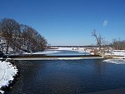
Lower Fox
All of the locks along the Lower Fox have been placed on the National and State Register of Historic Places. Since 1983 efforts were made to reopen the Lower Fox lock system to pleasure craft. In 2001, the State of Wisconsin created the Fox River Navigational System Authority to direct the effort. Private organizations began to raise money for construction. In 2006, the first locks in Appleton were reopened. By 2010, the entire Lower Fox (with the exception of Rapide Croche), is expected to reopen. Congress will provide matching funds.
Features
The following list of features are provided for the current waterway, from Lake Michigan to the Mississippi River east to west:| Location | Feature | Elevation (lower pool) |
Elevation (upper pool) |
River distance from Green Bay |
River distance from Prairie du Chien |
Comment |
|---|---|---|---|---|---|---|
| Green Bay Green Bay, Wisconsin Green Bay is a city in and the county seat of Brown County in the U.S. state of Wisconsin, located at the head of Green Bay, a sub-basin of Lake Michigan, at the mouth of the Fox River. It has an elevation of above sea level and is located north of Milwaukee. As of the 2010 United States Census,... |
Green Bay | 578 ft (176.2 m) | 578 ft (176.2 m) | 0 mi (0 km) | 280 mi (450.6 km) | |
| De Pere De Pere, Wisconsin De Pere is a city located in Brown County, Wisconsin, United States. The population was 20,559 at the 2000 census. De Pere is a suburb of Green Bay and is part of the Green Bay Metropolitan Statistical Area.-Registered historic places:... |
Lock | 578 ft (176.2 m) | 588 ft (179.2 m) | 7 mi (11.3 km) | 273 mi (439.3 km) | Operating |
| Wrightstown | Little Kaukauna Lock & Dam | 588 ft (179.2 m) | 592 ft (180.4 m) | 13 mi (20.9 km) | 267 mi (429.7 km) | Operating |
| Wrightstown | Rapide Croche Lock & dam | 592 ft (180.4 m) | 603 ft (183.8 m) | 20 mi (32.2 km) | 260 mi (418.4 km) | Permanently closed |
| Kaukauna | Lock 5 | 603 ft (183.8 m) | 612 ft (186.5 m) | 24 mi (38.6 km) | 256 mi (412 km) | Being upgraded |
| Kaukauna | Lock 4 | 612 ft (186.5 m) | 622 ft (189.6 m) | 24 mi (38.6 km) | 256 mi (412 km) | Being upgraded |
| Kaukauna | Lock 3 | 622 ft (189.6 m) | 632 ft (192.6 m) | 24 mi (38.6 km) | 256 mi (412 km) | Being upgraded |
| Kaukauna | Lock 2 | 632 ft (192.6 m) | 642 ft (195.7 m) | 24 mi (38.6 km) | 256 mi (412 km) | Being upgraded |
| Kaukauna | Lock 1 | 642 ft (195.7 m) | 652 ft (198.7 m) | 24 mi (38.6 km) | 256 mi (412 km) | Has guard lock, being upgraded |
| Combined Locks | Lower Lock | 652 ft (198.7 m) | 662 ft (201.8 m) | 26 mi (41.8 km) | 254 mi (408.8 km) | Being upgraded |
| Combined Locks | Upper Lock | 662 ft (201.8 m) | 672 ft (204.8 m) | 26 mi (41.8 km) | 254 mi (408.8 km) | Being upgraded |
| Little Chute Little Chute, Wisconsin Little Chute is a village in Outagamie County, Wisconsin, United States. The population was 10,476 at the 2000 census.-Geography:Little Chute is located at .... |
Lock & Dam | 672 ft (204.8 m) | 685 ft (208.8 m) | 27 mi (43.5 km) | 253 mi (407.2 km) | Has guard lock, being upgraded |
| Kimberly Kimberly, Wisconsin Kimberly is a village in Outagamie County, Wisconsin, United States. The population was 6,146 at the 2000 census.-History:Kimberly was founded in 1889 and was named after John A... |
Cedar Lock & Dam | 685 ft (208.8 m) | 695 ft (211.8 m) | 28 mi (45.1 km) | 252 mi (405.6 km) | Being upgraded |
| Appleton Appleton -People:* Alistair Appleton, British television presenter* Charles W. Appleton, of GE* Colin Appleton, footballer* Daniel Appleton, American publisher, 1800s founder of D... |
Lock 4 | 695 ft (211.8 m) | 705 ft (214.9 m) | 31 mi (49.9 km) | 249 mi (400.7 km) | Upgraded |
| Appleton | Lock 3 | 705 ft (214.9 m) | 715 ft (217.9 m) | 32 mi (51.5 km) | 248 mi (399.1 km) | Upgraded |
| Appleton | Lock 2 | 715 ft (217.9 m) | 725 ft (221 m) | 32 mi (51.5 km) | 248 mi (399.1 km) | Upgraded |
| Appleton | Lock 1 | 725 ft (221 m) | 735 ft (224 m) | 32 mi (51.5 km) | 248 mi (399.1 km) | Upgraded |
| Appleton | Little Lake Butte des Morts | 735 ft (224 m) | 735 ft (224 m) | 37 mi (59.5 km) | 243 mi (391.1 km) | Lake |
| Menasha | Lock | 735 ft (224 m) | 746 ft (227.4 m) | 37 mi (59.5 km) | 243 mi (391.1 km) | Being upgraded |
| Neenah | Lake Winnebago | 746 ft (227.4 m) | 746 ft (227.4 m) | 39 mi (62.8 km) | 241 mi (387.9 km) | Lake |
| Oshkosh Oshkosh Oshkosh may refer to:Places in the United States* Oshkosh, Wisconsin, a city and the largest place with the name* Oshkosh , Wisconsin* Oshkosh Township, Yellow Medicine County, Minnesota* Oshkosh, Nebraska... |
Big Lake Butte des Morts | 746 ft (227.4 m) | 746 ft (227.4 m) | 65 mi (104.6 km) | 215 mi (346 km) | Lake |
| Butte Des Morts | Wolf River | 746 ft (227.4 m) | 746 ft (227.4 m) | 66 mi (106.2 km) | 214 mi (344.4 km) | Major tributary |
| Eureka | Fishway and Lock | 746 ft (227.4 m) | 750 ft (228.6 m) | 80 mi (128.7 km) | 200 mi (321.9 km) | Operating |
| Berlin | Abandoned Dam & Lock | 750 ft (228.6 m) | 754 ft (229.8 m) | 90 mi (144.8 km) | 190 mi (305.8 km) | Slated for removal |
| White River | Open River | 754 ft (229.8 m) | 754 ft (229.8 m) | 96 mi (154.5 km) | 184 mi (296.1 km) | Removed |
| Princeton | Dam and Abandoned Lock | 754 ft (229.8 m) | 757 ft (230.7 m) | 98 mi (157.7 km) | 182 mi (292.9 km) | Crest boards |
| Marquette Marquette, Wisconsin Marquette is a village in Green Lake County, Wisconsin, United States. The population was 169 at the 2000 census. The village is located within the Town of Marquette... |
Lake Puckaway | 763 ft (232.6 m) | 763 ft (232.6 m) | 122 mi (196.3 km) | 158 mi (254.3 km) | Lake |
| Grand River | Abandoned Dam & Lock | 763 ft (232.6 m) | 764 ft (232.9 m) | 131 mi (210.8 km) | 149 mi (239.8 km) | Slated for removal |
| Montello Montello -Companies:* Montello Private Finance, a real estate bridging finance company based in London.-Places:Australia*Montello, Tasmania, the home ground of Burnie United FCItaly*Montello, Lombardy, a comune in the Province of Bergamo... |
Dam and Abandoned Lock | 764 ft (232.9 m) | 764 ft (232.9 m) | 131 mi (210.8 km) | 149 mi (239.8 km) | |
| Endeavor | Buffalo Lake | 769 ft (234.4 m) | 769 ft (234.4 m) | 142 mi (228.5 km) | 138 mi (222.1 km) | Lake |
| Governor's Bend Park | Abandoned Dam & Lock | 769 ft (234.4 m) | 774 ft (235.9 m) | 147 mi (236.6 km) | 133 mi (214 km) | Slated for removal |
| Portage Portage, Wisconsin Portage is a city in and the county seat of Columbia County, Wisconsin, United States. The population was 10,662 at the 2010 census making it the largest city in Columbia County... |
Canal | 780 ft (237.7 m) | 780 ft (237.7 m) | 162 mi (260.7 km) | 118 mi (189.9 km) | Closed |
| Portage | Lock at Wis River | 780 ft (237.7 m) | 782 ft (238.4 m) | 165 mi (265.5 km) | 115 mi (185.1 km) | Closed |
| Prairie du Sac | Lake Wisconsin | 774 ft (235.9 m) | 774 ft (235.9 m) | 176 mi (283.2 km) | 104 mi (167.4 km) | |
| Merrimac | Ferry | 774 ft (235.9 m) | 774 ft (235.9 m) | 180 mi (289.7 km) | 101 mi (162.5 km) | |
| Prairie du Sac | Dam | 735 ft (224 m) | 774 ft (235.9 m) | 188 mi (302.6 km) | 92 mi (148.1 km) | Locks unusable |
| Prairie du Chien | Mississippi River | 611 ft (186.2 m) | 611 ft (186.2 m) | 280 mi (450.6 km) | 0 mi (0 km) | Mississippi River Mile 631 |
External links
- Map and Section of Wisconsin and Fox River, 1867 at the Great Lakes Maps exhibit of the Wisconsin's Water Library