

Brazilian Highway System
Encyclopedia
The Brazilian Highway System (Portuguese: Sistema Nacional de Viação) is the highway
system of Brazil
, the fourth largest in the World. As of 2010, the system consists of almost 2 million kilometers of roads, of which approximately 200,000 km are paved.
As it is in the United States
, Canada
or most countries in Europe
, larger/wider highways have higher speed limits than normal urban roads (typically between 80 km/h and 120 km/h), although minor highways, unpaved highways and sections of major highways running inside urban areas have a lower speed limit in general. The national blank speed limit for cars driving in non-urban roads is 110 km/h unless otherwise stated, regardless of the road design, weather or daylight.
Annually, it is estimated that more than 1.2 billion people travel in the Brazilian highways (against the 120 million travelling in airlines).
 Brazilian Regional highways are named YY-XXX, where YY is the abbreviation of the state where the highway is running in and XXX is a number (e.g. SP-280; where SP means that the highway is under São Paulo state administration).
Brazilian National highways are named BR-XXX. National highways connect multiple states altogether, are of major importance to the national economy
and/or connect Brazil to another country. The meaning of the numbers are:
Often Brazilian highways receive names (famous people, etc.), but continue to have a YY/BR-XXX name (example: Rodovia Castelo Branco is also SP-280.)
See highway system of São Paulo
for numbering designation for São Paulo state roads, also used in some other states.
, then governor of São Paulo, finished Via Anchieta, linking Santos
to São Paulo
, and Via Anhanguera, linking São Paulo to Campinas
, two highways using the most modern standards of that time. It would be the major accomplishment on the area for years.
When Juscelino Kubitschek
assumed the presidency, he created subsidies to bring multinationals like Volkswagen
to Brazil and created thousand of miles of roads, linking distant regions of the country. Most of these roads follow poor standards, but they created links where there were none. The military presidents would mostly follow these same standards to expand the system. The exceptions would be the modern highways built by the São Paulo State Government.
In 1967, the first stretch of Via Castelo Branco (SP-280), a 2X3 and 2X2 limited-access highway built at par with standards drawn by FHWA, linking the city of São Paulo to the western region of the São Paulo State, was finished, creating a standard for other highways in the same state. In the same year, the Via Dutra was modernized, allowing a fast and modern trip between São Paulo and Rio de Janeiro
.
The country would reach 200,000 km paved in 2000. Between 1995 and 2005 three major highways (BR-101
, linking Curitiba
to Porto Alegre
; Via Regis Bittencourt, linking São Paulo to Curitiba; and Via Fernão Dias, linking São Paulo to Belo Horizonte
) were modernized. Until then, most of these highways were known for their high mortality rate
due to traffic accidents.
The Southern
and Southeast
regions of Brazil are heavily connected by highways, most of them paved; the North
region is the least connected with paved highways due to the presence of the Amazon rainforest
. In this region, highways, when they are present, generally are unpaved. Manaus
, for example, has no major paved highways connecting it to any other city but Boa Vista
in the north.
Highways are the main means of transportation in Brazil, both in number of movement of passengers and movement of freight and goods.
The major problem of highways as the national arterial system is that it is expensive to transport freight: train
s are much cheaper, generate less pollution
and create no traffic problems as truck
s do. , Brazil had only 24,000 km of railways, used mainly for mineral resources transportation (mine
s to seaport), while trucks were responsible for almost every other means of freight transportation.
Another significant problem that Brazilian federal highways face is deterioration because of weather
conditions and heavy usage. The government's investment in highway maintenance often falls short of the necessary amounts, resulting in the lack of maintenance of thousands of kilometers of federal highways, especially the minor ones. Pothole
s and wavy asphalt
are common on several highways. Because of this difficulty, the government decided to grant parts of highways to private companies who will maintain the highway in exchange for the right to charge tolls. The problem with this partial solution is explained in the section below.
to Rio de Janeiro
, which was finished on the 1975 with a 2X2 setting, but retained some grade crossings. Later, other roads were built or expanded to dual carriageways, like the Via Fernão Dias, connecting Belo Horizonte
to São Paulo; the Via Bandeirantes, connecting São Paulo to the State's countryside; the Via Litoral Sul, connecting Curitiba
to Florianópolis
, and a few others.
Nowadays, the Government and the private section are planning to duplicate thousands of kilometers, with few hundreds already on their way. For example, the first section of the Northeastern Corridor, connecting the capital city of Natal
to Palmares
, southern of Pernambuco
State, the road connecting Goiânia
to Uberlândia
, this one on the west of Minas Gerais
state, the road connecting Palhoça
, on Florianópolis Metropolitan Area, to Osório
, a city 90 km west from Porto Alegre
, already connected by a dual, modern, six lane carriageway road, and few others.
The projects are the link between Brasília
and Belo Horizonte (800 km), Belo Horizonte and Juiz de Fora
(close to the Minas Gerais-Rio de Janeiro State Border), with 200 km, the Rio-Bahia Road System, between Três Rios
(app. 150 km from Rio de Janeiro City, already connected to the State Capital by a dual carriageway road) and Feira de Santana
(app. 200 km from Salvador
, also connected by a dual carriageway road), and the important connection between Palmares and Salvador.
It is important to say that the majority of these roads are or are going to be tolled roads maintained by the private concessionaires (like the link between Florianópolis and Belo Horizonte, or the link between Rio de Janeiro and Salvador, or even the link between Rio de Janeiro and São Paulo), however, some roads, like the link between Salvador and Natal, which will be more than a 1,000 km long of a full dual carriageway system, will not, by the next few years, be tolled, and will link, more likely by 2014, 70% of all the economy and the population of the Northeast Region.
ling) of CONTRAN (Conselho Nacional de Trânsito - National Transit (Road Transportation) Council), the national government organization responsible for the rules and laws of the Brazilian road system (including all the ones inside urban areas), and DENATRAN (Departamento Nacional de Trânsito - National Road Transport Department), the national government organization responsible for enforcing these laws, but funding it is a government (from the state where the highways is/passes by) or private responsibility. All major Brazilian paved highways have toll stations.
In the 1990s, many state governments decided to privatize public-controlled paved highways, in order to generate extra income to the state's budget
(for social care mainly). These governments argued that private funding would make problematic highways much better, because of the investments received. In fact, many private-controlled paved highways are in very good condition (with many of them having critical problems before), but other people argue that private-controlled paved highways charge more at the toll stations and that these highways have more toll stations than public-controlled paved highways (in order to compensate for the investment
done).

, official name Rodovia Bernardo Sayão
(the name of its chief engineer, who died in an accident during the construction of the highway, when a tree fell on him), is one of the longest highways in South America and runs in an almost perfect North-South direction, from the city of Belém
and the Federal capital city of Brasília
.
BR-040 is the modern way of the called "New Way", opened in the 18th century that linked Ouro Preto
, the main center of gold mines of Minas Gerais
to the Rio de Janeiro
harbour.
In 1861 the road was paved from Petrópolis
to Juiz de Fora
, being the first road paved in Latin America
until the 1920s. In 1928, Petrópolis was connected to Rio de Janeiro
with a paved road.
In the 1930s the route of the road was changed to pass by the new capital of Minas Gerais, Belo Horizonte
, although it was unpaved until 1957, when the road was extended to Brasília
, the new capital of Brazil.
From 1951 to 1973 BR-040 was called BR-3 and was famous for its dangerous bends, such as the Almas Bridge, near Belo Horizonte, which is used until today. In the 1970s the part from Rio de Janeiro to Juiz de Fora was modernized and become a two-laned road.
Cities where the BR-040 runs or passes by: Lusilândia, Belo Horizonte
, Juiz de Fora
, Rio de Janeiro
.
Cities where the BR-050 runs or passes by: Brasília
, Uberlândia
and Uberaba
. At the border of the state of São Paulo, it merges with Rodovia Anhanguera
(SP-330) and passes by Ribeirao Preto
, Limeira
, Campinas
and São Paulo
, then it merges with Rodovia Anchieta
(SP-150) and passes by São Bernardo do Campo
and Santos
.
runs in a north-south way, along Brazil's eastern coast. It is Brazil's second major highway, and the longest in the country (nearly 4800 km long). It connects more states capitals than any other "rodovia" in the country, in the total, 12 capitals are directly connected by BR-101.
The Rio-Niterói Bridge
is part of the BR-101.
Cities where the BR-101 runs or passes by: Natal, João Pessoa
, Olinda
, Recife
, Maceió
, Aracaju
, Feira de Santana
, Itabuna
, Ilhéus
, Porto Seguro
, Linhares
, Vitória, Guarapari
, Niterói
, Rio de Janeiro
, Barra Mansa
, Santos
, Curitiba
, Joinville
, Florianópolis
, Criciúma
, Osório
.
The highway is especially busy along the Joinville-Curitiba-São Paulo-Rio de Janeiro section. The Curitiba-São Paulo section of the highway is known as Rodovia Régis Bittencourt
, nicknamed "Rodovia da Morte" (Highway of death), due to its many accidents caused by the unstable weather conditions of the region. The São Paulo-Rio de Janeiro section is named Rodovia Presidente Dutra, and it is the busiest section of the highway, running into or near of 15 cities with more than 200.000 inhabitants.
Cities where the BR-116 runs or passes by: Fortaleza
, Salgueiro
, Feira de Santana
, Vitória da Conquista
, Teófilo Otoni
, Governador Valadares
, Rio de Janeiro
, Volta Redonda
, São José dos Campos
, São Paulo
, Curitiba
, Lages
, Canoas
, Porto Alegre
to another Brazilian state capital. It starts in Manaus
, passes into Jundia
, Novo Paraiso, Caracarai
, Mucajai
, Boa Vista, Roraima
and Paracaima, in the extreme north of the country, connecting Brazil with the neighbouring country of Venezuela
.
And also to several villages in Venezuela
, also crosses the area Waimiri-Atroari
, located in the border between Amazonas and Roraima. The highway is closed this stretch at night and are advised not to stop inside the reserve.
It was planned to be more or less 8.000 km long, mostly paved and connecting the North and Northeast
Brazilian regions and Ecuador
and Peru
, but nowadays it is 2.500 km long and mostly unpaved (dirt). BR-230 was inaugurated on August 30, 1972, and since then did not suffer any major alterations.
Other problems were the beginning of deforestation
and the creation of numerous small villages along the highway, and traffic is impracticable during the rainy season of the year (October - March). Still, the highway is very important, by connecting the region with the rest of the country. A major plan to pave most of the highway is under consideration by the Brazilian government, as of 2004.
Cities where the highway run or passes by: Aguiarnópolis
, Maraba
, Altamira
, Itaituba
, Humaita
, Lábrea
.
that runs east-west, starting in Recife
- Pernambuco
and goes up to west ending in Parnamirim. It is of major importance to Pernambuco
, since connects almost all interior with the capital recife
to east and with the amazonas region to west. It has double lanes between Recife and Caruaru
( 160 km W).
Major cities connected by the BR-232:Recife, Jaboatao dos Guararapes
, Gravata
, Caruaru
, Belo Jardim
, Arcoverde
, Serra Talhada
, Salgueiro
and Parnamirim
. BR-232 is approximately 554 km long and inter-connects with 9 Federal Highways of vital importance to the Northeast
of Brazil
: BR-101, BR-408, BR-104, BR-423, BR-424, BR-110, BR-426, BR-116 and BR-316.
that runs east
-west
, starting from the Friendship Bridge
(which connects Brazil with Paraguay) and goes up to Paranaguá
. It is of major importance to Paraguay
, since major importations are made using the Paranaguá seaport.
Major cities connected by the BR-277: Foz do Iguaçu
, Medianeira
, Cascavel
, Guarapuava
, Ponta Grossa
, Curitiba
, Paranaguá. BR-277 is approximately 650 km long.
, it is mostly unpaved, and as a result, traffic is impracticable in the rainy seasons of the year. Despite this, BR-319 is a major highway of national significance because it connects Manaus to the southern regions of the country (which have greater population density).
As of December 2005, this highway is under reconstruction within a 420 kilometer stretch between Caiero and Humaita
. The complete re-paving work is expected to be finished by 2007, reestablishing the land connection between Manaus
and the rest of the country.
Major cities connected by the BR-319: Manaus
(by ferry from Careiro da Várzea
), Caiero, Humaita
, Porto Velho
.
, as it is called, is a highway which runs in the Brazilian states of São Paulo and southern and eastern regions of Minas Gerais
.
Major cities connected by the BR-381: São Paulo
, Mairiporã
, Atibaia
, Pouso Alegre
, Varginha
, Oliveira
and Belo Horizonte
.
Highway
A highway is any public road. In American English, the term is common and almost always designates major roads. In British English, the term designates any road open to the public. Any interconnected set of highways can be variously referred to as a "highway system", a "highway network", or a...
system of Brazil
Brazil
Brazil , officially the Federative Republic of Brazil , is the largest country in South America. It is the world's fifth largest country, both by geographical area and by population with over 192 million people...
, the fourth largest in the World. As of 2010, the system consists of almost 2 million kilometers of roads, of which approximately 200,000 km are paved.
As it is in the United States
United States
The United States of America is a federal constitutional republic comprising fifty states and a federal district...
, Canada
Canada
Canada is a North American country consisting of ten provinces and three territories. Located in the northern part of the continent, it extends from the Atlantic Ocean in the east to the Pacific Ocean in the west, and northward into the Arctic Ocean...
or most countries in Europe
Europe
Europe is, by convention, one of the world's seven continents. Comprising the westernmost peninsula of Eurasia, Europe is generally 'divided' from Asia to its east by the watershed divides of the Ural and Caucasus Mountains, the Ural River, the Caspian and Black Seas, and the waterways connecting...
, larger/wider highways have higher speed limits than normal urban roads (typically between 80 km/h and 120 km/h), although minor highways, unpaved highways and sections of major highways running inside urban areas have a lower speed limit in general. The national blank speed limit for cars driving in non-urban roads is 110 km/h unless otherwise stated, regardless of the road design, weather or daylight.
Annually, it is estimated that more than 1.2 billion people travel in the Brazilian highways (against the 120 million travelling in airlines).
Nomenclature
Brazilian National highways are named BR-XXX. National highways connect multiple states altogether, are of major importance to the national economy
Economic system
An economic system is the combination of the various agencies, entities that provide the economic structure that defines the social community. These agencies are joined by lines of trade and exchange along which goods, money etc. are continuously flowing. An example of such a system for a closed...
and/or connect Brazil to another country. The meaning of the numbers are:
- 000-099 - it means that the highway runs radially from BrasíliaBrasíliaBrasília is the capital city of Brazil. The name is commonly spelled Brasilia in English. The city and its District are located in the Central-West region of the country, along a plateau known as Planalto Central. It has a population of about 2,557,000 as of the 2008 IBGE estimate, making it the...
. It is an exception to the cases below. - 100-199 - it means that the highway runs in a south-north way
- 200-299 - it means that the highway runs in a west-east way
- 300-399 - it means that the highway runs in a diagonal way. Highways with odd numbers run northeast-southwest, while even numbers run northwest-southeast.
- 400-499 - it means that the highway interconnects two major highways.
Often Brazilian highways receive names (famous people, etc.), but continue to have a YY/BR-XXX name (example: Rodovia Castelo Branco is also SP-280.)
See highway system of São Paulo
Highway system of São Paulo
The highway system of São Paulo is the largest statewide road transportation system in Brazil, with 34,650 km. It consists of a hugely interconnected network of municipal , state and federal roads...
for numbering designation for São Paulo state roads, also used in some other states.
Growth, net density, importance and problems
In 1953, Adhemar de BarrosAdhemar de Barros
Adhemar Pereira de Barros was the mayor of São Paulo , and twice elected Governor of São Paulo . He was also the federal interventor in the state of São Paulo nominated by Brazilian dictator Getúlio Vargas, serving between 1938 and 1941...
, then governor of São Paulo, finished Via Anchieta, linking Santos
Santos (São Paulo)
-Sister cities: Shimonoseki, Japan Nagasaki, Japan Funchal, Portugal Trieste, Italy Coimbra, Portugal Ansião, Portugal Arouca, Portugal Ushuaia, Argentina Havana, Cuba Taizhou. China Ningbo. China Constanţa, Romania Ulsan, South Korea Colón, Panama* Cadiz, Spain...
to São Paulo
São Paulo
São Paulo is the largest city in Brazil, the largest city in the southern hemisphere and South America, and the world's seventh largest city by population. The metropolis is anchor to the São Paulo metropolitan area, ranked as the second-most populous metropolitan area in the Americas and among...
, and Via Anhanguera, linking São Paulo to Campinas
Campinas
Campinas is a city and municipality located in the coastal interior of the state of São Paulo, Brazil. is the administrative center of the meso-region of the same name, with 3,783,597 inhabitants as of the 2010 Census, consisting of 49 cities....
, two highways using the most modern standards of that time. It would be the major accomplishment on the area for years.
When Juscelino Kubitschek
Juscelino Kubitschek de Oliveira
Juscelino Kubitschek de Oliveira , known also by his initials JK, was a prominent Brazilian politician of gypsy Czech origin who was President of Brazil from 1956 to 1961. He was born in Diamantina, Minas Gerais, and died in 1976...
assumed the presidency, he created subsidies to bring multinationals like Volkswagen
Volkswagen
Volkswagen is a German automobile manufacturer and is the original and biggest-selling marque of the Volkswagen Group, which now also owns the Audi, Bentley, Bugatti, Lamborghini, SEAT, and Škoda marques and the truck manufacturer Scania.Volkswagen means "people's car" in German, where it is...
to Brazil and created thousand of miles of roads, linking distant regions of the country. Most of these roads follow poor standards, but they created links where there were none. The military presidents would mostly follow these same standards to expand the system. The exceptions would be the modern highways built by the São Paulo State Government.
In 1967, the first stretch of Via Castelo Branco (SP-280), a 2X3 and 2X2 limited-access highway built at par with standards drawn by FHWA, linking the city of São Paulo to the western region of the São Paulo State, was finished, creating a standard for other highways in the same state. In the same year, the Via Dutra was modernized, allowing a fast and modern trip between São Paulo and Rio de Janeiro
Rio de Janeiro
Rio de Janeiro , commonly referred to simply as Rio, is the capital city of the State of Rio de Janeiro, the second largest city of Brazil, and the third largest metropolitan area and agglomeration in South America, boasting approximately 6.3 million people within the city proper, making it the 6th...
.
The country would reach 200,000 km paved in 2000. Between 1995 and 2005 three major highways (BR-101
BR-101
The BR-101 is a longitudinal highway of Brazil. It is the longest in the country with a length of nearly , and it is also considered the most important....
, linking Curitiba
Curitiba
Curitiba is the capital of the Brazilian state of Paraná. It is the largest city with the biggest economy of both Paraná and southern Brazil. The population of Curitiba numbers approximately 1.75 million people and the latest GDP figures for the city surpass US$61 billion according to...
to Porto Alegre
Porto Alegre
Porto Alegre is the tenth most populous municipality in Brazil, with 1,409,939 inhabitants, and the centre of Brazil's fourth largest metropolitan area . It is also the capital city of the southernmost Brazilian state of Rio Grande do Sul. The city is the southernmost capital city of a Brazilian...
; Via Regis Bittencourt, linking São Paulo to Curitiba; and Via Fernão Dias, linking São Paulo to Belo Horizonte
Belo Horizonte
Belo Horizonte is the capital of and largest city in the state of Minas Gerais, located in the southeastern region of Brazil. It is the third largest metropolitan area in the country...
) were modernized. Until then, most of these highways were known for their high mortality rate
Mortality rate
Mortality rate is a measure of the number of deaths in a population, scaled to the size of that population, per unit time...
due to traffic accidents.
The Southern
Southern Region, Brazil
The South Region of Brazil is one of the five regions of Brazil. It includes the states of Paraná, Santa Catarina and Rio Grande do Sul and covers 576,409.6 km ², being the smallest portion of the country...
and Southeast
Southeast Region, Brazil
The Southeast Region of Brazil is composed by the states of Espírito Santo, Minas Gerais, Rio de Janeiro and São Paulo. It is the richest region of the country, responsible for approximately 60% of the Brazilian GDP. São Paulo, Rio de Janeiro and Minas Gerais are three richest states of Brazil,...
regions of Brazil are heavily connected by highways, most of them paved; the North
North Region, Brazil
The North Region of Brazil is the largest Region of Brazil, corresponding to 45.27% of the national territory. It is the least inhabited of the country, and contributes with a minor percentage in the national GDP and population...
region is the least connected with paved highways due to the presence of the Amazon rainforest
Rainforest
Rainforests are forests characterized by high rainfall, with definitions based on a minimum normal annual rainfall of 1750-2000 mm...
. In this region, highways, when they are present, generally are unpaved. Manaus
Manaus
Manaus is a city in Brazil, the capital of the state of Amazonas. It is situated at the confluence of the Negro and Solimões rivers. It is the most populous city of Amazonas, according to the statistics of Brazilian Institute of Geography and Statistics, and is a popular ecotourist destination....
, for example, has no major paved highways connecting it to any other city but Boa Vista
Boa Vista, Roraima
Boa Vista is the capital of the Brazilian state of Roraima. Situated on the western bank of the River Branco, the city lies 220 km away from Brazil's border with Venezuela. It is the only Brazilian capital located entirely above the Equator...
in the north.
Highways are the main means of transportation in Brazil, both in number of movement of passengers and movement of freight and goods.
The major problem of highways as the national arterial system is that it is expensive to transport freight: train
Train
A train is a connected series of vehicles for rail transport that move along a track to transport cargo or passengers from one place to another place. The track usually consists of two rails, but might also be a monorail or maglev guideway.Propulsion for the train is provided by a separate...
s are much cheaper, generate less pollution
Pollution
Pollution is the introduction of contaminants into a natural environment that causes instability, disorder, harm or discomfort to the ecosystem i.e. physical systems or living organisms. Pollution can take the form of chemical substances or energy, such as noise, heat or light...
and create no traffic problems as truck
Truck
A truck or lorry is a motor vehicle designed to transport cargo. Trucks vary greatly in size, power, and configuration, with the smallest being mechanically similar to an automobile...
s do. , Brazil had only 24,000 km of railways, used mainly for mineral resources transportation (mine
Mining
Mining is the extraction of valuable minerals or other geological materials from the earth, from an ore body, vein or seam. The term also includes the removal of soil. Materials recovered by mining include base metals, precious metals, iron, uranium, coal, diamonds, limestone, oil shale, rock...
s to seaport), while trucks were responsible for almost every other means of freight transportation.
Another significant problem that Brazilian federal highways face is deterioration because of weather
Weather
Weather is the state of the atmosphere, to the degree that it is hot or cold, wet or dry, calm or stormy, clear or cloudy. Most weather phenomena occur in the troposphere, just below the stratosphere. Weather refers, generally, to day-to-day temperature and precipitation activity, whereas climate...
conditions and heavy usage. The government's investment in highway maintenance often falls short of the necessary amounts, resulting in the lack of maintenance of thousands of kilometers of federal highways, especially the minor ones. Pothole
Pothole
A pothole is a type of disruption in the surface of a roadway where a portion of the road material has broken away, leaving a hole.- Formation :...
s and wavy asphalt
Asphalt
Asphalt or , also known as bitumen, is a sticky, black and highly viscous liquid or semi-solid that is present in most crude petroleums and in some natural deposits, it is a substance classed as a pitch...
are common on several highways. Because of this difficulty, the government decided to grant parts of highways to private companies who will maintain the highway in exchange for the right to charge tolls. The problem with this partial solution is explained in the section below.
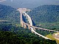
Road Duplication
Due to the country's growth and the associated traffic increase, the Government has started the duplication of main roads sections. The first one to be completed was the so called Via Dutra (BR-116), the important road connecting São PauloSão Paulo
São Paulo is the largest city in Brazil, the largest city in the southern hemisphere and South America, and the world's seventh largest city by population. The metropolis is anchor to the São Paulo metropolitan area, ranked as the second-most populous metropolitan area in the Americas and among...
to Rio de Janeiro
Rio de Janeiro
Rio de Janeiro , commonly referred to simply as Rio, is the capital city of the State of Rio de Janeiro, the second largest city of Brazil, and the third largest metropolitan area and agglomeration in South America, boasting approximately 6.3 million people within the city proper, making it the 6th...
, which was finished on the 1975 with a 2X2 setting, but retained some grade crossings. Later, other roads were built or expanded to dual carriageways, like the Via Fernão Dias, connecting Belo Horizonte
Belo Horizonte
Belo Horizonte is the capital of and largest city in the state of Minas Gerais, located in the southeastern region of Brazil. It is the third largest metropolitan area in the country...
to São Paulo; the Via Bandeirantes, connecting São Paulo to the State's countryside; the Via Litoral Sul, connecting Curitiba
Curitiba
Curitiba is the capital of the Brazilian state of Paraná. It is the largest city with the biggest economy of both Paraná and southern Brazil. The population of Curitiba numbers approximately 1.75 million people and the latest GDP figures for the city surpass US$61 billion according to...
to Florianópolis
Florianópolis
-Climate:Florianópolis experiences a warm humid subtropical climate, falling just short of a true tropical climate. The seasons of the year are distinct, with a well-defined summer and winter, and characteristic weather for autumn and spring. Frost is infrequent, but occurs occasionally in the winter...
, and a few others.
Nowadays, the Government and the private section are planning to duplicate thousands of kilometers, with few hundreds already on their way. For example, the first section of the Northeastern Corridor, connecting the capital city of Natal
Natal, Rio Grande do Norte
-History:The northeastern tip of South America, Cabo São Roque, to the north of Natal and the closest point to Europe from Latin America, was first visited by European navigators in 1501, in the 1501–1502 Portuguese expedition led by Amerigo Vespucci, who named the spot after the saint of the day...
to Palmares
Palmares
Palmares may refer to:*Palmares, Pernambuco, a municipality in the state of Pernambuco in Brazil*Palmares Paulista*Palmares Canton, a canton in the province of Alajuela in Costa Rica...
, southern of Pernambuco
Pernambuco
Pernambuco is a state of Brazil, located in the Northeast region of the country. To the north are the states of Paraíba and Ceará, to the west is Piauí, to the south are Alagoas and Bahia, and to the east is the Atlantic Ocean. There are about of beaches, some of the most beautiful in the...
State, the road connecting Goiânia
Goiânia
-Climate:The city has a tropical wet and dry climate with an average temperature of . There's a wet season, from October to April, and a dry one, from May to September. Annual rainfall is around 1,520 mm....
to Uberlândia
Uberlândia
Uberlândia is the main town in the Triangle region, west of the state of Minas Gerais, Brazil. With a population of 604,013 inhabitants, according to 2010 estimates, the city is the second largest in the state second only to Belo Horizonte...
, this one on the west of Minas Gerais
Minas Gerais
Minas Gerais is one of the 26 states of Brazil, of which it is the second most populous, the third richest, and the fourth largest in area. Minas Gerais is the Brazilian state with the largest number of Presidents of Brazil, the current one, Dilma Rousseff, being one of them. The capital is the...
state, the road connecting Palhoça
Palhoça
-History:Palhoça was founded in 1793, when the city was part of the way between Lages and Florianópolis in order to protect the capital state from possible invasions. It name comes from “straw roof” because the huge quantity of houses with this kind of roof, once the first Palhoça citizens was the...
, on Florianópolis Metropolitan Area, to Osório
Osório
Osório is a city in Rio Grande Do Sul, Brazil. Its population is about 40,000 inhabitants.Osório is situated 90 km east of Porto Alegre....
, a city 90 km west from Porto Alegre
Porto Alegre
Porto Alegre is the tenth most populous municipality in Brazil, with 1,409,939 inhabitants, and the centre of Brazil's fourth largest metropolitan area . It is also the capital city of the southernmost Brazilian state of Rio Grande do Sul. The city is the southernmost capital city of a Brazilian...
, already connected by a dual, modern, six lane carriageway road, and few others.
The projects are the link between Brasília
Brasília
Brasília is the capital city of Brazil. The name is commonly spelled Brasilia in English. The city and its District are located in the Central-West region of the country, along a plateau known as Planalto Central. It has a population of about 2,557,000 as of the 2008 IBGE estimate, making it the...
and Belo Horizonte (800 km), Belo Horizonte and Juiz de Fora
Juiz de Fora
-Industry, Trade, and Culture:Juiz de Fora is the second most important industrial center in the state of Minas Gerais, despite being the fourth largest in terms of population. It was once the state's largest city, position which was held up until the beginning of the 20th century...
(close to the Minas Gerais-Rio de Janeiro State Border), with 200 km, the Rio-Bahia Road System, between Três Rios
Três Rios
Três Rios is a municipality located in the Brazilian state of Rio de Janeiro. As of 2007 its population was 72,848 and its area is 325 km².As of 2009, the mayor of Três Rios is Vinicius Farah.-Sports:...
(app. 150 km from Rio de Janeiro City, already connected to the State Capital by a dual carriageway road) and Feira de Santana
Feira de Santana
Feira de Santana is a city in Bahia, Brazil. It is the second-most populous city in the state, with a population of 700,000 according to IBGE's estimate. It is located 115 km northwest of Salvador, Bahia's capital city. These cities are connected by BR-324, a four-lane divided highway...
(app. 200 km from Salvador
Salvador, Bahia
Salvador is the largest city on the northeast coast of Brazil and the capital of the Northeastern Brazilian state of Bahia. Salvador is also known as Brazil's capital of happiness due to its easygoing population and countless popular outdoor parties, including its street carnival. The first...
, also connected by a dual carriageway road), and the important connection between Palmares and Salvador.
It is important to say that the majority of these roads are or are going to be tolled roads maintained by the private concessionaires (like the link between Florianópolis and Belo Horizonte, or the link between Rio de Janeiro and Salvador, or even the link between Rio de Janeiro and São Paulo), however, some roads, like the link between Salvador and Natal, which will be more than a 1,000 km long of a full dual carriageway system, will not, by the next few years, be tolled, and will link, more likely by 2014, 70% of all the economy and the population of the Northeast Region.
Public vs. private administration
Brazilian highways are under constant observation (laws, rules, highway patrolHighway patrol
A highway patrol is either a police unit created primarily for the purpose of overseeing and enforcing traffic safety compliance on roads and highways, or a detail within an existing local or regional police agency that is primarily concerned with such duties.Duties of highway patrols or traffic...
ling) of CONTRAN (Conselho Nacional de Trânsito - National Transit (Road Transportation) Council), the national government organization responsible for the rules and laws of the Brazilian road system (including all the ones inside urban areas), and DENATRAN (Departamento Nacional de Trânsito - National Road Transport Department), the national government organization responsible for enforcing these laws, but funding it is a government (from the state where the highways is/passes by) or private responsibility. All major Brazilian paved highways have toll stations.
In the 1990s, many state governments decided to privatize public-controlled paved highways, in order to generate extra income to the state's budget
Budget
A budget is a financial plan and a list of all planned expenses and revenues. It is a plan for saving, borrowing and spending. A budget is an important concept in microeconomics, which uses a budget line to illustrate the trade-offs between two or more goods...
(for social care mainly). These governments argued that private funding would make problematic highways much better, because of the investments received. In fact, many private-controlled paved highways are in very good condition (with many of them having critical problems before), but other people argue that private-controlled paved highways charge more at the toll stations and that these highways have more toll stations than public-controlled paved highways (in order to compensate for the investment
Investment
Investment has different meanings in finance and economics. Finance investment is putting money into something with the expectation of gain, that upon thorough analysis, has a high degree of security for the principal amount, as well as security of return, within an expected period of time...
done).
Major Federal Brazilian Highways
BR-010
Also called Rodovia Belém-BrasíliaRodovia Belém-Brasília
Rodovia Belém-Brasília is a federal highway in Brazil. It is named after its chief engineer, who died in an accident during the construction of the highway, when a tree fell over his tent...
, official name Rodovia Bernardo Sayão
Bernardo Sayão
Bernardo Sayão is a municipality located in the Brazilian state of Tocantins. Its population was 4,699 and its area is 927 km²....
(the name of its chief engineer, who died in an accident during the construction of the highway, when a tree fell on him), is one of the longest highways in South America and runs in an almost perfect North-South direction, from the city of Belém
Belém
Belém is a Brazilian city, the capital and largest city of state of Pará, in the country's north region. It is the entrance gate to the Amazon with a busy port, airport and bus/coach station...
and the Federal capital city of Brasília
Brasília
Brasília is the capital city of Brazil. The name is commonly spelled Brasilia in English. The city and its District are located in the Central-West region of the country, along a plateau known as Planalto Central. It has a population of about 2,557,000 as of the 2008 IBGE estimate, making it the...
.
BR-040
BR-040 runs radially from near the national capital Brasília (beginning 100 km south of the beginning of BR-050, in Brasília), in a northwest-southeast way, to Rio de Janeiro city.BR-040 is the modern way of the called "New Way", opened in the 18th century that linked Ouro Preto
Ouro Preto
-History:Founded at the end of the 17th century, Ouro Preto was originally called Vila Rica, or "rich village," the focal point of the gold rush and Brazil's golden age in the 18th century under Portuguese rule....
, the main center of gold mines of Minas Gerais
Minas Gerais
Minas Gerais is one of the 26 states of Brazil, of which it is the second most populous, the third richest, and the fourth largest in area. Minas Gerais is the Brazilian state with the largest number of Presidents of Brazil, the current one, Dilma Rousseff, being one of them. The capital is the...
to the Rio de Janeiro
Rio de Janeiro
Rio de Janeiro , commonly referred to simply as Rio, is the capital city of the State of Rio de Janeiro, the second largest city of Brazil, and the third largest metropolitan area and agglomeration in South America, boasting approximately 6.3 million people within the city proper, making it the 6th...
harbour.
In 1861 the road was paved from Petrópolis
Petrópolis
Petrópolis , also known as The Imperial City of Brazil, is a town in the state of Rio de Janeiro, about 65 km from the city of Rio de Janeiro....
to Juiz de Fora
Juiz de Fora
-Industry, Trade, and Culture:Juiz de Fora is the second most important industrial center in the state of Minas Gerais, despite being the fourth largest in terms of population. It was once the state's largest city, position which was held up until the beginning of the 20th century...
, being the first road paved in Latin America
Latin America
Latin America is a region of the Americas where Romance languages – particularly Spanish and Portuguese, and variably French – are primarily spoken. Latin America has an area of approximately 21,069,500 km² , almost 3.9% of the Earth's surface or 14.1% of its land surface area...
until the 1920s. In 1928, Petrópolis was connected to Rio de Janeiro
Rio de Janeiro
Rio de Janeiro , commonly referred to simply as Rio, is the capital city of the State of Rio de Janeiro, the second largest city of Brazil, and the third largest metropolitan area and agglomeration in South America, boasting approximately 6.3 million people within the city proper, making it the 6th...
with a paved road.
In the 1930s the route of the road was changed to pass by the new capital of Minas Gerais, Belo Horizonte
Belo Horizonte
Belo Horizonte is the capital of and largest city in the state of Minas Gerais, located in the southeastern region of Brazil. It is the third largest metropolitan area in the country...
, although it was unpaved until 1957, when the road was extended to Brasília
Brasília
Brasília is the capital city of Brazil. The name is commonly spelled Brasilia in English. The city and its District are located in the Central-West region of the country, along a plateau known as Planalto Central. It has a population of about 2,557,000 as of the 2008 IBGE estimate, making it the...
, the new capital of Brazil.
From 1951 to 1973 BR-040 was called BR-3 and was famous for its dangerous bends, such as the Almas Bridge, near Belo Horizonte, which is used until today. In the 1970s the part from Rio de Janeiro to Juiz de Fora was modernized and become a two-laned road.
Cities where the BR-040 runs or passes by: Lusilândia, Belo Horizonte
Belo Horizonte
Belo Horizonte is the capital of and largest city in the state of Minas Gerais, located in the southeastern region of Brazil. It is the third largest metropolitan area in the country...
, Juiz de Fora
Juiz de Fora
-Industry, Trade, and Culture:Juiz de Fora is the second most important industrial center in the state of Minas Gerais, despite being the fourth largest in terms of population. It was once the state's largest city, position which was held up until the beginning of the 20th century...
, Rio de Janeiro
Rio de Janeiro
Rio de Janeiro , commonly referred to simply as Rio, is the capital city of the State of Rio de Janeiro, the second largest city of Brazil, and the third largest metropolitan area and agglomeration in South America, boasting approximately 6.3 million people within the city proper, making it the 6th...
.
BR-050
BR-050 runs radially from the national capital, Brasília, in a north-south way, to Santos city, passing in São Paulo.Cities where the BR-050 runs or passes by: Brasília
Brasília
Brasília is the capital city of Brazil. The name is commonly spelled Brasilia in English. The city and its District are located in the Central-West region of the country, along a plateau known as Planalto Central. It has a population of about 2,557,000 as of the 2008 IBGE estimate, making it the...
, Uberlândia
Uberlândia
Uberlândia is the main town in the Triangle region, west of the state of Minas Gerais, Brazil. With a population of 604,013 inhabitants, according to 2010 estimates, the city is the second largest in the state second only to Belo Horizonte...
and Uberaba
Uberaba
Uberaba is a city and municipality in the west of the state of Minas Gerais in Brazil. Its population is 296.000 with an area of 4529.7 km², giving a density of 60.71 people per km². It is located on a plateau at an elevation of 785 meters and is in the Uberaba River floodplain...
. At the border of the state of São Paulo, it merges with Rodovia Anhanguera
Rodovia Anhangüera
Rodovia Anhangüera is a highway in the state of São Paulo, Brazil. It is one of the country's busiest transportation corridors...
(SP-330) and passes by Ribeirao Preto
Ribeirão Preto
Ribeirão Preto is a municipality and city in the Northeastern region of the state of São Paulo in Brazil. It is nicknamed Brazilian California, because of a combination of an economy based on agrobusiness plus high technology, wealth and sunny weather all year long. With 605,114 inhabitants,...
, Limeira
Limeira
Limeira is a city in the eastern part of the Brazilian state of São Paulo. The population in 2004 is 270,733 and the area is 582.48 km². The elevation is 588 m. It is 154 km far from São Paulo, the state capital, and 1011 km far from Brasilia, Brazil's capital...
, Campinas
Campinas
Campinas is a city and municipality located in the coastal interior of the state of São Paulo, Brazil. is the administrative center of the meso-region of the same name, with 3,783,597 inhabitants as of the 2010 Census, consisting of 49 cities....
and São Paulo
São Paulo
São Paulo is the largest city in Brazil, the largest city in the southern hemisphere and South America, and the world's seventh largest city by population. The metropolis is anchor to the São Paulo metropolitan area, ranked as the second-most populous metropolitan area in the Americas and among...
, then it merges with Rodovia Anchieta
Rodovia Anchieta
Rodovia Anchieta is a highway connection between São Paulo and the Atlantic coast, the cities of Cubatão and Santos, in Brazil...
(SP-150) and passes by São Bernardo do Campo
São Bernardo do Campo
São Bernardo do Campo is a municipality in the state of São Paulo, in southern Metropolitan São Paulo and São Paulo microregion. The municipality's total area is 408.45 km ² and a population estimated at 1 July 2009, according to the IBGE, was 810,979 inhabitants, which results in a population...
and Santos
Santos (São Paulo)
-Sister cities: Shimonoseki, Japan Nagasaki, Japan Funchal, Portugal Trieste, Italy Coimbra, Portugal Ansião, Portugal Arouca, Portugal Ushuaia, Argentina Havana, Cuba Taizhou. China Ningbo. China Constanţa, Romania Ulsan, South Korea Colón, Panama* Cadiz, Spain...
.
BR-101
BR-101BR-101
The BR-101 is a longitudinal highway of Brazil. It is the longest in the country with a length of nearly , and it is also considered the most important....
runs in a north-south way, along Brazil's eastern coast. It is Brazil's second major highway, and the longest in the country (nearly 4800 km long). It connects more states capitals than any other "rodovia" in the country, in the total, 12 capitals are directly connected by BR-101.
The Rio-Niterói Bridge
Rio-Niterói Bridge
President Costa e Silva Bridge, commonly known as the Rio-Niteroi Bridge, is a box girder bridge located at Guanabara Bay, in the State of Rio de Janeiro in Brazil. It connects the cities of Rio de Janeiro and the municipality of Niterói. It is currently the longest prestressed concrete bridge in...
is part of the BR-101.
Cities where the BR-101 runs or passes by: Natal, João Pessoa
João Pessoa
João Pessoa , is the capital city of the state of Paraíba, was founded in 1585 and sometimes called the city where the sun rises first, is a Brazilian city and the easternmost city in the Americas at 34º47'38"W, 7º9'28"S. Local residents call its easternmost point Ponta do Seixas. It is also...
, Olinda
Olinda
Olinda is a historic city in the Brazilian state of Pernambuco, located on the country's northeastern Atlantic Ocean coast, just north of Recife and south of Paulista...
, Recife
Recife
Recife is the fifth-largest metropolitan area in Brazil with 4,136,506 inhabitants, the largest metropolitan area of the North/Northeast Regions, the 5th-largest metropolitan influence area in Brazil, and the capital and largest city of the state of Pernambuco. The population of the city proper...
, Maceió
Maceió
Maceió is the capital and the largest city of the coastal state Alagoas, Brazil. The name "maceió" is of Indian origin, and designates the natural spontaneously courses of water which flow out of the soil...
, Aracaju
Aracaju
-Vegetation:Aracaju lies in tropical forest. Rainforests are characterized by high rainfall, with minimum normal annual rainfall between 2,000 mm and 1,700 mm...
, Feira de Santana
Feira de Santana
Feira de Santana is a city in Bahia, Brazil. It is the second-most populous city in the state, with a population of 700,000 according to IBGE's estimate. It is located 115 km northwest of Salvador, Bahia's capital city. These cities are connected by BR-324, a four-lane divided highway...
, Itabuna
Itabuna
Itabuna is a city in Bahia, Brazil. Located around , it's the 6th city in Bahia, after Salvador, Feira de Santana, Vitória da Conquista, Juazeiro and Ilhéus in size of population, with an estimative of 209,211 inhabitants in 2006. The city covers a total area of 443.2 km².Itabuna became a city...
, Ilhéus
Ilhéus
Ilhéus is a major city located in the southern coastal region of Bahia, Brazil, 430 km south of Salvador, the state's capital. The city was originally founded in 1534 as Vila de São Jorge dos Ilhéus and is known as one of the most important tourism centers of the northeast of Brazil.The...
, Porto Seguro
Porto Seguro
Porto Seguro is a municipality in the Brazilian state of Bahia. It is the site where the Portuguese explorer Pedro Álvares Cabral first set foot on Brazilian soil on April 22, 1500...
, Linhares
Linhares
Linhares is the name of a municipality in the state of Espírito Santo, Brazil, 135 km north of the state capital, Vitória. It is the largest municipality by area in the state, at 9,501.6 km², and has a population of 130,901 people ....
, Vitória, Guarapari
Guarapari
Guarapari is a coastal town on the coast of Espírito Santo, Brazil. It is a part of Greater Vitoria. A municipal capital , it is located 47 km south of Vitória, of the state capital. Its population is 105,116 and its area is 592 km²....
, Niterói
Niterói
Niterói is a municipality in the state of Rio de Janeiro, southeast region of Brazil. It has an estimated population of 487,327 inhabitants and an area of ², being the sixth most populous city in the state and the highest Human Development Index. Integrates the Metropolitan Region of Rio de...
, Rio de Janeiro
Rio de Janeiro
Rio de Janeiro , commonly referred to simply as Rio, is the capital city of the State of Rio de Janeiro, the second largest city of Brazil, and the third largest metropolitan area and agglomeration in South America, boasting approximately 6.3 million people within the city proper, making it the 6th...
, Barra Mansa
Barra Mansa
Barra Mansa is a municipality located in the Brazilian state of Rio de Janeiro. Its population was 175,328 and its area is 547 km²....
, Santos
Santos (São Paulo)
-Sister cities: Shimonoseki, Japan Nagasaki, Japan Funchal, Portugal Trieste, Italy Coimbra, Portugal Ansião, Portugal Arouca, Portugal Ushuaia, Argentina Havana, Cuba Taizhou. China Ningbo. China Constanţa, Romania Ulsan, South Korea Colón, Panama* Cadiz, Spain...
, Curitiba
Curitiba
Curitiba is the capital of the Brazilian state of Paraná. It is the largest city with the biggest economy of both Paraná and southern Brazil. The population of Curitiba numbers approximately 1.75 million people and the latest GDP figures for the city surpass US$61 billion according to...
, Joinville
Joinville
Joinville is a city in Santa Catarina State, in the Southern Region of Brazil. Joinville is Santa Catarina's largest city. In 2010, its population has reached approximately 520,000, many of whom are of German descent....
, Florianópolis
Florianópolis
-Climate:Florianópolis experiences a warm humid subtropical climate, falling just short of a true tropical climate. The seasons of the year are distinct, with a well-defined summer and winter, and characteristic weather for autumn and spring. Frost is infrequent, but occurs occasionally in the winter...
, Criciúma
Criciúma
Criciúma is a city in the Brazilian state of Santa Catarina. At , it is located 180 km south of Florianópolis, the state capital and around 900 km south of São Paulo...
, Osório
Osório
Osório is a city in Rio Grande Do Sul, Brazil. Its population is about 40,000 inhabitants.Osório is situated 90 km east of Porto Alegre....
.
BR-116
BR-116 runs in a north-south way, near, but not in Brazil's coastline. It is the major Brazilian highway, and it is the second longest of the country. Numerous parts of the long path taken by the BR-116 have other official names.The highway is especially busy along the Joinville-Curitiba-São Paulo-Rio de Janeiro section. The Curitiba-São Paulo section of the highway is known as Rodovia Régis Bittencourt
Rodovia Régis Bittencourt
Rodovia Régis Bittencourt is a section of the BR-116 that connects the cities of São Paulo and Curitiba, Brazil. It is considered one of the most dangerous highways of Brazil, due to the high number of accidents. Sometimes it is even nicknamed "Rodovia da Morte" . It also leads the number of...
, nicknamed "Rodovia da Morte" (Highway of death), due to its many accidents caused by the unstable weather conditions of the region. The São Paulo-Rio de Janeiro section is named Rodovia Presidente Dutra, and it is the busiest section of the highway, running into or near of 15 cities with more than 200.000 inhabitants.
Cities where the BR-116 runs or passes by: Fortaleza
Fortaleza
Fortaleza is the state capital of Ceará, located in Northeastern Brazil. With a population close to 2.5 million , Fortaleza is the 5th largest city in Brazil. It has an area of and one of the highest demographic densities in the country...
, Salgueiro
Salgueiro
Salgueiro is a city in Pernambuco, Brazil. It's located in the mesoregion of Sertão Pernambucano . Salgueiro has a total area of 1639.3 square kilometers and had an estimated population of 55.435 inhabitants in 2009 according with IBGE....
, Feira de Santana
Feira de Santana
Feira de Santana is a city in Bahia, Brazil. It is the second-most populous city in the state, with a population of 700,000 according to IBGE's estimate. It is located 115 km northwest of Salvador, Bahia's capital city. These cities are connected by BR-324, a four-lane divided highway...
, Vitória da Conquista
Vitória da Conquista
Vitória da Conquista, Bahia, in English: Victory of Conquest, is a city in Bahia, Brazil which serves as a regional center for the smaller cities Barra do Choça, Planalto and Poções...
, Teófilo Otoni
Teófilo Otoni
Téofilo Otoni is a city in northeast Minas Gerais state, Brazil. The population of the municipality was 126,895 in 2007 and the area is 3,253.4 km².-Origin of the name:...
, Governador Valadares
Governador Valadares
Governador Valadares is a Brazilian city in the state of Minas Gerais. In 2006, its population was 260,405 inhabitants.It is an economical center of the middle Valley of the Rio Doce, making a significant influence on the east and northeast of Minas Gerais and local authorities of the state of the...
, Rio de Janeiro
Rio de Janeiro
Rio de Janeiro , commonly referred to simply as Rio, is the capital city of the State of Rio de Janeiro, the second largest city of Brazil, and the third largest metropolitan area and agglomeration in South America, boasting approximately 6.3 million people within the city proper, making it the 6th...
, Volta Redonda
Volta Redonda
Volta Redonda is the name of a city in the Rio de Janeiro state of Brazil with 182.81 km² of area, located from 350m to 707m from the sea level and with a population of 259,811 inhabitants . The area around the city has nearly 700,000...
, São José dos Campos
São José dos Campos
São José dos Campos is a municipality and a major city in the state of São Paulo, Brazil and one of the most important industrial and research centers in Latin America. It is located in the Paraíba Valley, between the two most active production and consumption regions in the country, São Paulo ...
, São Paulo
São Paulo
São Paulo is the largest city in Brazil, the largest city in the southern hemisphere and South America, and the world's seventh largest city by population. The metropolis is anchor to the São Paulo metropolitan area, ranked as the second-most populous metropolitan area in the Americas and among...
, Curitiba
Curitiba
Curitiba is the capital of the Brazilian state of Paraná. It is the largest city with the biggest economy of both Paraná and southern Brazil. The population of Curitiba numbers approximately 1.75 million people and the latest GDP figures for the city surpass US$61 billion according to...
, Lages
Lages
Lages, formerly Lajens, is a Brazilian town located in the central part of the state of Santa Catarina, in the region known in Portuguese as "Planalto Serrano"....
, Canoas
Canoas
Canoas , which won city status in 1939, is the fourth largest city in the state of Rio Grande do Sul, Brazil. Its population is over 300,000 people. The city is adjacent to the capital of the gaúcho state: Porto Alegre...
, Porto Alegre
Porto Alegre
Porto Alegre is the tenth most populous municipality in Brazil, with 1,409,939 inhabitants, and the centre of Brazil's fourth largest metropolitan area . It is also the capital city of the southernmost Brazilian state of Rio Grande do Sul. The city is the southernmost capital city of a Brazilian...
BR-174
BR-174 is the only paved highway connecting ManausManaus
Manaus is a city in Brazil, the capital of the state of Amazonas. It is situated at the confluence of the Negro and Solimões rivers. It is the most populous city of Amazonas, according to the statistics of Brazilian Institute of Geography and Statistics, and is a popular ecotourist destination....
to another Brazilian state capital. It starts in Manaus
Manaus
Manaus is a city in Brazil, the capital of the state of Amazonas. It is situated at the confluence of the Negro and Solimões rivers. It is the most populous city of Amazonas, according to the statistics of Brazilian Institute of Geography and Statistics, and is a popular ecotourist destination....
, passes into Jundia
Jundiá
Jundiá is a municipality located in the Brazilian state of Alagoas. Its population is 3,809 and its area is 120 km²....
, Novo Paraiso, Caracarai
Caracaraí
Caracaraí is a municipality located in the state of Roraima in Brazil. Its population is 17,746 and its area is 47,411 km², making it the largest municipality in Roraima state....
, Mucajai
Mucajaí
Mucajaí is a municipality located in the midwest of the state of Roraima in Brazil. Its population is 11,649 and its area is 12,751 km²....
, Boa Vista, Roraima
Boa Vista, Roraima
Boa Vista is the capital of the Brazilian state of Roraima. Situated on the western bank of the River Branco, the city lies 220 km away from Brazil's border with Venezuela. It is the only Brazilian capital located entirely above the Equator...
and Paracaima, in the extreme north of the country, connecting Brazil with the neighbouring country of Venezuela
Venezuela
Venezuela , officially called the Bolivarian Republic of Venezuela , is a tropical country on the northern coast of South America. It borders Colombia to the west, Guyana to the east, and Brazil to the south...
.
And also to several villages in Venezuela
Venezuela
Venezuela , officially called the Bolivarian Republic of Venezuela , is a tropical country on the northern coast of South America. It borders Colombia to the west, Guyana to the east, and Brazil to the south...
, also crosses the area Waimiri-Atroari
Waimiri-Atroari
The Uaimiris-Atroari or Waimiri-Atroari are an indigenous group inhabiting the southeastern part of the Brazilian state of Roraima and northeastern Amazonas, specifically the area Waimiri-Atroari...
, located in the border between Amazonas and Roraima. The highway is closed this stretch at night and are advised not to stop inside the reserve.
BR-230 (Rodovia Transamazônica)
BR-230 or Rodovia Transamazônica is Brazil's third longest highway, running in an east-west direction. It was planned and built in the late 1960s and the beginning of the 1970s, to connect the isolated state of Amazonas and region with the rest of the country.It was planned to be more or less 8.000 km long, mostly paved and connecting the North and Northeast
Northeast Region, Brazil
The Northeast Region of Brazil is composed of the following states: Maranhão, Piauí, Ceará, Rio Grande do Norte, Paraíba, Pernambuco, Alagoas, Sergipe and Bahia, and it represents 18.26% of the Brazilian territory....
Brazilian regions and Ecuador
Ecuador
Ecuador , officially the Republic of Ecuador is a representative democratic republic in South America, bordered by Colombia on the north, Peru on the east and south, and by the Pacific Ocean to the west. It is one of only two countries in South America, along with Chile, that do not have a border...
and Peru
Peru
Peru , officially the Republic of Peru , is a country in western South America. It is bordered on the north by Ecuador and Colombia, on the east by Brazil, on the southeast by Bolivia, on the south by Chile, and on the west by the Pacific Ocean....
, but nowadays it is 2.500 km long and mostly unpaved (dirt). BR-230 was inaugurated on August 30, 1972, and since then did not suffer any major alterations.
Other problems were the beginning of deforestation
Deforestation
Deforestation is the removal of a forest or stand of trees where the land is thereafter converted to a nonforest use. Examples of deforestation include conversion of forestland to farms, ranches, or urban use....
and the creation of numerous small villages along the highway, and traffic is impracticable during the rainy season of the year (October - March). Still, the highway is very important, by connecting the region with the rest of the country. A major plan to pave most of the highway is under consideration by the Brazilian government, as of 2004.
Cities where the highway run or passes by: Aguiarnópolis
Aguiarnópolis
Aguiarnópolis is a municipality located in the Brazilian state of Tocantins. Its population was 3,573 and its area is 235 km²....
, Maraba
Maraba
Maraba may refer to:* Marabá, a municipality in the state of Pará in Brazil* Maraba, Rwanda, a location in southern Rwanda* Maraba Coffee, a fairtrade coffee produced in the Maraba area of Rwanda...
, Altamira
Altamira, Pará
Altamira is a city in the state of Pará, in northern Brazil. It is the largest municipality in the Americas by area, and the second in the world, after Jiuquan, China...
, Itaituba
Itaituba
-Culture:The biggest festival in Itaituba is Our lady de Santana's Party, for padroeira of the municipal district, the festivities are during the first fortnight of July and finishes with Círio's Procession, same month on the 26th, dedicated to that holy....
, Humaita
Humaitá
Humaitá is a town on the Paraguay River in southern Paraguay. During the War of the Triple Alliance, it served as the main Paraguayan stronghold from 1866 until its fall in August 1868. During that time, it housed as many as 24,000 troops...
, Lábrea
Lábrea
Lábrea is the southernmost municipality in the Brazilian state of Amazonas. Its population is 38,451 and its area is 68.508,6 km². The town is the seat of the Territorial Prelature of Lábrea....
.
BR-232
BR-232 is a highwayHighway
A highway is any public road. In American English, the term is common and almost always designates major roads. In British English, the term designates any road open to the public. Any interconnected set of highways can be variously referred to as a "highway system", a "highway network", or a...
that runs east-west, starting in Recife
Recife
Recife is the fifth-largest metropolitan area in Brazil with 4,136,506 inhabitants, the largest metropolitan area of the North/Northeast Regions, the 5th-largest metropolitan influence area in Brazil, and the capital and largest city of the state of Pernambuco. The population of the city proper...
- Pernambuco
Pernambuco
Pernambuco is a state of Brazil, located in the Northeast region of the country. To the north are the states of Paraíba and Ceará, to the west is Piauí, to the south are Alagoas and Bahia, and to the east is the Atlantic Ocean. There are about of beaches, some of the most beautiful in the...
and goes up to west ending in Parnamirim. It is of major importance to Pernambuco
Pernambuco
Pernambuco is a state of Brazil, located in the Northeast region of the country. To the north are the states of Paraíba and Ceará, to the west is Piauí, to the south are Alagoas and Bahia, and to the east is the Atlantic Ocean. There are about of beaches, some of the most beautiful in the...
, since connects almost all interior with the capital recife
Recife
Recife is the fifth-largest metropolitan area in Brazil with 4,136,506 inhabitants, the largest metropolitan area of the North/Northeast Regions, the 5th-largest metropolitan influence area in Brazil, and the capital and largest city of the state of Pernambuco. The population of the city proper...
to east and with the amazonas region to west. It has double lanes between Recife and Caruaru
Caruaru
Caruaru is a Brazilian city in the Pernambuco state. The most populous city in the interior of the state, it's located in the zone named Agreste and because of its cultural importance, it's known by its people as the Capital do Agreste and Princesinha do Agreste.130 kilometers from...
( 160 km W).
Major cities connected by the BR-232:Recife, Jaboatao dos Guararapes
Jaboatão dos Guararapes
Jaboatão dos Guararapes is a city in the state of Pernambuco, Brazil. It is a part of the Recife metro area. The population was 687,688 according to the Brazilian Institute of Geography and Statistics in 2009, making it the second most-populous city in the state of Pernambuco and the 26th in...
, Gravata
Gravatá
Gravatá is a city in the state of Pernambuco, Brazil, located about 75 km from the state's capital Recife . The population of Gravatá in 2009 was 75.229 inhabitants, according with IBGE.- Geography :...
, Caruaru
Caruaru
Caruaru is a Brazilian city in the Pernambuco state. The most populous city in the interior of the state, it's located in the zone named Agreste and because of its cultural importance, it's known by its people as the Capital do Agreste and Princesinha do Agreste.130 kilometers from...
, Belo Jardim
Belo Jardim
Belo Jardim a Brazilian municipality in the state of Pernambuco. Has an estimated population in 2009 of 74.028. Total area of 647.7 km²...
, Arcoverde
Arcoverde
Arcoverde is a municipality in Pernambuco, Brazil. It's located in the mesoregion of Sertão Pernambucano . Arcoverde has a total area of 353.4 square kilometers and had an estimated population of 68.000 inhabitants in 2009 according with IBGE.-Geography:* State - Pernambuco* Region - Sertao...
, Serra Talhada
Serra Talhada
Serra Talhada is a city in the state of Pernambuco, Brazil. It is located at 07º59'31" South and 38º17'54" West, at an altitude of 429 metres. As of 2009, its estimated population by IBGE was 80.294 people. Its area is approximately 2980 km sq.-History:...
, Salgueiro
Salgueiro
Salgueiro is a city in Pernambuco, Brazil. It's located in the mesoregion of Sertão Pernambucano . Salgueiro has a total area of 1639.3 square kilometers and had an estimated population of 55.435 inhabitants in 2009 according with IBGE....
and Parnamirim
Parnamirim, Pernambuco
Parnamirim is a city in the state of Pernambuco, Brazil. The population in 2009, according with IBGE was 19.850 and the area is 2608.07 km²...
. BR-232 is approximately 554 km long and inter-connects with 9 Federal Highways of vital importance to the Northeast
Northeast Region, Brazil
The Northeast Region of Brazil is composed of the following states: Maranhão, Piauí, Ceará, Rio Grande do Norte, Paraíba, Pernambuco, Alagoas, Sergipe and Bahia, and it represents 18.26% of the Brazilian territory....
of Brazil
Brazil
Brazil , officially the Federative Republic of Brazil , is the largest country in South America. It is the world's fifth largest country, both by geographical area and by population with over 192 million people...
: BR-101, BR-408, BR-104, BR-423, BR-424, BR-110, BR-426, BR-116 and BR-316.
BR-277
BR-277 is a highwayHighway
A highway is any public road. In American English, the term is common and almost always designates major roads. In British English, the term designates any road open to the public. Any interconnected set of highways can be variously referred to as a "highway system", a "highway network", or a...
that runs east
East
East is a noun, adjective, or adverb indicating direction or geography.East is one of the four cardinal directions or compass points. It is the opposite of west and is perpendicular to north and south.By convention, the right side of a map is east....
-west
West
West is a noun, adjective, or adverb indicating direction or geography.West is one of the four cardinal directions or compass points. It is the opposite of east and is perpendicular to north and south.By convention, the left side of a map is west....
, starting from the Friendship Bridge
Friendship Bridge (Paraguay–Brazil)
The Friendship Bridge is an arch bridge connecting the Brazilian city of Foz do Iguaçu and the Paraguayan city of Ciudad del Este.-History and importance:...
(which connects Brazil with Paraguay) and goes up to Paranaguá
Paranaguá
Paranaguá is a city in the state of Paraná in Brazil. Founded in 1648, it is Paraná's oldest city.It is known for its excellent port facilities, being the sea port for Curitiba, the capital of Paraná....
. It is of major importance to Paraguay
Paraguay
Paraguay , officially the Republic of Paraguay , is a landlocked country in South America. It is bordered by Argentina to the south and southwest, Brazil to the east and northeast, and Bolivia to the northwest. Paraguay lies on both banks of the Paraguay River, which runs through the center of the...
, since major importations are made using the Paranaguá seaport.
Major cities connected by the BR-277: Foz do Iguaçu
Foz do Iguaçu
Foz do Iguaçu is the 7th largest city in Paraná state, Brazil, with a population of 255,900 inhabitants. It is located approximately 650 km west of Curitiba, Parana's capital city, being the westernmost city in that state...
, Medianeira
Medianeira
Medianeira is a city in Paraná, Brazil. It is located at around . As of 2004 it had 39.639 inhabitants. The agriculture-industrial sector is the base of the city's economy....
, Cascavel
Cascavel
Cascavel is a city and municipality in western Paraná state, Brazil. The population is 296.975 inhabitants.The city is on a plateau 781 meters above sea level...
, Guarapuava
Guarapuava
Guarapuava is a city in the mid south of Paraná state in Brazil. It is the largest city in that state by area.Guarapuava is located at 25°23'36" south and 51°27'19" west. The region is known as the centre of the state of Paraná, in the third plateau, also called of the Plateau of Guarapuava...
, Ponta Grossa
Ponta Grossa
Ponta Grossa is a city in the state of Paraná, Brazil. With a population of over 315,000 inhabitants, it is the 4th most populous city of Paraná.It is the second industrial pole of the State, exceeded only by Curitiba—the State's capital and largest city...
, Curitiba
Curitiba
Curitiba is the capital of the Brazilian state of Paraná. It is the largest city with the biggest economy of both Paraná and southern Brazil. The population of Curitiba numbers approximately 1.75 million people and the latest GDP figures for the city surpass US$61 billion according to...
, Paranaguá. BR-277 is approximately 650 km long.
BR-319
One of the two major highways connecting the isolated capital city of ManausManaus
Manaus is a city in Brazil, the capital of the state of Amazonas. It is situated at the confluence of the Negro and Solimões rivers. It is the most populous city of Amazonas, according to the statistics of Brazilian Institute of Geography and Statistics, and is a popular ecotourist destination....
, it is mostly unpaved, and as a result, traffic is impracticable in the rainy seasons of the year. Despite this, BR-319 is a major highway of national significance because it connects Manaus to the southern regions of the country (which have greater population density).
As of December 2005, this highway is under reconstruction within a 420 kilometer stretch between Caiero and Humaita
Humaitá
Humaitá is a town on the Paraguay River in southern Paraguay. During the War of the Triple Alliance, it served as the main Paraguayan stronghold from 1866 until its fall in August 1868. During that time, it housed as many as 24,000 troops...
. The complete re-paving work is expected to be finished by 2007, reestablishing the land connection between Manaus
Manaus
Manaus is a city in Brazil, the capital of the state of Amazonas. It is situated at the confluence of the Negro and Solimões rivers. It is the most populous city of Amazonas, according to the statistics of Brazilian Institute of Geography and Statistics, and is a popular ecotourist destination....
and the rest of the country.
Major cities connected by the BR-319: Manaus
Manaus
Manaus is a city in Brazil, the capital of the state of Amazonas. It is situated at the confluence of the Negro and Solimões rivers. It is the most populous city of Amazonas, according to the statistics of Brazilian Institute of Geography and Statistics, and is a popular ecotourist destination....
(by ferry from Careiro da Várzea
Careiro da Várzea
Careiro da Várzea is a municipality located in the Brazilian state of Amazonas. Its population was 16,725 and its area is 2,631 km². It lies on the south bank of the Amazon opposite Manaus....
), Caiero, Humaita
Humaitá
Humaitá is a town on the Paraguay River in southern Paraguay. During the War of the Triple Alliance, it served as the main Paraguayan stronghold from 1866 until its fall in August 1868. During that time, it housed as many as 24,000 troops...
, Porto Velho
Porto Velho
Porto Velho is the capital of the Brazilian state of Rondônia, in the upper Amazon River basin. The population is estimated to be 426,558 people...
.
BR-381
BR-381 or Rodovia Fernão DiasRodovia Fernão Dias
The Rodovia Fernão Dias is a federal highway which runs in the Brazilian states of São Paulo and southern region of Minas Gerais...
, as it is called, is a highway which runs in the Brazilian states of São Paulo and southern and eastern regions of Minas Gerais
Minas Gerais
Minas Gerais is one of the 26 states of Brazil, of which it is the second most populous, the third richest, and the fourth largest in area. Minas Gerais is the Brazilian state with the largest number of Presidents of Brazil, the current one, Dilma Rousseff, being one of them. The capital is the...
.
Major cities connected by the BR-381: São Paulo
São Paulo
São Paulo is the largest city in Brazil, the largest city in the southern hemisphere and South America, and the world's seventh largest city by population. The metropolis is anchor to the São Paulo metropolitan area, ranked as the second-most populous metropolitan area in the Americas and among...
, Mairiporã
Mairiporã
Mairiporã is a Brazilian municipality in São Paulo state. It is part of the São Paulo metropolitan area.The population in 2009 was estimated in 79,155 inhabitants and the total area is 321,5 km², resulting in a Population density of 233.4 people per km2....
, Atibaia
Atibaia
Atibaia is a Brazilian city located in the state of São Paulo, Brazil. The name is derived from an indigenous language called Tupi, and means "healthy water river". Its name has changed over time, from the primitive Tupi word Tybaia, to Thibaia, Atubaia, Thibaya, and finally the city's modern...
, Pouso Alegre
Pouso Alegre
Pouso Alegre is a city and municipality in southern region of Minas Gerais state, Brazil with a population of 127.974 of which 97.756 were urban and 9.020 were rural. The literacy rate is 94.2%. The area of the municipality is 541 km²...
, Varginha
Varginha
Varginha is a city and municipality in southwest Minas Gerais state, Brazil. The estimated population is approximately 120,000 inhabitants and the area of the municipality is 396.39 km²...
, Oliveira
Oliveira, Minas Gerais
Oliveira is a Brazilian municipality in the state of Minas Gerais. It is located at latitude 20º41'47" south and longitude 44º49'38" west, at an altitude of 982 metres. Its estimated population was 40,400 inhabitants in 2005....
and Belo Horizonte
Belo Horizonte
Belo Horizonte is the capital of and largest city in the state of Minas Gerais, located in the southeastern region of Brazil. It is the third largest metropolitan area in the country...
.
State of São Paulo
- SP-340: Rodovia Adhemar de BarrosRodovia Adhemar de BarrosRodovia Adhemar de Barros is a highway in the state of São Paulo, Brazil. It is 170 km long.The highway runs in an almost perfect South-North direction, departing from the city of Campinas, then passing by Jaguariúna, Holambra, Santo Antônio da Posse, Mogi Guaçu, Mogi Mirim, Estiva Gerbi,...
- SP-150: Rodovia AnchietaRodovia AnchietaRodovia Anchieta is a highway connection between São Paulo and the Atlantic coast, the cities of Cubatão and Santos, in Brazil...
- SP-330: Rodovia AnhangüeraRodovia AnhangüeraRodovia Anhangüera is a highway in the state of São Paulo, Brazil. It is one of the country's busiest transportation corridors...
- SP-070: Rodovia Ayrton SennaRodovia Ayrton SennaRodovia Ayrton Senna da Silva , is a highway in the state of São Paulo, Brazil....
- SP-348: Rodovia dos BandeirantesRodovia dos BandeirantesRodovia Bandeirantes is a highway in the state of São Paulo, Brazil.Once the traffic capacity of Anhangüera Highway was exceeded in the 1960s, the state government decided to built another highway, with a much higher capacity and modern design, directly connecting São Paulo City to Jundiaí,...
- SP 326: Rodovia Brigadeiro Faria LimaRodovia Brigadeiro Faria LimaRodovia Brigadeiro Faria Lima is a highway in the state of São Paulo, Brazil.SP-326 is a full four-lane highway connecting the cities of Bebedouro and Barretos, serving also the city of Colina, and runs in the Southeast to Northeast direction. It is managed and maintained through a state...
- SP-070: Rodovia Carvalho PintoRodovia Carvalho PintoRodovia Governador Carvalho Pinto is a highway in the state of São Paulo, Brazil.It is a continuation of the Rodovia Ayrton Senna , near the city of Guararema and ends by merging with Rodovia Presidente Dutra, which connects the cities of São Paulo and Rio de Janeiro; and Rodovia Floriano...
- SP-280: Rodovia Castelo BrancoRodovia Castelo BrancoRodovia Presidente Castelo Branco is a tollway in the state of São Paulo, Brazil. It was first opened on November 10, 1968, by, then, the Governor of the state of São Paulo, Abreu Sodré...
- SP-065: Rodovia Dom Pedro IRodovia Dom Pedro IRodovia Dom Pedro I is a highway in the state of São Paulo, Brazil.One of the best built and most scenic highways in the country, it interconnects the Anhangüera and the Presidente Dutra highways, serving the major cities of Campinas, Atibaia, Jacareí and São José dos Campos...
- SP-160: Rodovia dos ImigrantesRodovia dos ImigrantesRodovia dos Imigrantes is a highway in the state of São Paulo, Brazil.The highway connects the city of São Paulo to the Atlantic coast and with the seaside cities of São Vicente and Praia Grande. It follows the route of Rodovia Anchieta and is also one of Brazil's busiest highways, particularly on...
- SP-306: Rodovia Luiz de QueirozRodovia Luiz de QueirozRodovia Luiz de Queiroz is a highway in the state of São Paulo, Brazil.It interconnects the cities of Americana, by the Anhanguera Highway and Piracicaba, serving also the city of Santa Bárbara d'Oeste, at which level crosses with the Rodovia dos Bandeirantes...
- SP-300: Rodovia Marechal Cândido RondonRodovia Marechal Cândido RondonRodovia Marechal Cândido Rondon is a highway in the state of São Paulo, Brazil.It is one of the most recent highways of the state, and connects several cities, running in the North-Northwest direction, starting in Jundiai and serving the cities of Itu, Porto Feliz, Tietê, Laranjal Paulista,...
- SP-270: Rodovia Raposo TavaresRodovia Raposo TavaresRodovia Raposo Tavares is the longest highway in the state of São Paulo, Brazil, with 664 km.The highway starts in the city of São Paulo and continues westward, serving the main cities of Cotia, Vargem Grande Paulista, São Roque, Sorocaba, Itapetininga, Angatuba, Ourinhos, Assis, Presidente...
- SP-075: Rodovia Santos DumontRodovia Santos DumontRodovia Santos Dumont is a highway in the state of São Paulo, Brazil.It runs in a North-South direction and interconnects the cities of Campinas, Indaiatuba, Salto, Itu and Sorocaba, crossing with two other major highways, Rodovia Castelo Branco, nearby Sorocaba, and the Rodovia dos Bandeirantes...
- SP-310: Rodovia Washington LuísRodovia Washington LuísRodovia Washington Luís is a highway in the state of São Paulo, Brazil.It runs in the North-Northwest direction, departing as a branch from the Anhangüera Highway near the city of Limeira...
- SP-332: Rodovia Professor Zeferino Vaz
- SP-099: Rodovia dos TamoiosRodovia dos TamoiosRodovia dos Tamoios is a highway in the Brazilian state of São Paulo.The highway is partly dual-lane, part single-lane, and runs from the city of São José dos Campos, located in the Paraíba River valley in the upper plateau of São Paulo down the Serra do Mar to the coastal lowlands of the city of...
- SP-123: Rodovia Floriano Rodrigues PinheiroRodovia Floriano Rodrigues PinheiroRodovia Floriano Rodrigues Pinheiro is a single-lane highway in the state of São Paulo, Brazil. It connects the Rodovia Carvalho Pinto and the Rodovia Presidente Dutra nearby the city of Taubaté, to the mountain resort of Campos do Jordão.SP-123 is one of the most scenic roads in the state...
- SP-425: Rodovia Assis ChateaubriandRodovia Assis ChateaubriandRodovia Assis Chateubriand is a highway in the state of São Paulo, Brazil. Its name honours the Brazilian journalist and press tycoon, Assis Chateaubriand, owner of Diários Associados....