
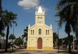
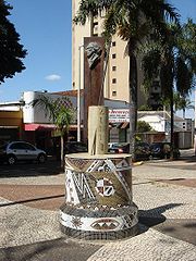
Uberlândia
Encyclopedia

Triângulo Mineiro
The Triangle Mineiro Portuguese pronunciation: [tɾiɐɡulu minejru] is an officer in the region west of the state of Minas Gerais, Brazil. The area is 93.500 km ² and is limited by the Serra da Canastra and Marcela, east, south of Sao Paulo, Goias in the north and west of the junction of the rivers...
) region, west of the state of Minas Gerais, Brazil
Brazil
Brazil , officially the Federative Republic of Brazil , is the largest country in South America. It is the world's fifth largest country, both by geographical area and by population with over 192 million people...
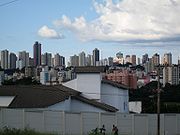
. With a population of 604,013 inhabitants, according to 2010 estimates, the city is the second largest in the state second only to Belo Horizonte (2,375,244). The city's name means Fertile Earth.
Location
Minas Gerais
Minas Gerais is one of the 26 states of Brazil, of which it is the second most populous, the third richest, and the fourth largest in area. Minas Gerais is the Brazilian state with the largest number of Presidents of Brazil, the current one, Dilma Rousseff, being one of them. The capital is the...
, in the region called Triângulo Mineiro
Triângulo Mineiro
The Triangle Mineiro Portuguese pronunciation: [tɾiɐɡulu minejru] is an officer in the region west of the state of Minas Gerais, Brazil. The area is 93.500 km ² and is limited by the Serra da Canastra and Marcela, east, south of Sao Paulo, Goias in the north and west of the junction of the rivers...
, one of the richest agricultural regions of Brazil, between the Paranaíba and Grande rivers. It is connected to major cities by the following federal highways: BR-050, BR-365, BR-455, BR-452, and BR-497. Uberlândia is about 580 km away from São Paulo
São Paulo
São Paulo is the largest city in Brazil, the largest city in the southern hemisphere and South America, and the world's seventh largest city by population. The metropolis is anchor to the São Paulo metropolitan area, ranked as the second-most populous metropolitan area in the Americas and among...
, connected by a modern and safe double trace highway (BR-050). The capital of the state of Minas Gerais, Belo Horizonte
Belo Horizonte
Belo Horizonte is the capital of and largest city in the state of Minas Gerais, located in the southeastern region of Brazil. It is the third largest metropolitan area in the country...
, is 560 km away and Brasília
Brasília
Brasília is the capital city of Brazil. The name is commonly spelled Brasilia in English. The city and its District are located in the Central-West region of the country, along a plateau known as Planalto Central. It has a population of about 2,557,000 as of the 2008 IBGE estimate, making it the...
, the capital of the country, lies just 440 km to the north. There are railways connecting Uberlândia via the north-south Centro-Atlântica line.
Statistical Micro-region
Uberlândia is a statistical micro-region including the following municipalities: AraguariAraguari
Araguari is a city and municipality in northwestern Minas Gerais state, Brazil. It is located in the northern Triângulo Mineiro region, on the Jordão River, a tributary of the Paranaíba River, at an elevation between 940 and 1,087 meters....
, Araporã
Araporã
Araporã is a Brazilian municipality located in the west of the state of Minas Gerais. Its population as of 2007 was 6,113 people living in a total area of 298 km². The city belongs to the statistical mesoregion of Triângulo Mineiro and Alto Paranaíba and to the microregion of Uberlândia...
, Canápolis
Canápolis
Canápolis is a Brazilian municipality located in the west of the state of Minas Gerais. Its population as of 2007 was 11,313 living in a total area of 845 km². The city belongs to the statistical mesoregion of Triângulo Mineiro and Alto Paranaíba and to the statistical microregion of Uberlândia. ...
, Cascalho Rico
Cascalho Rico
Cascalho Rico is a Brazilian municipality located in the west of the state of Minas Gerais. Its population as of 2007 was 2,799 living in a total area of 368 km². The city belongs to the statistical mesoregion of Triângulo Mineiro and Alto Paranaíba and to the statistical microregion of Uberlândia....
, Centralina
Centralina, Minas Gerais
Centralina is a Brazilian municipality located in the west of the state of Minas Gerais. Its population as of 2007 was 10,219 living in a total area of 322 km². The city belongs to the statistical mesoregion of Triângulo Mineiro and Alto Paranaíba and to the statistical microregion of Uberlândia. ...
, Indianópolis
Indianópolis
Indianópolis is a Brazilian municipality located in the west of the state of Minas Gerais. Its population as of 2007 was 6,244 living in a total area of 834 km². The city belongs to the statistical mesoregion of Triângulo Mineiro and Alto Paranaíba and to the statistical microregion of Uberlândia. ...
, Monte Alegre de Minas
Monte Alegre de Minas
Monte Alegre de Minas is a Brazilian municipality located in the west of the state of Minas Gerais. Its population as of 2007 was 18,348 living in a total area of 2,593 km². The city belongs to the statistical mesoregion of Triângulo Mineiro and Alto Paranaíba and to the statistical microregion of...
, Prata, Tupaciguara
Tupaciguara
Tupaciguara is a Brazilian municipality located in the west of the state of Minas Gerais. Its population as of 2007 was 23,076 living in a total area of 1,826 km². The city belongs to the statistical mesoregion of Triângulo Mineiro and Alto Paranaíba and to the statistical microregion of...
, and Uberlândia. In 2007 the population of these cities' agglomeration was 818,395 inhabitants in a total area of 18,864.20 km². The population density (2000) was 43.38 inhab/km².
Infrastructure
With its strategic location in the central region of Brazil, the city has some of the best logistics infrastructure in the country: there are eight highways, with one being transformed into a four lane highway, the FEPASA railway, more than 1.6 million tons capacity of cereal storage, and more than five thousand trucks to deliver products to companies.Self-sufficient in electric power, Uberlândia relies on 12 large power plants in operation and two more under construction in a radius of 250 km.
Ten. Cel. Av. César Bombonato Airport
Uberlândia Airport
Uberlândia – Ten. Cel. Av. César Bombonato Airport is the airport serving Uberlândia, Brazil. Since 2001 the airport is named after the Uberlândia-born pilot of the Brazilian Air Force César Bombonato , who died on an air crash....
is the second largest facility in Minas Gerais and the 27th largest in Brazil in number of passengers transported, with direct flights operating to São Paulo, Belo Horizonte, Goiânia, Brasília, Ribeirão Preto, Uberaba and charter flights to the state capitals of Northeast Brazil in the high season.
The city has several colleges and many universities, among these is the Universidade Federal de Uberlândia
Federal University of Uberlândia
The Federal University of Uberlândia is an institution in the southwest of Minas Gerais, Brazil. It is a public university located in Uberlândia...
, which has a university population of approximately thirty thousand students and is one of the most important universities in the country.
Economic importance in Brazil
Uberlândia is the main economic center of this region. It is the eighth city in the country in payment of federal taxes and the twentieth considering all the taxes. It is the third city in Minas Gerais in state taxes, after the capital Belo Horizonte
Belo Horizonte
Belo Horizonte is the capital of and largest city in the state of Minas Gerais, located in the southeastern region of Brazil. It is the third largest metropolitan area in the country...
and the municipality of Betim
Betim
Betim is a city in Minas Gerais, Brazil. It is located at around . The city belongs to the mesoregion Metropolitan of Belo Horizonte and to the microregion of Belo Horizonte....
, where several automobile assembly plants are located.
Because of its centrality and good transport links Uberlândia has been chosen as a distribution point for the Free Economic Zone of Manaus
Free Economic Zone of Manaus
The Free Economic Zone of Manaus is located in the city of Manaus, the capital of the State of Amazonas, Northern Brazil. The initial idea, a Free Trade Port in Manaus, came from Deputy Francisco Pereira da Silva and was subsequently formalized by Law No. 3.173 on June 6, 1957...
, the first ever such distribution point. http://www.farolcomunitario.com.br/uberlandia_100_0058.htm