

Rodovia Anchieta
Encyclopedia

São Paulo
São Paulo is the largest city in Brazil, the largest city in the southern hemisphere and South America, and the world's seventh largest city by population. The metropolis is anchor to the São Paulo metropolitan area, ranked as the second-most populous metropolitan area in the Americas and among...
and the Atlantic
Atlantic Ocean
The Atlantic Ocean is the second-largest of the world's oceanic divisions. With a total area of about , it covers approximately 20% of the Earth's surface and about 26% of its water surface area...
coast, the cities of Cubatão and Santos
Santos (São Paulo)
-Sister cities: Shimonoseki, Japan Nagasaki, Japan Funchal, Portugal Trieste, Italy Coimbra, Portugal Ansião, Portugal Arouca, Portugal Ushuaia, Argentina Havana, Cuba Taizhou. China Ningbo. China Constanţa, Romania Ulsan, South Korea Colón, Panama* Cadiz, Spain...
, in Brazil
Brazil
Brazil , officially the Federative Republic of Brazil , is the largest country in South America. It is the world's fifth largest country, both by geographical area and by population with over 192 million people...
. In the plateau
Plateau
In geology and earth science, a plateau , also called a high plain or tableland, is an area of highland, usually consisting of relatively flat terrain. A highly eroded plateau is called a dissected plateau...
, the highway serves several cities of Greater São Paulo, such as São Bernardo do Campo
São Bernardo do Campo
São Bernardo do Campo is a municipality in the state of São Paulo, in southern Metropolitan São Paulo and São Paulo microregion. The municipality's total area is 408.45 km ² and a population estimated at 1 July 2009, according to the IBGE, was 810,979 inhabitants, which results in a population...
, São Caetano do Sul
São Caetano do Sul
São Caetano do Sul is a city in São Paulo state in Brazil, located in the Greater São Paulo Metropolitan Area. It is the city with the highest per capita income in Brazil and it also has the highest Human Development Index .-Geography:São Caetano do Sul is located on a plateau that is part of the...
, Santo André and Riacho Grande and traverses a picturesque region of dam
Dam
A dam is a barrier that impounds water or underground streams. Dams generally serve the primary purpose of retaining water, while other structures such as floodgates or levees are used to manage or prevent water flow into specific land regions. Hydropower and pumped-storage hydroelectricity are...
s and rain forests.
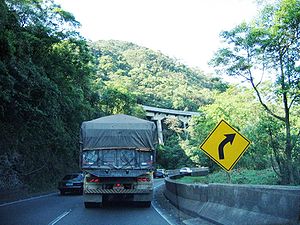
Rodovia Anchieta is a major pride of the Brazilian engineering
Engineering
Engineering is the discipline, art, skill and profession of acquiring and applying scientific, mathematical, economic, social, and practical knowledge, in order to design and build structures, machines, devices, systems, materials and processes that safely realize improvements to the lives of...
, because it was built with a great number of bridge
Bridge
A bridge is a structure built to span physical obstacles such as a body of water, valley, or road, for the purpose of providing passage over the obstacle...
s and tunnels along the steep cliffs of Serra do Mar
Serra do Mar
Serra do Mar is a 1,500 km long system of mountain ranges and escarpments in Southeastern Brazil, which runs in parallel to the Atlantic Ocean coast from the state of Espírito Santo to southern Santa Catarina, although some include Serra Geral in the Serra do Mar, in which case this range...
; and the first modern, concrete
Concrete
Concrete is a composite construction material, composed of cement and other cementitious materials such as fly ash and slag cement, aggregate , water and chemical admixtures.The word concrete comes from the Latin word...
-paved road built in São Paulo in the 1930s.
The highway is one of the busiest of the country, because of the movement of goods to and from Santos's seaport. Traffic problems are common, mainly if there is bad weather
Weather
Weather is the state of the atmosphere, to the degree that it is hot or cold, wet or dry, calm or stormy, clear or cloudy. Most weather phenomena occur in the troposphere, just below the stratosphere. Weather refers, generally, to day-to-day temperature and precipitation activity, whereas climate...
or in long weekends when many families living in São Paulo go to Santos or Guarujá
Guarujá
Guarujá is a municipality in the São Paulo state of Brazil. The population in 2006 was 305,171, the population density is 1,969.47/km² and the area is 143 km². This place name comes from the Tupi language, and mean "narrow path". The population is highly urbanized.-Geography:Guarujá is...
beach
Beach
A beach is a geological landform along the shoreline of an ocean, sea, lake or river. It usually consists of loose particles which are often composed of rock, such as sand, gravel, shingle, pebbles or cobblestones...
es. Rodovia Anchieta is approximately 60 km long.
It is named after the Jesuit priest, Father José de Anchieta
José de Anchieta
José de Anchieta was a Canarian Jesuit missionary to Brazil in the second half of the 16th century. A highly influential figure in Brazil's history in the 1st century after its discovery on April 22, 1500 by a Portuguese fleet commanded by Pedro Álvares Cabral, Anchieta was one of the founders of...
who often used the simple forest trek that connected to city of São Vicente
São Vicente, São Paulo
São Vicente is a coastal city of southern São Paulo, Brazil. Its estimated population in 2006 was 329,370 inhabitants.It was the first Portuguese permanent settlement in the Americas and the first capital of the Captaincy of São Vicente, now the state of São Paulo...
by the sea with the village he helped to found in the high plateau, São Paulo dos Campos de Piratininga
São Paulo dos Campos de Piratininga
São Paulo dos Campos de Piratininga was the village that grew into São Paulo, Brazil in the region known as Campos de Piratininga...
, in 1554.
The highway is managed by a state concession to the private company Ecovias, and therefore is a toll road
Toll road
A toll road is a privately or publicly built road for which a driver pays a toll for use. Structures for which tolls are charged include toll bridges and toll tunnels. Non-toll roads are financed using other sources of revenue, most typically fuel tax or general tax funds...
.
The two carriageways of Rodovia Anchieta are both fully reversible
Reversible lane
A reversible lane , called a counterflow lane or contraflow lane in transport engineering nomenclature, is a lane in which traffic may travel in either direction, depending on certain conditions...
. Traffic is managed to flow either bidirectionally (uphill on one carriageway and downhill on the other) or unidirectionally (uphill or downhill on both carriageways), depending on demand. In the unidirectional mode, the opposing traffic is diverted to Rodovia dos Imigrantes
Rodovia dos Imigrantes
Rodovia dos Imigrantes is a highway in the state of São Paulo, Brazil.The highway connects the city of São Paulo to the Atlantic coast and with the seaside cities of São Vicente and Praia Grande. It follows the route of Rodovia Anchieta and is also one of Brazil's busiest highways, particularly on...
.
See also
- Highway system of São PauloHighway system of São PauloThe highway system of São Paulo is the largest statewide road transportation system in Brazil, with 34,650 km. It consists of a hugely interconnected network of municipal , state and federal roads...
- Brazilian Highway SystemBrazilian Highway SystemThe Brazilian Highway System is the highway system of Brazil, the fourth largest in the World. As of 2010, the system consists of almost 2 million kilometers of roads, of which approximately 200,000 km are paved.As it is in the United States, Canada or most countries in Europe, larger/wider...