

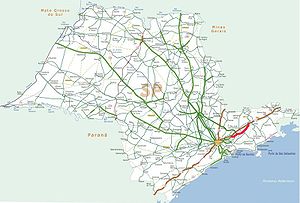
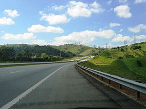
Rodovia Carvalho Pinto
Encyclopedia
Highway
A highway is any public road. In American English, the term is common and almost always designates major roads. In British English, the term designates any road open to the public. Any interconnected set of highways can be variously referred to as a "highway system", a "highway network", or a...
in the state of São Paulo
São Paulo (state)
São Paulo is a state in Brazil. It is the major industrial and economic powerhouse of the Brazilian economy. Named after Saint Paul, São Paulo has the largest population, industrial complex, and economic production in the country. It is the richest state in Brazil...
, Brazil
Brazil
Brazil , officially the Federative Republic of Brazil , is the largest country in South America. It is the world's fifth largest country, both by geographical area and by population with over 192 million people...
.
It is a continuation of the Rodovia Ayrton Senna
Rodovia Ayrton Senna
Rodovia Ayrton Senna da Silva , is a highway in the state of São Paulo, Brazil....
(also SP-070), near the city of Guararema
Guararema
Guararema is a municipality in the state of São Paulo in Brazil. The population in 2006 was 24,818, with a density of 91.7 inh./km² and the area is 271 km². This place name comes from the Tupi language. It is a suburb of São Paulo....
and ends by merging with Rodovia Presidente Dutra
Rodovia Presidente Dutra
The Rodovia Presidente Dutra, , colloquially known as Via Dutra is a federal highway which runs through the eastern part of the state of São Paulo and southwestern region of the state Rio de Janeiro...
, which connects the cities of São Paulo and Rio de Janeiro
Rio de Janeiro
Rio de Janeiro , commonly referred to simply as Rio, is the capital city of the State of Rio de Janeiro, the second largest city of Brazil, and the third largest metropolitan area and agglomeration in South America, boasting approximately 6.3 million people within the city proper, making it the 6th...
; and Rodovia Floriano Rodrigues Pinheiro
Rodovia Floriano Rodrigues Pinheiro
Rodovia Floriano Rodrigues Pinheiro is a single-lane highway in the state of São Paulo, Brazil. It connects the Rodovia Carvalho Pinto and the Rodovia Presidente Dutra nearby the city of Taubaté, to the mountain resort of Campos do Jordão.SP-123 is one of the most scenic roads in the state...
(SP-123), which connects Taubaté
Taubaté
Taubaté is a city in the State of São Paulo, in southeastern Brazil. Its strategic geographical location, between the two most important Brazilian cities , being crossed by Presidente Dutra Highway which connects the two megacities, and between high, cold mountains and the Atlantic Ocean has...
to Campos do Jordão
Campos do Jordão
Campos do Jordão is a municipality in the state of São Paulo in Brazil. The population in 2003 was 47,903 and the area is 290.27 km². The elevation is 1,628 m....
. The cities served by the highway are Guararema
Guararema
Guararema is a municipality in the state of São Paulo in Brazil. The population in 2006 was 24,818, with a density of 91.7 inh./km² and the area is 271 km². This place name comes from the Tupi language. It is a suburb of São Paulo....
, Jacareí
Jacareí
Jacareí is a city of approximately 211,308 inhabitants in the state of São Paulo, Brazil. The name comes from a native brazilan language . It's a word that means something like "the rivers where alligators are found"....
, São José dos Campos
São José dos Campos
São José dos Campos is a municipality and a major city in the state of São Paulo, Brazil and one of the most important industrial and research centers in Latin America. It is located in the Paraíba Valley, between the two most active production and consumption regions in the country, São Paulo ...
, Caçapava
Caçapava
Caçapava is a municipality in the state of São Paulo in Brazil. The population in 2004 was 81,298 and the area was 370.87 km². The elevation is 560 m. The city lies between Taubaté and São José dos Campos....
and Taubaté.
The highway was built in order to relieve the traffic saturation of the Presidente Dutra Highway, and is the main thoroughfare used by the paulistas
Paulistas
Paulistas are the inhabitants of the state of São Paulo, Brazil, and of its antecessor the Capitaincy of São Vicente, whose capital early shifted from the village of São Vicente to the one of São Paulo dos Campos de Piratininga....
who wish to travel to the beach
Beach
A beach is a geological landform along the shoreline of an ocean, sea, lake or river. It usually consists of loose particles which are often composed of rock, such as sand, gravel, shingle, pebbles or cobblestones...
es and cities near the South Atlantic Ocean of the Northern coast of the state (Rodovia dos Tamoios
Rodovia dos Tamoios
Rodovia dos Tamoios is a highway in the Brazilian state of São Paulo.The highway is partly dual-lane, part single-lane, and runs from the city of São José dos Campos, located in the Paraíba River valley in the upper plateau of São Paulo down the Serra do Mar to the coastal lowlands of the city of...
, SP-099), as well as to other cities of the Paraíba River
Paraíba do Sul
thumbThe Paraíba do Sul , or simply termed Paraíba, is a river in the south-east of Brazil. It flows 1,137 kilometres west to northeast from its farthest source at the source of the river Paraitinga to the sea near Campos...
valley, such as Paraibuna
Paraibuna
Paraibuna is a municipality in the state of São Paulo in Brazil. The population in 2004 is 18,096 and the area is 811.76 km². The elevation is 635 m...
and Jambeiro
Jambeiro
Jambeiro is a municipality in the state of São Paulo in Brazil. The population in 2004 is 4,355 and the area is 184.28 km². The elevation is 695 m.-External links:*...
on the plateau
Plateau
In geology and earth science, a plateau , also called a high plain or tableland, is an area of highland, usually consisting of relatively flat terrain. A highly eroded plateau is called a dissected plateau...
of Serra do Mar
Serra do Mar
Serra do Mar is a 1,500 km long system of mountain ranges and escarpments in Southeastern Brazil, which runs in parallel to the Atlantic Ocean coast from the state of Espírito Santo to southern Santa Catarina, although some include Serra Geral in the Serra do Mar, in which case this range...
, and to the mountain resort
Resort
A resort is a place used for relaxation or recreation, attracting visitors for holidays or vacations. Resorts are places, towns or sometimes commercial establishment operated by a single company....
s in the Mantiqueira mountain range, such as Santo Antonio do Pinhal
Santo Antônio do Pinhal
Santo Antônio do Pinhal is a municipality in the state of São Paulo in Brazil. The population in 2004 was 6,827 and the area is 133.27 km². The elevation is 1,080 m ....
and Campos do Jordão
Campos do Jordão
Campos do Jordão is a municipality in the state of São Paulo in Brazil. The population in 2003 was 47,903 and the area is 290.27 km². The elevation is 1,628 m....
, via the Rodovia Floriano Rodrigues Pinheiro
Rodovia Floriano Rodrigues Pinheiro
Rodovia Floriano Rodrigues Pinheiro is a single-lane highway in the state of São Paulo, Brazil. It connects the Rodovia Carvalho Pinto and the Rodovia Presidente Dutra nearby the city of Taubaté, to the mountain resort of Campos do Jordão.SP-123 is one of the most scenic roads in the state...
.
The highway honours one of the former governors of the state of São Paulo, Carlos Alberto Alves de Carvalho Pinto.
It is managed and maintained by DERSA, a state-owned company, and is a toll road
Toll road
A toll road is a privately or publicly built road for which a driver pays a toll for use. Structures for which tolls are charged include toll bridges and toll tunnels. Non-toll roads are financed using other sources of revenue, most typically fuel tax or general tax funds...
.
See also
- Highway system of São PauloHighway system of São PauloThe highway system of São Paulo is the largest statewide road transportation system in Brazil, with 34,650 km. It consists of a hugely interconnected network of municipal , state and federal roads...
- Brazilian Highway SystemBrazilian Highway SystemThe Brazilian Highway System is the highway system of Brazil, the fourth largest in the World. As of 2010, the system consists of almost 2 million kilometers of roads, of which approximately 200,000 km are paved.As it is in the United States, Canada or most countries in Europe, larger/wider...