
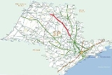
Rodovia Washington Luís
Encyclopedia
| SP-310 | |
|---|---|
Rodovia Washington Luís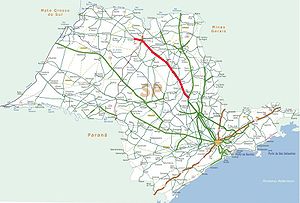 |
|
| Length | 301 km (187 mi) |
| General direction | South-North |
| From | Rodovia Anhanguera Rodovia Anhangüera Rodovia Anhangüera is a highway in the state of São Paulo, Brazil. It is one of the country's busiest transportation corridors... , km 153, in the city of Limeira Limeira Limeira is a city in the eastern part of the Brazilian state of São Paulo. The population in 2004 is 270,733 and the area is 582.48 km². The elevation is 588 m. It is 154 km far from São Paulo, the state capital, and 1011 km far from Brasilia, Brazil's capital... |
| To | Rodovia Transbrasiliana Rodovia Transbrasiliana Rodovia Transbrasiliana is a federal highway in Brazil .It crosses Brazil in the North-South direction, starting in Marabá, state of Pará and ending in Aceguá, in the state of Rio Grande do Sul... , in the city of São José do Rio Preto São José do Rio Preto São José do Rio Preto is a city and municipality in the state of São Paulo, Brazil. Is located at the north/northwest portion of the state, 450 km from the city of São Paulo and 700 km from Brasília.... |
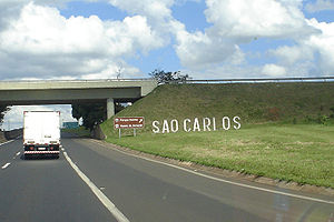
| Major cities | Limeira Limeira Limeira is a city in the eastern part of the Brazilian state of São Paulo. The population in 2004 is 270,733 and the area is 582.48 km². The elevation is 588 m. It is 154 km far from São Paulo, the state capital, and 1011 km far from Brasilia, Brazil's capital... , Cordeirópolis Cordeirópolis Cordeirópolis is a small town in São Paulo state, Brazil. The town has 20,445 inhabitants, as of 2008.... , Santa Gertrudes Santa Gertrudes Santa Gertrudes is a municipality in the state of São Paulo in Brazil. The population in 2004 was 18,687 and the area is 97.7 km². The elevation is 595 m.... , Rio Claro Rio Claro Rio Claro may refer to:-Cities:*Rio Claro, Trinidad and Tobago, the largest town in southeastern Trinidad and Tobago... , Corumbataí Corumbataí Corumbataí is a municipality in the state of São Paulo in Brazil. The population in 2004 is 4,121 and the area is 278.96 km². The elevation is 608 m.... , São Carlos São Carlos São Carlos is a city of 221,950 inhabitants in the state of São Paulo, Brazil. It is located at , at about 231 km from the city of São Paulo.-History:... , Ibaté Ibaté Ibaté is a municipality in the state of São Paulo, Brazil. The population is of 30,734 inhabitants . The city's name comes from the Tupi language and means "dry lake".... , Araraquara Araraquara Not to be confused with Araracuara, a town, region, genus of trees in ColombiaAraraquara is a city in the state of São Paulo in Brazil. It is also known as "the abode of the sun," because of its impressive sunset and because of its hazy temperature, especially in summer.More than 200,000 people... , Matão Matão Matão is a city in the state of São Paulo in Brazil. The population in 2004 is 75,929 and the area is 528.44 km². The elevation is 585 m.-Corpus Christi Feast:... , Taquaritinga Taquaritinga Taquaritinga is a city in the Central North area of the State of São Paulo, Brazil. It has around 54,000 inhabitants , more than 90% of them living in the urban area.... , Catanduva Catanduva Catanduva is a municipality in the state of São Paulo, Brazil. Is the 2nd largest city in the North/Northwest portion of the state, 385 km from the city of São Paulo... , Catiguá Catiguá Catiguá is a municipality in the state of São Paulo in Brazil. The population in 2004 is 6,706 and the area is 145.86 km². The elevation is 483 m.... , Ibirá Ibirá Ibirá is a municipality in the state of São Paulo, Brazil. The population is of 10,896 inhabitants . The city has an area of 271.9 km²... , Uchoa Uchoa Uchoa is a municipality in the state of São Paulo, Brazil. The population is of 9,471 inhabitants and the area is 252.5 km². Uchoa belongs to the Mesoregion of São José do Rio Preto.-Economy:... , Cedral Cedral Cedral is a municipality in the state of São Paulo, Brazil. The population is 7.972 inhabitants .The city belongs to the Mesoregion and Microregion of São José do Rio Preto.-Demographics:The life expectancy for the city is 75.15 years.... , São José do Rio Preto São José do Rio Preto São José do Rio Preto is a city and municipality in the state of São Paulo, Brazil. Is located at the north/northwest portion of the state, 450 km from the city of São Paulo and 700 km from Brasília.... . |
| Major highway junctions | -SP 330 (Rodovia Anhanguera Rodovia Anhangüera Rodovia Anhangüera is a highway in the state of São Paulo, Brazil. It is one of the country's busiest transportation corridors... ), km 153 -SP 348 (Rodovia dos Bandeirantes Rodovia dos Bandeirantes Rodovia Bandeirantes is a highway in the state of São Paulo, Brazil.Once the traffic capacity of Anhangüera Highway was exceeded in the 1960s, the state government decided to built another highway, with a much higher capacity and modern design, directly connecting São Paulo City to Jundiaí,... ), km 156 -SP 225 (Rodovia Eng° Paulo Nilo Romano) and (Rodovia Deputado Rogê Ferreira), km 206 -SP 215 (Rodovia Dr. Paulo Lauro e Dep. Vicente Botta and Rodovia Luís Augusto de Oliveira), km 227 -SP 318 (Rodovia Thales de Lorena Peixoto Junior), 235,4 -SP 255 (Rodovia Antônio Machado Sant'Anna) and (Rodovia Comendador João Ribeiro de Barros), km 271 -SP 326 (Rodovia Brigadeiro Faria Lima Rodovia Brigadeiro Faria Lima Rodovia Brigadeiro Faria Lima is a highway in the state of São Paulo, Brazil.SP-326 is a full four-lane highway connecting the cities of Bebedouro and Barretos, serving also the city of Colina, and runs in the Southeast to Northeast direction. It is managed and maintained through a state... ), km 293 -SP 319 (Rodovia Thyrso Micali), km 321 -SP 425/BR 153 (Rodovia Transbrasiliana Rodovia Transbrasiliana Rodovia Transbrasiliana is a federal highway in Brazil .It crosses Brazil in the North-South direction, starting in Marabá, state of Pará and ending in Aceguá, in the state of Rio Grande do Sul... ), km 439 |
| Established | 1953/1959/1961 |
| System | From Limeira Limeira Limeira is a city in the eastern part of the Brazilian state of São Paulo. The population in 2004 is 270,733 and the area is 582.48 km². The elevation is 588 m. It is 154 km far from São Paulo, the state capital, and 1011 km far from Brasilia, Brazil's capital... to Rio Claro Rio Claro Rio Claro may refer to:-Cities:*Rio Claro, Trinidad and Tobago, the largest town in southeastern Trinidad and Tobago... four lane highway, from Rio Claro Rio Claro Rio Claro may refer to:-Cities:*Rio Claro, Trinidad and Tobago, the largest town in southeastern Trinidad and Tobago... to São Carlos São Carlos São Carlos is a city of 221,950 inhabitants in the state of São Paulo, Brazil. It is located at , at about 231 km from the city of São Paulo.-History:... four and five lane highway, from São Carlos São Carlos São Carlos is a city of 221,950 inhabitants in the state of São Paulo, Brazil. It is located at , at about 231 km from the city of São Paulo.-History:... to São José do Rio Preto São José do Rio Preto São José do Rio Preto is a city and municipality in the state of São Paulo, Brazil. Is located at the north/northwest portion of the state, 450 km from the city of São Paulo and 700 km from Brasília.... four and five lane highway. |
Highway
A highway is any public road. In American English, the term is common and almost always designates major roads. In British English, the term designates any road open to the public. Any interconnected set of highways can be variously referred to as a "highway system", a "highway network", or a...
in the state of São Paulo
São Paulo (state)
São Paulo is a state in Brazil. It is the major industrial and economic powerhouse of the Brazilian economy. Named after Saint Paul, São Paulo has the largest population, industrial complex, and economic production in the country. It is the richest state in Brazil...
, Brazil
Brazil
Brazil , officially the Federative Republic of Brazil , is the largest country in South America. It is the world's fifth largest country, both by geographical area and by population with over 192 million people...
.
It runs in the North-Northwest direction, departing as a branch from the Anhangüera Highway near the city of Limeira
Limeira
Limeira is a city in the eastern part of the Brazilian state of São Paulo. The population in 2004 is 270,733 and the area is 582.48 km². The elevation is 588 m. It is 154 km far from São Paulo, the state capital, and 1011 km far from Brasilia, Brazil's capital...
. It also crosses with the Rodovia dos Bandeirantes
Rodovia dos Bandeirantes
Rodovia Bandeirantes is a highway in the state of São Paulo, Brazil.Once the traffic capacity of Anhangüera Highway was exceeded in the 1960s, the state government decided to built another highway, with a much higher capacity and modern design, directly connecting São Paulo City to Jundiaí,...
, nearby the city of Cordeirópolis
Cordeirópolis
Cordeirópolis is a small town in São Paulo state, Brazil. The town has 20,445 inhabitants, as of 2008....
.
Main cities linked by the Washington Luís Highway are Rio Claro
Rio Claro, São Paulo
Rio Claro is a city in the state of São Paulo in Brazil. The population in 2005 was 195,131 and the area is 521 km². The elevation is 613 m. It was incorporated as the village of São João Batista do Ribeirão Claro in 1827, and this incorporation is celebrated every year on June 24 as a municipal...
, São Carlos
São Carlos
São Carlos is a city of 221,950 inhabitants in the state of São Paulo, Brazil. It is located at , at about 231 km from the city of São Paulo.-History:...
, Araraquara
Araraquara
Not to be confused with Araracuara, a town, region, genus of trees in ColombiaAraraquara is a city in the state of São Paulo in Brazil. It is also known as "the abode of the sun," because of its impressive sunset and because of its hazy temperature, especially in summer.More than 200,000 people...
, Catanduva
Catanduva
Catanduva is a municipality in the state of São Paulo, Brazil. Is the 2nd largest city in the North/Northwest portion of the state, 385 km from the city of São Paulo...
, São José do Rio Preto
São José do Rio Preto
São José do Rio Preto is a city and municipality in the state of São Paulo, Brazil. Is located at the north/northwest portion of the state, 450 km from the city of São Paulo and 700 km from Brasília....
and Mirassol
Mirassol
Mirassol is a city and municipality in the state of São Paulo, Brazil. The city is located on the north/northwest portion of the state, 463 km from the city of São Paulo and 15 km from São José do Rio Preto...
.
Iit is named in honor of Washington Luís Pereira de Sousa
Washington Luís Pereira de Sousa
Washington Luís Pereira de Sousa was a Brazilian politician. His family was of Portuguese Romani descent. He was born in Macaé, Rio de Janeiro, and moved to São Paulo, where he became a lawyer. Elected governor of São Paulo state in 1920 and president of Brazil in 1926, Washington Luís was the...
(1869-1957), one of the presidents of Brazil and a paulista
Paulistas
Paulistas are the inhabitants of the state of São Paulo, Brazil, and of its antecessor the Capitaincy of São Vicente, whose capital early shifted from the village of São Vicente to the one of São Paulo dos Campos de Piratininga....
, who famously declared in 1926 that "to govern is to build roads".
The highway is managed and maintained through a state concession to the private companies Centrovias and Triângulo do Sol, and therefore is a toll road
Toll road
A toll road is a privately or publicly built road for which a driver pays a toll for use. Structures for which tolls are charged include toll bridges and toll tunnels. Non-toll roads are financed using other sources of revenue, most typically fuel tax or general tax funds...
.
From Mirassol to Ilha Solteira
Ilha Solteira
Ilha Solteira is a municipality in the state of São Paulo in Brazil. The population in 2004 is 25,168 and the area is 661.34 km². The elevation is 335 m. This city was named after the nearby Ilha Solteira Dam....
, the code is the same but the name is changed to "Feliciano Sales Cunha".
There is another highway so named in Brazil, in the state of Rio de Janeiro
Rio de Janeiro
Rio de Janeiro , commonly referred to simply as Rio, is the capital city of the State of Rio de Janeiro, the second largest city of Brazil, and the third largest metropolitan area and agglomeration in South America, boasting approximately 6.3 million people within the city proper, making it the 6th...
, between that city and Petrópolis
Petrópolis
Petrópolis , also known as The Imperial City of Brazil, is a town in the state of Rio de Janeiro, about 65 km from the city of Rio de Janeiro....
.
Highway description
- km 153 - The highway start at Rodovia AnhangüeraRodovia AnhangüeraRodovia Anhangüera is a highway in the state of São Paulo, Brazil. It is one of the country's busiest transportation corridors...
- km 153 - The start of administration Centrovias
- km 155 - Weighing scaleWeighing scaleA weighing scale is a measuring instrument for determining the weight or mass of an object. A spring scale measures weight by the distance a spring deflects under its load...
(north and south way) - km 156 - Exit to Rodovia dos BandeirantesRodovia dos BandeirantesRodovia Bandeirantes is a highway in the state of São Paulo, Brazil.Once the traffic capacity of Anhangüera Highway was exceeded in the 1960s, the state government decided to built another highway, with a much higher capacity and modern design, directly connecting São Paulo City to Jundiaí,...
- km 159 - Exit to CordeirópolisCordeirópolisCordeirópolis is a small town in São Paulo state, Brazil. The town has 20,445 inhabitants, as of 2008....
- km 161 - Speedtrap (north way)
- km 165 - Exit to Santa GertrudesSanta GertrudesSanta Gertrudes is a municipality in the state of São Paulo in Brazil. The population in 2004 was 18,687 and the area is 97.7 km². The elevation is 595 m....
- km 173 - Highway Police
- km 173 - Exit to Rio ClaroRio ClaroRio Claro may refer to:-Cities:*Rio Claro, Trinidad and Tobago, the largest town in southeastern Trinidad and Tobago...
- km 173 - Exit to PiracicabaPiracicabaPiracicaba is a city located in the Brazilian state of São Paulo. The population in 2009 was 368,843 in an area of 1,369.511 km², at an elevation of 547 m above sea level.-Name:...
(36 km) - km 173,840 - Speedtrap (north way)
- km 175,345 - Speedtrap (south way)
- km 180 - Exit to São PedroSão PedroSão Pedro is Portuguese for Saint Peter in Portugal and Brazil, and may also refer to:-Brazil:* São Pedro, Rio Grande do Norte, a municipality in the State of Rio Grande do Norte* São Pedro, São Paulo, a municipality in the State of São Paulo...
(51 km) - km 181 - Toll roadToll roadA toll road is a privately or publicly built road for which a driver pays a toll for use. Structures for which tolls are charged include toll bridges and toll tunnels. Non-toll roads are financed using other sources of revenue, most typically fuel tax or general tax funds...
Rio ClaroRio ClaroRio Claro may refer to:-Cities:*Rio Claro, Trinidad and Tobago, the largest town in southeastern Trinidad and Tobago...
(south way) - km 182 - Speedtrap (south way)
- km 184,396 - Speedtrap (south way)
- km 184,400 - SAU (south way)
- km 194,600 - Speedtrap (south way)
- km 198 - Highway Police
- km 199 - Exit to CorumbataíCorumbataíCorumbataí is a municipality in the state of São Paulo in Brazil. The population in 2004 is 4,121 and the area is 278.96 km². The elevation is 608 m....
- km 199,900 - Speedtrap (south way)
- km 200,150 - Weighing scaleWeighing scaleA weighing scale is a measuring instrument for determining the weight or mass of an object. A spring scale measures weight by the distance a spring deflects under its load...
- km 200,150 - SAU (north way)
- km 201,200 - Weighing scaleWeighing scaleA weighing scale is a measuring instrument for determining the weight or mass of an object. A spring scale measures weight by the distance a spring deflects under its load...
(south way) - km 205,850 - Speedtrap (north way)
- km 207 - Exit to (SP-225SP-225SP-225 is a state highway in the state of São Paulo in Brazil. Part of it consists of the Rodovia Nilo Paulo Romano and Rodovia Dep. Rogê Ferreira....
) by AnalândiaAnalândiaAnalândia is a Brazilian city of the state of São Paulo. The population in 2004 is 3,870. The area is 327.532 km².It was the location of the Brazilian version of The Simple Life....
(16 km), PirassunungaPirassunungaPirassununga is a municipality in the state of São Paulo in Brazil. The population in 2010 was 70.081 and the area is 728.78 km². The elevation is 627 m. This place name comes from the Tupi language....
(41 km) - km 207 - Exit to (SP-225SP-225SP-225 is a state highway in the state of São Paulo in Brazil. Part of it consists of the Rodovia Nilo Paulo Romano and Rodovia Dep. Rogê Ferreira....
) by ItirapinaItirapinaItirapina is a municipality in the state of São Paulo in Brazil. The population in 2004 is 14,315 and the area is 565.78 km². The elevation is 770 m. This place name comes from the Tupi language....
, Represa do Broa, BrotasBrotasBrotas is a Brazilian municipality located in the state of São Paulo. Its estimated population in 2004 was 21,187.The town its known locally for its coffee, on which its economy relies.-History:...
(34 km), JaúJaúJaú is a municipality in the center of the state of São Paulo, in Brazil. The population in 2008 was 133,333 and the area is 690.18 km². The elevation is 522 m...
(85 km) and BauruBauruBauru is a Brazilian city and municipality in midwestern region of the state of São Paulo. It is also the capital of the micro-region of Bauru... - km 209 - Weighing scaleWeighing scaleA weighing scale is a measuring instrument for determining the weight or mass of an object. A spring scale measures weight by the distance a spring deflects under its load...
(north way) - km 214,100 - Weighing scaleWeighing scaleA weighing scale is a measuring instrument for determining the weight or mass of an object. A spring scale measures weight by the distance a spring deflects under its load...
(south way) - km 217 - Toll roadToll roadA toll road is a privately or publicly built road for which a driver pays a toll for use. Structures for which tolls are charged include toll bridges and toll tunnels. Non-toll roads are financed using other sources of revenue, most typically fuel tax or general tax funds...
ItirapinaItirapinaItirapina is a municipality in the state of São Paulo in Brazil. The population in 2004 is 14,315 and the area is 565.78 km². The elevation is 770 m. This place name comes from the Tupi language....
/ São CarlosSão CarlosSão Carlos is a city of 221,950 inhabitants in the state of São Paulo, Brazil. It is located at , at about 231 km from the city of São Paulo.-History:...
(north way) - km 217,080 - SAU (south way)
- km 222 - Southbound - Castelo Road Services Plaza
- km 222 - Southbound - Hotel Pousadas Conde do Pinhal
- km 225,060 - Speedtrap (north way)
- km 227,800 - The end of administration Centrovias
- km 227,800 - The start of administration Triângulo do Sol
- km 227,900 - Exit to São CarlosSão CarlosSão Carlos is a city of 221,950 inhabitants in the state of São Paulo, Brazil. It is located at , at about 231 km from the city of São Paulo.-History:...
by (SP-215SP-215SP-215 is a state highway in the state of São Paulo in Brazil. Part of it consists of the Rodovia Luís Augusto de Oliveira, Rodovia Dr. Paulo Lauro and Rodovia Deputado Vicente Botta....
) - km 227.900 - Exit to VolkswagenVolkswagenVolkswagen is a German automobile manufacturer and is the original and biggest-selling marque of the Volkswagen Group, which now also owns the Audi, Bentley, Bugatti, Lamborghini, SEAT, and Škoda marques and the truck manufacturer Scania.Volkswagen means "people's car" in German, where it is...
engines - km 227,900 - Exit to (SP-215SP-215SP-215 is a state highway in the state of São Paulo in Brazil. Part of it consists of the Rodovia Luís Augusto de Oliveira, Rodovia Dr. Paulo Lauro and Rodovia Deputado Vicente Botta....
) by Ribeirão BonitoRibeirão BonitoRibeirão Bonito is a municipality in the state of São Paulo in Brazil. The population in 2004 was 11,716 and the area is 472.77 km². The elevation is 590 m....
(33 km), Dourado, São PauloDourado, São PauloDourado is a municipality in the state of São Paulo in Brazil.-See also:*Dourado , different species of fish....
(50 km), JaúJaúJaú is a municipality in the center of the state of São Paulo, in Brazil. The population in 2008 was 133,333 and the area is 690.18 km². The elevation is 522 m...
(85 km) and BauruBauruBauru is a Brazilian city and municipality in midwestern region of the state of São Paulo. It is also the capital of the micro-region of Bauru... - km 227,900 - Exit to (SP-215SP-215SP-215 is a state highway in the state of São Paulo in Brazil. Part of it consists of the Rodovia Luís Augusto de Oliveira, Rodovia Dr. Paulo Lauro and Rodovia Deputado Vicente Botta....
) by DescalvadoDescalvadoDescalvado is a municipality in the state of São Paulo, Brazil. The population in 2003 is 31,056 and the area is 753.7 km².-History:The city was founded firstly as a settlement in the 1880s and was one of the main coffee producer in São Paulo's golden coffee plantation years....
(35 km) and Porto FerreiraPorto FerreiraPorto Ferreira is a municipality in the state of São Paulo in Brazil. The population in 2004 was 52,026 and the area is 244.88 km².It is situated to the edge of the river Mogi-Guaçu, at an altitude of 549 meters. Its population in 2006 was 54 000 inhabitants...
(48 km) - km 228,600 - Exit to São CarlosSão CarlosSão Carlos is a city of 221,950 inhabitants in the state of São Paulo, Brazil. It is located at , at about 231 km from the city of São Paulo.-History:...
(Getúlio Vargas avenue) - km 231 - Exit to São CarlosSão CarlosSão Carlos is a city of 221,950 inhabitants in the state of São Paulo, Brazil. It is located at , at about 231 km from the city of São Paulo.-History:...
- km 231 - Exit to FADISC
- km 231 - Exit to Jardim Tangará and others
- km 231,750 - Exit to São CarlosSão CarlosSão Carlos is a city of 221,950 inhabitants in the state of São Paulo, Brazil. It is located at , at about 231 km from the city of São Paulo.-History:...
- km 231,750 - Exit to Jardim Maria Stella Fagá and others
- km 231,750 - Exit to Estrada da Babilônia (SCA-334)
- km 231,760 - Speedtrap (north way)
- km 232 - Exit to São CarlosSão CarlosSão Carlos is a city of 221,950 inhabitants in the state of São Paulo, Brazil. It is located at , at about 231 km from the city of São Paulo.-History:...
- km 232 - Exit to Vila Santa Maria I, II and São Carlos VIII
- km 232 - Exit to São CarlosSão CarlosSão Carlos is a city of 221,950 inhabitants in the state of São Paulo, Brazil. It is located at , at about 231 km from the city of São Paulo.-History:...
(Vila Nery) - km 233,700 - Highway Police
- km 234 - Exit to São CarlosSão CarlosSão Carlos is a city of 221,950 inhabitants in the state of São Paulo, Brazil. It is located at , at about 231 km from the city of São Paulo.-History:...
(Araraquara avenue) - km 234,200 - FootbridgeFootbridgeA footbridge or pedestrian bridge is a bridge designed for pedestrians and in some cases cyclists, animal traffic and horse riders, rather than vehicular traffic. Footbridges complement the landscape and can be used decoratively to visually link two distinct areas or to signal a transaction...
- km 235 - Exit to UFSCar
- km 235 - Exit to São CarlosSão CarlosSão Carlos is a city of 221,950 inhabitants in the state of São Paulo, Brazil. It is located at , at about 231 km from the city of São Paulo.-History:...
- km 235,400 - Exit to (SP-318SP-318SP-318 is a state highway in the state of São Paulo in Brazil. Part of it consists of the Rodovia Thales de Lorena Peixoto Júnior....
) São Carlos AirportSão Carlos AirportMário Pereira Lopes State Airport is the airport serving São Carlos, Brazil.It is operated by DAESP.-History:The airport was built in the 1970s as a private aerodrome of a Brazilian tractor manufacturer. In 1995 the factory went bankrupt and, as a consequence, its administration was taken over by...
, Wings of a Dream MuseumWings of a Dream MuseumThe TAM Museum , also known as the Museu Asas de um Sonho , is an aviation museum in the city of São Carlos, within the state of São Paulo, Brazil....
and Technology Center of TAM (14 km) - km 235,400 - Exit to (SP-318SP-318SP-318 is a state highway in the state of São Paulo in Brazil. Part of it consists of the Rodovia Thales de Lorena Peixoto Júnior....
) Damha Golf Club (2 km) and Ribeirão PretoRibeirão PretoRibeirão Preto is a municipality and city in the Northeastern region of the state of São Paulo in Brazil. It is nicknamed Brazilian California, because of a combination of an economy based on agrobusiness plus high technology, wealth and sunny weather all year long. With 605,114 inhabitants,...
(91 km) - km 235,800 - Exit to São CarlosSão CarlosSão Carlos is a city of 221,950 inhabitants in the state of São Paulo, Brazil. It is located at , at about 231 km from the city of São Paulo.-History:...
(Luís Augusto de Oliveira avenue) - km 236,500 - Exit to Tecumseh do Brasil
- km 236,500 - Exit to São CarlosSão CarlosSão Carlos is a city of 221,950 inhabitants in the state of São Paulo, Brazil. It is located at , at about 231 km from the city of São Paulo.-History:...
- km 236,750 - FootbridgeFootbridgeA footbridge or pedestrian bridge is a bridge designed for pedestrians and in some cases cyclists, animal traffic and horse riders, rather than vehicular traffic. Footbridges complement the landscape and can be used decoratively to visually link two distinct areas or to signal a transaction...
- km 240 - Exit to São CarlosSão CarlosSão Carlos is a city of 221,950 inhabitants in the state of São Paulo, Brazil. It is located at , at about 231 km from the city of São Paulo.-History:...
- km 240 - Exit to UNICEP and USPUniversity of São PauloUniversidade de São Paulo is a public university in the Brazilian state of São Paulo. It is the largest Brazilian university and one of the country's most prestigious...
II - km 247 - Exit to IbatéIbatéIbaté is a municipality in the state of São Paulo, Brazil. The population is of 30,734 inhabitants . The city's name comes from the Tupi language and means "dry lake"....
- km 253,100 - SAU (north way) IbatéIbatéIbaté is a municipality in the state of São Paulo, Brazil. The population is of 30,734 inhabitants . The city's name comes from the Tupi language and means "dry lake"....
- km 260,150 - Speedtrap (south way)
- km 268 - Exit to AraraquaraAraraquaraNot to be confused with Araracuara, a town, region, genus of trees in ColombiaAraraquara is a city in the state of São Paulo in Brazil. It is also known as "the abode of the sun," because of its impressive sunset and because of its hazy temperature, especially in summer.More than 200,000 people...
- km 268 - Exit to Ribeirão PretoRibeirão PretoRibeirão Preto is a municipality and city in the Northeastern region of the state of São Paulo in Brazil. It is nicknamed Brazilian California, because of a combination of an economy based on agrobusiness plus high technology, wealth and sunny weather all year long. With 605,114 inhabitants,...
(83 km) - km 268 - Exit to JaúJaúJaú is a municipality in the center of the state of São Paulo, in Brazil. The population in 2008 was 133,333 and the area is 690.18 km². The elevation is 522 m...
(66 km), and Barra BonitaBarra BonitaBarra Bonita is a municipality in the state of São Paulo in Brazil. The population in 2003 is 37,871 and the area is 150.56 km². The elevation is 457 m....
(86 km) - km 271,300 - Speedtrap (north way)
- km 273 - Highway Police
- km 273,900 - Exit to AraraquaraAraraquaraNot to be confused with Araracuara, a town, region, genus of trees in ColombiaAraraquara is a city in the state of São Paulo in Brazil. It is also known as "the abode of the sun," because of its impressive sunset and because of its hazy temperature, especially in summer.More than 200,000 people...
- km 282 - Toll roadToll roadA toll road is a privately or publicly built road for which a driver pays a toll for use. Structures for which tolls are charged include toll bridges and toll tunnels. Non-toll roads are financed using other sources of revenue, most typically fuel tax or general tax funds...
AraraquaraAraraquaraNot to be confused with Araracuara, a town, region, genus of trees in ColombiaAraraquara is a city in the state of São Paulo in Brazil. It is also known as "the abode of the sun," because of its impressive sunset and because of its hazy temperature, especially in summer.More than 200,000 people... - km 282,400 - SAU (south way) AraraquaraAraraquaraNot to be confused with Araracuara, a town, region, genus of trees in ColombiaAraraquara is a city in the state of São Paulo in Brazil. It is also known as "the abode of the sun," because of its impressive sunset and because of its hazy temperature, especially in summer.More than 200,000 people...
- km 287 - Exit to IbitingaIbitingaIbitinga is a municipality in the state of São Paulo in Brazil. The population in 2004 is 50,918 and the area is 690.52 km². The elevation is 491 m...
- km 291 - Break area (north way)
- km 291,800 - Speedtrap (north way)
- km 292 - Exit to Rodovia Brigadeiro Faria LimaRodovia Brigadeiro Faria LimaRodovia Brigadeiro Faria Lima is a highway in the state of São Paulo, Brazil.SP-326 is a full four-lane highway connecting the cities of Bebedouro and Barretos, serving also the city of Colina, and runs in the Southeast to Northeast direction. It is managed and maintained through a state...
(SP-326) for MatãoMatãoMatão is a city in the state of São Paulo in Brazil. The population in 2004 is 75,929 and the area is 528.44 km². The elevation is 585 m.-Corpus Christi Feast:...
, BebedouroBebedouroBebedouro is a municipality in the state of São Paulo in Brazil. The population in 2003 was 78,433. The area is . The elevation is . The distance from São Paulo city is about 390 km....
(83 km), and BarretosBarretosBarretos is a municipality in the northern part of the state of São Paulo, Brazil. The city has approximately 112,101 inhabitants and an area of 1565.6 km². Barretos belongs to the Mesoregion of Ribeirão Preto.-History:...
(130 km) - km 301 - Exit to MatãoMatãoMatão is a city in the state of São Paulo in Brazil. The population in 2004 is 75,929 and the area is 528.44 km². The elevation is 585 m.-Corpus Christi Feast:...
- km 315 - Exit to JaboticabalJaboticabalJaboticabal is a municipality in the state of São Paulo in Brazil whose name comes from the Tupi language. The name is derived from the tree with the name Jabuticaba....
(41 km) - km 325 - SAU (north way) TaquaritingaTaquaritingaTaquaritinga is a city in the Central North area of the State of São Paulo, Brazil. It has around 54,000 inhabitants , more than 90% of them living in the urban area....
- km 329 - Exit to TaquaritingaTaquaritingaTaquaritinga is a city in the Central North area of the State of São Paulo, Brazil. It has around 54,000 inhabitants , more than 90% of them living in the urban area....
(SP-333) - km 330 - Exit to ItápolisItápolis-Sports:Oeste is the city's football team. The club plays their home matches at Estádio dos Amaros, which has a maximum capacity of 19,143 people.-References:...
(24 km), BorboremaBorboremaBorborema is a city in the state of São Paulo in Brazil....
(50 km) - km 341 - Exit to Cândido RodriguesCândido RodriguesCândido Rodrigues is a municipality in the state of São Paulo in Brazil. The population in 2004 is 2,759 and the area is 69.755 km². The elevation is 610 m....
(11 km) - km 348 - Toll roadToll roadA toll road is a privately or publicly built road for which a driver pays a toll for use. Structures for which tolls are charged include toll bridges and toll tunnels. Non-toll roads are financed using other sources of revenue, most typically fuel tax or general tax funds...
- km 351 - Exit to Agulha and BotelhoBotelhoBotelho is a surname, or part of combined surname:*Abel Botelho*Bruce Botelho*Carlos Botelho, Portuguese painter*Carlos Botelho, Brazilian minister*João Botelho, Portuguese film director*Júlio Botelho*Martiniano Ferreira Botelho...
- km 353 - Exit to UraíUraíUraí is a town and municipality in the state of Paraná in the Southern Region of Brazil.Brazilian World Cup winning footballer Kleberson was born in Uraí.-References:...
- km 364 - Exit to Santa AdéliaSanta AdéliaSanta Adélia is a municipality in the state of São Paulo, Brazil. The population of the city is of 14,333 inhabitants and the area is 330.9 km². Santa Adélia belongs to the Mesoregion of São José do Rio Preto.-Economy:...
- km 376 - Exit to PindoramaPindoramaPindorama is a municipality in the state of São Paulo, Brazil. The population of the city is 15,039 and the area is 184.8 km². Pindorama is also the Tupi word for Land of the Palms, the natives' name for Brazil....
and Roberto (8 km) - km 382 - Highway Police
- km 382 - Exit to CatanduvaCatanduvaCatanduva is a municipality in the state of São Paulo, Brazil. Is the 2nd largest city in the North/Northwest portion of the state, 385 km from the city of São Paulo...
- km 382 - Exit to Novo HorizonteNovo HorizonteThere are places that have the name Novo Horizonte in Brazil:*Novo Horizonte, Bahia*Novo Horizonte, Santa Catarina*Novo Horizonte, São Paulo...
(50 km) - km 384 - Exit to BebedouroBebedouroBebedouro is a municipality in the state of São Paulo in Brazil. The population in 2003 was 78,433. The area is . The elevation is . The distance from São Paulo city is about 390 km....
(73 km) and UrupêsUrupêsUrupês is a municipality in the state of São Paulo in Brazil. The population in 2004 was 12,348 and the area is 325.76 km². The elevation is 436 m....
(32 km) - km 384 - SAU (south way) CatanduvaCatanduvaCatanduva is a municipality in the state of São Paulo, Brazil. Is the 2nd largest city in the North/Northwest portion of the state, 385 km from the city of São Paulo...
- km 394 - Exit to CatiguáCatiguáCatiguá is a municipality in the state of São Paulo in Brazil. The population in 2004 is 6,706 and the area is 145.86 km². The elevation is 483 m....
and OlímpiaOlímpiaOlímpia is a municipality in the northern part of the state of São Paulo, Brazil. The population, measured in 2010 by the IBGE, is 50,024 inhabitants. The city has an area of ....
(43 km) - km 394,900 - Speedtrap (north way)
- km 398 - Toll roadToll roadA toll road is a privately or publicly built road for which a driver pays a toll for use. Structures for which tolls are charged include toll bridges and toll tunnels. Non-toll roads are financed using other sources of revenue, most typically fuel tax or general tax funds...
- km 398,500 - SAU (north way) CatiguáCatiguáCatiguá is a municipality in the state of São Paulo in Brazil. The population in 2004 is 6,706 and the area is 145.86 km². The elevation is 483 m....
- km 402 - Exit to IbiráIbiráIbirá is a municipality in the state of São Paulo, Brazil. The population is of 10,896 inhabitants . The city has an area of 271.9 km²...
- km 412 - Exit to UchoaUchoaUchoa is a municipality in the state of São Paulo, Brazil. The population is of 9,471 inhabitants and the area is 252.5 km². Uchoa belongs to the Mesoregion of São José do Rio Preto.-Economy:...
- km 425 - Highway Police
- km 425 - Exit to CedralCedralCedral is a municipality in the state of São Paulo, Brazil. The population is 7.972 inhabitants .The city belongs to the Mesoregion and Microregion of São José do Rio Preto.-Demographics:The life expectancy for the city is 75.15 years....
and PotirendabaPotirendabaPotirendaba is a city/municipality in the state of São Paulo, Brazil. The city has 15,449 inhabitants and an area of 342.4 km².Potirendaba belongs to the Microregion and Mesoregion of São José do Rio Preto....
(17 km) - km 430 - Exit to Engenheiro Schmidt
- km 436 - Exit to BarretosBarretosBarretos is a municipality in the northern part of the state of São Paulo, Brazil. The city has approximately 112,101 inhabitants and an area of 1565.6 km². Barretos belongs to the Mesoregion of Ribeirão Preto.-History:...
(98 km) and LinsLins, São PauloLins is a municipality in the western part of the state of São Paulo in Brazil. The population in 2006 is 69,721 and the area is 527.98 km². The elevation is 437 m...
(118 km) - km 437 - Speedtrap (south way)
- km 439 - Exit to São José do Rio PretoSão José do Rio PretoSão José do Rio Preto is a city and municipality in the state of São Paulo, Brazil. Is located at the north/northwest portion of the state, 450 km from the city of São Paulo and 700 km from Brasília....
and Ilha SolteiraIlha SolteiraIlha Solteira is a municipality in the state of São Paulo in Brazil. The population in 2004 is 25,168 and the area is 661.34 km². The elevation is 335 m. This city was named after the nearby Ilha Solteira Dam....
(227 km) - km 443 - SAU (south way) São José do Rio PretoSão José do Rio PretoSão José do Rio Preto is a city and municipality in the state of São Paulo, Brazil. Is located at the north/northwest portion of the state, 450 km from the city of São Paulo and 700 km from Brasília....
- km 444 - FootbridgeFootbridgeA footbridge or pedestrian bridge is a bridge designed for pedestrians and in some cases cyclists, animal traffic and horse riders, rather than vehicular traffic. Footbridges complement the landscape and can be used decoratively to visually link two distinct areas or to signal a transaction...
- km 444,400 - Speedtrap (south way)
- km 452 - Speedtrap (north way)
- km 454,300 - The end of administration Triângulo do Sol