

Highway system of São Paulo
Encyclopedia
Highway
A highway is any public road. In American English, the term is common and almost always designates major roads. In British English, the term designates any road open to the public. Any interconnected set of highways can be variously referred to as a "highway system", a "highway network", or a...
system of São Paulo
São Paulo (state)
São Paulo is a state in Brazil. It is the major industrial and economic powerhouse of the Brazilian economy. Named after Saint Paul, São Paulo has the largest population, industrial complex, and economic production in the country. It is the richest state in Brazil...
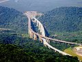
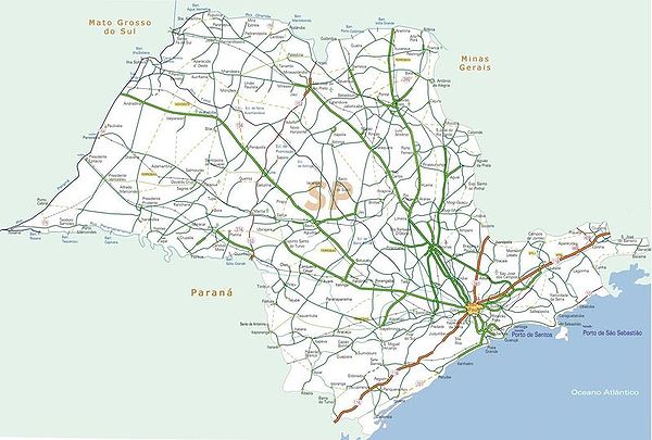
is the largest statewide road transportation system in Brazil
Brazil
Brazil , officially the Federative Republic of Brazil , is the largest country in South America. It is the world's fifth largest country, both by geographical area and by population with over 192 million people...
, with 34,650 km. It consists of a hugely interconnected network of municipal (11,600 km), state (22,000 km) and federal (1,050 km) roads. More than 90% of the population is within 5 km of a paved road.
It has also the largest number of two-, four- and six-lane highway
Highway
A highway is any public road. In American English, the term is common and almost always designates major roads. In British English, the term designates any road open to the public. Any interconnected set of highways can be variously referred to as a "highway system", a "highway network", or a...
s in Latin America
Latin America
Latin America is a region of the Americas where Romance languages – particularly Spanish and Portuguese, and variably French – are primarily spoken. Latin America has an area of approximately 21,069,500 km² , almost 3.9% of the Earth's surface or 14.1% of its land surface area...
. According to the National Confederation of Transports, it is the best highway grid in the country, with 59.4% classified as excellent.
The term used in Portuguese language
Portuguese language
Portuguese is a Romance language that arose in the medieval Kingdom of Galicia, nowadays Galicia and Northern Portugal. The southern part of the Kingdom of Galicia became independent as the County of Portugal in 1095...
for highway is rodovia, and for road is estrada.
Management systems
The responsibility for building, maintaining, expanding, managing and exploiting the state roads fall into the following categories:- DERSA Desenvolvimento Rodoviário S.A. A state-owned company, responsible for some state-built roads and highways, such as Rodovias Dom Pedro I, Carvalho Pinto, Ayrton Senna, etc. (see below for the names and specific information about highways);
- DER Departamento de Estradas de Rodagem. A state department belonging to the State Secretary of Transportation;
- Ministry of Transportation, responsible for the federal highways and roads crossing the state, such as Rodovias Presidente Dutra, Régis Bittencourt, Fernão Dias, etc.;
- Municipalities, responsible for vicinal roads and roads within counties.
- State concessions to private companies.

Privatization
Privatization is the incidence or process of transferring ownership of a business, enterprise, agency or public service from the public sector to the private sector or to private non-profit organizations...
and public concession of highway infrastructure management and economic exploitation (Programa Estadual de Desestatização - State Program of Desestatization), whereby most of the highways under the tutelage and built by the state began to be managed by private companies. In order to implement the Program, the highway grid was subdivided into 12 sections, with a total of 3,500 km, interconnecting 198 counties with a population of approximately 20 million inhabitants (54% of the state's population).
The following 12 companies were contracted under a public bidding system:
- AutoBan
- Autovias
- Centrovias
- ColinasColinas-See also:*List of municipalities in Rio Grande do Sul...
- Ecovias
- Intervias
- Renovias
- SPVias
- Tebe
- Triângulo do Sol
- Viaoeste
Until August 2005, these companies had invested R$ 6 billion (approximately US$ 2,5 billion) and generated a revenue of R$ 2 billion for the state. The concessions led also to the duplication (double laning) of more than 480 km and the construction of 110 new roads. All conceded highways are equipped with fixed emergency phones every 1 km, horizontal and vertical signalling equipment, surveillance cameras, and round-the-clock, free-of-charge mechanical and emergency relief vehicles. which make São Paulo highways the most sophisticated and with the highest safety and service standards of Latin America.
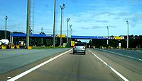
Toll road
A toll road is a privately or publicly built road for which a driver pays a toll for use. Structures for which tolls are charged include toll bridges and toll tunnels. Non-toll roads are financed using other sources of revenue, most typically fuel tax or general tax funds...
s, in order to pay for the services and investments. Roads managed by the state (DER) are generally not tolled. Toll collection is made in toll gates spaced along the road. Sometimes tolling occur only in one direction of the road, in other cases, in both directions. Toll pricing is set by the State Secretary of Transportation and vary from US$ 1 to US$ 4.
The entire São Paulo system of highways (16 in the total) use a unified non-stop electronic toll collection
Electronic toll collection
Electronic toll collection , an adaptation of military "identification friend or foe" technology, aims to eliminate the delay on toll roads by collecting tolls electronically. It is thus a technological implementation of a road pricing concept...
named "Sem Parar", based on RFID tags glued to the vehicle windshield, which comprises about 34% of the traffic through these roads. The system has 560,000 of these tags installed and generates 11 million of electronic transactions and revenues of ca. R$ 120 million (approximately US$ 52 million) per month.
Naming and numbering system
Within São Paulo, numbering of highways works as follows, starting with letters SP:- even numbers - indicates that the highway is radial, that is, connects the state capital to the interior. The number of the highway gives the clockwise angle that it makes with an imaginary line stemming from the state capital and extending northward. Thus SP-270 (Rodovia Raposo Tavares) starts in São Paulo and extends westward (thus a 270-degree clockwise angle with the imaginary north-extending line). Example: Rodovia Anhangüera, SP-330.
- odd numbers - indicates that the highway connects two or more places away from the capital. The number gives the distance, in km, between the capital and the nearest point of the highway. Thus, SP-425 (Rodovia Assis Chateubriand) connects two cities away from the capital, and its nearest point is distant 425 km from the state capital.
It is customary in Brazil, and particularly in São Paulo, to give also official names to the highways and roads, usually to pay homage to some politician, significant personality, national hero, etc., or to some symbolic or collective concept.
Infrastructure
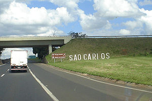
- SP-340: Rodovia Adhemar de BarrosRodovia Adhemar de BarrosRodovia Adhemar de Barros is a highway in the state of São Paulo, Brazil. It is 170 km long.The highway runs in an almost perfect South-North direction, departing from the city of Campinas, then passing by Jaguariúna, Holambra, Santo Antônio da Posse, Mogi Guaçu, Mogi Mirim, Estiva Gerbi,...
- SP-150: Rodovia AnchietaRodovia AnchietaRodovia Anchieta is a highway connection between São Paulo and the Atlantic coast, the cities of Cubatão and Santos, in Brazil...
- SP-330: Rodovia AnhangüeraRodovia AnhangüeraRodovia Anhangüera is a highway in the state of São Paulo, Brazil. It is one of the country's busiest transportation corridors...
- SP-322: Rodovia Attilio Balbo
- SP-070: Rodovia Ayrton SennaRodovia Ayrton SennaRodovia Ayrton Senna da Silva , is a highway in the state of São Paulo, Brazil....
- SP-348: Rodovia dos BandeirantesRodovia dos BandeirantesRodovia Bandeirantes is a highway in the state of São Paulo, Brazil.Once the traffic capacity of Anhangüera Highway was exceeded in the 1960s, the state government decided to built another highway, with a much higher capacity and modern design, directly connecting São Paulo City to Jundiaí,...
- SP 326: Rodovia Brigadeiro Faria LimaRodovia Brigadeiro Faria LimaRodovia Brigadeiro Faria Lima is a highway in the state of São Paulo, Brazil.SP-326 is a full four-lane highway connecting the cities of Bebedouro and Barretos, serving also the city of Colina, and runs in the Southeast to Northeast direction. It is managed and maintained through a state...
- SP-070: Rodovia Carvalho PintoRodovia Carvalho PintoRodovia Governador Carvalho Pinto is a highway in the state of São Paulo, Brazil.It is a continuation of the Rodovia Ayrton Senna , near the city of Guararema and ends by merging with Rodovia Presidente Dutra, which connects the cities of São Paulo and Rio de Janeiro; and Rodovia Floriano...
- SP-280: Rodovia Castelo BrancoRodovia Castelo BrancoRodovia Presidente Castelo Branco is a tollway in the state of São Paulo, Brazil. It was first opened on November 10, 1968, by, then, the Governor of the state of São Paulo, Abreu Sodré...
- SP-065: Rodovia Dom Pedro IRodovia Dom Pedro IRodovia Dom Pedro I is a highway in the state of São Paulo, Brazil.One of the best built and most scenic highways in the country, it interconnects the Anhangüera and the Presidente Dutra highways, serving the major cities of Campinas, Atibaia, Jacareí and São José dos Campos...
- SP-160: Rodovia dos ImigrantesRodovia dos ImigrantesRodovia dos Imigrantes is a highway in the state of São Paulo, Brazil.The highway connects the city of São Paulo to the Atlantic coast and with the seaside cities of São Vicente and Praia Grande. It follows the route of Rodovia Anchieta and is also one of Brazil's busiest highways, particularly on...
- SP-332: Rodovia Professor Zeferino Vaz
- SP-306: Rodovia Luiz de QueirozRodovia Luiz de QueirozRodovia Luiz de Queiroz is a highway in the state of São Paulo, Brazil.It interconnects the cities of Americana, by the Anhanguera Highway and Piracicaba, serving also the city of Santa Bárbara d'Oeste, at which level crosses with the Rodovia dos Bandeirantes...
- SP-300: Rodovia Marechal Cândido RondonRodovia Marechal Cândido RondonRodovia Marechal Cândido Rondon is a highway in the state of São Paulo, Brazil.It is one of the most recent highways of the state, and connects several cities, running in the North-Northwest direction, starting in Jundiai and serving the cities of Itu, Porto Feliz, Tietê, Laranjal Paulista,...
- SP-270: Rodovia Raposo TavaresRodovia Raposo TavaresRodovia Raposo Tavares is the longest highway in the state of São Paulo, Brazil, with 664 km.The highway starts in the city of São Paulo and continues westward, serving the main cities of Cotia, Vargem Grande Paulista, São Roque, Sorocaba, Itapetininga, Angatuba, Ourinhos, Assis, Presidente...
- SP-075: Rodovia Santos DumontRodovia Santos DumontRodovia Santos Dumont is a highway in the state of São Paulo, Brazil.It runs in a North-South direction and interconnects the cities of Campinas, Indaiatuba, Salto, Itu and Sorocaba, crossing with two other major highways, Rodovia Castelo Branco, nearby Sorocaba, and the Rodovia dos Bandeirantes...
- SP-310: Rodovia Washington LuísRodovia Washington LuísRodovia Washington Luís is a highway in the state of São Paulo, Brazil.It runs in the North-Northwest direction, departing as a branch from the Anhangüera Highway near the city of Limeira...
Other important double- or single-lane roads in the state are:
- SP-099: Rodovia dos TamoiosRodovia dos TamoiosRodovia dos Tamoios is a highway in the Brazilian state of São Paulo.The highway is partly dual-lane, part single-lane, and runs from the city of São José dos Campos, located in the Paraíba River valley in the upper plateau of São Paulo down the Serra do Mar to the coastal lowlands of the city of...
- SP-123: Rodovia Floriano Rodrigues PinheiroRodovia Floriano Rodrigues PinheiroRodovia Floriano Rodrigues Pinheiro is a single-lane highway in the state of São Paulo, Brazil. It connects the Rodovia Carvalho Pinto and the Rodovia Presidente Dutra nearby the city of Taubaté, to the mountain resort of Campos do Jordão.SP-123 is one of the most scenic roads in the state...
- SP-425: Rodovia Assis ChateaubriandRodovia Assis ChateaubriandRodovia Assis Chateubriand is a highway in the state of São Paulo, Brazil. Its name honours the Brazilian journalist and press tycoon, Assis Chateaubriand, owner of Diários Associados....
- SP-101: Rodovia Jornalista Francisco Aguirre ProençaRodovia Jornalista Francisco Aguirre ProençaRodovia Jornalista Francisco Aguirre Proença is a state highway in the State of São Paulo which connects the cities of Campinas, Hortolândia, Monte Mor, Elias Fausto and Capivari. Its first 25 kilometers are double-laned, the rest is still single-laned...
Three metropolitan beltways, or ring systems interconnect several highways, encircling the urban core of the cities of São Paulo, Campinas and Ribeirão Preto:
- Rodoanel Mário CovasRodoanel Mário CovasRodoanel Mário Covas is the planned Greater São Paulo Beltway, around the largest megalopolis of Brazil. Upon its completion, it will have a length of , with a radius of approximately from the geographical center of the city...
(SP-21): around the city of São Paulo, currently interconnects the Anhangüera, Bandeirantes, Castelo Branco, Raposo Tavares and Régis Bittencourt. Upon its completion, estimated for 2012, it will also interconnect the Imigrantes, Anchieta, Presidente Dutra, Fernão Dias and Ayrton Senna highways. - Anel Viário José Magalhães TeixeiraAnel Viário José Magalhães TeixeiraThe Anel Viário José Magalhães Teixeira is the Campinas Beltway, a ring of high-speed highways surrounding the city of Campinas, in the state of São Paulo, Brazil. The Campinas Beltway is the Northern vertex of the Macrometropolitan Highway System of Greater São Paulo and one of the few complete...
(SP-83): around the city of CampinasCampinasCampinas is a city and municipality located in the coastal interior of the state of São Paulo, Brazil. is the administrative center of the meso-region of the same name, with 3,783,597 inhabitants as of the 2010 Census, consisting of 49 cities....
, it currently interconnects the Anhangüera and Dom Pedro I highways, but there is an extension project to interconnect other highways, such as the Via Bandeirantes, which runs in parallel with Via Anhanguera. Since 2007, major works have increased the number of lanes in several points. - Anel Viário de Ribeirão Preto, around the city of Ribeirão PretoRibeirão PretoRibeirão Preto is a municipality and city in the Northeastern region of the state of São Paulo in Brazil. It is nicknamed Brazilian California, because of a combination of an economy based on agrobusiness plus high technology, wealth and sunny weather all year long. With 605,114 inhabitants,...
There are also five federal highways which partially cross the state territory, namely:
- Rodovia Presidente DutraRodovia Presidente DutraThe Rodovia Presidente Dutra, , colloquially known as Via Dutra is a federal highway which runs through the eastern part of the state of São Paulo and southwestern region of the state Rio de Janeiro...
, to Rio de JaneiroRio de JaneiroRio de Janeiro , commonly referred to simply as Rio, is the capital city of the State of Rio de Janeiro, the second largest city of Brazil, and the third largest metropolitan area and agglomeration in South America, boasting approximately 6.3 million people within the city proper, making it the 6th... - Rodovia Fernão DiasRodovia Fernão DiasThe Rodovia Fernão Dias is a federal highway which runs in the Brazilian states of São Paulo and southern region of Minas Gerais...
, to Belo HorizonteBelo HorizonteBelo Horizonte is the capital of and largest city in the state of Minas Gerais, located in the southeastern region of Brazil. It is the third largest metropolitan area in the country...
, state of Minas GeraisMinas GeraisMinas Gerais is one of the 26 states of Brazil, of which it is the second most populous, the third richest, and the fourth largest in area. Minas Gerais is the Brazilian state with the largest number of Presidents of Brazil, the current one, Dilma Rousseff, being one of them. The capital is the... - Rodovia Régis BittencourtRodovia Régis BittencourtRodovia Régis Bittencourt is a section of the BR-116 that connects the cities of São Paulo and Curitiba, Brazil. It is considered one of the most dangerous highways of Brazil, due to the high number of accidents. Sometimes it is even nicknamed "Rodovia da Morte" . It also leads the number of...
, to CuritibaCuritibaCuritiba is the capital of the Brazilian state of Paraná. It is the largest city with the biggest economy of both Paraná and southern Brazil. The population of Curitiba numbers approximately 1.75 million people and the latest GDP figures for the city surpass US$61 billion according to...
, state of ParanáParaná (state)Paraná is one of the states of Brazil, located in the South of the country, bordered on the north by São Paulo state, on the east by the Atlantic Ocean, on the south by Santa Catarina state and the Misiones Province of Argentina, and on the west by Mato Grosso do Sul and the republic of Paraguay,... - Rodovia Rio-Santos, between the cities of SantosSantos (São Paulo)-Sister cities: Shimonoseki, Japan Nagasaki, Japan Funchal, Portugal Trieste, Italy Coimbra, Portugal Ansião, Portugal Arouca, Portugal Ushuaia, Argentina Havana, Cuba Taizhou. China Ningbo. China Constanţa, Romania Ulsan, South Korea Colón, Panama* Cadiz, Spain...
and Rio de JaneiroRio de JaneiroRio de Janeiro , commonly referred to simply as Rio, is the capital city of the State of Rio de Janeiro, the second largest city of Brazil, and the third largest metropolitan area and agglomeration in South America, boasting approximately 6.3 million people within the city proper, making it the 6th... - Rodovia TransbrasilianaRodovia TransbrasilianaRodovia Transbrasiliana is a federal highway in Brazil .It crosses Brazil in the North-South direction, starting in Marabá, state of Pará and ending in Aceguá, in the state of Rio Grande do Sul...
(BR-153) crossing from the state of Minas GeraisMinas GeraisMinas Gerais is one of the 26 states of Brazil, of which it is the second most populous, the third richest, and the fourth largest in area. Minas Gerais is the Brazilian state with the largest number of Presidents of Brazil, the current one, Dilma Rousseff, being one of them. The capital is the...
to ParanáParaná (state)Paraná is one of the states of Brazil, located in the South of the country, bordered on the north by São Paulo state, on the east by the Atlantic Ocean, on the south by Santa Catarina state and the Misiones Province of Argentina, and on the west by Mato Grosso do Sul and the republic of Paraguay,...
External links
- Secretary of Transportation of the State Government of São Paulo
- DERSA Desenvolvimento Rodoviário SA, a state company for the development and maintenance of São Paulo's highways.
- DER - Highways State Department
- Transportation Agency of São Paulo - List of Highway Concessionaires
- Real time video cameras in São Paulo highways managed by DERSA.
- Private concessionaires of São Paulo highways