
.gif)
Black Mountains (North Carolina)
Encyclopedia
The Black Mountains are a mountain range in western North Carolina
, in the southeastern United States. They are part of the Blue Ridge Province
of the Southern Appalachian Mountains
. The Blacks are the highest mountains in the Eastern United States. The range takes its name from the dark appearance of the Red Spruce
and Fraser Fir
trees on the upper slopes which contrasts with the brown (during winter) or lighter green (during the growing season) appearance of the deciduous trees at lower elevations. The Eastern Continental Divide
, which runs along the eastern Blue Ridge crest, intersects the southern tip of the Black Mountain range.
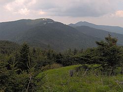
The Black Mountains are home to Mount Mitchell State Park
, which protects the range's highest summit and adjacent summits in the north-central section of the range. Much of the range is also protected by the Pisgah National Forest
. The Blue Ridge Parkway
passes along the range's southern section, and is connected to the summit of Mount Mitchell by North Carolina Highway 128. The Black Mountains are mostly located in Yancey County
, although the range's southern and western extremes are part of Buncombe County
.
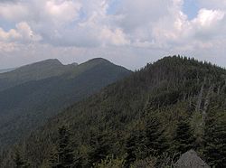 The Black Mountains form a J-shaped semicircle that opens to the northwest. The Blacks rise southward from the Little Crabtree Creek Valley in the north to the steep 6327 feet (1,928.5 m) summit of Celo Knob. A few miles south of Celo, the crest drops to 5700 feet (1,737.4 m) at Deep Gap before rising steeply again to the summit of Potato Hill in the north-central section of the range. The crest continues southward across the north-central section, which contains 6 of the 10 highest summits in the eastern United States, including the highest, Mount Mitchell, and the second-highest, Mount Craig. South of Mount Mitchell, the crest drops to just under 6000 feet (1,828.8 m) at Stepp's Gap before rising again to 6520 feet (1,987.3 m) at the summit of Mount Gibbes. On the slopes of Potato Knob, just south of Clingmans Peak, the Black Mountain crest bends northwestward across Blackstock Knob before dropping again to 5320 feet (1,621.5 m) at Balsam Gap, where it intersects the Great Craggy Mountains
to the southwest. The crest then turns northward across Point Misery and Big Butt before descending to the Cane River Valley.
The northern section of the Black Mountains are drained by the Cane River to the west and the South Toe River to the east, both of which are part of the upper Nolichucky River
watershed. The southwestern part of the range is drained by the upper French Broad River
which, like the Nolichucky, is west of the continental divide and thus its waters eventually wind up in the Gulf of Mexico
. A few of the streams in the southeastern section of the range are part of the Catawba River
watershed, and are thus east of the continental divide.
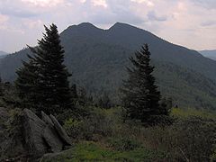
. The Black Mountains rise prominently above the surrounding lower terrain. This is particularly noticeable from the range's eastern side, which rises over 4500 feet (1375 meters) above the Catawba River Valley and Interstate 40
, providing some impressive mountain scenery.
 The Black Mountains consist primarily of Precambrian
gneiss
and schist
s formed over a billion years ago from primordial sea sediments. The mountains themselves were formed roughly 200-400 million years ago during the Alleghenian orogeny
, when the collision of two continental plates thrust what is now the Appalachian Mountains upward to form a large plateau. Weathering and minor geologic events in subsequent periods carved out the mountains.
During the last Ice Age
, approximately 20,000-16,000 years ago, glaciers did not advance into Southern Appalachia, but the change in temperatures drastically changed the forests in the region. A tree-less tundra
likely existed in the Black Mountains and surrounding mountains in elevations above 3500 feet (1,066.8 m). Spruce-fir forests dominated the lower elevations during this period, while hardwoods "fled" to warmer refuges in the coastal plains. As the ice sheets began retreating 16,000 years ago and temperatures started to rise, the hardwoods returned to the river valleys and lower slopes, and the spruce-fir forest retreated to the higher elevations. Today, the spruce-fir forest atop the Black Mountains is one of ten or so spruce-fir "islands" remaining in the mountains of Southern Appalachia.
(sometimes called the "boreal" or "Canadian" forest) is dominated by red spruce and Fraser fir, and coats the elevations above 5500 feet (1,676.4 m). The northern hardwoods, which consist primarily of beech
, yellow birch
, and buckeye
, thrive between 4500 feet (1,371.6 m) and 5500 feet (1,676.4 m). The more diverse Appalachian hardwoods, which include yellow poplar and various species of hickory
, oak
, and maple
, dominate the slopes and stream valleys below 3000 feet (914.4 m). Pine forests, consisting chiefly of Table Mountain Pine
, pitch pine
, and Virginia pine
, are found on the drier south-facing slopes. Mountain Paper birch
, which is rare in North Carolina, grows sporadically on the slopes of Mount Mitchell.
Wildlife in the Black Mountains is typical of the Appalachian highlands. Mammals include black bear
s, white-tailed deer
, raccoon
s, river otters, mink
s, bobcat
s, and the endangered northern flying squirrel
. Bird species include the wild turkey
, the Northern Saw-whet Owl
, and the pileated woodpecker
, although peregrine falcon
s and various species of hawk
are known to nest in the upper elevations. Brook trout
, which are more typical of northern latitudes, are found in the streams at the base of the Black Mountains.
 Native Americans
have likely been hunting in the Black Mountains for thousands of years. At Swannanoa Gap, just south of the range, archaeologists have uncovered evidence of habitation dating to the Archaic period (8000-1000 B.C.), the Woodland period
(1000 B.C. - 1000 A.D.), and the Mississippian period
(c. 900-1600 A.D.). The Mississippian-period village of Joara
was located near the town of Morganton
to the southeast.
The Hernando de Soto
expedition, which was attempting to travel from the Florida
coast to the Pacific Ocean, is believed to have passed through the North Toe River valley in May 1540, and thus would have included the first Europeans to see the Black Mountains. An expedition led by Juan Pardo
probably crossed the Blue Ridge at Swannanoa Gap in October 1567. Both expeditions spent considerable time at Joara.
, tobacco, liquor, and excess crops at markets in nearby Asheville. The early farmers also brought large herds of cattle and hogs, which thrived in the valleys and mountain areas.
In 1789, French botanist André Michaux
, who had been sent to America by the King of France to collect exotic plant specimens, made his first excursion into the Southern Appalachian Mountains, which included a brief trip to the Blacks. Michaux returned to the Blacks in August 1794, and collected several plant specimens that thrive above 4000 feet (1,219.2 m). Michaux's findings, published in the early 19th century, were among the first to bring attention to the diversity and significance of the plants of Southern Appalachia.
 In the early 19th century, Mount Washington
in New Hampshire
was believed to be the highest summit in the Eastern United States, an assumption many North Carolinians began to question in light of Michaux's findings (Michaux believed that Grandfather Mountain
was the highest). In 1835, the state dispatched North Carolina professor Elisha Mitchell
(1793–1857) into the western part of the state to measure the elevation of Grandfather, the Roan Highlands, and the Black Mountains. Using a crude barometer
, Mitchell gained measurements for Grandfather and Roan with apparent ease, although he struggled to discern which of the Blacks was the highest. After measuring Celo Knob, Mitchell descended to the Cane River Valley to obtain advice from the valley's residents. Two local guides (one of whom was William Wilson, a cousin of the later renowned mountain guide, Thomas "Big Tom" Wilson) led Mitchell up a bear trail to what they believed to be the highest summit. Although exactly which mountain they summited has long been disputed, it was likely Mount Gibbes, Clingmans Peak, or Mount Mitchell. Nevertheless, Mitchell obtained a measurement of 6476 feet (1,973.9 m) (later determined to be too low), placing the Blacks at a higher elevation than Mount Washington and thus the highest in the Eastern United States.
Mitchell returned to the Blacks in 1838 and 1844, gaining a higher measurement on each trip. Several surveyors visited the Blacks in subsequent years, including Nehemiah Blackstock (1794–1880) in 1845, Arnold Guyot (1807–1884) in 1849, and Robert Gibbes in the early 1850s. As early as Mitchell's third trip (1844) to the Blacks, the locals were calling what is now Clingmans Peak 35.735°N 82.286°W "Mount Mitchell", as they believed this was the summit measured by Mitchell as the highest. In 1855, Thomas Lanier Clingman
(1812–1897), a politician and former student of Mitchell's, climbed a summit north of Stepps Gap known as Black Dome (what is now Mount Mitchell) and measured its elevation at 6941 feet (2,115.6 m). Clingman reported his findings to Joseph Henry, the head of the Smithsonian Institution
. Henry, using Guyot's more careful and accurate measurements taken several years earlier, agreed with Clingman that Black Dome was higher (although Guyot noted Clingman's measurement of 6,941 feet was off by 200 feet), and the highest mountain in the Appalachians was to be named for Clingman.
When Mitchell learned of Clingman's find, he claimed that the mountain he had measured in 1844 was in fact Black Dome, and that locals had mistakenly named the summit to the south (the modern Clingmans Peak) after him. Clingman rejected Mitchell's claim, arguing that the route Mitchell took led south of Stepps Gap (i.e., to what is now Mount Gibbes or Clingmans Peak), and that a broken barometer found by Blackstock on Mount Gibbes in 1845 could only have been Mitchell's. The two bickered back and forth in the local newspapers throughout 1856, each claiming to have been the first to summit and measure the higher Black Dome. The debate was intensified by the political climate of the 1850s, as Mitchell was a Whig supporter and Clingman had recently left the Whig party to join the pro-secession Democrats. Zebulon Vance, a Whig politician and friend of Mitchell's, located the two guides Mitchell had recruited for his 1844 excursion, and when the two described the route they had followed, it appeared that Mitchell had indeed summited Mount Gibbes. Finally, in 1857, Mitchell returned to the Blacks in an attempt to gain still more accurate measurements. One evening, while attempting to reach the Cane River Valley, he slipped and fell into a gorge along Sugar Camp Fork, near the waterfall that now bears his name. His body was found 11 days later by the legendary mountain guide Thomas "Big Tom" Wilson (1825–1909).
Mitchell's death sparked an outpouring of public sympathy across North Carolina. Zebulon Vance led a movement to verify Mitchell as the first to summit the highest mountain in the Eastern United States, and to have the mountain named for him. Vance convinced several mountain guides to change previous statements and claim the route they had taken actually led to Black Dome, rather than Mount Gibbes. Mitchell was buried atop Black Dome on land donated by former governor David Lowry Swain
. Clingman continued to deny that Mitchell had measured Black Dome first, but was unable to overcome the shift in public sentiment. By 1858, Black Dome had been renamed "Mitchell's High Peak." In subsequent decades, Mount Mitchell was renamed "Clingmans Peak", and Mitchell's High Peak was renamed "Mount Mitchell." Clingman eventually turned to the Great Smoky Mountains
to the west, which he claimed were higher. Guyot's measurements in the Smokies rejected Clingman's assertions, although Guyot did manage to have the highest mountain in that range, known as Smoky Dome, renamed Clingmans Dome
.
(1861–1865) brought a temporary halt to the tourism boom, but by the late 1870s, the industry had recovered. In the 1880s, brothers K.M. and David Murchison established a large game preserve in the Cane River Valley which was managed by Tom Wilson.
As forests in the north were cut down to meet the growing demand for lumber in the late 19th century, logging firms turned to the virgin forests of Southern Appalachia. Between 1908 and 1912, northern lumber firms, namely Dickey and Campbell (later Perley and Crockett), Brown Brothers, Carolina Spruce, and Champion Fibre, bought up timber rights to most of the Black Mountains and began a series of massive logging operations in the area. In 1911, Dickey and Campbell managed to construct a narrow-gauge railroad line connecting the Swannanoa Valley with Clingmans Peak. Other narrow-gauge lines quickly followed. Between 1909 and 1915, much of the forest on the upper slopes and crest was cut down. An increase in demand for red spruce during World War I led to the rapid deforestation of much of the spruce-fir forest in the higher elevations. As forests were removed, forest fires (caused by the ignition of dried brush and slash left by loggers) and erosion denuded what was left of the landscape.
 Many North Carolinians, among them Governor Locke Craig and state forester John Simcox Holmes, were alarmed at the abusive logging practices that were stripping bare the Black Mountains. After the North Carolina state legislature rejected an initial attempt to create a state park at the summit of Mount Mitchell in 1913, Craig began negotiating with (and may have threatened) Perley and Crockett to preserve the forest atop Mitchell while he and Holmes lobbied for the creation of a state park. The state legislature finally approved the purchase of a stretch of land between Stepps Gap and the summit of what is now Big Tom in 1915, which became the core of Mount Mitchell State Park. The Pisgah National Forest, established in 1916, also began buying up and replanting lands that had been logged over.
In 1922, the Mount Mitchell Development Company (which had been formed by Fred Perley, a partner in Perley and Crockett) completed the first automobile road to Mount Mitchell, connecting the summit with the Swannanoa Valley. Adolphus and Ewart Wilson (the son and grandson of "Big Tom" Wilson) completed a road connecting the Cane River Valley with the summit of Mitchell shortly thereafter. The state eventually condemned the Wilsons' road, but allowed Ewart Wilson to operate an inn at Stepps Gap until the early 1960s. NC-128, which connects Mount Mitchell with the Blue Ridge Parkway, was completed in 1948.
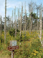 The Black Mountains, like many other ranges in the Appalachians, are currently threatened by acid rain
and air pollution
. Much of the range's once-famous Red Spruce and Fraser Fir trees are dead or dying due in part to the pollution. A more significant threat to the Firs, however, is the Balsam Woolly Adelgid
, an insect which may have an easier time killing the Firs than it normally would due to them being weakened by the acid rain. In some recent studies, individual Fraser fir trees which are resistant to the Adelgid have been found, lending hope to the possibility that these will again repopulate a healthy, mature Fir forest at the mountains' highest elevations.
At lower elevations of the Black Mountains, Eastern and Carolina Hemlock trees grow on moist slopes near streams (a National Forest recreation area on the Toe River at the base of Mount Mitchell is called "Carolina Hemlocks" for this reason). These too are under attack by an introduced pest, the Hemlock woolly adelgid
. Arriving only in the last few growing seasons, the health of the Hemlocks in the region is rapidly declining. Research is currently underway in releasing predator beetles that will, hopefully, eat enough Adelgids to balance their population and allow the Hemlocks to flourish.
The area around the Black Mountains is also experiencing rapid population growth as retirees from other states pour into the region. Due to a lack of zoning laws, this has resulted in rapid development of ridgetop cabins, large second-homes on the lower ridges, and deforestation
that threatens the natural beauty of the region. And although many people visit the Black Mountains for their legendary scenic views, visibility has been greatly reduced due to particulate matter in the air, mainly coming from large TVA coal-fired powerplaints "upstream" of the Black Mountains in the Midwest.
North Carolina
North Carolina is a state located in the southeastern United States. The state borders South Carolina and Georgia to the south, Tennessee to the west and Virginia to the north. North Carolina contains 100 counties. Its capital is Raleigh, and its largest city is Charlotte...
, in the southeastern United States. They are part of the Blue Ridge Province
Blue Ridge Mountains
The Blue Ridge Mountains are a physiographic province of the larger Appalachian Mountains range. This province consists of northern and southern physiographic regions, which divide near the Roanoke River gap. The mountain range is located in the eastern United States, starting at its southern-most...
of the Southern Appalachian Mountains
Appalachian Mountains
The Appalachian Mountains #Whether the stressed vowel is or ,#Whether the "ch" is pronounced as a fricative or an affricate , and#Whether the final vowel is the monophthong or the diphthong .), often called the Appalachians, are a system of mountains in eastern North America. The Appalachians...
. The Blacks are the highest mountains in the Eastern United States. The range takes its name from the dark appearance of the Red Spruce
Red Spruce
Picea rubens is a species of spruce native to eastern North America, ranging from eastern Quebec to Nova Scotia, and from New England south in the Adirondack Mountains and Appalachians to western North Carolina.-Physical description:...
and Fraser Fir
Fraser Fir
Abies fraseri is a species of fir native to the mountains of the eastern United States. It is closely related to Abies balsamea , of which it has occasionally been treated as a subspecies or a variety Abies fraseri (Fraser fir) is a species of fir native to the mountains of the eastern United...
trees on the upper slopes which contrasts with the brown (during winter) or lighter green (during the growing season) appearance of the deciduous trees at lower elevations. The Eastern Continental Divide
Eastern Continental Divide
The Eastern Continental Divide, in conjunction with other continental divides of North America, demarcates two watersheds of the Atlantic Ocean: the Gulf of Mexico watershed and the Atlantic Seaboard watershed. Prior to 1760, the divide represented the boundary between British and French colonial...
, which runs along the eastern Blue Ridge crest, intersects the southern tip of the Black Mountain range.
The Black Mountains are home to Mount Mitchell State Park
Mount Mitchell State Park
Mount Mitchell State Park is a North Carolina state park in Yancey County, North Carolina in the United States. Established in 1915 by the state legislature, it became the first state park of North Carolina...
, which protects the range's highest summit and adjacent summits in the north-central section of the range. Much of the range is also protected by the Pisgah National Forest
Pisgah National Forest
Pisgah National Forest is a National Forest in the Appalachian Mountains of western North Carolina. It is administered by the United States Forest Service, part of the United States Department of Agriculture. The Pisgah National Forest is completely contained within the state of North Carolina...
. The Blue Ridge Parkway
Blue Ridge Parkway
The Blue Ridge Parkway is a National Parkway and All-American Road in the United States, noted for its scenic beauty. It runs for 469 miles , mostly along the famous Blue Ridge, a major mountain chain that is part of the Appalachian Mountains...
passes along the range's southern section, and is connected to the summit of Mount Mitchell by North Carolina Highway 128. The Black Mountains are mostly located in Yancey County
Yancey County, North Carolina
-Demographics:As of the census of 2000, there were 17,774 people, 7,472 households, and 5,372 families residing in the county. The population density was 57 people per square mile . There were 9,729 housing units at an average density of 31 per square mile...
, although the range's southern and western extremes are part of Buncombe County
Buncombe County, North Carolina
-Demographics:As of the census of 2000, there were 206,330 people, 85,776 households, and 55,668 families residing in the county. The population density was 314 people per square mile . There were 93,973 housing units at an average density of 143 per square mile...
.
Geography
Great Craggy Mountains
The Great Craggy Mountains, commonly called the Craggies, are a mountain range in western North Carolina, United States. They are a subrange of the Blue Ridge Mountains and encompass an area of approx. 194 sq mi . They are situated in Buncombe County, North Carolina, 14 miles northeast of Asheville...
to the southwest. The crest then turns northward across Point Misery and Big Butt before descending to the Cane River Valley.
The northern section of the Black Mountains are drained by the Cane River to the west and the South Toe River to the east, both of which are part of the upper Nolichucky River
Nolichucky River
The Nolichucky River is a major stream draining the Blue Ridge Mountains of western North Carolina and east Tennessee. The river is long.-Hydrography:...
watershed. The southwestern part of the range is drained by the upper French Broad River
French Broad River
The French Broad River flows from near the village of Rosman in Transylvania County, North Carolina, into the state of Tennessee. Its confluence with the Holston River at Knoxville is the beginning of the Tennessee River....
which, like the Nolichucky, is west of the continental divide and thus its waters eventually wind up in the Gulf of Mexico
Gulf of Mexico
The Gulf of Mexico is a partially landlocked ocean basin largely surrounded by the North American continent and the island of Cuba. It is bounded on the northeast, north and northwest by the Gulf Coast of the United States, on the southwest and south by Mexico, and on the southeast by Cuba. In...
. A few of the streams in the southeastern section of the range are part of the Catawba River
Catawba River
The Catawba River is a tributary of the Wateree River in the U.S. states of North Carolina and South Carolina. The river is approximately 220 miles long...
watershed, and are thus east of the continental divide.
Notable summits
While the crest of the Black Mountain range is just 15 miles (24.1 km) long, within these fifteen miles are 18 peaks climbing to at least 6300 feet (1900 meters) above sea levelSea level
Mean sea level is a measure of the average height of the ocean's surface ; used as a standard in reckoning land elevation...
. The Black Mountains rise prominently above the surrounding lower terrain. This is particularly noticeable from the range's eastern side, which rises over 4500 feet (1375 meters) above the Catawba River Valley and Interstate 40
Interstate 40
Interstate 40 is the third-longest major east–west Interstate Highway in the United States, after I-90 and I-80. Its western end is at Interstate 15 in Barstow, California; its eastern end is at a concurrency of U.S. Route 117 and North Carolina Highway 132 in Wilmington, North Carolina...
, providing some impressive mountain scenery.
| Mountain | Elevation | General area | Coordinates | Named after |
|---|---|---|---|---|
| Mount Mitchell Mount Mitchell Mount Mitchell can refer to:* Mount Mitchell, the highest point in the eastern United States* Mount Mitchell , in Jasper National Park of Canada* Mount Mitchell * Mount Mitchell , in Queensland... |
6,684 ft/2,037 m | North-central Blacks | 35.76497, -82.265152 | Elisha Mitchell (1793–1857), professor and surveyor |
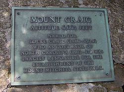
| Mount Craig Mount Craig (North Carolina) Mount Craig, , is the second highest peak of the Appalachian Mountains and second only to Mount Mitchell in eastern North America. It is located in the Black Mountains in Yancey County, North Carolina. The mountain lies just north of Mt... |
6,647 ft/2,026 m | North-central Blacks | 35.777584, -82.261759 | Locke Craig (1860–1925), North Carolina governor |
| Balsam Cone | 6,611 ft/2,015 m | North-central Blacks | 35.789705, -82.255846 | |
| Cattail Peak | 6,583 ft/2,006 m | North-central Blacks | 35.798413, -82.256502 | Possibly named for mountain lions that may have once frequented the summit |
| Big Tom | 6,581 ft/2,006 m | North-central Blacks | 35.779698, -82.259854 | Thomas "Big Tom" Wilson (1825–1909), legendary bear hunter and mountain guide |
| Mount Gibbes | 6,560 ft/1,999 m | Southern Blacks | 35.739124, -82.285235 | Robert Gibbes, surveyor |
| Clingmans Peak | 6,540 ft/1,993 m | Southern Blacks | 35.73504, -82.285986 | Thomas Lanier Clingman (1812–1897), politician and surveyor |
| Potato Hill | 6,475 ft/1,974 m | North-central Blacks | 35.801537, -82.25314 | |
| Potato Knob | 6,420 ft/1,957 m | Southern Blacks | 35.729955, -82.291246 | The mountain's shape, resembling an upright potato |
| Celo Knob Celo Knob Celo Knob is the northern most major peak in the Black Mountains of western North Carolina. It is located just north of Mount Mitchell State Park in the Pisgah National Forest.... |
6,327 ft/1,928 m | Northern Blacks | 35.852423, -82.248678 | The Cherokee Cherokee language Cherokee is an Iroquoian language spoken by the Cherokee people which uses a unique syllabary writing system. It is the only Southern Iroquoian language that remains spoken. Cherokee is a polysynthetic language.-North American etymology:... word selu, meaning "corn". |
| Mount Hallback | 6,320 ft/1,926 m | North-central Blacks | 35.748951, -82.275613 | |
| Blackstock Knob | 6,320 ft/1,926 m | Southern Blacks | 35.738063, -82.318615 | Nehemiah Blackstock (1794–1880), surveyor |
| Gibbs Mountain | 6,224 ft/1,897 m | Northern Blacks | 35.840947, -82.247985 | Methodist circuit rider Circuit rider (Religious) Circuit rider is a popular term referring to clergy in the earliest years of the United States who were assigned to travel around specific geographic territories to minister to settlers and organize congregations... who frequented the area in the early 19th century |
| Winter Star Mountain | 6,212 ft/1,893 m | Northern Blacks | 35.817668, -82.249273 | |
| Yeates Knob | 5,920 ft/1,804 m | Western Blacks | 35.786803, -82.346561 | |
| The Pinnacle | 5,665 ft/1,727 m | Southern Blacks | 35.704308, -82.275411 |
Geology
Precambrian
The Precambrian is the name which describes the large span of time in Earth's history before the current Phanerozoic Eon, and is a Supereon divided into several eons of the geologic time scale...
gneiss
Gneiss
Gneiss is a common and widely distributed type of rock formed by high-grade regional metamorphic processes from pre-existing formations that were originally either igneous or sedimentary rocks.-Etymology:...
and schist
Schist
The schists constitute a group of medium-grade metamorphic rocks, chiefly notable for the preponderance of lamellar minerals such as micas, chlorite, talc, hornblende, graphite, and others. Quartz often occurs in drawn-out grains to such an extent that a particular form called quartz schist is...
s formed over a billion years ago from primordial sea sediments. The mountains themselves were formed roughly 200-400 million years ago during the Alleghenian orogeny
Alleghenian orogeny
The Alleghenian orogeny or Appalachian orogeny is one of the geological mountain-forming events that formed the Appalachian Mountains and Allegheny Mountains. The term and spelling Alleghany orogeny was originally proposed by H.P. Woodward in 1957....
, when the collision of two continental plates thrust what is now the Appalachian Mountains upward to form a large plateau. Weathering and minor geologic events in subsequent periods carved out the mountains.
During the last Ice Age
Ice age
An ice age or, more precisely, glacial age, is a generic geological period of long-term reduction in the temperature of the Earth's surface and atmosphere, resulting in the presence or expansion of continental ice sheets, polar ice sheets and alpine glaciers...
, approximately 20,000-16,000 years ago, glaciers did not advance into Southern Appalachia, but the change in temperatures drastically changed the forests in the region. A tree-less tundra
Tundra
In physical geography, tundra is a biome where the tree growth is hindered by low temperatures and short growing seasons. The term tundra comes through Russian тундра from the Kildin Sami word tūndâr "uplands," "treeless mountain tract." There are three types of tundra: Arctic tundra, alpine...
likely existed in the Black Mountains and surrounding mountains in elevations above 3500 feet (1,066.8 m). Spruce-fir forests dominated the lower elevations during this period, while hardwoods "fled" to warmer refuges in the coastal plains. As the ice sheets began retreating 16,000 years ago and temperatures started to rise, the hardwoods returned to the river valleys and lower slopes, and the spruce-fir forest retreated to the higher elevations. Today, the spruce-fir forest atop the Black Mountains is one of ten or so spruce-fir "islands" remaining in the mountains of Southern Appalachia.
Plants and wildlife
The forests of the Black Mountains are typically divided into three zones based on altitude: the spruce-fir forest, the northern hardwoods, and the Appalachian hardwoods. The Southern Appalachian spruce-fir forestSouthern Appalachian spruce-fir forest
The Southern Appalachian spruce-fir forest is a type of montane coniferous forest that grows in the highest elevations in the southern Appalachian Mountains of the eastern United States...
(sometimes called the "boreal" or "Canadian" forest) is dominated by red spruce and Fraser fir, and coats the elevations above 5500 feet (1,676.4 m). The northern hardwoods, which consist primarily of beech
Beech
Beech is a genus of ten species of deciduous trees in the family Fagaceae, native to temperate Europe, Asia and North America.-Habit:...
, yellow birch
Yellow Birch
Betula alleghaniensis , is a species of birch native to eastern North America, from Newfoundland to Nova Scotia, New Brunswick, southern Quebec and Ontario, and the southeast corner of Manitoba in Canada, west to Minnesota, and south in the Appalachian Mountains to northern Georgia.It is a...
, and buckeye
Aesculus
The genus Aesculus comprises 13-19 species of woody trees and shrubs native to the temperate northern hemisphere, with 6 species native to North America and 7-13 species native to Eurasia; there are also several hybrids. Species are deciduous or evergreen...
, thrive between 4500 feet (1,371.6 m) and 5500 feet (1,676.4 m). The more diverse Appalachian hardwoods, which include yellow poplar and various species of hickory
Hickory
Trees in the genus Carya are commonly known as hickory, derived from the Powhatan language of Virginia. The genus includes 17–19 species of deciduous trees with pinnately compound leaves and big nuts...
, oak
Oak
An oak is a tree or shrub in the genus Quercus , of which about 600 species exist. "Oak" may also appear in the names of species in related genera, notably Lithocarpus...
, and maple
Maple
Acer is a genus of trees or shrubs commonly known as maple.Maples are variously classified in a family of their own, the Aceraceae, or together with the Hippocastanaceae included in the family Sapindaceae. Modern classifications, including the Angiosperm Phylogeny Group system, favour inclusion in...
, dominate the slopes and stream valleys below 3000 feet (914.4 m). Pine forests, consisting chiefly of Table Mountain Pine
Table Mountain Pine
Pinus pungens, the Table Mountain Pine, is a small pine native to the Appalachian Mountains in the United States. Table Mountain Pine, Pinus pungens, is also called Hickory Pine or Mountain Pine, though the latter name usually refers to the European species Mountain Pine - Pinus...
, pitch pine
Pitch Pine
The Pitch Pine, Pinus rigida, is a small-to-medium sized pine, native to eastern North America. This species occasionally hybridizes with other pine species such as Loblolly Pine , Shortleaf Pine , and Pond Pine The Pitch Pine, Pinus rigida, is a small-to-medium sized (6-30 meters or 20-100 feet)...
, and Virginia pine
Virginia Pine
Pinus virginiana is a medium-sized tree, often found on poorer soils from Long Island in southern New York south through the Appalachian Mountains to western Tennessee and Alabama. The usual size range for this pine is 9–18 m, but can grow taller under optimum conditions. The trunk can be...
, are found on the drier south-facing slopes. Mountain Paper birch
Betula cordifolia
Betula cordifolia is a birch species native to Eastern Canada and the North Eastern United States. Until recently it was considered a variety of Betula papyrifera , with which it shares many characteristics, and it was classified as B...
, which is rare in North Carolina, grows sporadically on the slopes of Mount Mitchell.
Wildlife in the Black Mountains is typical of the Appalachian highlands. Mammals include black bear
American black bear
The American black bear is a medium-sized bear native to North America. It is the continent's smallest and most common bear species. Black bears are omnivores, with their diets varying greatly depending on season and location. They typically live in largely forested areas, but do leave forests in...
s, white-tailed deer
White-tailed Deer
The white-tailed deer , also known as the Virginia deer or simply as the whitetail, is a medium-sized deer native to the United States , Canada, Mexico, Central America, and South America as far south as Peru...
, raccoon
Raccoon
Procyon is a genus of nocturnal mammals, comprising three species commonly known as raccoons, in the family Procyonidae. The most familiar species, the common raccoon , is often known simply as "the" raccoon, as the two other raccoon species in the genus are native only to the tropics and are...
s, river otters, mink
Mink
There are two living species referred to as "mink": the European Mink and the American Mink. The extinct Sea Mink is related to the American Mink, but was much larger. All three species are dark-colored, semi-aquatic, carnivorous mammals of the family Mustelidae, which also includes the weasels and...
s, bobcat
Bobcat
The bobcat is a North American mammal of the cat family Felidae, appearing during the Irvingtonian stage of around 1.8 million years ago . With twelve recognized subspecies, it ranges from southern Canada to northern Mexico, including most of the continental United States...
s, and the endangered northern flying squirrel
Northern Flying Squirrel
The Northern flying squirrel is one of two species of the genus Glaucomys, the only flying squirrels found in North America . Unlike most members of their family, flying squirrels are strictly nocturnal...
. Bird species include the wild turkey
Wild Turkey
The Wild Turkey is native to North America and is the heaviest member of the Galliformes. It is the same species as the domestic turkey, which derives from the South Mexican subspecies of wild turkey .Adult wild turkeys have long reddish-yellow to grayish-green...
, the Northern Saw-whet Owl
Northern Saw-whet Owl
The Northern Saw-whet Owl is a small owl native to North America.-Description:The scientific description of one of the sub-species of this owl is attributed to the Rev. John Henry Keen who was a missionary in Canada in 1896. Adults are long with a wingspan. They can weigh from with an average...
, and the pileated woodpecker
Pileated Woodpecker
The Pileated Woodpecker is a very large North American woodpecker, almost crow-sized, inhabiting deciduous forests in eastern North America, the Great Lakes, the boreal forests of Canada, and parts of the Pacific coast. It is also the largest woodpecker in America.Adults are long, and weigh...
, although peregrine falcon
Peregrine Falcon
The Peregrine Falcon , also known as the Peregrine, and historically as the Duck Hawk in North America, is a widespread bird of prey in the family Falconidae. A large, crow-sized falcon, it has a blue-gray back, barred white underparts, and a black head and "moustache"...
s and various species of hawk
Hawk
The term hawk can be used in several ways:* In strict usage in Australia and Africa, to mean any of the species in the subfamily Accipitrinae, which comprises the genera Accipiter, Micronisus, Melierax, Urotriorchis and Megatriorchis. The large and widespread Accipiter genus includes goshawks,...
are known to nest in the upper elevations. Brook trout
Brook trout
The brook trout, Salvelinus fontinalis, is a species of fish in the salmon family of order Salmoniformes. In many parts of its range, it is known as the speckled trout or squaretail. A potamodromous population in Lake Superior are known as coaster trout or, simply, as coasters...
, which are more typical of northern latitudes, are found in the streams at the base of the Black Mountains.
Prehistory
Native Americans in the United States
Native Americans in the United States are the indigenous peoples in North America within the boundaries of the present-day continental United States, parts of Alaska, and the island state of Hawaii. They are composed of numerous, distinct tribes, states, and ethnic groups, many of which survive as...
have likely been hunting in the Black Mountains for thousands of years. At Swannanoa Gap, just south of the range, archaeologists have uncovered evidence of habitation dating to the Archaic period (8000-1000 B.C.), the Woodland period
Woodland period
The Woodland period of North American pre-Columbian cultures was from roughly 1000 BCE to 1000 CE in the eastern part of North America. The term "Woodland Period" was introduced in the 1930s as a generic header for prehistoric sites falling between the Archaic hunter-gatherers and the...
(1000 B.C. - 1000 A.D.), and the Mississippian period
Mississippian culture
The Mississippian culture was a mound-building Native American culture that flourished in what is now the Midwestern, Eastern, and Southeastern United States from approximately 800 CE to 1500 CE, varying regionally....
(c. 900-1600 A.D.). The Mississippian-period village of Joara
Joara
Joara was a large Native American settlement, a regional chiefdom of the Mississippian culture, located in what is now Burke County, North Carolina. Joara is notable as a significant archaeological and historic site. It was a place of encounter in 1540 between the Mississippian people and the...
was located near the town of Morganton
Morganton, North Carolina
Morganton is a city in Burke County, North Carolina, United States. Reader's Digest included Morganton in its list of top ten places to raise a family. The town was recently profiled in The 50 Best Small Southern Towns. The population was 17,310 at the 2000 census...
to the southeast.
The Hernando de Soto
Hernando de Soto (explorer)
Hernando de Soto was a Spanish explorer and conquistador who, while leading the first European expedition deep into the territory of the modern-day United States, was the first European documented to have crossed the Mississippi River....
expedition, which was attempting to travel from the Florida
Florida
Florida is a state in the southeastern United States, located on the nation's Atlantic and Gulf coasts. It is bordered to the west by the Gulf of Mexico, to the north by Alabama and Georgia and to the east by the Atlantic Ocean. With a population of 18,801,310 as measured by the 2010 census, it...
coast to the Pacific Ocean, is believed to have passed through the North Toe River valley in May 1540, and thus would have included the first Europeans to see the Black Mountains. An expedition led by Juan Pardo
Juan Pardo (explorer)
Juan Pardo was a Spanish explorer and conquistador who was active in the later half of the sixteenth century. He led a Spanish expedition through what is now North and South Carolina and into eastern Tennessee. He established Fort San Felipe, South Carolina , and the village of Santa Elena on...
probably crossed the Blue Ridge at Swannanoa Gap in October 1567. Both expeditions spent considerable time at Joara.
Early settlement
For much of the 18th century, the Black Mountains were a hunting ground on the eastern fringe of Cherokee territory. By 1785, however, the Cherokee had signed away ownership of the Black Mountains to the United States, and Euro-American settlers moved into the Cane and South Toe valleys shortly thereafter. The early settlers farmed the river valleys and sold animal furs, ginsengGinseng
Ginseng is any one of eleven species of slow-growing perennial plants with fleshy roots, belonging to the genus Panax of the family Araliaceae....
, tobacco, liquor, and excess crops at markets in nearby Asheville. The early farmers also brought large herds of cattle and hogs, which thrived in the valleys and mountain areas.
In 1789, French botanist André Michaux
André Michaux
André Michaux was a French botanist and explorer.-Biography:Michaux was born in Satory, now part of Versailles, Yvelines. After the death of his wife within a year of their marriage he took up the study of botany and was a student of Bernard de Jussieu...
, who had been sent to America by the King of France to collect exotic plant specimens, made his first excursion into the Southern Appalachian Mountains, which included a brief trip to the Blacks. Michaux returned to the Blacks in August 1794, and collected several plant specimens that thrive above 4000 feet (1,219.2 m). Michaux's findings, published in the early 19th century, were among the first to bring attention to the diversity and significance of the plants of Southern Appalachia.
Elisha Mitchell and Thomas Lanier Clingman
Mount Washington (New Hampshire)
Mount Washington is the highest peak in the Northeastern United States at , famous for dangerously erratic weather. For 76 years, a weather observatory on the summit held the record for the highest wind gust directly measured at the Earth's surface, , on the afternoon of April 12, 1934...
in New Hampshire
New Hampshire
New Hampshire is a state in the New England region of the northeastern United States of America. The state was named after the southern English county of Hampshire. It is bordered by Massachusetts to the south, Vermont to the west, Maine and the Atlantic Ocean to the east, and the Canadian...
was believed to be the highest summit in the Eastern United States, an assumption many North Carolinians began to question in light of Michaux's findings (Michaux believed that Grandfather Mountain
Grandfather Mountain
Grandfather Mountain is a mountain, a non-profit attraction, and a North Carolina state parknear Linville, North Carolina. At 5,946 feet , it is the highest peak on the eastern escarpment of the Blue Ridge Mountains, one of the major chains of the Appalachian Mountains. The Blue Ridge Parkway...
was the highest). In 1835, the state dispatched North Carolina professor Elisha Mitchell
Elisha Mitchell
Elisha Mitchell was born in Washington, Connecticut. As a professor at the University of North Carolina at Chapel Hill, in 1835, he measured the height of Mt. Mitchell. Mt. Mitchell is the highest point east of the Mississippi River. It is located in North Carolina and is 6,684 feet high...
(1793–1857) into the western part of the state to measure the elevation of Grandfather, the Roan Highlands, and the Black Mountains. Using a crude barometer
Barometer
A barometer is a scientific instrument used in meteorology to measure atmospheric pressure. Pressure tendency can forecast short term changes in the weather...
, Mitchell gained measurements for Grandfather and Roan with apparent ease, although he struggled to discern which of the Blacks was the highest. After measuring Celo Knob, Mitchell descended to the Cane River Valley to obtain advice from the valley's residents. Two local guides (one of whom was William Wilson, a cousin of the later renowned mountain guide, Thomas "Big Tom" Wilson) led Mitchell up a bear trail to what they believed to be the highest summit. Although exactly which mountain they summited has long been disputed, it was likely Mount Gibbes, Clingmans Peak, or Mount Mitchell. Nevertheless, Mitchell obtained a measurement of 6476 feet (1,973.9 m) (later determined to be too low), placing the Blacks at a higher elevation than Mount Washington and thus the highest in the Eastern United States.
Mitchell returned to the Blacks in 1838 and 1844, gaining a higher measurement on each trip. Several surveyors visited the Blacks in subsequent years, including Nehemiah Blackstock (1794–1880) in 1845, Arnold Guyot (1807–1884) in 1849, and Robert Gibbes in the early 1850s. As early as Mitchell's third trip (1844) to the Blacks, the locals were calling what is now Clingmans Peak 35.735°N 82.286°W "Mount Mitchell", as they believed this was the summit measured by Mitchell as the highest. In 1855, Thomas Lanier Clingman
Thomas Lanier Clingman
Thomas Lanier Clingman , known as the "Prince of Politicians," was a Democratic member of the United States House of Representatives from 1843 to 1845 and from 1847 to 1858, and U.S. senator from the state of North Carolina between 1858 and 1861...
(1812–1897), a politician and former student of Mitchell's, climbed a summit north of Stepps Gap known as Black Dome (what is now Mount Mitchell) and measured its elevation at 6941 feet (2,115.6 m). Clingman reported his findings to Joseph Henry, the head of the Smithsonian Institution
Smithsonian Institution
The Smithsonian Institution is an educational and research institute and associated museum complex, administered and funded by the government of the United States and by funds from its endowment, contributions, and profits from its retail operations, concessions, licensing activities, and magazines...
. Henry, using Guyot's more careful and accurate measurements taken several years earlier, agreed with Clingman that Black Dome was higher (although Guyot noted Clingman's measurement of 6,941 feet was off by 200 feet), and the highest mountain in the Appalachians was to be named for Clingman.
When Mitchell learned of Clingman's find, he claimed that the mountain he had measured in 1844 was in fact Black Dome, and that locals had mistakenly named the summit to the south (the modern Clingmans Peak) after him. Clingman rejected Mitchell's claim, arguing that the route Mitchell took led south of Stepps Gap (i.e., to what is now Mount Gibbes or Clingmans Peak), and that a broken barometer found by Blackstock on Mount Gibbes in 1845 could only have been Mitchell's. The two bickered back and forth in the local newspapers throughout 1856, each claiming to have been the first to summit and measure the higher Black Dome. The debate was intensified by the political climate of the 1850s, as Mitchell was a Whig supporter and Clingman had recently left the Whig party to join the pro-secession Democrats. Zebulon Vance, a Whig politician and friend of Mitchell's, located the two guides Mitchell had recruited for his 1844 excursion, and when the two described the route they had followed, it appeared that Mitchell had indeed summited Mount Gibbes. Finally, in 1857, Mitchell returned to the Blacks in an attempt to gain still more accurate measurements. One evening, while attempting to reach the Cane River Valley, he slipped and fell into a gorge along Sugar Camp Fork, near the waterfall that now bears his name. His body was found 11 days later by the legendary mountain guide Thomas "Big Tom" Wilson (1825–1909).
Mitchell's death sparked an outpouring of public sympathy across North Carolina. Zebulon Vance led a movement to verify Mitchell as the first to summit the highest mountain in the Eastern United States, and to have the mountain named for him. Vance convinced several mountain guides to change previous statements and claim the route they had taken actually led to Black Dome, rather than Mount Gibbes. Mitchell was buried atop Black Dome on land donated by former governor David Lowry Swain
David Lowry Swain
David Lowry Swain was the 26th Governor of the U.S. state of North Carolina from 1832 to 1835.-Biography:Swain was born in Buncombe County, North Carolina; his father, George Swain, was a farmer and a member of the North Carolina General Assembly...
. Clingman continued to deny that Mitchell had measured Black Dome first, but was unable to overcome the shift in public sentiment. By 1858, Black Dome had been renamed "Mitchell's High Peak." In subsequent decades, Mount Mitchell was renamed "Clingmans Peak", and Mitchell's High Peak was renamed "Mount Mitchell." Clingman eventually turned to the Great Smoky Mountains
Great Smoky Mountains
The Great Smoky Mountains are a mountain range rising along the Tennessee–North Carolina border in the southeastern United States. They are a subrange of the Appalachian Mountains, and form part of the Blue Ridge Physiographic Province. The range is sometimes called the Smoky Mountains or the...
to the west, which he claimed were higher. Guyot's measurements in the Smokies rejected Clingman's assertions, although Guyot did manage to have the highest mountain in that range, known as Smoky Dome, renamed Clingmans Dome
Clingmans Dome
Clingmans Dome is a mountain in the Great Smoky Mountains of Tennessee and North Carolina, in the southeastern United States. At an elevation of , it is the highest mountain in the Smokies, the highest point in the state of Tennessee, and the highest point along the Appalachian Trail...
.
Tourism and logging
The revelation that the Black Mountains were the highest in the Appalachian Range made them an immediate tourist attraction. By the 1850s, a lodge had been established in the southern part of the range, and locals such as Jesse Stepp and Tom Wilson had built several rustic cabins on the higher mountain slopes and were thriving as mountain guides. The American Civil WarAmerican Civil War
The American Civil War was a civil war fought in the United States of America. In response to the election of Abraham Lincoln as President of the United States, 11 southern slave states declared their secession from the United States and formed the Confederate States of America ; the other 25...
(1861–1865) brought a temporary halt to the tourism boom, but by the late 1870s, the industry had recovered. In the 1880s, brothers K.M. and David Murchison established a large game preserve in the Cane River Valley which was managed by Tom Wilson.
As forests in the north were cut down to meet the growing demand for lumber in the late 19th century, logging firms turned to the virgin forests of Southern Appalachia. Between 1908 and 1912, northern lumber firms, namely Dickey and Campbell (later Perley and Crockett), Brown Brothers, Carolina Spruce, and Champion Fibre, bought up timber rights to most of the Black Mountains and began a series of massive logging operations in the area. In 1911, Dickey and Campbell managed to construct a narrow-gauge railroad line connecting the Swannanoa Valley with Clingmans Peak. Other narrow-gauge lines quickly followed. Between 1909 and 1915, much of the forest on the upper slopes and crest was cut down. An increase in demand for red spruce during World War I led to the rapid deforestation of much of the spruce-fir forest in the higher elevations. As forests were removed, forest fires (caused by the ignition of dried brush and slash left by loggers) and erosion denuded what was left of the landscape.
The conservation movement
In 1922, the Mount Mitchell Development Company (which had been formed by Fred Perley, a partner in Perley and Crockett) completed the first automobile road to Mount Mitchell, connecting the summit with the Swannanoa Valley. Adolphus and Ewart Wilson (the son and grandson of "Big Tom" Wilson) completed a road connecting the Cane River Valley with the summit of Mitchell shortly thereafter. The state eventually condemned the Wilsons' road, but allowed Ewart Wilson to operate an inn at Stepps Gap until the early 1960s. NC-128, which connects Mount Mitchell with the Blue Ridge Parkway, was completed in 1948.
Environmental threats
Acid rain
Acid rain is a rain or any other form of precipitation that is unusually acidic, meaning that it possesses elevated levels of hydrogen ions . It can have harmful effects on plants, aquatic animals, and infrastructure. Acid rain is caused by emissions of carbon dioxide, sulfur dioxide and nitrogen...
and air pollution
Air pollution
Air pollution is the introduction of chemicals, particulate matter, or biological materials that cause harm or discomfort to humans or other living organisms, or cause damage to the natural environment or built environment, into the atmosphere....
. Much of the range's once-famous Red Spruce and Fraser Fir trees are dead or dying due in part to the pollution. A more significant threat to the Firs, however, is the Balsam Woolly Adelgid
Balsam woolly adelgid
Balsam woolly adelgids are small wingless insects that infest and kill firs, especially Balsam Fir and Fraser Fir. They are an invasive species from Europe introduced to the United States around 1900....
, an insect which may have an easier time killing the Firs than it normally would due to them being weakened by the acid rain. In some recent studies, individual Fraser fir trees which are resistant to the Adelgid have been found, lending hope to the possibility that these will again repopulate a healthy, mature Fir forest at the mountains' highest elevations.
At lower elevations of the Black Mountains, Eastern and Carolina Hemlock trees grow on moist slopes near streams (a National Forest recreation area on the Toe River at the base of Mount Mitchell is called "Carolina Hemlocks" for this reason). These too are under attack by an introduced pest, the Hemlock woolly adelgid
Hemlock Woolly Adelgid
Hemlock woolly adelgid , commonly abbreviated as HWA, is a true bug native to East Asia that feeds by sucking sap from hemlock trees . In eastern North America, it is a destructive pest that poses a major threat to the eastern hemlock and the Carolina hemlock...
. Arriving only in the last few growing seasons, the health of the Hemlocks in the region is rapidly declining. Research is currently underway in releasing predator beetles that will, hopefully, eat enough Adelgids to balance their population and allow the Hemlocks to flourish.
The area around the Black Mountains is also experiencing rapid population growth as retirees from other states pour into the region. Due to a lack of zoning laws, this has resulted in rapid development of ridgetop cabins, large second-homes on the lower ridges, and deforestation
Deforestation
Deforestation is the removal of a forest or stand of trees where the land is thereafter converted to a nonforest use. Examples of deforestation include conversion of forestland to farms, ranches, or urban use....
that threatens the natural beauty of the region. And although many people visit the Black Mountains for their legendary scenic views, visibility has been greatly reduced due to particulate matter in the air, mainly coming from large TVA coal-fired powerplaints "upstream" of the Black Mountains in the Midwest.
Sources
- State Parks of North Carolina. Walter C. Biggs and James F. Parnell, Authors. John F. Blair, Publisher, 1989.
External links
- South Beyond 6000 in the Black Mountains — Site provided by the Carolina Mountain Club