

Joara
Encyclopedia
Joara was a large Native American
settlement, a regional chiefdom
of the Mississippian culture
, located in what is now Burke County
, North Carolina
. Joara is notable as a significant archaeological
and historic site. It was a place of encounter in 1540 between the Mississippian people and the party of Spanish conquistador
Hernando De Soto. A later expedition under Juan Pardo
in 1567 created the first brief European settlement in the interior of the continent.
settlement at Jamestown
and nearly 20 years before their "Lost Colony" at Roanoke Island
.
Located northwest of Morganton
, the site has been excavated in portions by the Upper Catawba Valley Archaeology Project. They hold regular open houses and educational events for the public during the summer excavation season.
Established about AD 1000, Joara was thriving when the Spanish
soldiers arrived in January 1567 under Captain Juan Pardo. They established a base there for the winter and called the settlement Cuenca. They built Fort San Juan. After 18 months, the natives killed the soldiers at the fort and burned the structures down. That same year they killed all but one of the 120 men Pardo had stationed at a total of six forts in the southeast interior, and destroyed all the forts. As a result, the Spanish ended their colonizing effort in the southeastern interior.
Effects of European infectious disease
s and conquest, and assimilation by larger native tribes, led to native abandonment of the settlement long before English explorers arrived in the region in the 17th century, followed by Scots-Irish and German immigrants in the 18th century.
Mound Builder culture, which was centered in the Mississippi
and Ohio
river valleys. By the time of the first European
contact with Native Americans in the foothills of the southern Appalachians, Joara had already grown to be the largest Mississippian-culture settlement in present-day North Carolina. The town served as the political center of a chiefdom that controlled many of the surrounding native settlements.
T.H. Lewis at first associated the term Xualla with the modern Qualla Boundary
(Cherokee); however, most scholars, following Swanton, connect the various spellings of Joara with Cheraw
, a Siouan-speaking people. This would mean the Catawba Nation
are likely descendants of the natives at Joara.
Both Cofitachequi
and the neighboring Coosa chiefdom
s were ancestral Muskogean-speaking groups apparently claiming other areas as tributary. The Creek were their descendants. The scholar Charles Hudson leaves open the possibility that Joara is a Cherokee name.
, South Carolina
and North Carolina. This expedition recorded the first European contact with the people of Joara, which de Soto's chroniclers called Xuala. De Soto brought the queen of Cofitachequi
province to Joara as an involuntary member of his entourage. The chroniclers also state that the queen claimed political dominion at this time over Joara province as well as the province of "Chalaque"
, and that the natives in both places respected her office. She managed to escape after reaching Joara.
The Spanish departed to continue their exploration of Spanish Florida
's interior, crossing westward over the Blue Ridge into eastern Tennessee, where they visited the Coosa chiefdom
at Guasile. It would be another 26 years before the Spanish would return, under the Juan Pardo Expedition, to try to enforce their claim over the land and its native inhabitants.
and 125 men departed from Santa Elena
, a center of Spanish Florida
(located on present-day Parris Island
, Beaufort County
, South Carolina) under orders from Governor Pedro Menéndez de Avilés
to claim the interior for Spain
. Pardo was to pacify the native inhabitants, convert them to Catholicism
, and establish a route to Spanish silver mines near Zacatecas
, Mexico
. The Spanish thought they were much closer to the mines than they were in fact.
To stay close to food sources on their journey through the foothills, the Spanish traveled northwest where there were friendly natives who would help to feed them. The small Spanish force stopped at Otari
(near present day Charlotte
, Mecklenburg County
, North Carolina) and Yssa (near present day Denver
, Lincoln County
, North Carolina) before arriving at Joara.
Captain Pardo and his men arrived at Joara in January 1567. He renamed it Cuenca after his hometown Cuenca, Spain
. Snow in the Appalachian Mountains forced the Spanish to establish a winter base in the foothills at Joara. The explorers built a wooden fort at the north end of Joara and named it Fort San Juan. The fort became the first European settlement of present-day North Carolina, predating the establishment of the first English colony at Roanoke Island
by 18 years and Jamestown by 40 years.
The Spanish kept a base in Fort San Juan and claimed sovereignty over several other settlements in the region, including Guaquiri (near present-day Hickory
, Catawba County, North Carolina) and Quinahaqui (in present-day Catawba County, North Carolina). In February 1567, Captain Pardo established Fort Santiago at Guatari, a smaller town of Guatari (also called Wateree
) natives located in present-day Rowan County
, North Carolina.
When Captain Pardo received word of a possible French invasion of Santa Elena (an early Spanish mission on the coast) he left 30 soldiers to occupy Joara, and four soldiers and his chaplain Father Sebastian Montero to occupy Guatari. He departed the area with the remainder of his force. Pardo appointed sergeant Hernando Moyano to command the force stationed at Fort San Juan.
, Virginia
) before returning to Joara.
After resting and supplying his force, Moyano led his force to Guapere (thought to be on the upper Watauga River
in present day Tennessee). The Spanish and native force attacked and burned Guapere and marched west to Chiaha
(also in present day Tennessee). Moyano's force built a fort in Chiaha and waited for Captain Juan Pardo to return.
Pardo first took his troops to the native village of Tocae (near present day Asheville, North Carolina
), then continued to Cauchi (near present day Canton, North Carolina
. The force continued on to Tanasqui and then to Chiaha where they found Hernando Moyano's troops in need of supply. After resupplying Moyano's troops, Pardo returned to Santa Elena.
and Cherokee
caused many of these smaller native groups to disappear.
In 1670, explorer John Lederer
, departing from Fort Henry
, explored deep into North Carolina and described a large town he called "Sara", in the mountains that "receive from the Spaniards the name of Suala". He states that the natives here mined cinnabar
to make purple facepaint, and had cakes of salt. James Needham and Gabriel Archer also explored the entire area from Fort Henry in 1671, and described this town as "Sarrah". However, this was likely several miles to the east of the original Joara.
By the time most English
, Moravian, Scots-Irish
, and German settlers arrived in the area in the 18th century, Joara and many of the other native towns in the region had been abandoned.
Although the location of Joara and Fort San Juan were forgotten, local inhabitants found numerous native artifacts in certain areas of the upper Catawba River Valley. Unlike areas in which mounds were protected, during the early 1950s farmers bulldozed Joara's twelve-foot-high earthen platform mound to make way for cultivation. The location of the mound is now recognizable only as a two-foot rise in the field but current owners vow to protect the site.
In 1986, a breakthrough occurred at the Berry excavation site (named for the family who own the property). Archaeologists discovered 16th-century Spanish artifacts. This evidence, supported by Bandera's 16th century narrative, caused a reevaluation of Pardo's route through the Upper Catawba Valley. Further evidence suggests the Berry Site is the location of Joara and Fort San Juan. The archaeological site has demonstrated the extent to which the Spanish attempted to establish a colonial foothold in the interior of the Southeast.
Further excavations at the Berry site throughout the 1990s and 2000s have yielded remains of native Joara settlement and burned Spanish huts, and more 16th-century Spanish artifacts, including olive jar fragments, a spike, and a knife. In 2007, the team excavated Structure 5 and found a Spanish iron scale, as well as evidence of Spanish building techniques. These artifacts were not trade goods but objects used by the Spanish in settlements. Joara is particularly interesting for the interaction between Native Americans and Spanish, who were relatively few in number and depended on the natives for food. Archaeologists expect to find evidence that will reveal more about events there.
Archaeologists familiar with the area have concluded this is the site of Joara and Fort San Juan. It supports documented Spanish settlement of 1567–1568, as well as the natives' burning of the fort. The discovery is requiring a reassessment of the history of European contact with Native Americans.
Native Americans in the United States
Native Americans in the United States are the indigenous peoples in North America within the boundaries of the present-day continental United States, parts of Alaska, and the island state of Hawaii. They are composed of numerous, distinct tribes, states, and ethnic groups, many of which survive as...
settlement, a regional chiefdom
Chiefdom
A chiefdom is a political economy that organizes regional populations through a hierarchy of the chief.In anthropological theory, one model of human social development rooted in ideas of cultural evolution describes a chiefdom as a form of social organization more complex than a tribe or a band...
of the Mississippian culture
Mississippian culture
The Mississippian culture was a mound-building Native American culture that flourished in what is now the Midwestern, Eastern, and Southeastern United States from approximately 800 CE to 1500 CE, varying regionally....
, located in what is now Burke County
Burke County, North Carolina
-Demographics:As of the census of 2000, there were 89,148 people, 34,528 households, and 24,342 families residing in the county. The population density was 176 people per square mile . There were 37,427 housing units at an average density of 74 per square mile...
, North Carolina
North Carolina
North Carolina is a state located in the southeastern United States. The state borders South Carolina and Georgia to the south, Tennessee to the west and Virginia to the north. North Carolina contains 100 counties. Its capital is Raleigh, and its largest city is Charlotte...
. Joara is notable as a significant archaeological
Archaeology
Archaeology, or archeology , is the study of human society, primarily through the recovery and analysis of the material culture and environmental data that they have left behind, which includes artifacts, architecture, biofacts and cultural landscapes...
and historic site. It was a place of encounter in 1540 between the Mississippian people and the party of Spanish conquistador
Conquistador
Conquistadors were Spanish soldiers, explorers, and adventurers who brought much of the Americas under the control of Spain in the 15th to 16th centuries, following Europe's discovery of the New World by Christopher Columbus in 1492...
Hernando De Soto. A later expedition under Juan Pardo
Juan Pardo (explorer)
Juan Pardo was a Spanish explorer and conquistador who was active in the later half of the sixteenth century. He led a Spanish expedition through what is now North and South Carolina and into eastern Tennessee. He established Fort San Felipe, South Carolina , and the village of Santa Elena on...
in 1567 created the first brief European settlement in the interior of the continent.
History
Recent archaeological finds have established evidence of both substantial Mississippian and sustained Spanish 16th-century settlement in the interior of North Carolina. Joara was the site of Fort San Juan, established by the Juan Pardo expedition as the earliest Spanish outpost (1567–1568) in the interior of what is now North Carolina. This was 40 years before the EnglishEngland
England is a country that is part of the United Kingdom. It shares land borders with Scotland to the north and Wales to the west; the Irish Sea is to the north west, the Celtic Sea to the south west, with the North Sea to the east and the English Channel to the south separating it from continental...
settlement at Jamestown
Jamestown Settlement
Jamestown Settlement is a name used by the Commonwealth of Virginia's portion of the historical sites and museums at Jamestown. Jamestown was the first successful English settlement on the mainland of North America...
and nearly 20 years before their "Lost Colony" at Roanoke Island
Roanoke Island
Roanoke Island is an island in Dare County near the coast of North Carolina, United States. It was named after the historical Roanoke Carolina Algonquian people who inhabited the area in the 16th century at the time of English exploration....
.
Located northwest of Morganton
Morganton, North Carolina
Morganton is a city in Burke County, North Carolina, United States. Reader's Digest included Morganton in its list of top ten places to raise a family. The town was recently profiled in The 50 Best Small Southern Towns. The population was 17,310 at the 2000 census...
, the site has been excavated in portions by the Upper Catawba Valley Archaeology Project. They hold regular open houses and educational events for the public during the summer excavation season.
Established about AD 1000, Joara was thriving when the Spanish
Spanish colonization of the Americas
Colonial expansion under the Spanish Empire was initiated by the Spanish conquistadores and developed by the Monarchy of Spain through its administrators and missionaries. The motivations for colonial expansion were trade and the spread of the Christian faith through indigenous conversions...
soldiers arrived in January 1567 under Captain Juan Pardo. They established a base there for the winter and called the settlement Cuenca. They built Fort San Juan. After 18 months, the natives killed the soldiers at the fort and burned the structures down. That same year they killed all but one of the 120 men Pardo had stationed at a total of six forts in the southeast interior, and destroyed all the forts. As a result, the Spanish ended their colonizing effort in the southeastern interior.
Effects of European infectious disease
Infectious disease
Infectious diseases, also known as communicable diseases, contagious diseases or transmissible diseases comprise clinically evident illness resulting from the infection, presence and growth of pathogenic biological agents in an individual host organism...
s and conquest, and assimilation by larger native tribes, led to native abandonment of the settlement long before English explorers arrived in the region in the 17th century, followed by Scots-Irish and German immigrants in the 18th century.
Settlement
Joara is thought to have been settled some time after AD 1000. It was established on the west bank of Upper Creek and within sight of Table Rock, a dominant geographical feature of the area. The Joara natives comprised the eastern extent of MississippianMississippian culture
The Mississippian culture was a mound-building Native American culture that flourished in what is now the Midwestern, Eastern, and Southeastern United States from approximately 800 CE to 1500 CE, varying regionally....
Mound Builder culture, which was centered in the Mississippi
Mississippi
Mississippi is a U.S. state located in the Southern United States. Jackson is the state capital and largest city. The name of the state derives from the Mississippi River, which flows along its western boundary, whose name comes from the Ojibwe word misi-ziibi...
and Ohio
Ohio
Ohio is a Midwestern state in the United States. The 34th largest state by area in the U.S.,it is the 7th‑most populous with over 11.5 million residents, containing several major American cities and seven metropolitan areas with populations of 500,000 or more.The state's capital is Columbus...
river valleys. By the time of the first European
European ethnic groups
The ethnic groups in Europe are the various ethnic groups that reside in the nations of Europe. European ethnology is the field of anthropology focusing on Europe....
contact with Native Americans in the foothills of the southern Appalachians, Joara had already grown to be the largest Mississippian-culture settlement in present-day North Carolina. The town served as the political center of a chiefdom that controlled many of the surrounding native settlements.
T.H. Lewis at first associated the term Xualla with the modern Qualla Boundary
Qualla Boundary
The Qualla Boundary is the territory where the Eastern Band of Cherokee Indians reside in western North Carolina.-Location:...
(Cherokee); however, most scholars, following Swanton, connect the various spellings of Joara with Cheraw
Cheraw
-Peoples:* Cheraw , a tribe of Siouan-speakng Amerindians who historically lived in Virginia and North Carolina, in the future southeastern United States...
, a Siouan-speaking people. This would mean the Catawba Nation
Catawba (tribe)
The Catawba are a federally recognized tribe of Native Americans, known as the Catawba Indian Nation. They live in the Southeast United States, along the border between North and South Carolina near the city of Rock Hill...
are likely descendants of the natives at Joara.
Both Cofitachequi
Cofitachequi
Cofitachequi was a paramount chiefdom encountered by the Hernando de Soto Expedition in South Carolina. They encountered the Chiefdom of Cofitachequi in April of 1540, at the Mulberry Site, a large mound at the junction of Pine Tree Creek and the Wateree River, near present-day Camden...
and the neighboring Coosa chiefdom
Coosa chiefdom
The Coosa chiefdom was a powerful Native American paramount chiefdom near what are now Gordon and Murray counties in Georgia, in the United States. It was inhabited from about 1400 until about 1600, and dominated several smaller chiefdoms...
s were ancestral Muskogean-speaking groups apparently claiming other areas as tributary. The Creek were their descendants. The scholar Charles Hudson leaves open the possibility that Joara is a Cherokee name.
Spanish exploration
Hernando de Soto
In 1540, Hernando de Soto led a Spanish army up the eastern edge of the Appalachian mountains through present-day GeorgiaGeorgia (U.S. state)
Georgia is a state located in the southeastern United States. It was established in 1732, the last of the original Thirteen Colonies. The state is named after King George II of Great Britain. Georgia was the fourth state to ratify the United States Constitution, on January 2, 1788...
, South Carolina
South Carolina
South Carolina is a state in the Deep South of the United States that borders Georgia to the south, North Carolina to the north, and the Atlantic Ocean to the east. Originally part of the Province of Carolina, the Province of South Carolina was one of the 13 colonies that declared independence...
and North Carolina. This expedition recorded the first European contact with the people of Joara, which de Soto's chroniclers called Xuala. De Soto brought the queen of Cofitachequi
Cofitachequi
Cofitachequi was a paramount chiefdom encountered by the Hernando de Soto Expedition in South Carolina. They encountered the Chiefdom of Cofitachequi in April of 1540, at the Mulberry Site, a large mound at the junction of Pine Tree Creek and the Wateree River, near present-day Camden...
province to Joara as an involuntary member of his entourage. The chroniclers also state that the queen claimed political dominion at this time over Joara province as well as the province of "Chalaque"
Cherokee
The Cherokee are a Native American people historically settled in the Southeastern United States . Linguistically, they are part of the Iroquoian language family...
, and that the natives in both places respected her office. She managed to escape after reaching Joara.
The Spanish departed to continue their exploration of Spanish Florida
Spanish Florida
Spanish Florida refers to the Spanish territory of Florida, which formed part of the Captaincy General of Cuba, the Viceroyalty of New Spain, and the Spanish Empire. Originally extending over what is now the southeastern United States, but with no defined boundaries, la Florida was a component of...
's interior, crossing westward over the Blue Ridge into eastern Tennessee, where they visited the Coosa chiefdom
Coosa chiefdom
The Coosa chiefdom was a powerful Native American paramount chiefdom near what are now Gordon and Murray counties in Georgia, in the United States. It was inhabited from about 1400 until about 1600, and dominated several smaller chiefdoms...
at Guasile. It would be another 26 years before the Spanish would return, under the Juan Pardo Expedition, to try to enforce their claim over the land and its native inhabitants.
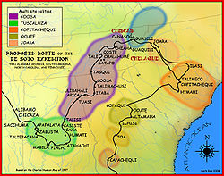
Captain Juan Pardo's first expedition
On December 1, 1566, Captain Juan PardoJuan Pardo (explorer)
Juan Pardo was a Spanish explorer and conquistador who was active in the later half of the sixteenth century. He led a Spanish expedition through what is now North and South Carolina and into eastern Tennessee. He established Fort San Felipe, South Carolina , and the village of Santa Elena on...
and 125 men departed from Santa Elena
Santa Elena, la Florida
Santa Elena was a Spanish settlement founded by Pedro Menéndez de Avilés on what is now Parris Island, South Carolina. There had been a number of earlier attempts to establish colonies in the area by both the Spanish and the French, who had been inspired by earlier accounts of the plentiful land...
, a center of Spanish Florida
Spanish Florida
Spanish Florida refers to the Spanish territory of Florida, which formed part of the Captaincy General of Cuba, the Viceroyalty of New Spain, and the Spanish Empire. Originally extending over what is now the southeastern United States, but with no defined boundaries, la Florida was a component of...
(located on present-day Parris Island
Parris Island, South Carolina
Parris Island is a former census-designated place , currently a portion of Port Royal in Beaufort County, South Carolina, United States. The population was 4,841 at the 2000 census. As defined by the U.S. Census Bureau, Parris Island is included within the Beaufort Urban Cluster and the larger...
, Beaufort County
Beaufort County, South Carolina
-National protected areas:*Ernest F. Hollings ACE Basin National Wildlife Refuge *Pinckney Island National Wildlife Refuge-Demographics:As of the census of 2000, there were 155,215 people, 45,532 households, and 33,056 families residing in the county. The population density was 206 people per...
, South Carolina) under orders from Governor Pedro Menéndez de Avilés
Pedro Menéndez de Avilés
Pedro Menéndez de Avilés was a Spanish admiral and explorer, best remembered for founding St. Augustine, Florida in 1565. This was the first successful Spanish foothold in La Florida and remained the most significant city in the region for several hundred years. St...
to claim the interior for Spain
Spain
Spain , officially the Kingdom of Spain languages]] under the European Charter for Regional or Minority Languages. In each of these, Spain's official name is as follows:;;;;;;), is a country and member state of the European Union located in southwestern Europe on the Iberian Peninsula...
. Pardo was to pacify the native inhabitants, convert them to Catholicism
Catholicism
Catholicism is a broad term for the body of the Catholic faith, its theologies and doctrines, its liturgical, ethical, spiritual, and behavioral characteristics, as well as a religious people as a whole....
, and establish a route to Spanish silver mines near Zacatecas
Zacatecas
Zacatecas officially Estado Libre y Soberano de Zacatecas is one of the 31 states which, with the Federal District, comprise the 32 Federal Entities of Mexico. It is divided in 58 municipalities and its capital city is Zacatecas....
, Mexico
Mexico
The United Mexican States , commonly known as Mexico , is a federal constitutional republic in North America. It is bordered on the north by the United States; on the south and west by the Pacific Ocean; on the southeast by Guatemala, Belize, and the Caribbean Sea; and on the east by the Gulf of...
. The Spanish thought they were much closer to the mines than they were in fact.
To stay close to food sources on their journey through the foothills, the Spanish traveled northwest where there were friendly natives who would help to feed them. The small Spanish force stopped at Otari
Otari
Otari may refer to:* Otari, Nagano, Japan*Muhammad Naji al-Otari, Prime Minister of Syria...
(near present day Charlotte
Charlotte, North Carolina
Charlotte is the largest city in the U.S. state of North Carolina and the seat of Mecklenburg County. In 2010, Charlotte's population according to the US Census Bureau was 731,424, making it the 17th largest city in the United States based on population. The Charlotte metropolitan area had a 2009...
, Mecklenburg County
Mecklenburg County, North Carolina
-Air:The county's primary commercial aviation airport is Charlotte Douglas International Airport in Charlotte.- Intercity rail :With twenty-five freight trains a day, Mecklenburg is a freight railroad transportation center, largely due to its place on the NS main line between Washington and Atlanta...
, North Carolina) and Yssa (near present day Denver
Denver, North Carolina
Denver, formerly known as "Dry Pond," is an unincorporated community located in Lincoln County in the U.S. state of North Carolina. It is situated on North Carolina State Highway 16 on the west side of Lake Norman on the Catawba River...
, Lincoln County
Lincoln County, North Carolina
-Demographics:As of the census of 2010, there were 71,498 people, 24,041 households, and 18,174 families residing in the county. The population density was 214 people per square mile . There were 25,717 housing units at an average density of 86 per square mile...
, North Carolina) before arriving at Joara.
Captain Pardo and his men arrived at Joara in January 1567. He renamed it Cuenca after his hometown Cuenca, Spain
Cuenca, Spain
-History:When the Iberian peninsula was part of the Roman Empire there were several important settlements in the province, such as Segóbriga, Ercávica and Gran Valeria...
. Snow in the Appalachian Mountains forced the Spanish to establish a winter base in the foothills at Joara. The explorers built a wooden fort at the north end of Joara and named it Fort San Juan. The fort became the first European settlement of present-day North Carolina, predating the establishment of the first English colony at Roanoke Island
Roanoke Island
Roanoke Island is an island in Dare County near the coast of North Carolina, United States. It was named after the historical Roanoke Carolina Algonquian people who inhabited the area in the 16th century at the time of English exploration....
by 18 years and Jamestown by 40 years.
The Spanish kept a base in Fort San Juan and claimed sovereignty over several other settlements in the region, including Guaquiri (near present-day Hickory
Hickory, North Carolina
Hickory is a city in Catawba County, North Carolina. Hickory has the 162nd largest urban area in the United States. As of the 2000 census, the Metropolitan Statistical Area had a population of 341,851, making it the 4th largest metropolitan area in North Carolina. The city's population was 37,222...
, Catawba County, North Carolina) and Quinahaqui (in present-day Catawba County, North Carolina). In February 1567, Captain Pardo established Fort Santiago at Guatari, a smaller town of Guatari (also called Wateree
Wateree
The Wateree were one of the first groups of Native Americans in the interior of the East Coast to encounter Europeans. They were recorded in 1567, by Spanish captain Juan Pardo's scribe Bandera for his expeditions through the interior of the Carolinas. They were named the Guatari in Bandera's...
) natives located in present-day Rowan County
Rowan County, North Carolina
-Demographics and economics:As of the census of 2010, there were 138,428 people, 53,140 households, and 37,058 families residing in the county. The population density was 270.7 people per square mile . There were 60,211 housing units at an average density of 117.7 per square mile...
, North Carolina.
When Captain Pardo received word of a possible French invasion of Santa Elena (an early Spanish mission on the coast) he left 30 soldiers to occupy Joara, and four soldiers and his chaplain Father Sebastian Montero to occupy Guatari. He departed the area with the remainder of his force. Pardo appointed sergeant Hernando Moyano to command the force stationed at Fort San Juan.
Hernando Moyano's raids
During the spring of 1567, Hernando Moyano led a combined force of natives and Spanish north. The force attacked and burned the Chiska tribe's village of Maniateque (near present-day SaltvilleSaltville, Virginia
As of the census of 2000, there were 2,204 people, 909 households, and 660 families residing in the town. The population density was 273.7 people per square mile . There were 1,003 housing units at an average density of 124.5 per square mile...
, Virginia
Virginia
The Commonwealth of Virginia , is a U.S. state on the Atlantic Coast of the Southern United States. Virginia is nicknamed the "Old Dominion" and sometimes the "Mother of Presidents" after the eight U.S. presidents born there...
) before returning to Joara.
After resting and supplying his force, Moyano led his force to Guapere (thought to be on the upper Watauga River
Watauga River
The Watauga River is a large stream of western North Carolina and East Tennessee. It is 60 miles long with its headwaters on the slopes of Grandfather Mountain and Peak Mountain in Watauga County, North Carolina.-Hydrography:...
in present day Tennessee). The Spanish and native force attacked and burned Guapere and marched west to Chiaha
Chiaha
Chiaha was a horticultural Native American chiefdom located in the lower French Broad River valley in modern East Tennessee, in the southeastern United States. They lived in raised structures within boundaries of several stable villages. These overlooked the fields of maize, beans, squash, and...
(also in present day Tennessee). Moyano's force built a fort in Chiaha and waited for Captain Juan Pardo to return.
Captain Juan Pardo's second expedition
Captain Juan Pardo returned to Fort San Juan in September of 1567 to find the local inhabitants angered by the Spanish raids and demands for food, women, and canoes. The effect of newly introduced diseases was also destabilizing the community, causing resentment towards the Spanish. Instead of continuing his mission to Mexico, Captain Pardo left a garrison at Fort San Juan and marched the remainder of his troops westward to resupply Sgt. Hernando Moyano's troops.Pardo first took his troops to the native village of Tocae (near present day Asheville, North Carolina
Asheville, North Carolina
Asheville is a city in and the county seat of Buncombe County, North Carolina, United States. It is the largest city in Western North Carolina, and the 11th largest city in North Carolina. The City is home to the United States National Climatic Data Center , which is the world's largest active...
), then continued to Cauchi (near present day Canton, North Carolina
Canton, North Carolina
Canton is the second largest town in Haywood County, North Carolina, United States. It is located about west of Asheville, North Carolina and is part of the Asheville Metropolitan Statistical Area. The town is named after the city of Canton, Ohio.- History :...
. The force continued on to Tanasqui and then to Chiaha where they found Hernando Moyano's troops in need of supply. After resupplying Moyano's troops, Pardo returned to Santa Elena.
Native uprising and end of Spanish colonization
Shortly after May 1568, news reached Santa Elena that the native population had burned the six Spanish forts established by Juan Pardo and killed all but one of the 120 Spanish men stationed in those garrisons. Captain Pardo never returned to the area, and Spain ended all attempts to conquer and colonize the southeastern interior. Captain Juan Pardo's narrative of his travels and settlement at Joara, written by his scribe Bandera, were discovered and translated in the 1980s. They have contributed to a reassessment of the history of Spanish colonization in the interior of North America.Demise and abandonment
At the time of the first Spanish contact, the native people of the area were identified by their villages of residence and were not part of large tribes. Death from European diseases and conquest and assimilation by large tribes such as the CatawbaCatawba (tribe)
The Catawba are a federally recognized tribe of Native Americans, known as the Catawba Indian Nation. They live in the Southeast United States, along the border between North and South Carolina near the city of Rock Hill...
and Cherokee
Cherokee
The Cherokee are a Native American people historically settled in the Southeastern United States . Linguistically, they are part of the Iroquoian language family...
caused many of these smaller native groups to disappear.
In 1670, explorer John Lederer
John Lederer
John Lederer was a 17th-century German physician and an explorer of the Appalachian Mountains. He and the members of his party became the first Europeans to crest the Blue Ridge Mountains and the first to see the Shenandoah Valley and the Allegheny Mountains beyond...
, departing from Fort Henry
Fort Henry (Virginia)
Fort Henry was an English frontier fort in 17th century colonial Virginia near the falls of the Appomattox River. Its exact location has been debated, but the most popular one is on a bluff about four blocks north of the corner of W. Washington and N...
, explored deep into North Carolina and described a large town he called "Sara", in the mountains that "receive from the Spaniards the name of Suala". He states that the natives here mined cinnabar
Cinnabar
Cinnabar or cinnabarite , is the common ore of mercury.-Word origin:The name comes from κινναβαρι , a Greek word most likely applied by Theophrastus to several distinct substances...
to make purple facepaint, and had cakes of salt. James Needham and Gabriel Archer also explored the entire area from Fort Henry in 1671, and described this town as "Sarrah". However, this was likely several miles to the east of the original Joara.
By the time most English
England
England is a country that is part of the United Kingdom. It shares land borders with Scotland to the north and Wales to the west; the Irish Sea is to the north west, the Celtic Sea to the south west, with the North Sea to the east and the English Channel to the south separating it from continental...
, Moravian, Scots-Irish
Scots-Irish American
Scotch-Irish Americans are an estimated 250,000 Presbyterian and other Protestant dissenters from the Irish province of Ulster who immigrated to North America primarily during the colonial era and their descendants. Some scholars also include the 150,000 Ulster Protestants who immigrated to...
, and German settlers arrived in the area in the 18th century, Joara and many of the other native towns in the region had been abandoned.
Although the location of Joara and Fort San Juan were forgotten, local inhabitants found numerous native artifacts in certain areas of the upper Catawba River Valley. Unlike areas in which mounds were protected, during the early 1950s farmers bulldozed Joara's twelve-foot-high earthen platform mound to make way for cultivation. The location of the mound is now recognizable only as a two-foot rise in the field but current owners vow to protect the site.
Rediscovery at the Berry site
During the 1960s and 1970s, several archaeological surveys were conducted in Burke County to determine possible locations of Joara and Fort San Juan. By the 1980s, archaeologists had reduced the number of possible locations and began limited excavations. These surveys and excavations showed that the upper Catawba River Valley did have a sizable native population during the 14th to 16th centuries.In 1986, a breakthrough occurred at the Berry excavation site (named for the family who own the property). Archaeologists discovered 16th-century Spanish artifacts. This evidence, supported by Bandera's 16th century narrative, caused a reevaluation of Pardo's route through the Upper Catawba Valley. Further evidence suggests the Berry Site is the location of Joara and Fort San Juan. The archaeological site has demonstrated the extent to which the Spanish attempted to establish a colonial foothold in the interior of the Southeast.
Further excavations at the Berry site throughout the 1990s and 2000s have yielded remains of native Joara settlement and burned Spanish huts, and more 16th-century Spanish artifacts, including olive jar fragments, a spike, and a knife. In 2007, the team excavated Structure 5 and found a Spanish iron scale, as well as evidence of Spanish building techniques. These artifacts were not trade goods but objects used by the Spanish in settlements. Joara is particularly interesting for the interaction between Native Americans and Spanish, who were relatively few in number and depended on the natives for food. Archaeologists expect to find evidence that will reveal more about events there.
Archaeologists familiar with the area have concluded this is the site of Joara and Fort San Juan. It supports documented Spanish settlement of 1567–1568, as well as the natives' burning of the fort. The discovery is requiring a reassessment of the history of European contact with Native Americans.
See also
- List of sites and peoples visited by the Hernando de Soto Expedition
- Southeastern Ceremonial ComplexSoutheastern Ceremonial ComplexThe Southeastern Ceremonial Complex is the name given to the regional stylistic similarity of artifacts, iconography, ceremonies, and mythology of the Mississippian culture that coincided with their adoption of maize agriculture and chiefdom-level complex social organization from...
- Mississippian cultureMississippian cultureThe Mississippian culture was a mound-building Native American culture that flourished in what is now the Midwestern, Eastern, and Southeastern United States from approximately 800 CE to 1500 CE, varying regionally....
- List of Mississippian sites
- Bussell IslandBussell IslandBussell Island, formerly Lenoir Island, is an island located at the mouth of the Little Tennessee River near the U.S. city of Lenoir City, Tennessee. The island was inhabited by various Native American cultures for thousands of years before the arrival of early European explorers, and is currently...