
Clingmans Dome
Encyclopedia
Clingmans Dome is a mountain in the Great Smoky Mountains
of Tennessee
and North Carolina
, in the southeastern United States. At an elevation of 6643 feet (2,024.8 m), it is the highest mountain in the Smokies, the highest point in the state of Tennessee, and the highest point along the 2174 miles (3,498.7 km) Appalachian Trail
. East of the Mississippi River
, only Mount Mitchell
(6684 feet (2,037.3 m)) and Mount Craig
(6647 feet (2,026 m)) are higher.
Clingmans Dome is protected as part of the Great Smoky Mountains National Park
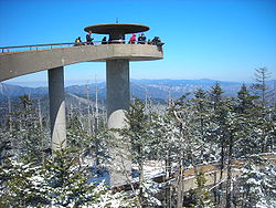
. A paved road, closed in winter (December 1 through March 31), connects it to U.S. Highway 441 (Newfound Gap
Road). The concrete observation tower, built in 1959, offers a panoramic view of the mountains in every direction. An air quality monitoring station, operated by the Environmental Protection Agency
, is the second highest in eastern North America
.
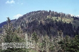
The Southern Appalachian spruce-fir forest
which covers Clingmans Dome occurs only at the highest elevations in the southeastern United States, and has more in common with forests at northern latitudes than with the forests in the adjacent valleys. Clingmans Dome stands prominently above the surrounding terrain, rising nearly 5000 feet (1,524 m) from base to summit.
 Reputedly known as "Kuwahi" (the mulberry
place) by the Cherokee
Indians, the mountain was dubbed "Smoky Dome" by American settlers moving in from other areas. In 1859, the mountain was renamed by Arnold Guyot for compatriot Thomas Lanier Clingman
(1812–1897), an American Civil War
general who explored the area extensively in the 1850s and then spent many years promoting it. Guyot named the mountain for Clingman because of an argument between Clingman and a professor at the University of North Carolina
, Elisha Mitchell
, over which mountain was actually the highest in the region. Mitchell contended that a peak by the name of Black Dome (now known as Mount Mitchell
) was the highest, while Clingman asserted that Smoky Dome was the true highest peak. Guyot determined that Black Dome was 39 feet (12 m) higher than Smoky Dome.
.
Clingmans Dome has two subpeaks: 6560 feet (1,999.5 m) Mount Buckley to the west and 6400 foot Mount Love to the east. The headwaters of several substantial streams are located on the slopes of Clingmans Dome, namely Little River
on the north slope, and Forney Creek and Noland Creek (both tributaries of the Tuckasegee River) on the south slope. The mountain is located entirely within the Tennessee River
watershed.
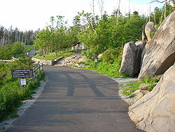 Clingmans Dome is the most accessible mountain top in the Great Smoky Mountains National Park. Closed from December 1 through March 31, the 7 miles (11.3 km) Clingmans Dome Road begins just past Newfound Gap and leads up the mountain to the Forney Ridge Parking Area, 300 feet (91.4 m) below the summit. A half-mile (0.5 mile (0.80467 km)) paved trail leads from the parking lot to the 54 feet (16.5 m) observation tower at the top of the mountain. The short, steep trail provides a small visitor information center and park store staffed by the Great Smoky Mountains Association, garbage cans, and numerous benches to the side of the path. Vault toilet restrooms are available. The trail offers a glimpse of the often hostile environment of highland Appalachia, passing through the spruce-fir forest and its accompanying blowdowns and dead Fraser Fir
s. The observation tower allows spectators a 360 degree panorama of the surrounding mountains, on the infrequent occasion of a clear, sunny day. Cantilevered signs, hanging from the rails of the tower, point out the various peaks, ridges, cities, and other features visible in the distance. Depending on the haze, visibility ranges from 20 miles (32.2 km) on hazy days to 100 miles (160.9 km) on very clear days.
The Appalachian Trail
crosses Clingmans Dome, passing immediately north of the observation tower. A 7.5 miles (12.1 km) leg of the trail connects the mountain with Newfound Gap, and provides the only non-overnight access to the mountain in winter months. The nearest A.T. backcountry shelters are the Double Spring Gap Shelter, which is 2.6 miles (4.2 km) to the west near the Goshen Prong junction, and the Mount Collins shelter, which is 4 miles (6.4 km) to the east near the A.T.'s Sugarland Mountain Trail
junction. Clingmans Dome is the base for several additional hiking trails, including the Forney Ridge Trail (to Andrews Bald
) and the Forney Creek Trail (to the Benton MacKaye Trail
on the shores of Fontana Lake
).
The western terminus of the Mountains-to-Sea Trail
, which connects the Smokies to the Outer Banks
of North Carolina, is located atop Clingmans Dome. It follows the Appalachian Trail for 3.8 miles (6.1 km) to the east, where it then begins to descend toward the Blue Ridge Parkway
, via the Fork Ridge Trail.
Great Smoky Mountains
The Great Smoky Mountains are a mountain range rising along the Tennessee–North Carolina border in the southeastern United States. They are a subrange of the Appalachian Mountains, and form part of the Blue Ridge Physiographic Province. The range is sometimes called the Smoky Mountains or the...
of Tennessee
Tennessee
Tennessee is a U.S. state located in the Southeastern United States. It has a population of 6,346,105, making it the nation's 17th-largest state by population, and covers , making it the 36th-largest by total land area...
and North Carolina
North Carolina
North Carolina is a state located in the southeastern United States. The state borders South Carolina and Georgia to the south, Tennessee to the west and Virginia to the north. North Carolina contains 100 counties. Its capital is Raleigh, and its largest city is Charlotte...
, in the southeastern United States. At an elevation of 6643 feet (2,024.8 m), it is the highest mountain in the Smokies, the highest point in the state of Tennessee, and the highest point along the 2174 miles (3,498.7 km) Appalachian Trail
Appalachian Trail
The Appalachian National Scenic Trail, generally known as the Appalachian Trail or simply the AT, is a marked hiking trail in the eastern United States extending between Springer Mountain in Georgia and Mount Katahdin in Maine. It is approximately long...
. East of the Mississippi River
Mississippi River
The Mississippi River is the largest river system in North America. Flowing entirely in the United States, this river rises in western Minnesota and meanders slowly southwards for to the Mississippi River Delta at the Gulf of Mexico. With its many tributaries, the Mississippi's watershed drains...
, only Mount Mitchell
Mount Mitchell
Mount Mitchell can refer to:* Mount Mitchell, the highest point in the eastern United States* Mount Mitchell , in Jasper National Park of Canada* Mount Mitchell * Mount Mitchell , in Queensland...
(6684 feet (2,037.3 m)) and Mount Craig
Mount Craig (North Carolina)
Mount Craig, , is the second highest peak of the Appalachian Mountains and second only to Mount Mitchell in eastern North America. It is located in the Black Mountains in Yancey County, North Carolina. The mountain lies just north of Mt...
(6647 feet (2,026 m)) are higher.
Clingmans Dome is protected as part of the Great Smoky Mountains National Park
Great Smoky Mountains National Park
Great Smoky Mountains National Park is a United States National Park and UNESCO World Heritage Site that straddles the ridgeline of the Great Smoky Mountains, part of the Blue Ridge Mountains, which are a division of the larger Appalachian Mountain chain. The border between Tennessee and North...
. A paved road, closed in winter (December 1 through March 31), connects it to U.S. Highway 441 (Newfound Gap
Newfound Gap
Newfound Gap is a mountain pass located near the center of the Great Smoky Mountains National Park of the southern Appalachian Mountains in the United States of America. Situated along the border of Tennessee and North Carolina, the state line crosses the gap, as does U.S...
Road). The concrete observation tower, built in 1959, offers a panoramic view of the mountains in every direction. An air quality monitoring station, operated by the Environmental Protection Agency
United States Environmental Protection Agency
The U.S. Environmental Protection Agency is an agency of the federal government of the United States charged with protecting human health and the environment, by writing and enforcing regulations based on laws passed by Congress...
, is the second highest in eastern North America
North America
North America is a continent wholly within the Northern Hemisphere and almost wholly within the Western Hemisphere. It is also considered a northern subcontinent of the Americas...
.
The Southern Appalachian spruce-fir forest
Southern Appalachian spruce-fir forest
The Southern Appalachian spruce-fir forest is a type of montane coniferous forest that grows in the highest elevations in the southern Appalachian Mountains of the eastern United States...
which covers Clingmans Dome occurs only at the highest elevations in the southeastern United States, and has more in common with forests at northern latitudes than with the forests in the adjacent valleys. Clingmans Dome stands prominently above the surrounding terrain, rising nearly 5000 feet (1,524 m) from base to summit.
History
Mulberry
Morus is a genus of flowering plants in the family Moraceae. The 10–16 species of deciduous trees it contains are commonly known as Mulberries....
place) by the Cherokee
Cherokee
The Cherokee are a Native American people historically settled in the Southeastern United States . Linguistically, they are part of the Iroquoian language family...
Indians, the mountain was dubbed "Smoky Dome" by American settlers moving in from other areas. In 1859, the mountain was renamed by Arnold Guyot for compatriot Thomas Lanier Clingman
Thomas Lanier Clingman
Thomas Lanier Clingman , known as the "Prince of Politicians," was a Democratic member of the United States House of Representatives from 1843 to 1845 and from 1847 to 1858, and U.S. senator from the state of North Carolina between 1858 and 1861...
(1812–1897), an American Civil War
American Civil War
The American Civil War was a civil war fought in the United States of America. In response to the election of Abraham Lincoln as President of the United States, 11 southern slave states declared their secession from the United States and formed the Confederate States of America ; the other 25...
general who explored the area extensively in the 1850s and then spent many years promoting it. Guyot named the mountain for Clingman because of an argument between Clingman and a professor at the University of North Carolina
University of North Carolina at Chapel Hill
The University of North Carolina at Chapel Hill is a public research university located in Chapel Hill, North Carolina, United States...
, Elisha Mitchell
Elisha Mitchell
Elisha Mitchell was born in Washington, Connecticut. As a professor at the University of North Carolina at Chapel Hill, in 1835, he measured the height of Mt. Mitchell. Mt. Mitchell is the highest point east of the Mississippi River. It is located in North Carolina and is 6,684 feet high...
, over which mountain was actually the highest in the region. Mitchell contended that a peak by the name of Black Dome (now known as Mount Mitchell
Mount Mitchell (North Carolina)
Mount Mitchell is the highest peak of the Appalachian Mountains and the highest peak in the eastern United States. It was the highest point in any state of the United States until Texas joined the union in 1845. The nearest higher point east of the Rocky Mountains is Harney Peak in the Black Hills...
) was the highest, while Clingman asserted that Smoky Dome was the true highest peak. Guyot determined that Black Dome was 39 feet (12 m) higher than Smoky Dome.
Geology
Clingmans Dome, like most of the Smokies, consists of a type of lightly metamorphosed sedimentary rock (especially sandstone) that is part of a formation known as the Ocoee Supergroup. These rocks were created from ancient ocean sediments nearly one billion years ago. Although a dense forest understory covers most of the mountain, this rock type is noticeable in rock outcroppings and in a large boulder pile at the Forney Ridge Parking Lot at the end of Clingmans Dome Road. The actual age of the mountains is somewhat speculative, but they are among the oldest in the world, created approximately 200-300 million years ago in the Alleghenian orogenyAlleghenian orogeny
The Alleghenian orogeny or Appalachian orogeny is one of the geological mountain-forming events that formed the Appalachian Mountains and Allegheny Mountains. The term and spelling Alleghany orogeny was originally proposed by H.P. Woodward in 1957....
.
Clingmans Dome has two subpeaks: 6560 feet (1,999.5 m) Mount Buckley to the west and 6400 foot Mount Love to the east. The headwaters of several substantial streams are located on the slopes of Clingmans Dome, namely Little River
Little River (Tennessee)
Little River is a scenic river in Tennessee which drains a area containing some of the most spectacular scenery in the southeastern United States. The first of the river are all located within the borders of the Great Smoky Mountains National Park...
on the north slope, and Forney Creek and Noland Creek (both tributaries of the Tuckasegee River) on the south slope. The mountain is located entirely within the Tennessee River
Tennessee River
The Tennessee River is the largest tributary of the Ohio River. It is approximately 652 miles long and is located in the southeastern United States in the Tennessee Valley. The river was once popularly known as the Cherokee River, among other names...
watershed.
Access
Fraser Fir
Abies fraseri is a species of fir native to the mountains of the eastern United States. It is closely related to Abies balsamea , of which it has occasionally been treated as a subspecies or a variety Abies fraseri (Fraser fir) is a species of fir native to the mountains of the eastern United...
s. The observation tower allows spectators a 360 degree panorama of the surrounding mountains, on the infrequent occasion of a clear, sunny day. Cantilevered signs, hanging from the rails of the tower, point out the various peaks, ridges, cities, and other features visible in the distance. Depending on the haze, visibility ranges from 20 miles (32.2 km) on hazy days to 100 miles (160.9 km) on very clear days.
The Appalachian Trail
Appalachian Trail
The Appalachian National Scenic Trail, generally known as the Appalachian Trail or simply the AT, is a marked hiking trail in the eastern United States extending between Springer Mountain in Georgia and Mount Katahdin in Maine. It is approximately long...
crosses Clingmans Dome, passing immediately north of the observation tower. A 7.5 miles (12.1 km) leg of the trail connects the mountain with Newfound Gap, and provides the only non-overnight access to the mountain in winter months. The nearest A.T. backcountry shelters are the Double Spring Gap Shelter, which is 2.6 miles (4.2 km) to the west near the Goshen Prong junction, and the Mount Collins shelter, which is 4 miles (6.4 km) to the east near the A.T.'s Sugarland Mountain Trail
Sugarland Mountain Trail
The Sugarland Mountain Trail is an American hiking trail, in the Great Smoky Mountains National Park of Sevier County, Tennessee. The trail traverses Sugarland Mountain, a massive ridge running perpendicular to the main crest of the Smokies and effectively dividing the park's north-central section...
junction. Clingmans Dome is the base for several additional hiking trails, including the Forney Ridge Trail (to Andrews Bald
Andrews Bald
Andrews Bald is a mountain in the Great Smoky Mountains, located in the Southeastern United States. It has an elevation of above sea level, making it the highest grassy bald in the Great Smoky Mountains National Park. The mountain is one of two grassy balds maintained in the range by the park...
) and the Forney Creek Trail (to the Benton MacKaye Trail
Benton MacKaye Trail
The Benton MacKaye Trail or BMT is a footpath nearly in length in the Appalachian Mountains in the southeastern United States and is blazed by a white diamond, 5" across by 7" tall...
on the shores of Fontana Lake
Fontana Lake
Fontana Lake is a reservoir impounded by Fontana Dam on the Little Tennessee River located in Graham and Swain counties in North Carolina. The lake forms part of the southern border of Great Smoky Mountains National Park and the northern border of part of the Nantahala National Forest. Depending on...
).
The western terminus of the Mountains-to-Sea Trail
Mountains-to-Sea Trail
The Mountains-to-Sea Trail is a long-distance trail, for hiking and backpacking, that runs across North Carolina from the Great Smoky Mountains to the Outer Banks. The trail's western endpoint is at Clingman's Dome, where it connects to the Appalachian Trail in the Great Smoky Mountains National...
, which connects the Smokies to the Outer Banks
Outer Banks
The Outer Banks is a 200-mile long string of narrow barrier islands off the coast of North Carolina, beginning in the southeastern corner of Virginia Beach on the east coast of the United States....
of North Carolina, is located atop Clingmans Dome. It follows the Appalachian Trail for 3.8 miles (6.1 km) to the east, where it then begins to descend toward the Blue Ridge Parkway
Blue Ridge Parkway
The Blue Ridge Parkway is a National Parkway and All-American Road in the United States, noted for its scenic beauty. It runs for 469 miles , mostly along the famous Blue Ridge, a major mountain chain that is part of the Appalachian Mountains...
, via the Fork Ridge Trail.