
Tlalnepantla de Baz
Encyclopedia
Tlalnepantla de Baz is a city and a municipality of the State of Mexico in the north of Mexico City
(Ciudad de Mexico). Tlalnepantla comes from the Náhuatl words tlalli (land) and nepantla (middle) to mean the middle land. The city was known in prior times as Tlalnepantla de Galeana and Tlalnepantla de Comonfort, to honor Hermenegildo Galeana
and Ignacio Comonfort
, respectively. The current addition of Baz comes from the last name of Gustavo Baz Prada, an important politician and soldier of Emiliano Zapata
's army during the Mexican Revolution
. After the Revolution, Baz Prada became Governor of the State of Mexico and President of the National Autonomous University of Mexico (UNAM). It is located in the northeastern part of the State of Mexico, in the Valley of Mexico north of Mexico City
proper.
is named), migrated to this area following their leader Xolotl
to look for a better climate and more food to sustain themselves. This same Xolotl founded the Tenayuca Oztopolco chiefdom and made the first census ever in the Americas. The Acolhua
s, Tepanecas and Otomi
s were already established in this land so alliances were made. Despite of this, the region eventually was conquered and made a tributary of the Aztec empire. After the Spanish Conquest, the area was evangelized by the Franciscans. The founding of modern Tlalnepantla was the result of a dispute between the towns of Tenayuca and Teocalhueyacan as to which should be the site of Franciscan monastery and religious center for the area. The result was to place the monastery at the midpoint between these two towns, and hence the name (middle land). This monastery, named Corpus Christi was built in 1550. After independence, Tlalnepantla was originally part of Mexico City, but in 1825, it was recognized as a district of the State of Mexico. During the Presidency of Porfirio Díaz Mori
, Tlalnepantla began industrial development, and in the 1950s underwent a demographic explosion after being declared a city in 1948. The population as of the 2010 INEGI census was 653,410 people, representing 98.37% of municipal population.
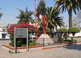
 Tlalnepantla is a big modern city with an important mall (Mundo E) and hotels: Crowne Plaza Lancaster, Camino Real, Fiesta Inn, NH hotel, Holiday Inn, and Four Points by Sheraton. Tlalnepantla offers different options for entertainment and food; Punta Recoleta Restaurante (Argentinian food), Boca del Rio (Mexican food restaurant), Real de Catorce (Show and Mexican food restaurant), La Antigua (Mexican food restaurant).
The most important avenues and boulevards in Tlalnepantla City are:
As well as the Periférico and the Mexico-Querétaro
Freeway with 12 lanes in Tlalnepantla. (This is a section of Mexican Federal Highway
57, the Pan-American Highway
)
Tlanepantla is well served by the local pesero
, intercity bus network and the suburban train.
Schools located in the city include:
and Monterrey
, ranking first in the State of Mexico. The most common industries include food processing, bottling, tobacco products, textiles, paper products, non-metallic mineral products and metals, chemicals and petroleum products, machinery and wood products. Its industrial zone is one of the largest in the country. The area also include more than 15,000 retail businesses which includes the Mundo E Mall and several large tianguis
.
 The church and monastery of Corpus Christi was built by both Mexica
s and Otomis of pink and gray stone. The side gate, called the Porciúncula, shows clearly the influence of both these peoples. In 1963, the church gain cathedral status.
The aqueduct that extends from Tlalnepantla to Villa de Guadalupe as well as the Caja del Agua are works that date from the colonial period. The Hacienda of Santa Mónica and the Hacienda de Enmedio are well-preserved. The Centro Cultural Sor Juana Inés de la Cruz has a collection of 130 fotografías del Tlalnepantla from the end of the 19th century to 1960 as well as other historical objects.
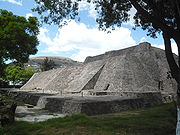
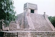 Two notable pyramids lies in the municipality's limits: Tenayuca
and Santa Cecilia Acatitlan
. The pyramid at Tenayuca is a smaller version of the Templo Mayor the Aztec
s built in Tenochtitlan. It has dual staircases on the west side, each leading to two temples, at the top of the pyramid. One was dedicated to Tlaloc
and the other to Huizilopochtli. Serpent scupltures surround the pyramid on three sides and are possibly of pre Aztec origin. A small museum on the grounds holds artifacts diagrams and models of the site and the history that surrounds it. Another, smaller pyramid is at Santa Cecilia Acatitlan, just north of Tenayuca. This one was rebuilt as the original was destroyed and some of it blocks were used to build the Santa Cecelia Parish church that is next to it. This pyramid has one staircase one temple atop. On the plaza is the Hurtado Museum, which houses a small collection of pre Hispanic sculpture.
The municipality was created in 1978 with the name of Tlalnepantla de Baz to honor Dr. Gustavo Baz Prada (1894–1987) who was a Zapatista
, governor of the State of Mexico and dean of the National Autonomous University of Mexico
. The municipality is made of two areas which are not continuous (the Zona Poniente, with a population of 653,453, and the Zona Oriente 19°33′07"N 99°05′53"W, with a population of 10,772, which are divided by the Gustavo A. Madero
borough of the Distrito Federal). The total municipal area is 83.48 km². The eastern side borders Ecatepec de Morelos
city and the Gustavo A. Madero
borough of Mexico City, and the western borders Naucalpan de Juarez Municipality on the southwest, Atizapán de Zaragoza Municipality
on the west, Cuautitlán Izcalli Municipality
and Tultitlán Municipality
on the north, the Gustavo A. Madero borough on the east, and the Azcapotzalco
borough on the south.
The three most important rivers in the municipality are:
The Sierra de Monte Alto is in the city itself but other significant elevations in the municipality include: Cerro del Tenayo, Cerro Grande and Cerro de la Cruz.
Significant locations within the municipality include the communities of San Jerónimo Tepetlacalco, Xocoyahualco, San Pablo Xalpa, San Bartolo Tenayuca, San Andrés Atenco, San Pablo Barrientos and San Juan Ixhuatepec.
The archaeological zones of Tenayuca
and Santa Cecilia Acatitlán
are located here as well, each of which has a museum. The pyramid at Tenayuca served as the model of the Templo Mayor in Tenochtitlan (now Mexico City).
Greater Mexico City
Greater Mexico City refers to the conurbation around Mexico City, officially called Mexico City Metropolitan Area , constituted by the Federal District—itself composed of 16 boroughs—and 41 adjacent municipalities of the states of Mexico and Hidalgo...
(Ciudad de Mexico). Tlalnepantla comes from the Náhuatl words tlalli (land) and nepantla (middle) to mean the middle land. The city was known in prior times as Tlalnepantla de Galeana and Tlalnepantla de Comonfort, to honor Hermenegildo Galeana
Hermenegildo Galeana
Hermenegildo Galeana was a hero of the Mexican War of Independence.Hermenegildo Galeana may also refer to:*Hermenegildo Galeana, Chihuahua, a town named in his honour*Hermenegildo Galeana, Puebla, a municipality...
and Ignacio Comonfort
Ignacio Comonfort
Ignacio Gregorio Comonfort de los Ríos was a Mexican politician and military officer who served as President of Mexico....
, respectively. The current addition of Baz comes from the last name of Gustavo Baz Prada, an important politician and soldier of Emiliano Zapata
Emiliano Zapata
Emiliano Zapata Salazar was a leading figure in the Mexican Revolution, which broke out in 1910, and which was initially directed against the president Porfirio Díaz. He formed and commanded an important revolutionary force, the Liberation Army of the South, during the Mexican Revolution...
's army during the Mexican Revolution
Mexican Revolution
The Mexican Revolution was a major armed struggle that started in 1910, with an uprising led by Francisco I. Madero against longtime autocrat Porfirio Díaz. The Revolution was characterized by several socialist, liberal, anarchist, populist, and agrarianist movements. Over time the Revolution...
. After the Revolution, Baz Prada became Governor of the State of Mexico and President of the National Autonomous University of Mexico (UNAM). It is located in the northeastern part of the State of Mexico, in the Valley of Mexico north of Mexico City
Mexico City
Mexico City is the Federal District , capital of Mexico and seat of the federal powers of the Mexican Union. It is a federal entity within Mexico which is not part of any one of the 31 Mexican states but belongs to the federation as a whole...
proper.
History
Around the 11th century, a people called the Amaquemecan (after whom the municipality of AmecamecaAmecameca
Amecameca is a town and municipality located in the eastern panhandle of Mexico State between Mexico City and the Iztaccíhuatl and Popocatépetl volcanos of the Sierra Nevada mountain range. It is located on federal highway 115 which leads to Cuautla, which is called the Volcano Route...
is named), migrated to this area following their leader Xolotl
Xolotl
In Aztec mythology, Xolotl was the god with associations to both lightning and death.Although often depicted in relation to the underworld, Xolotl was not a psychopomp in the Western sense. Xolotl did, however, aid the dead on their journey to Mictlan, the afterlife in some myths.Xolotl was also...
to look for a better climate and more food to sustain themselves. This same Xolotl founded the Tenayuca Oztopolco chiefdom and made the first census ever in the Americas. The Acolhua
Acolhua
The Acolhua are a Mesoamerican people who arrived in the Valley of Mexico in or around the year 1200 CE. The Acolhua were a sister culture of the Aztecs as well as the Tepanec, Chalca, Xochimilca and others....
s, Tepanecas and Otomi
Otomi people
The Otomi people . Smaller Otomi populations exist in the states of Puebla, Mexico, Tlaxcala, Michoacán and Guanajuato. The Otomi language belonging to the Oto-Pamean branch of the Oto-Manguean language family is spoken in many different varieties some of which are not mutually intelligible.One of...
s were already established in this land so alliances were made. Despite of this, the region eventually was conquered and made a tributary of the Aztec empire. After the Spanish Conquest, the area was evangelized by the Franciscans. The founding of modern Tlalnepantla was the result of a dispute between the towns of Tenayuca and Teocalhueyacan as to which should be the site of Franciscan monastery and religious center for the area. The result was to place the monastery at the midpoint between these two towns, and hence the name (middle land). This monastery, named Corpus Christi was built in 1550. After independence, Tlalnepantla was originally part of Mexico City, but in 1825, it was recognized as a district of the State of Mexico. During the Presidency of Porfirio Díaz Mori
Porfirio Díaz
José de la Cruz Porfirio Díaz Mori was a Mexican-American War volunteer and French intervention hero, an accomplished general and the President of Mexico continuously from 1876 to 1911, with the exception of a brief term in 1876 when he left Juan N...
, Tlalnepantla began industrial development, and in the 1950s underwent a demographic explosion after being declared a city in 1948. The population as of the 2010 INEGI census was 653,410 people, representing 98.37% of municipal population.
Infrastructure
The most important avenues and boulevards in Tlalnepantla City are:
- Gustavo Baz Ave.
- Mario Colin Ave.
- Adolfo Lopez Mateos Blvd.
- Presidente Juárez Ave.
As well as the Periférico and the Mexico-Querétaro
Querétaro
Querétaro officially Estado Libre y Soberano de Querétaro de Arteaga is one of the 31 states which, with the Federal District, comprise the 32 Federal Entities of Mexico. It is divided into 18 municipalities and its capital city is Santiago de Querétaro....
Freeway with 12 lanes in Tlalnepantla. (This is a section of Mexican Federal Highway
Mexican Federal Highway
Mexican Federal Highways, are roads maintained and built by the federal government of Mexico, through the Secretariat of Communications and Transportation ....
57, the Pan-American Highway
Pan-American Highway
The Pan-American Highway is a network of roads measuring about in total length. Except for an rainforest break, called the Darién Gap, the road links the mainland nations of the Americas in a connected highway system. According to Guinness World Records, the Pan-American Highway is the world's...
)
Tlanepantla is well served by the local pesero
Pesero
A pesero is a form of public transport, most commonly seen in Mexico City. Its name derives from the fact that the first incarnations of this form of transport charged a flat fee of one peso per ride .First seen in the 1970's as the so-called taxi colectivo , peseros were originally...
, intercity bus network and the suburban train.
Schools located in the city include:
- ℚ UNAM, Facultad de Estudios Superiores Iztacala (F.E.S. Iztacala)
- ℚ National Autonomous University of Mexico
- ℚ Instituto Tecnológico de Tlalnepantla (ITTLA)
- ℚ Tlalnepantlas Institute of Technology
- ℚ Centro Universitario Emilio Cardenas (CUDEC)
- ℚ Escuela Bancaria y Comercial (EBC Tlalnepantla)
- ℚ Universidad Latinoamericana (ULA)
- ℚ Sistema Educativo Indoamericano (INDO)
- ℚ Centro Eleia
- ℚ Universidad Interamericana para el Desarrollo (UNID)
- ℚ Universidad de Cuautitlan Izcalli (UCI)
- ℚ Ateneo de Tlalnepantla
- ℚ Universidad ETAC (Escuela Técnica en Administración y Comercio
Economy
There are more than 2,700 industries located here, making Tlalnepantla one of the most industrialized areas in the country along with NaucalpanNaucalpan
Naucalpan, officially Naucalpan de Juárez, is a city and municipality located just northwest of Mexico City in adjoining Mexico State. The name Naucalpan comes from Nahuatl and means “place of the four neighborhoods or four houses. “de Juárez was added to the official name in 1874 in honor of...
and Monterrey
Monterrey
Monterrey , is the capital city of the northeastern state of Nuevo León in the country of Mexico. The city is anchor to the third-largest metropolitan area in Mexico and is ranked as the ninth-largest city in the nation. Monterrey serves as a commercial center in the north of the country and is the...
, ranking first in the State of Mexico. The most common industries include food processing, bottling, tobacco products, textiles, paper products, non-metallic mineral products and metals, chemicals and petroleum products, machinery and wood products. Its industrial zone is one of the largest in the country. The area also include more than 15,000 retail businesses which includes the Mundo E Mall and several large tianguis
Tianguis
A tianguis is an open air market or bazaar that is traditionally held on certain market days in a town or city neighborhood in Mexico and Central America. This bazaar tradition has its roots well into the pre-Hispanic period and continues in many cases essentially unchanged into the present day....
.
Notable Sites
Mexica
The Mexica were a pre-Columbian people of central Mexico.Mexica may also refer to:*Mexica , a board game designed by Wolfgang Kramer and Michael Kiesling*Mexica , a 2005 novel by Norman Spinrad...
s and Otomis of pink and gray stone. The side gate, called the Porciúncula, shows clearly the influence of both these peoples. In 1963, the church gain cathedral status.
The aqueduct that extends from Tlalnepantla to Villa de Guadalupe as well as the Caja del Agua are works that date from the colonial period. The Hacienda of Santa Mónica and the Hacienda de Enmedio are well-preserved. The Centro Cultural Sor Juana Inés de la Cruz has a collection of 130 fotografías del Tlalnepantla from the end of the 19th century to 1960 as well as other historical objects.
Tenayuca
Tenayuca is a pre-Columbian Mesoamerican archaeological site in the Valley of Mexico. In the Postclassic period of Mesoamerican chronology Tenayuca was a settlement on the former shoreline of the western arm of Lake Texcoco, located approximately 10km to the northwest of Tenochtitlan...
and Santa Cecilia Acatitlan
Santa Cecilia Acatitlan
Acatitlan is an archeological zone of the early Aztec culture located in the town of Santa Cecilia, in the municipality of Tlalnepantla de Baz in Mexico State, about 10 km northwest of Mexico City...
. The pyramid at Tenayuca is a smaller version of the Templo Mayor the Aztec
Aztec
The Aztec people were certain ethnic groups of central Mexico, particularly those groups who spoke the Nahuatl language and who dominated large parts of Mesoamerica in the 14th, 15th and 16th centuries, a period referred to as the late post-classic period in Mesoamerican chronology.Aztec is the...
s built in Tenochtitlan. It has dual staircases on the west side, each leading to two temples, at the top of the pyramid. One was dedicated to Tlaloc
Tlaloc
Tlaloc was an important deity in Aztec religion, a god of rain, fertility, and water. He was a beneficent god who gave life and sustenance, but he was also feared for his ability to send hail, thunder and lightning, and for being the lord of the powerful element of water. In Aztec iconography he...
and the other to Huizilopochtli. Serpent scupltures surround the pyramid on three sides and are possibly of pre Aztec origin. A small museum on the grounds holds artifacts diagrams and models of the site and the history that surrounds it. Another, smaller pyramid is at Santa Cecilia Acatitlan, just north of Tenayuca. This one was rebuilt as the original was destroyed and some of it blocks were used to build the Santa Cecelia Parish church that is next to it. This pyramid has one staircase one temple atop. On the plaza is the Hurtado Museum, which houses a small collection of pre Hispanic sculpture.
The municipality
The city contains 98.37% of the municipality's population, although there are extensive areas in localities outside the city with relatively low population density, particularly in its eastern zone. The city of Tlalnepantla has governing jurisdiction over only four other communities: Puerto Escondido (Tepeolulco Pto. Escondido), Colonia la Agüita Sección las Maravillas, Ejido de Tenayuca (Cola de Caballo), and Ejido San Pedro Xalostoc (El Cuervo). Less than 2% of the municipality's population is located outside of the city proper.The municipality was created in 1978 with the name of Tlalnepantla de Baz to honor Dr. Gustavo Baz Prada (1894–1987) who was a Zapatista
Liberation Army of the South
The Liberation Army of the South was an armed group formed and led by Emiliano Zapata that took part in the Mexican Revolution. The force was commonly known as the Zapatistas....
, governor of the State of Mexico and dean of the National Autonomous University of Mexico
National Autonomous University of Mexico
The Universidad Nacional Autónoma de México is a university in Mexico. UNAM was founded on 22 September 1910 by Justo Sierra as a liberal alternative to the Roman Catholic-sponsored Royal and Pontifical University of Mexico The Universidad Nacional Autónoma de México (UNAM) (National Autonomous...
. The municipality is made of two areas which are not continuous (the Zona Poniente, with a population of 653,453, and the Zona Oriente 19°33′07"N 99°05′53"W, with a population of 10,772, which are divided by the Gustavo A. Madero
Gustavo A. Madero, D.F.
Gustavo A. Madero is one of the 16 delegaciones into which Mexico's Federal District is divided.-Origins:Founded as "Villa de Guadalupe" in 1563, it became the city of "Villa de Guadalupe Hidalgo" in 1828, and finally a delegación in 1931; as such, it was named after Gustavo A. Madero, the brother...
borough of the Distrito Federal). The total municipal area is 83.48 km². The eastern side borders Ecatepec de Morelos
Ecatepec de Morelos
Ecatepec City, once officially San Cristóbal Ecatepec de Morelos, is a city in the State of México and the seat of Ecatepec de Morelos Municipality; however, both the city and the municipality are often known simply as "Ecatepec". The name "Ecatepec" is derived from Nahuatl, and means "windy hill"....
city and the Gustavo A. Madero
Gustavo A. Madero, D.F.
Gustavo A. Madero is one of the 16 delegaciones into which Mexico's Federal District is divided.-Origins:Founded as "Villa de Guadalupe" in 1563, it became the city of "Villa de Guadalupe Hidalgo" in 1828, and finally a delegación in 1931; as such, it was named after Gustavo A. Madero, the brother...
borough of Mexico City, and the western borders Naucalpan de Juarez Municipality on the southwest, Atizapán de Zaragoza Municipality
Ciudad López Mateos
Ciudad López Mateos is a city in the State of México, México, and the seat of the municipality called Atizapán de Zaragoza. The municipality takes its name from the nahuatl word Ātīzapan, which is formed by three words: "ā-tl", which means "water", "tīza-tl", which means "white clay" and "īpan",...
on the west, Cuautitlán Izcalli Municipality
Cuautitlán Izcalli
Cuautitlán Izcalli is a city and municipality in Mexico State, Mexico. The name comes from Náhuatl and means 'your house between the trees.' -City and municipal seat:...
and Tultitlán Municipality
Tultitlán de Mariano Escobedo
Tultitlán de Mariano Escobedo is the seat of the municipality of Tultitlán located in the northeastern part of the state of México in Mexico. It lies adjacent to the northern tip of the Federal District and is part of the Greater Mexico City urban area...
on the north, the Gustavo A. Madero borough on the east, and the Azcapotzalco
Azcapotzalco
Azcapotzalco is one of the 16 delegaciones into which Mexico's Federal District is divided. Azcapotzalco is in the northwestern part of Mexico City...
borough on the south.
The three most important rivers in the municipality are:
- Río de los Remedios
- Río San Javier
- Río Tlalnepantla
The Sierra de Monte Alto is in the city itself but other significant elevations in the municipality include: Cerro del Tenayo, Cerro Grande and Cerro de la Cruz.
Significant locations within the municipality include the communities of San Jerónimo Tepetlacalco, Xocoyahualco, San Pablo Xalpa, San Bartolo Tenayuca, San Andrés Atenco, San Pablo Barrientos and San Juan Ixhuatepec.
The archaeological zones of Tenayuca
Tenayuca
Tenayuca is a pre-Columbian Mesoamerican archaeological site in the Valley of Mexico. In the Postclassic period of Mesoamerican chronology Tenayuca was a settlement on the former shoreline of the western arm of Lake Texcoco, located approximately 10km to the northwest of Tenochtitlan...
and Santa Cecilia Acatitlán
Santa Cecilia Acatitlan
Acatitlan is an archeological zone of the early Aztec culture located in the town of Santa Cecilia, in the municipality of Tlalnepantla de Baz in Mexico State, about 10 km northwest of Mexico City...
are located here as well, each of which has a museum. The pyramid at Tenayuca served as the model of the Templo Mayor in Tenochtitlan (now Mexico City).
Towns and villages
Localities (cities, towns, and villages) are:| Name | 2010 Census Population |
|---|---|
| Tlalnepantla de Baz Tlalnepantla de Baz Tlalnepantla de Baz is a city and a municipality of the State of Mexico in the north of Mexico City . Tlalnepantla comes from the Náhuatl words tlalli and nepantla to mean the middle land... |
653,410 |
| Puerto Escondido (Tepeolulco Puerto Escondido) | 10,717 |
| Colonia la Agüita Sección las Maravillas | 50 |
| Ejido de Tenayuca (Cola de Caballo) | 43 |
| Ejido San Pedro Xalostoc (El Cuervo) | 5 |
| Total Municipality | 664,225 |