
Pit River
Encyclopedia
The Pit River is a major river draining from northeastern California
into the state's Central Valley. The Pit, the Klamath
and the Columbia
are the only three rivers in the U.S. that cross the Cascade Range
.
The longest tributary of the Sacramento River
, it contributes as much as eighty percent of their combined water volume into Lake Shasta; the junction of their Lake Shasta arms is 4 miles (6.4 km) northeast of Shasta Dam
. The main stem of the Pit River is 207 miles (333.1 km) long, and some water in the system flows 315 miles (506.9 km) to the Sacramento River measuring from the Pit River's longest source.
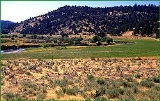
The Pit River drains a sparsely-populated volcanic highlands area, passing through the south end of the Cascade Range in a deep canyon northeast of Redding
. The river is so named because of the pits the Achumawi
dug to trap game that came to water at the river.
, Lassen
and Shasta
counties in the northeastern corner of California. Originating in the Warner Mountains. The 58 miles (93.3 km) South Fork Pit River - West Valley Creek - Cedar Creek source originates just southeast of Buck Mountain in the Warner Mountains
in the extreme southeastern corner of the Modoc National Forest
9 miles (14.5 km) west of the Nevada
border. The South Fork is formed from the confluence of several creeks in Jess Valley 13 miles (20.9 km) northeast of Madeline
and flows west through a narrow canyon, past Likely
, then generally through a broad ranching valley where its waters are diverted for irrigation and waterfowl conservation in an extensive system of canals. The 30 miles (48.3 km) long North Fork - Linnville Creek tributary begins 5 miles (8 km) southeast of the town of Davis Creek. It flows generally south-southwest, joining the South Fork from the north near Alturas
.
The combined river flows west-southwest in a winding course across Modoc County, past Canby
and through the Modoc National Forest
in the narrow Stonecoal Valley gorge. It turns south to flow past Lookout
and into northern Lassen County
, past Bieber
to emerge into the ranching region of Big Valley. North of Little Valley
it runs east into northeastern Shasta County
, passing through the Cascades in a serpentine canyon in the Shasta National Forest. It flows through the Fall River Valley Joining the Fall River. Together they span much of the Valley forming one of the largest systems of fresh water springs in the country while passing through the Town of Fall River Mills
and culminating in two spectacular waterfalls. It then flows south to join the Sacramento River
as the eastern arm of Shasta Lake
reservoir, approximately 15 mi (24 km) north of Redding. The lower 30 mi (50 km) of the river forms the longest of the five arms of Lake Shasta, which is formed by Shasta Dam
on the Sacramento downstream from the original confluence.
The river is a popular destination for fly fishing
, rafting
in its lower reaches, and is used for hydroelectric energy
both in the powerhouses below Fall River Mills
and at Shasta Dam. It is also used extensively for irrigation
and conservation purposes.
territory, who lived in the area expanding from Big Bend
to Goose Lake
. The military Pitt River Expedition
s against local Indian Tribes occurred during the 1850s.
California
California is a state located on the West Coast of the United States. It is by far the most populous U.S. state, and the third-largest by land area...
into the state's Central Valley. The Pit, the Klamath
Klamath River
The Klamath River is an American river that flows southwest through Oregon and northern California, cutting through the Cascade Range to empty into the Pacific Ocean. The river drains an extensive watershed of almost that stretches from the high desert country of the Great Basin to the temperate...
and the Columbia
Columbia River
The Columbia River is the largest river in the Pacific Northwest region of North America. The river rises in the Rocky Mountains of British Columbia, Canada, flows northwest and then south into the U.S. state of Washington, then turns west to form most of the border between Washington and the state...
are the only three rivers in the U.S. that cross the Cascade Range
Cascade Range
The Cascade Range is a major mountain range of western North America, extending from southern British Columbia through Washington and Oregon to Northern California. It includes both non-volcanic mountains, such as the North Cascades, and the notable volcanoes known as the High Cascades...
.
The longest tributary of the Sacramento River
Sacramento River
The Sacramento River is an important watercourse of Northern and Central California in the United States. The largest river in California, it rises on the eastern slopes of the Klamath Mountains, and after a journey south of over , empties into Suisun Bay, an arm of the San Francisco Bay, and...
, it contributes as much as eighty percent of their combined water volume into Lake Shasta; the junction of their Lake Shasta arms is 4 miles (6.4 km) northeast of Shasta Dam
Shasta Lake, California
Shasta Lake or Shasta Lake City is a city in Shasta County, California, United States. It is the closest settlement to Lake Shasta and the Shasta Dam, which are popular tourist destinations...
. The main stem of the Pit River is 207 miles (333.1 km) long, and some water in the system flows 315 miles (506.9 km) to the Sacramento River measuring from the Pit River's longest source.
The Pit River drains a sparsely-populated volcanic highlands area, passing through the south end of the Cascade Range in a deep canyon northeast of Redding
Redding, California
Redding is a city in far-Northern California. It is the county seat of Shasta County, California, USA. With a population of 89,861, according to the 2010 Census...
. The river is so named because of the pits the Achumawi
Achomawi
The Achomawi are one of eleven bands of the Pit River tribe of Native Americans who lived in northeastern California, USA....
dug to trap game that came to water at the river.
Description
The Pit River rises in several forks in ModocModoc County, California
Modoc County is a county located in the far northeast corner of the U.S. state of California, bounded by the state of Oregon to the north and the state of Nevada to the east. As of the 2010 census, its population was 9,686, up from 9,449 at the 2000 census. The current county seat is Alturas, the...
, Lassen
Lassen County, California
Lassen County is a county located in the northeastern portion of the U.S. state of California. As of the 2010 census, the population was 34,895, up from 33,828 at the 2000 census...
and Shasta
Shasta County, California
Shasta County is a county located in the northern portion of the U.S. state of California. The county occupies the northern reaches of the Sacramento Valley, with portions extending into the southern reaches of the Cascade Range. As of the 2010 census, the population was 177,223, up from 163,256...
counties in the northeastern corner of California. Originating in the Warner Mountains. The 58 miles (93.3 km) South Fork Pit River - West Valley Creek - Cedar Creek source originates just southeast of Buck Mountain in the Warner Mountains
Warner Mountains
The Warner Mountains are an 85-mile-long mountain range running north-south through northeastern California and extending into southern Oregon in the United States...
in the extreme southeastern corner of the Modoc National Forest
Modoc National Forest
Modoc National Forest is a national forest in northeastern California, covering parts of Modoc , Lassen , and Siskiyou counties. Most of the forest was covered by an immense lava flow millions of years ago. The eastern part of the forest east of Alturas contains a spur of the Cascade Range to...
9 miles (14.5 km) west of the Nevada
Nevada
Nevada is a state in the western, mountain west, and southwestern regions of the United States. With an area of and a population of about 2.7 million, it is the 7th-largest and 35th-most populous state. Over two-thirds of Nevada's people live in the Las Vegas metropolitan area, which contains its...
border. The South Fork is formed from the confluence of several creeks in Jess Valley 13 miles (20.9 km) northeast of Madeline
Madeline, California
Madeline is an unincorporated community in Lassen County, California. It is located north-northeast of Susanville, at an elevation of 5321 feet ....
and flows west through a narrow canyon, past Likely
Likely, California
Likely is a census-designated place in Modoc County, California. It is located near the South Fork of the Pit River south of the county seat of Alturas, at an elevation of 4449 feet ....
, then generally through a broad ranching valley where its waters are diverted for irrigation and waterfowl conservation in an extensive system of canals. The 30 miles (48.3 km) long North Fork - Linnville Creek tributary begins 5 miles (8 km) southeast of the town of Davis Creek. It flows generally south-southwest, joining the South Fork from the north near Alturas
Alturas, California
Alturas is the county seat of Modoc County, California, United States. Alturas is located on the Pit River, east of the center of Modoc County, at an elevation of 4370 feet...
.
The combined river flows west-southwest in a winding course across Modoc County, past Canby
Canby, California
Canby is a census-designated place in Modoc County, California. It is located west of Alturas, at an elevation of 4314 feet . It had a population of 315 at the 2010 census. The ZIP Code is 96015...
and through the Modoc National Forest
Modoc National Forest
Modoc National Forest is a national forest in northeastern California, covering parts of Modoc , Lassen , and Siskiyou counties. Most of the forest was covered by an immense lava flow millions of years ago. The eastern part of the forest east of Alturas contains a spur of the Cascade Range to...
in the narrow Stonecoal Valley gorge. It turns south to flow past Lookout
Lookout, California
Lookout is a census-designated place in Modoc County, California. It is located west of Adin,at an elevation of 4144 feet . Lookout's ZIP Code is 96054....
and into northern Lassen County
Lassen County, California
Lassen County is a county located in the northeastern portion of the U.S. state of California. As of the 2010 census, the population was 34,895, up from 33,828 at the 2000 census...
, past Bieber
Bieber, California
Bieber is a census-designated place in Lassen County, California. It is located on the Pit River north-northwest of Susanville, at an elevation of 4124 feet . Its population was 312 at the 2010 census. The ZIP Code is 96009. The community is inside area code 530.-History:The settlement sprang up...
to emerge into the ranching region of Big Valley. North of Little Valley
Little Valley, California
Little Valley is an unincorporated community in Lassen County, California. It is located northwest of Susanville, at an elevation of 4190 feet ....
it runs east into northeastern Shasta County
Shasta County, California
Shasta County is a county located in the northern portion of the U.S. state of California. The county occupies the northern reaches of the Sacramento Valley, with portions extending into the southern reaches of the Cascade Range. As of the 2010 census, the population was 177,223, up from 163,256...
, passing through the Cascades in a serpentine canyon in the Shasta National Forest. It flows through the Fall River Valley Joining the Fall River. Together they span much of the Valley forming one of the largest systems of fresh water springs in the country while passing through the Town of Fall River Mills
Fall River Mills, California
Fall River Mills is an unincorporated town and census-designated place in Shasta County, California, United States. The population was 573 as of the 2010 census.-Production & Industry:The community is known for its agriculture...
and culminating in two spectacular waterfalls. It then flows south to join the Sacramento River
Sacramento River
The Sacramento River is an important watercourse of Northern and Central California in the United States. The largest river in California, it rises on the eastern slopes of the Klamath Mountains, and after a journey south of over , empties into Suisun Bay, an arm of the San Francisco Bay, and...
as the eastern arm of Shasta Lake
Shasta Lake
Shasta Lake, also called Lake Shasta, is an artificial lake created by the construction of Shasta Dam across the Sacramento River in the Shasta-Trinity National Forest of Shasta County, California...
reservoir, approximately 15 mi (24 km) north of Redding. The lower 30 mi (50 km) of the river forms the longest of the five arms of Lake Shasta, which is formed by Shasta Dam
Shasta Dam
Shasta Dam is an arch dam across the Sacramento River in the northern part of the U.S. state of California, at the north end of the Sacramento Valley. The dam mainly serves long-term water storage and flood control in its reservoir, Shasta Lake, and also generates hydroelectric power...
on the Sacramento downstream from the original confluence.
The river is a popular destination for fly fishing
Fly fishing
Fly fishing is an angling method in which an artificial 'fly' is used to catch fish. The fly is cast using a fly rod, reel, and specialized weighted line. Casting a nearly weightless fly or 'lure' requires casting techniques significantly different from other forms of casting...
, rafting
Whitewater
Whitewater is formed in a rapid, when a river's gradient increases enough to disturb its laminar flow and create turbulence, i.e. form a bubbly, or aerated and unstable current; the frothy water appears white...
in its lower reaches, and is used for hydroelectric energy
Hydroelectricity
Hydroelectricity is the term referring to electricity generated by hydropower; the production of electrical power through the use of the gravitational force of falling or flowing water. It is the most widely used form of renewable energy...
both in the powerhouses below Fall River Mills
Fall River Mills, California
Fall River Mills is an unincorporated town and census-designated place in Shasta County, California, United States. The population was 573 as of the 2010 census.-Production & Industry:The community is known for its agriculture...
and at Shasta Dam. It is also used extensively for irrigation
Irrigation
Irrigation may be defined as the science of artificial application of water to the land or soil. It is used to assist in the growing of agricultural crops, maintenance of landscapes, and revegetation of disturbed soils in dry areas and during periods of inadequate rainfall...
and conservation purposes.
Dams
The Pit River is impounded by several dams:- Pit 1 Dam
- Pit 3 DamPit 3 DamPit-3 Dam is a dam across the Pit River in northern California in the United States. It forms Lake Britton, which stretches upstream. The dam is used mainly to divert water into a penstock that runs about downstream to generate hydroelectricity...
- Pit 4 Dam
- Pit 5 Dam
- Pit 6 DamPit 6 DamPit No. 6 Dam or Pit 6 Dam is a hydroelectric dam on the Pit River in northern California. Its power station generates up to 79 MW....
- Pit 7 DamPit 7 DamPit 7 Dam is a run-of-the-river hydroelectric dam across the Pit River in northern California. Located just upstream of Shasta Lake, it is a concrete arch-gravity structure and its powerhouse has a capacity of 110 MW. The dam is owned by the Pacific Gas and Electric Company....
- Shasta DamShasta DamShasta Dam is an arch dam across the Sacramento River in the northern part of the U.S. state of California, at the north end of the Sacramento Valley. The dam mainly serves long-term water storage and flood control in its reservoir, Shasta Lake, and also generates hydroelectric power...
History
The Pit River is located in historical AchomawiAchomawi
The Achomawi are one of eleven bands of the Pit River tribe of Native Americans who lived in northeastern California, USA....
territory, who lived in the area expanding from Big Bend
Big Bend, California
Big Bend is a census-designated place in Shasta County, California, United States. The population was 102 at the 2010 census, down from 149 at the 2000 census.-Geography:Big Bend is located at ....
to Goose Lake
Goose Lake (Oregon-California)
Goose Lake is a large alkaline glacial lake located in the Goose Lake Valley on the Oregon-California border. The north end of the lake is in Lake County, Oregon and the south end is in Modoc County, California. The mountains at the north end of the lake are part of the Fremont National Forest...
. The military Pitt River Expedition
Pitt River Expedition
The Pitt River Expedition is the name given to several expeditions, detailed below. They were named for the Pit River and Pitt River Indians, as they were then called. . The Pit River is one of several tributaries of the Sacramento River...
s against local Indian Tribes occurred during the 1850s.