
Higger Tor
Encyclopedia
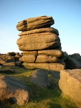
Higger Tor is a gritstone
tor in the Burbage Valley, in the Peak District
of England.
It stands in the county of South Yorkshire
, about 200 metre from the border with Derbyshire
, which runs along the nearest road, approximately 2 kilometres (1.2 mi) east of Hathersage
. Higger Tor overlooks the hill fort
of Carl Wark
to the southeast. It is believed to be an ancient fortification from the iron ages, possibly the 5th or 6th centuries BC.

Gritstone
Gritstone or Grit is a hard, coarse-grained, siliceous sandstone. This term is especially applied to such sandstones that are quarried for building material. British gritstone was used for millstones to mill flour, to grind wood into pulp for paper and for grindstones to sharpen blades. "Grit" is...
tor in the Burbage Valley, in the Peak District
Peak District
The Peak District is an upland area in central and northern England, lying mainly in northern Derbyshire, but also covering parts of Cheshire, Greater Manchester, Staffordshire, and South and West Yorkshire....
of England.
It stands in the county of South Yorkshire
South Yorkshire
South Yorkshire is a metropolitan county in the Yorkshire and the Humber region of England. It has a population of 1.29 million. It consists of four metropolitan boroughs: Barnsley, Doncaster, Rotherham, and City of Sheffield...
, about 200 metre from the border with Derbyshire
Derbyshire
Derbyshire is a county in the East Midlands of England. A substantial portion of the Peak District National Park lies within Derbyshire. The northern part of Derbyshire overlaps with the Pennines, a famous chain of hills and mountains. The county contains within its boundary of approx...
, which runs along the nearest road, approximately 2 kilometres (1.2 mi) east of Hathersage
Hathersage
Hathersage is a village in the Derbyshire Peak District, in England. It lies on the north bank of the River Derwent, approximately 10 miles west of Sheffield...
. Higger Tor overlooks the hill fort
Hill fort
A hill fort is a type of earthworks used as a fortified refuge or defended settlement, located to exploit a rise in elevation for defensive advantage. They are typically European and of the Bronze and Iron Ages. Some were used in the post-Roman period...
of Carl Wark
Carl Wark
Carl Wark is a rocky promontory on Hathersage Moor in the Peak District National Park, just inside the boundary of Sheffield, England. The promontory is faced by vertical cliffs on all but one side, which is protected by a prehistoric embankment...
to the southeast. It is believed to be an ancient fortification from the iron ages, possibly the 5th or 6th centuries BC.