
Ohakune
Encyclopedia
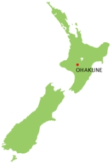
Ohakune is a town in the North Island
of New Zealand
. It is located at the southern end of the Tongariro National Park
, close to the southwestern slopes of the active volcano
Mount Ruapehu
. Part of the Manawatu-Wanganui
region, the town is 70 kilometres northeast of Wanganui
, and 25 kilometres west of Waiouru
. As of May 2003 the population for Ohakune was 1293.
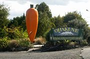
, which celebrates the area's reputation as the source of a high proportion of New Zealand's carrots. This is reputedly the world's largest model carrot.
runs through the town, as does the North Island Main Trunk Railway. From 18 December 1917 until 1 January 1968, Ohakune was also the junction for the Raetihi Branch, a branch line
railway to Raetihi
. A truss bridge formerly used by this branch still stands near the big carrot.
Seventeen kilometres to the east of the town is the Tangiwai bridge, site of New Zealand's worst railway accident
, on December 24, 1953.
skifield. The town's population is 1101 (2006 census).
 Ohakune has hosted the Big Mountain Short Film Festival
since 2006.
The Ohakune Mountain Mardi Gras is also a major event held each year. It is one of the premier ski parties of the season and is a celebration of winter and the ski season. Ohakune comes alive with this street party as musicians, stalls and rides are set up for the flood of people. It has been running for several years and has had numbers steadily increase, with 2009's event featuring major New Zealand musicians such as band Midnight Youth and DJ General Lee.
Ohakune is an essential part of Fallout Festival an annual event that focuses on bringing creative elements into the community to celebrate the snow season.
Ohakune is the home of radio station Zero FM (94.2fm Ohakune)
The world's first commercial bungy jumping site was established just outside Ohakune at the old railway viaduct. This was operated during the 1980s until the bridge became too unsafe to continue operations. This bridge is now restored and a highlight of the 'Old Coach Road' walk/bikeway.
North Island
The North Island is one of the two main islands of New Zealand, separated from the much less populous South Island by Cook Strait. The island is in area, making it the world's 14th-largest island...
of New Zealand
New Zealand
New Zealand is an island country in the south-western Pacific Ocean comprising two main landmasses and numerous smaller islands. The country is situated some east of Australia across the Tasman Sea, and roughly south of the Pacific island nations of New Caledonia, Fiji, and Tonga...
. It is located at the southern end of the Tongariro National Park
Tongariro National Park
Tongariro National Park is the oldest national park in New Zealand, located in the central North Island. It has been acknowledged by UNESCO as one of the 28 mixed cultural and natural World Heritage Sites....
, close to the southwestern slopes of the active volcano
Volcano
2. Bedrock3. Conduit 4. Base5. Sill6. Dike7. Layers of ash emitted by the volcano8. Flank| 9. Layers of lava emitted by the volcano10. Throat11. Parasitic cone12. Lava flow13. Vent14. Crater15...
Mount Ruapehu
Mount Ruapehu
Mount Ruapehu, or just Ruapehu, is an active stratovolcano at the southern end of the Taupo Volcanic Zone in New Zealand. It is 23 kilometres northeast of Ohakune and 40 kilometres southwest of the southern shore of Lake Taupo, within Tongariro National Park...
. Part of the Manawatu-Wanganui
Manawatu-Wanganui
Manawatu-Wanganui is a region in the lower half of the North Island of New Zealand, around the cities of Palmerston North and Whanganui. It is administered by the Horizons Regional Council.-Administration:...
region, the town is 70 kilometres northeast of Wanganui
Wanganui
Whanganui , also spelled Wanganui, is an urban area and district on the west coast of the North Island of New Zealand. It is part of the Manawatu-Wanganui region....
, and 25 kilometres west of Waiouru
Waiouru
Waiouru is a small town in the centre of the North Island of New Zealand. It is on the North Island Volcanic Plateau, 25 kilometres south-east of Mount Ruapehu, and in the Ruapehu District....
. As of May 2003 the population for Ohakune was 1293.
Southern Entrance
On the eastern edge of the town there is a large replica of a carrotCarrot
The carrot is a root vegetable, usually orange in colour, though purple, red, white, and yellow varieties exist. It has a crisp texture when fresh...
, which celebrates the area's reputation as the source of a high proportion of New Zealand's carrots. This is reputedly the world's largest model carrot.
Transportation
State Highway 49New Zealand State Highway 49
State Highway 49 is a New Zealand State Highway, linking State Highway 4 and State Highway 1, via the tourist town of Ohakune. It forms the southern part of the ring road surrounding Tongariro National Park, and provides access to the southern side of Mount Ruapehu and the Turoa skifield.State...
runs through the town, as does the North Island Main Trunk Railway. From 18 December 1917 until 1 January 1968, Ohakune was also the junction for the Raetihi Branch, a branch line
Branch line
A branch line is a secondary railway line which branches off a more important through route, usually a main line. A very short branch line may be called a spur line...
railway to Raetihi
Raetihi
Raetihi is a town in the central North Island of New Zealand. It is located at the junction of State Highways 4 and 49, 11 kilometres west of Ohakune. The 2006 New Zealand Census of Population and Dwellings recorded its population as 1,035. This constitutes a decrease of 3.4% or 36 people since...
. A truss bridge formerly used by this branch still stands near the big carrot.
Seventeen kilometres to the east of the town is the Tangiwai bridge, site of New Zealand's worst railway accident
Tangiwai disaster
The Tangiwai disaster on 24 December 1953 was the worst rail accident in New Zealand history. An 11-carriage overnight express from Wellington to Auckland fell into the Whangaehu River at Tangiwai, ten kilometres west of Waiouru. The bridge carrying the North Island Main Trunk Railway over the...
, on December 24, 1953.
Town Activities
It is a rural service town and a base for skiers using the TuroaTuroa
Turoa is a large skifield on the south western side of Mount Ruapehu, the highest mountain in the North Island of New Zealand, in Tongariro National Park. The area has been used for skiing since before the completion of the Mountain Road, but the first lifts opened in 1978.There are two beginner...
skifield. The town's population is 1101 (2006 census).
- Accommodation
- Snow sports
- Mountain tramping
- Bushwalking
Big Mountain Short Film Festival
The Big Mountain Short Film Festival is a short film festival based in Ohakune, New Zealand designed to encourage and celebrate creative short film making and storytelling. Entry is free and open to filmmakers internationally, who are encouraged to use maximum creativity on minimum budget...
since 2006.
The Ohakune Mountain Mardi Gras is also a major event held each year. It is one of the premier ski parties of the season and is a celebration of winter and the ski season. Ohakune comes alive with this street party as musicians, stalls and rides are set up for the flood of people. It has been running for several years and has had numbers steadily increase, with 2009's event featuring major New Zealand musicians such as band Midnight Youth and DJ General Lee.
Ohakune is an essential part of Fallout Festival an annual event that focuses on bringing creative elements into the community to celebrate the snow season.
Ohakune is the home of radio station Zero FM (94.2fm Ohakune)
Trivia
A mock-romantic song from the mid 1960s called September in Ohakune was recorded by Peter Harcourt on an LP called Land of the Long White ShroudThe world's first commercial bungy jumping site was established just outside Ohakune at the old railway viaduct. This was operated during the 1980s until the bridge became too unsafe to continue operations. This bridge is now restored and a highlight of the 'Old Coach Road' walk/bikeway.