
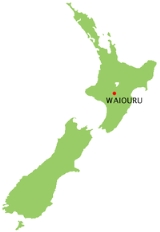
Waiouru
Encyclopedia
North Island
The North Island is one of the two main islands of New Zealand, separated from the much less populous South Island by Cook Strait. The island is in area, making it the world's 14th-largest island...
of New Zealand
New Zealand
New Zealand is an island country in the south-western Pacific Ocean comprising two main landmasses and numerous smaller islands. The country is situated some east of Australia across the Tasman Sea, and roughly south of the Pacific island nations of New Caledonia, Fiji, and Tonga...
. It is on the North Island Volcanic Plateau
North Island Volcanic Plateau
The North Island Volcanic Plateau is a volcanic plateau covering much of central North Island of New Zealand with volcanoes, lava plateaus, and crater lakes....
, 25 kilometres south-east of Mount Ruapehu
Mount Ruapehu
Mount Ruapehu, or just Ruapehu, is an active stratovolcano at the southern end of the Taupo Volcanic Zone in New Zealand. It is 23 kilometres northeast of Ohakune and 40 kilometres southwest of the southern shore of Lake Taupo, within Tongariro National Park...
, and in the Ruapehu District
Ruapehu District
Ruapehu District is a territorial authority near the centre of New Zealand's North Island.It has an area of 6,730.185 square kilometers and a population of 13,569 at the 2006 census .-Features:...
.
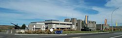
The main attraction of Waiouru is the Queen Elizabeth II Army Memorial Museum
QEII Army Memorial Museum
The National Army Museum is the museum of the New Zealand Army. It was formerly known as the Queen Elizabeth II Army Memorial Museum. It is situated 94 minutes south of Taupo on State Highway One, on the southern side of the small military town of Waiouru. The 1300 square metre museum is...
, opened in 1978, which features static displays of New Zealand's military heritage. The rest of the township consists of a small cluster of a police station, two garages, a petrol station/postal agency, a panel beater, two motels, a tavern and half a dozen cafe/restaurants spread along the highway. There are three unmanned diesel refueling sites for the 700+ big freight trucks that pass through Waiouru each day. Nearby are the yards of a roading contractor and a maintenance contractor. A grocery store, hairdresser and beautician are in the Army housing area two kilometres away, and a medical centre, public library, cafe and department store are inside the army camp.
North of Waiouru is the section of State Highway 1
State Highway 1 (New Zealand)
State Highway 1 is the longest and most significant road in the New Zealand roading network, running the length of both main islands. It appears on road maps as SH 1 and on road signs as a white number 1 on a red shield, but it has the official designations SH 1N in the North Island, SH 1S in the...
called the Desert Road. This runs for 35 km through the Rangipo Desert
Rangipo Desert
Rangipo Desert is a barren desert-like environment in New Zealand, located in the Ruapehu District on the North Island Volcanic Plateau; to the east of the three active peaks of Mount Tongariro, Mount Ngauruhoe, and Mount Ruapehu, and to the west of the Kaimanawa Range.The Rangipo Desert receives...
to Turangi
Turangi
Turangi is a small town on the west bank of the Tongariro River, 50 kilometres south-west of Taupo on the North Island Volcanic Plateau of New Zealand. It was built to accommodate the workers associated with the Tongariro hydro-electric power development project and their families...
, at the southern end of Lake Taupo
Lake Taupo
Lake Taupo is a lake situated in the North Island of New Zealand. With a surface area of , it is the largest lake by surface area in New Zealand, and the second largest freshwater lake by surface area in geopolitical Oceania after Lake Murray ....
. Waiouru is a military
Military
A military is an organization authorized by its greater society to use lethal force, usually including use of weapons, in defending its country by combating actual or perceived threats. The military may have additional functions of use to its greater society, such as advancing a political agenda e.g...
town that has grown up in conjunction with the New Zealand Army
New Zealand Army
The New Zealand Army , is the land component of the New Zealand Defence Force and comprises around 4,500 Regular Force personnel, 2,000 Territorial Force personnel and 500 civilians. Formerly the New Zealand Military Forces, the current name was adopted around 1946...
Camp
Waiouru Army Camp
The Waiouru Army Camp is a base of the New Zealand Army in the central North Island near Waiouru.Waiouru is often referred to by soldiers as the home of the army as it houses the army marae and is the base where all New Zealand Army soldiers complete their initial basic training called All Arms...
and the Training Group (ATG), which is responsible for the training of recruits and other soldiers. The Desert Road immediately north of Waiouru runs through the 870 km² army training area, which lies mainly to the east of the road. The Royal NZ Navy's Irirangi communications station with its huge antennae is 2 km north of Waiouru.
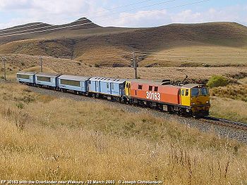
Waiouru is on the North Island Main Trunk Railway, which came through in 1907. Waiouru Railway Station is the highest station (814 m) on the New Zealand rail system
Rail transport in New Zealand
Rail transport in New Zealand consists of a network of gauge railway lines in both the North and South Islands. Rail services are focused primarily on freight, particularly bulk freight, with limited passenger services on some lines...
. The Overlander no longer (from April 2005) stops at Waiouru.
Seven kilometres to the west of Waiouru is the small settlement of Tangiwai, the site of New Zealand's worst railway disaster
Tangiwai disaster
The Tangiwai disaster on 24 December 1953 was the worst rail accident in New Zealand history. An 11-carriage overnight express from Wellington to Auckland fell into the Whangaehu River at Tangiwai, ten kilometres west of Waiouru. The bridge carrying the North Island Main Trunk Railway over the...
. On December 24, 1953 the overnight express from Wellington
Wellington
Wellington is the capital city and third most populous urban area of New Zealand, although it is likely to have surpassed Christchurch due to the exodus following the Canterbury Earthquake. It is at the southwestern tip of the North Island, between Cook Strait and the Rimutaka Range...
to Auckland
Auckland
The Auckland metropolitan area , in the North Island of New Zealand, is the largest and most populous urban area in the country with residents, percent of the country's population. Auckland also has the largest Polynesian population of any city in the world...
passed over Tangiwai railway bridge just after it had been weakened by a lahar
Lahar
A lahar is a type of mudflow or debris flow composed of a slurry of pyroclastic material, rocky debris, and water. The material flows down from a volcano, typically along a river valley. The term is a shortened version of "berlahar" which originated in the Javanese language of...
from Mount Ruapehu
Mount Ruapehu
Mount Ruapehu, or just Ruapehu, is an active stratovolcano at the southern end of the Taupo Volcanic Zone in New Zealand. It is 23 kilometres northeast of Ohakune and 40 kilometres southwest of the southern shore of Lake Taupo, within Tongariro National Park...
. The bridge collapsed, sending the train into the Whangaehu River
Whangaehu River
The Whangaehu River is a large river in central North Island of New Zealand. Its headwaters are the crater lake of Mount Ruapehu on the central plateau, and it flows into the Tasman Sea eight kilometres southeast of Wanganui.-Length:...
, killing 151 people. Many army and naval personnel were involved in the rescue of survivors and the recovery of bodies. Sister Mortimer of the Waiouru Camp Hospital, "The Angel of Tangiwai," worked non-stop for three days tending the survivors and laying out the bodies. (Gregory 2003)
History
Merino sheep were brought from TaupoTaupo
Taupo is a town on the shore of Lake Taupo in the centre of the North Island of New Zealand. It is the seat of the Taupo District Council and lies in the southern Waikato Region....
in 1855 by missionary Tom Grace, to graze on the tussock lands in the Waiouru area. The flock was eaten by Te Kooti
Te Kooti
Te Kooti Arikirangi Te Turuki was a Māori leader, the founder of the Ringatu religion and guerrilla.While fighting alongside government forces against the Hauhau in 1865, he was accused of spying. Exiled to the Chatham Islands without trial along with captured Hauhau, he experienced visions and...
's warriors in 1869, and 4000 more merinos
Merino
The Merino is an economically influential breed of sheep prized for its wool. Merinos are regarded as having some of the finest and softest wool of any sheep...
were brought over the mountains from Hawke's Bay
Hawke's Bay
Hawke's Bay is a region of New Zealand. Hawke's Bay is recognised on the world stage for its award-winning wines. The regional council sits in both the cities of Napier and Hastings.-Geography:...
.
In England, the development of steam-powered machinery for making woolen cloth caused the price paid for raw wool to rise to £150 per ton, (about NZ$60 a kilo at today’s values). And Waiouru sat in the middle of the Murimotu plains, 60,000 hectares of tussock grassland, enough to graze 60,000 sheep, annually producing about 240 tons of wool worth £36,000 (with the buying power of NZ$14 million today)
In 1871 the government sought to lease these tussock plains. It offered the Maori land-owners an annual rent of £3500, worth NZ $1.4 million today. But first, all the land-owning groups had to agree, and this caused great delays, as parts of the Murimotu plains had been used to gather wild-fowl by all the surrounding land-owners, Ngati Rangi (Karioi/Whanganui river) Te Ati Hau/Tuwharetoa (Taumarunui/Lake Taupo) and Ngati Whiti (Moawhango).
The boundaries had already been sorted out back in 1850 at a huge hui chaired by Wanganui missionary Richard Taylor, with most of the Murimotu land being allotted to various hapu of Ngati Rangi, but no money was at stake back then, and in the intervening 20 years the Hauhau/Titokowaru/Te Kooti wars had been fought, creating new power groups and enmities, especially between the coastal Whanganui guerilla leader Major Kemp/Te Keepa and his upper river rival,Major Topia Turoa, and consequently numerous conflicting claims were put forward.
In 1876, after five years of Land Court hearings at Wanganui, there was still no agreement. By 1877, one hundred and six claimant owners had signed the lease agreement, but the land had not been surveyed, so others still refused to sign. (Archer 2009)
Studholme's land grab
While they argued, John Studholme, described by the Wanganui Herald as a “Canterbury land shark,” had already been grazing the land around Waiouru for three years. Backed by the Auckland capitalists Moorhouse, Morrin and Russell, he had made a highly illegal deal in 1874, leasing the land for 21 years from Topia Turoa, who claimed ownership of all the land between Rangipo and Karioi through his marriage of Makarena Utaora of Ngati Rangi.In March 1874, Studholme’s men had moved cattle and sheep onto the land. They started building houses, stables and sheds at Karioi, and shepherds' huts at Waiouru.
In January 1880 the Studholme land ring tried to obtain permanent ownership of the land from Topia and sent surveyors to mark the exact boundaries. This incensed the Ngati Rangi faction and they called on Major Kemp for assistance. He re-activated his company of seasoned gun-fighters, with whom he had routed the Hauhau at the Battle of Moutua Island 16 years previously, and they rode up from the Whanganui river valley to Waiouru, and then on another 10 km east to the strategic high ground of Auahitotara, where they began some sabre-rattling live-firing practice. This upset the Ngati Whiti people at Moawhango village 15 km to the east, who re-activated their own gun-fighters as well. The Moawhango militia moved forward to two shepherds' huts at Te Waiu and dug gun-fighters’ trenches all round them. These trenches, known as the Waiu Pa site, can still be seen today.
A Maori missionary defused the situation before any bloodshed occurred, and in 1884 the Land Court finally awarded ownership of each block of the now-surveyed Murimotu land to various hapu of Ngati Rangi, although Studholme's political connections in Wellington allowed him to keep his lease for its remaining 11 years.
But it was a hollow victory for Studholme; although his costs remained high, the price paid for wool plummeted as vast new sheep farms in Australia came into production. And the extremely cold winter of 1893, with deep snow on the ground from Easter to October, killed 20,000 of his sheep and left the rest emaciated.
By the mid-1890s there were only 40,000 merinos on the tussock lands between Karioi bush and the Kaimanawa Ranges. (Archer 2009)
Infrastructure development
Pack-tracks had been formed in the 1870s, after traces of gold were discovered in 1869, 30 km north-east of Waiouru on Mr. Lyon's run at Kereru). The Gentle Annie track was used to get the hundreds of tons of Murimotu wool to NapierNapier, New Zealand
Napier is a New Zealand city with a seaport, located in Hawke's Bay on the eastern coast of the North Island. The population of Napier is about About 18 kilometres south of Napier is the inland city of Hastings. These two neighboring cities are often called "The Twin Cities" or "The Bay Cities"...
and later the shorter, but muddier, routes of Hales' Track and Field's Track to Wanganui
Wanganui
Whanganui , also spelled Wanganui, is an urban area and district on the west coast of the North Island of New Zealand. It is part of the Manawatu-Wanganui region....
were built. These tracks were later developed into roads for wool wagons and stage-coaches. By 1897 there was a coaching house at Waiouru for mail-coach passengers on the Napier-Taupo run.
The railway arrived in 1907, but by then not much wool was being sent out, as overgrazing by sheep had led to a plague of rabbit
Rabbit
Rabbits are small mammals in the family Leporidae of the order Lagomorpha, found in several parts of the world...
s. By the 1930s no sheep at all could be grazed on the Waiouru sheep station. In 1939 most of the leasehold Waiouru sheep station land was taken by the Government for the Army Camp.
About 1904, Alfred Peters set up a Post Office, store and an accommodation house for travelers at Waiouru and for the 500 men who were digging the huge railway cuttings 1 km west of Waiouru. (Archer 2009) In 2007, Alfred Peters' descendants were still farming just east of Waiouru 100 years later.
Wally Harding began farming and developing the Waiouru sheep station in 1939, cultivating the tussock land with giant discs pulled by a crawler tractor, and then oversowing with swedes. In 1951 he began aerial topdressing his farm with a war-surplus Tiger Moth. (Moss 1956) This project expanded into Wanganui Aero Work Ltd. Wallie's grandson Lockie still farms at Waiouru in 2007.
Waiouru Army Camp
From 1936 to 1938, Territorial artillery batteries camped under canvas at Waiouru for their summer training exercises. In 1939, a month after war was declared, most of the leasehold Waiouru run was taken back by the Crown. By December 1940 a large training camp had been built, and 340 km² of land acquired for training. (Croom 1941)From 1949 another 250 km² of land to the north and east was acquired for training, and for upgrading of the State Highway and constructing a high-voltage power line up the Moawhango valley. The base expanded for compulsory National Service and for SAS training. At its peak in the 1970s, Waiouru had a population of 6000 people, including 600 children. (NZ Army Brief 1987)
In the 1980s, some army units were transferred to Linton
Linton Army Camp
Linton Army Camp is the largest New Zealand Army base and is home to the 2nd Land Force Group. It is located just south of Palmerston North.Units based at Linton:* HQ 2 Land Force Group* 16 Field Regiment...
, and by 1990 Waiouru’s permanent population had fallen to about 3000. In 2005, Waiouru’s population dropped to about 2000 with the transfer out of armoured force personnel. But the Army expects the majority of courses, particularly the more challenging ones, to be run at Waiouru.
Waiouru Airfield
The Royal New Zealand Air ForceRoyal New Zealand Air Force
The Royal New Zealand Air Force is the air arm of the New Zealand Defence Force...
uses the sealed Waiouru Airfield (ICAO code NZRU) to the west of the camp for practice landings of Hercules transport aircraft, and Jameson Field inside the camp for helicopters.
HMNZS Irirangi
This Radio Intercept Station 2 km north of Waiouru was run by the Royal New Zealand NavyRoyal New Zealand Navy
The Royal New Zealand Navy is the maritime arm of the New Zealand Defence Force...
during WWII as Waiouru W/T Station, and from 1951 as HMNZS Irirangi. (Waters 1956) It has now been replaced as an Intercept Station.