

Timeline of the 2001 Atlantic hurricane season
Encyclopedia
Atlantic hurricane season
The Atlantic hurricane season is the period in a year when hurricanes usually form in the Atlantic Ocean. Tropical cyclones in the North Atlantic are called hurricanes, tropical storms, or tropical depressions. In addition, there have been several storms over the years that have not been fully...
documents all the storm formations, strengthening, weakening, landfalls
Landfall (meteorology)
Landfall is the event of a tropical cyclone or a waterspout coming onto land after being over water. When a waterspout makes landfall it is reclassified as a tornado, which can then cause damage inland...
, extratropical transitions, as well as dissipation. The timeline also includes information which was not operationally released, meaning that information from post-storm reviews by the National Hurricane Center
National Hurricane Center
The National Hurricane Center , located at Florida International University in Miami, Florida, is the division of the National Weather Service responsible for tracking and predicting weather systems within the tropics between the Prime Meridian and the 140th meridian west poleward to the 30th...
, such as information on a storm that was not operationally warned on, has been included. The 2001 Atlantic hurricane season
2001 Atlantic hurricane season
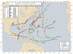
The 2001 Atlantic hurricane season was a fairly active Atlantic hurricane season that produced 17 tropical cyclones, 15 named storms, nine hurricanes, and four major hurricanes. The season officially lasted from June 1, 2001, to November 30, 2001, dates which by convention limit the period of each...
was above average in terms of activity, with 17 tropical cyclones, 15 named storms, 9 hurricanes, and 4 major hurricanes (hurricanes that are classified as Category 3 or higher). Although it officially began on June 1 and ended on November 30, the season managed to persist into December 6 due to continued activity from Hurricane Olga
Hurricane Olga (2001)
Hurricane Olga was a late season Category 1 Atlantic hurricane that formed during the 2001 Atlantic hurricane season. The fifteenth named storm, ninth and final hurricane of the 2001 season, Olga formed as a subtropical cyclone on November 24. After acquiring tropical characteristics later that...
, the season's final storm.
The season's most destructive storms were Tropical Storm Allison
Tropical Storm Allison
Tropical Storm Allison was a tropical storm that devastated southeast Texas in June of the 2001 Atlantic hurricane season. The first storm of the season, Allison lasted an unusually long period of time for a June storm, remaining tropical or subtropical for 15 days...
, Hurricane Iris
Hurricane Iris
Hurricane Iris was a Category 4 hurricane that devastated Belize in October 2001. It was the eleventh tropical cyclone, ninth named storm, fifth hurricane, and third major hurricane of the 2001 Atlantic hurricane season. It was the second strongest storm of the season behind Hurricane...
, and Hurricane Michelle
Hurricane Michelle
Hurricane Michelle was the thirteenth named storm and the strongest tropical cyclone of the 2001 Atlantic hurricane season. Michelle developed from a tropical wave that moved across the Atlantic, and formed into Tropical Depression Fifteen on the October 29. The depression slowly intensified as...
. Tropical Storm Allison caused catastrophic flooding in Texas, leading to 41 deaths and $5 billion (2001 USD; $6.1 billion 2008 USD) in damage, making it the costliest and deadliest storm of the season. Hurricane Iris was, in terms of wind speed
Maximum sustained wind
The maximum sustained winds associated with a tropical cyclone are a common indicator of the intensity of the storm. Within a mature tropical cyclone, they are found within the eyewall at a distance defined as the radius of maximum wind, or RMW. Unlike gusts, the value of these winds are...
, the strongest storm of the season. The storm made landfall in Belize as a Category 4 hurricane, causing $66.2 million (2001 USD; $80.6 million 2008 USD) in damage, and killing at least 31 people. Hurricane Michelle caused extensive damage in Cuba when it hit at Category 4 strength. In all, 17 people were killed, and Cuba alone experienced $1.8 billion (2001 USD; $2.2 billion 2008 USD) in damage. All three storms had their names retired by the World Meteorological Organization
World Meteorological Organization
The World Meteorological Organization is an intergovernmental organization with a membership of 189 Member States and Territories. It originated from the International Meteorological Organization , which was founded in 1873...
the following spring, and the names were replaced in the rotating name lists by Andrea, Ingrid, and Melissa, respectively. In turn, the replacement names saw their first use during the 2007 Atlantic hurricane season
2007 Atlantic hurricane season
The 2007 Atlantic hurricane season was an active Atlantic hurricane season that produced 17 tropical cyclones, 15 tropical storms, six hurricanes, and two major hurricanes. It officially started on June 1 and ended on November 30, dates which conventionally delimit the...
.
June
June 1- 12:00 a.m. EDTEastern Time ZoneThe Eastern Time Zone of the United States and Canada is a time zone that falls mostly along the east coast of North America. Its UTC time offset is −5 hrs during standard time and −4 hrs during daylight saving time...
(0400 UTC) – The 2001 Atlantic hurricane season2001 Atlantic hurricane seasonThe 2001 Atlantic hurricane season was a fairly active Atlantic hurricane season that produced 17 tropical cyclones, 15 named storms, nine hurricanes, and four major hurricanes. The season officially lasted from June 1, 2001, to November 30, 2001, dates which by convention limit the period of each...
officially begins.
June 5
- 7:00 a.m. CDT (1200 UTC) – Tropical Storm AllisonTropical Storm AllisonTropical Storm Allison was a tropical storm that devastated southeast Texas in June of the 2001 Atlantic hurricane season. The first storm of the season, Allison lasted an unusually long period of time for a June storm, remaining tropical or subtropical for 15 days...
forms about 140 miles (220 kilometres) south of GalvestonGalveston, TexasGalveston is a coastal city located on Galveston Island in the U.S. state of Texas. , the city had a total population of 47,743 within an area of...
, TexasTexasTexas is the second largest U.S. state by both area and population, and the largest state by area in the contiguous United States.The name, based on the Caddo word "Tejas" meaning "friends" or "allies", was applied by the Spanish to the Caddo themselves and to the region of their settlement in...
.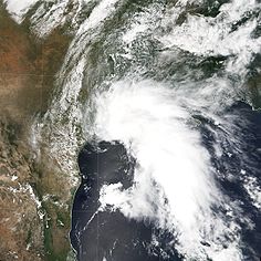
- 4:00 p.m. CDT (2100 UTC) – Tropical Storm Allison makes landfall near Freeport, TexasFreeport, TexasFreeport is a city in Brazoria County, Texas within the Houston–Sugar Land–Baytown metropolitan area and is situated in Southeast Texas. As of the 2000 U.S...
with 50 mph (85 km/h) winds.
June 6
- 1:00 a.m. CDT (0600 UTC) – Tropical Storm Allison weakens to a tropical depression.
June 9
- 7:00 p.m. CDT (0000 UTC June 10) – Tropical Depression Allison moves back over the Gulf of MexicoGulf of MexicoThe Gulf of Mexico is a partially landlocked ocean basin largely surrounded by the North American continent and the island of Cuba. It is bounded on the northeast, north and northwest by the Gulf Coast of the United States, on the southwest and south by Mexico, and on the southeast by Cuba. In...
near the same place it made landfall. - 7:00 p.m. CDT (0000 UTC June 10) – Tropical Depression Allison acquires some baroclinic characteristics, and is reclassified as a subtropical depression.
June 10
- 9:00 p.m. CDT (0200 UTC June 11) – Subtropical Depression Allison makes its final landfall near Morgan CityMorgan City, LouisianaMorgan City is a city in St. Martin and St. Mary parishes in the U.S. state of Louisiana. The population was 12,404 at the 2010 census....
, LouisianaLouisianaLouisiana is a state located in the southern region of the United States of America. Its capital is Baton Rouge and largest city is New Orleans. Louisiana is the only state in the U.S. with political subdivisions termed parishes, which are local governments equivalent to counties...
with 35 mph (55 km/h) winds.
June 11
- 1:00 a.m. CDT (0600 UTC) – Subtropical Depression Allison strengthens into a subtropical storm.
- 7:00 p.m. CDT (0000 UTC June 11) – Subtropical Storm Allison weakens back into a subtropical depression.
June 17
- 2:00 a.m. EDT (0600 UTC) – Subtropical Depression Allison exits the United StatesUnited StatesThe United States of America is a federal constitutional republic comprising fifty states and a federal district...
along the Delmarva PeninsulaDelmarva PeninsulaThe Delmarva Peninsula is a large peninsula on the East Coast of the United States, occupied by most of Delaware and portions of Maryland and Virginia...
. - 8:00 a.m. EDT (1200 UTC) – Subtropical Depression Allison regains subtropical storm strength.
- 8:00 p.m. EDT (0000 UTC June 18) – Subtropical Storm Allison degenerates into an extratropical low.
July
July 11- 2:00 p.m. ASTAtlantic Standard Time ZoneThe Atlantic Standard Time Zone is a geographical region that keeps time by subtracting four hours from either Coordinated Universal Time or Greenwich Mean Time , resulting in UTC-4 or GMT-4...
(1800 UTC) – Tropical Depression Two forms about 1,150 miles (1,840 km) east of the Windward IslandsWindward IslandsThe Windward Islands are the southern islands of the Lesser Antilles, within the West Indies.-Name and geography:The Windward Islands are called such because they were more windward to sailing ships arriving in the New World than the Leeward Islands, given that the prevailing trade winds in the...
.
July 12
- 8:00 p.m. AST (0000 UTC July 13) – Tropical Depression Two dissipates in the open Atlantic OceanAtlantic OceanThe Atlantic Ocean is the second-largest of the world's oceanic divisions. With a total area of about , it covers approximately 20% of the Earth's surface and about 26% of its water surface area...
.
August
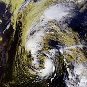
August 2.jpg)
- 8:00 a.m. EDT (1200 UTC) – Tropical Depression Three forms about 200 miles west of southern FloridaFloridaFlorida is a state in the southeastern United States, located on the nation's Atlantic and Gulf coasts. It is bordered to the west by the Gulf of Mexico, to the north by Alabama and Georgia and to the east by the Atlantic Ocean. With a population of 18,801,310 as measured by the 2010 census, it...
. - 2:00 p.m. EDT (1800 UTC) – Tropical Depression Three strengthens into Tropical Storm BarryTropical Storm Barry (2001)Tropical Storm Barry was a strong tropical storm that made landfall on the Florida Panhandle during August 2001. The third tropical cyclone and second named storm of the 2001 Atlantic hurricane season, Barry developed from a tropical wave that moved off the coast of Africa on July 24 and tracked...
.
August 3
- 7:00 p.m. CDT (0000 UTC August 4) – Tropical Storm Barry weakens to a tropical depression.
August 4
- 1:00 p.m. CDT (1800 UTC) – Tropical Depression Barry regains tropical storm strength.
August 6
- 12:00 a.m. CDT (0500 UTC) – Tropical Storm Barry makes landfall at Santa Rosa Beach, FloridaFloridaFlorida is a state in the southeastern United States, located on the nation's Atlantic and Gulf coasts. It is bordered to the west by the Gulf of Mexico, to the north by Alabama and Georgia and to the east by the Atlantic Ocean. With a population of 18,801,310 as measured by the 2010 census, it...
with 70 mph (110 km/h) winds. - 7:00 a.m. CDT (1200 UTC) – Tropical Storm Barry weakens back to a tropical depression.
August 7
- 1:00 a.m. CDT (0600 UTC) – Tropical Depression Barry degenerates into a remnant low near MemphisMemphis, TennesseeMemphis is a city in the southwestern corner of the U.S. state of Tennessee, and the county seat of Shelby County. The city is located on the 4th Chickasaw Bluff, south of the confluence of the Wolf and Mississippi rivers....
, TennesseeTennesseeTennessee is a U.S. state located in the Southeastern United States. It has a population of 6,346,105, making it the nation's 17th-largest state by population, and covers , making it the 36th-largest by total land area...
.
August 14
- 2:00 p.m. AST (1800 UTC) – Tropical Depression Four forms about 1,495 miles (2,390 km) east of the southern Windward Islands.
August 16
- 5:00 p.m. AST (2100 UTC) – Tropical Depression Four degenerates into an open wave.
August 17
- 10:00 a.m. EDT (1400 UTC) – After quickly passing through the Windward Islands, Tropical Storm ChantalTropical Storm Chantal (2001)Tropical Storm Chantal was an Atlantic tropical cyclone that moved across the Caribbean Sea in August 2001. Chantal developed from a tropical wave on August 14 in the tropical Atlantic Ocean. It tracked rapidly westward for much of its duration, and after degenerating into a tropical wave...
develops out of the remnants of Tropical Depression Four.
- 9:00 p.m. CDT (0200 UTC August 21) – Tropical Storm Chantal makes landfall near the MexicoMexicoThe United Mexican States , commonly known as Mexico , is a federal constitutional republic in North America. It is bordered on the north by the United States; on the south and west by the Pacific Ocean; on the southeast by Guatemala, Belize, and the Caribbean Sea; and on the east by the Gulf of...
/BelizeBelizeBelize is a constitutional monarchy and the northernmost country in Central America. Belize has a diverse society, comprising many cultures and languages. Even though Kriol and Spanish are spoken among the population, Belize is the only country in Central America where English is the official...
border with 70 mph (110 km/h) winds.
August 21
- 7:00 p.m. CDT (0000 UTC August 22) – Tropical Storm Chantal weakens to a tropical depression.
August 22
- 8:00 a.m. AST (1200 UTC) – Tropical Storm DeanTropical Storm Dean (2001)Tropical Storm Dean was a strong tropical storm that affected at least twelve islands along its path from the tropical Atlantic Ocean to east of Atlantic Canada. Dean developed from a tropical wave on August 22 over the Lesser Antilles, and was initially predicted to intensify further to reach...
forms over the U.S. Virgin Islands. - 1:00 p.m. CDT (1800 UTC) – Tropical Depression Chantal dissipates over southeastern Mexico.
August 23
- 8:00 a.m. AST (1200 UTC) – Tropical Storm Dean weakens to a tropical depression.
- 2:00 p.m. AST (1800 UTC) – Tropical Depression Dean degenerates into a tropical wave.
August 26
- 2:00 p.m. AST (1800 UTC) – After passing near BermudaBermudaBermuda is a British overseas territory in the North Atlantic Ocean. Located off the east coast of the United States, its nearest landmass is Cape Hatteras, North Carolina, about to the west-northwest. It is about south of Halifax, Nova Scotia, Canada, and northeast of Miami, Florida...
, Tropical Depression Dean redevelops out of its remnant low. - 8:00 p.m. AST (0000 UTC August 27) – Tropical Depression Dean regains tropical storm strength.
August 28
- 2:00 p.m. AST (1800 UTC) – Tropical Storm Dean becomes extratropical offshore NewfoundlandNewfoundland and LabradorNewfoundland and Labrador is the easternmost province of Canada. Situated in the country's Atlantic region, it incorporates the island of Newfoundland and mainland Labrador with a combined area of . As of April 2011, the province's estimated population is 508,400...
.
September

- 2:00 p.m. AST (1800 UTC) – Tropical Depression Six forms about 690 miles (1,100 km) west-southwest of the Cape Verde Islands.
September 2
- 2:00 a.m. AST (0600 UTC) – Tropical Depression Six strengthens into Tropical Storm Erin.
September 5
- 2:00 p.m. AST (1800 UTC) – Tropical Storm Erin degenerates into an area of disturbed weather.
September 6
- 2:00 p.m. AST (1800 UTC) – Tropical Depression Erin regenerates while about 600 miles (960 km) north-northeast of the northern Leeward IslandsLeeward IslandsThe Leeward Islands are a group of islands in the West Indies. They are the northern islands of the Lesser Antilles chain. As a group they start east of Puerto Rico and reach southward to Dominica. They are situated where the northeastern Caribbean Sea meets the western Atlantic Ocean...
.
September 7
- 8:00 a.m. AST (1200 UTC) – Tropical Depression Seven forms about 415 miles (660 km) southwest of the Cape Verde Islands.
- 2:00 p.m. AST (1800 UTC) – Tropical Depression Erin regains tropical storm status.
September 8
- 2:00 p.m. AST (1800 UTC) – Tropical Depression Seven degenerates into an open wave.
- 8:00 p.m. AST (0000 UTC September 9) – Tropical Storm Erin is upgraded to Hurricane ErinHurricane Erin (2001)Hurricane Erin was the longest-lived hurricane in the 2001 Atlantic hurricane season. The sixth tropical depression, fifth tropical storm, and first hurricane, Erin developed from a tropical wave on September 1. After strengthening to a 60 mph tropical storm as it moved to the west-northwest,...
, becoming the first hurricane of the season.
September 9
- 2:00 a.m. AST (0600 UTC) – Hurricane Erin reaches Category 2 intensity.
- 2:00 p.m. AST (1800 UTC) – Hurricane Erin reaches Category 3 intensity, becoming the season's first major hurricane.
- 2:00 a.m. AST (0600 UTC) – Tropical Depression Seven regenerates.
- 2:00 p.m. AST (1800 UTC) – Hurricane Erin weakens to a Category 2 hurricane.
- 8:00 p.m. AST (0000 UTC September 11) – Hurricane Erin weakens to a Category 1 hurricane.
September 11
- 8:00 a.m. AST (1200 UTC) – Tropical Depression Seven strengthens into Tropical Storm Felix.
- 2:00 p.m. EDT (1800 UTC) – Tropical Depression Eight forms in the southeastern Gulf of Mexico.
September 12
- 8:00 p.m. AST (0000 UTC September 13) – Tropical Storm Felix becomes a hurricane.
September 13
- 8:00 a.m. AST (1200 UTC) – Hurricane Felix reaches Category 2 intensity.
- 8:00 a.m. EDT (1200 UTC) – Tropical Depression Eight strengthens into Tropical Storm Gabrielle.
- 8:00 p.m. AST (0000 UTC September 14) – Hurricane Felix reaches Category 3 intensity.
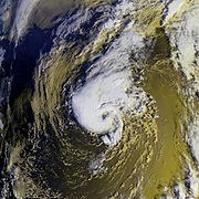
September 14
.jpg)
- 8:00 a.m. EDT (1200 UTC) – Tropical Storm Gabrielle makes landfall near VeniceVenice, FloridaVenice is a city in Sarasota County, Florida, United States. According to the U.S. Census Bureau's 2007 estimates, the city had a population of 21,015. It is noted for its large snowbird population. Its newspaper is the Venice Gondolier Sun...
, Florida with 70 mph (110 km/h) winds. - 8:00 a.m. AST (1200 UTC) – Hurricane Felix weakens to a Category 2 hurricane.
- 8:00 p.m. AST (0000 UTC September 15) – Hurricane Erin weakens to a tropical storm.
September 15
- 2:00 a.m. AST (0600 UTC) – Tropical Storm Erin becomes extratropical.
- 2:00 a.m. EDT (0600 UTC) – Tropical Storm Gabrielle exits Florida, and enters the Atlantic Ocean.
September 16
- 2:00 a.m. AST (0600 UTC) – Hurricane Felix weakens to a Category 1 hurricane.
- 8:00 p.m. EDT (0000 UTC September 17) – Tropical Storm Gabrielle strengthens into Hurricane GabrielleHurricane Gabrielle (2001)Hurricane Gabrielle was a moderate category 1 hurricane which made landfall near Venice, Florida as a strong tropical storm. The eighth tropical cyclone, seventh named storm, and third hurricane of the 2001 Atlantic hurricane season, Gabrielle developed from a non-tropical low-to mid-level trough...
.
September 17
- 8:00 a.m. AST (1200 UTC) – Hurricane Felix weakens to a tropical storm.
- 8:00 p.m. AST (0000 UTC September 18) – Hurricane Gabrielle weakens to a tropical storm.
September 18
- 2:00 p.m. AST (1800 UTC) – Tropical Storm Felix weakens to a tropical depression.
- 8:00 p.m. AST (0000 UTC September 19) – Tropical Depression Felix dissipates about 400 miles (640 km) southwest of the AzoresAzoresThe Archipelago of the Azores is composed of nine volcanic islands situated in the middle of the North Atlantic Ocean, and is located about west from Lisbon and about east from the east coast of North America. The islands, and their economic exclusion zone, form the Autonomous Region of the...
.
September 19
- 2:00 a.m. AST (0600 UTC) – Tropical Storm Gabrielle becomes extratropical.
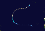
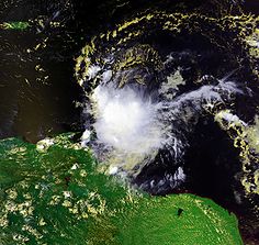
- 1:00 p.m. CDT (1800 UTC) – Tropical Depression Nine forms about 60 miles (90 km) north-northwest of San Andres Island.
- 7:00 p.m. CDT (0000 UTC September 20) – Tropical Depression Nine makes landfall near Puerto CabezasPuerto CabezasPuerto Cabezas is a municipality in, and capital of, the North Atlantic Coast department of Nicaragua....
, NicaraguaNicaraguaNicaragua is the largest country in the Central American American isthmus, bordered by Honduras to the north and Costa Rica to the south. The country is situated between 11 and 14 degrees north of the Equator in the Northern Hemisphere, which places it entirely within the tropics. The Pacific Ocean...
with 35 mph (55 km/h) winds.
September 20
- 7:00 a.m. CDT (1200 UTC) – Tropical Depression Nine dissipates near the HondurasHondurasHonduras is a republic in Central America. It was previously known as Spanish Honduras to differentiate it from British Honduras, which became the modern-day state of Belize...
/Nicaragua border.

- 8:00 a.m. AST (1200 UTC) – Tropical Depression Ten forms about 490 miles (780 km) south of Bermuda.
September 22
- 8:00 a.m. AST (1200 UTC) – Tropical Depression Ten strengthens into Tropical Storm Humberto.
September 23
- 8:00 a.m. EDT (1200 UTC) – Tropical Storm Humberto becomes a hurricane.
- 8:00 p.m. EDT (0000 UTC September 24) – Hurricane Humberto reaches Category 2 intensity.
September 24
- 2:00 a.m. AST (0600 UTC) – Hurricane Humberto weakens to a Category 1 hurricane.
September 26
- 8:00 a.m. AST (1200 UTC) – Hurricane Humberto regains Category 2 intensity.
- 2:00 p.m. AST (1800 UTC) – Hurricane Humberto weakens back into a Category 1 hurricane.
September 27
- 8:00 a.m. AST (1200 UTC) – Hurricane Humberto weakens to a tropical storm.
- 2:00 p.m. AST (1800 UTC) – Tropical Storm Humberto degenerates into an open trough.
October
October 4
- 8:00 a.m. AST (1200 UTC) – Tropical Depression Eleven forms about 100 miles (155 km) southeast of BarbadosBarbadosBarbados is an island country in the Lesser Antilles. It is in length and as much as in width, amounting to . It is situated in the western area of the North Atlantic and 100 kilometres east of the Windward Islands and the Caribbean Sea; therein, it is about east of the islands of Saint...
.
October 5
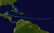
- 8:00 a.m. AST (1200 UTC) – Tropical Storm Eleven strengthens into Tropical Storm Iris.
October 6
- 8:00 a.m. AST (1200 UTC) – Tropical Depression Twelve forms about 620 miles (990 km) east-southeast of Barbados.
- 2:00 p.m. EDT (1800 UTC) – Tropical Storm Iris strengthens into Hurricane IrisHurricane IrisHurricane Iris was a Category 4 hurricane that devastated Belize in October 2001. It was the eleventh tropical cyclone, ninth named storm, fifth hurricane, and third major hurricane of the 2001 Atlantic hurricane season. It was the second strongest storm of the season behind Hurricane...
. - 8:00 p.m. AST (0000 UTC October 7) – Tropical Depression Twelve strengthens into Tropical Storm JerryTropical Storm Jerry (2001)Tropical Storm Jerry was a short-lived tropical storm that formed in the latter half of the 2001 Atlantic hurricane season. Forming as a tropical depression from a tropical wave on October 6 near Barbados, Jerry intensified into a tropical storm early the following day on October 7 while initially...
.
October 7
- 11:00 p.m. AST (0300 UTC October 8) – Tropical Storm Jerry passes near St. VincentSaint Vincent (island)Saint Vincent is a volcanic island in the Caribbean. It is the largest island of the chain called Saint Vincent and the Grenadines. It is located in the Caribbean Sea, between Saint Lucia and Grenada. It is composed of partially submerged volcanic mountains...
with 50 mph (85 km/h) winds, but does not make landfall.
October 8
- 2:00 a.m. EDT (0600 UTC) – Hurricane Iris reaches Category 2 intensity.
- 8:00 a.m. EDT (1200 UTC) – Hurricane Iris rapidly intensifies to a Category 4 hurricane.
- 2:00 p.m. AST (1800 UTC) – Tropical Storm Jerry weakens to a tropical depression.
- 7:00 p.m. CDT (0000 UTC October 9) – Hurricane Iris's winds reach 145 mph, making it the most powerful storm of the season in terms of wind.
- 8:00 p.m. AST (0000 UTC October 9) – Tropical Depression Jerry dissipates.
- 9:00 p.m. CDT (0200 UTC October 9) – Hurricane Iris makes landfall near Monkey River TownMonkey River TownMonkey River Town is a village in the north of the Toledo District of the Central American nation of Belize. It is on the Caribbean Sea on the southern shore of the mouth of Belize's Monkey River...
, Belize with 145 mph (230 km/h) winds.
- 1:00 a.m. CDT (0600 UTC) – Hurricane Iris rapidly weakens to a tropical storm.
- 7:00 a.m. CDT (1200 UTC) – Tropical Storm Iris weakens to a tropical depression.
- 1:00 p.m. CDT (1800 UTC) – Tropical Depression Iris dissipates as it crosses the Mexico/GuatemalaGuatemalaGuatemala is a country in Central America bordered by Mexico to the north and west, the Pacific Ocean to the southwest, Belize to the northeast, the Caribbean to the east, and Honduras and El Salvador to the southeast...
border.
October 11
- 8:00 p.m. AST (0000 UTC October 12) – Subtropical Storm One develops from an extratropical low about 35 miles (55 km) south of Bermuda.
October 13
- 2:00 a.m. AST (0600 UTC) – Subtropical Storm One acquires tropical characteristics, and is reclassified as Tropical Storm Karen.
- 2:00 p.m. AST (1800 UTC) – Tropical Storm Karen strengthens into Hurricane KarenHurricane Karen (2001)Hurricane Karen was a hurricane of non-tropical origin that formed in October of the 2001 Atlantic hurricane season. It developed out of the interaction between a cold front and an upper level trough on October 10 located to the south of Bermuda, and quickly strengthened as an extratropical storm....
.
October 14
- 8:00 a.m. AST (1200 UTC) – Hurricane Karen weakens to a tropical storm.
October 15
- 8:00 a.m. AST (1200 UTC) – Tropical Storm Karen makes landfall near Western Head, Nova ScotiaNova ScotiaNova Scotia is one of Canada's three Maritime provinces and is the most populous province in Atlantic Canada. The name of the province is Latin for "New Scotland," but "Nova Scotia" is the recognized, English-language name of the province. The provincial capital is Halifax. Nova Scotia is the...
with 45 mph (75 km/h) winds. - 2:00 p.m. AST (1800 UTC) – Tropical Storm Karen degenerates into an extratropical low.
October 27
- 8:00 a.m. AST (1200 UTC) – Tropical Depression Fourteen forms about 860 miles (1,380 km) south-southwest of the Azores.
October 29
- 1:00 p.m. EST (1800 UTC) – Tropical Depression Fifteen forms over the Nicaragua coastline between Puerto CabezasPuerto CabezasPuerto Cabezas is a municipality in, and capital of, the North Atlantic Coast department of Nicaragua....
and BluefieldsBluefieldsBluefields is the capital of the municipality of the same name, and of Región Autónoma del Atlántico Sur in Nicaragua. It was also capital of the former Zelaya Department, which was divided into North and South Atlantic Autonomous Regions...
. - 8:00 p.m. AST (0000 UTC October 30) – Tropical Depression Fourteen strengthens into Tropical Storm Lorenzo.
October 31
- 7:00 a.m. EST (1200 UTC) – Tropical Depression Fifteen leaves Nicaragua and enters the Gulf of HondurasGulf of HondurasThe Gulf or Bay of Honduras is a large inlet of the Caribbean Sea, indenting the coasts of Belize, Guatemala, and Honduras. From north to south, it runs for approximately 200 km from Dangriga, Belize, to La Ceiba, Honduras....
. - 8:00 a.m. AST (1200 UTC) – Tropical Storm Lorenzo dissipates as it merges with a frontal zone.
- 7:00 p.m. EST (0000 UTC November 1) – Tropical Depression Fifteen strengthens into Tropical Storm Michelle.
November
November 2- 7:00 a.m. EST (1200 UTC) – Tropical Storm Michelle strengthens into Hurricane MichelleHurricane MichelleHurricane Michelle was the thirteenth named storm and the strongest tropical cyclone of the 2001 Atlantic hurricane season. Michelle developed from a tropical wave that moved across the Atlantic, and formed into Tropical Depression Fifteen on the October 29. The depression slowly intensified as...
. - 7:00 p.m. EST (0000 UTC November 3) – Hurricane Michelle reaches Category 2 intensity.
November 3
- 1:00 a.m. EST (0600 UTC) – Hurricane Michelle reaches Category 3 intensity.
- 7:00 a.m. EST (1200 UTC) – Hurricane Michelle reaches Category 4 intensity.
- 1:00 p.m. EST (1800 UTC) – Hurricane Michelle weakens to a Category 3 hurricane.

- 4:00 p.m. EST (2100 UTC) – Hurricane Michelle's pressure drops to 933 millibars, not only making it the most intense storm of the season in terms of pressure, but in the same terms tying it with Hurricane LennyHurricane LennyHurricane Lenny was the strongest November Atlantic hurricane on record. It was the twelfth tropical storm, eighth hurricane, and record-breaking fifth Category 4 hurricane in the 1999 Atlantic hurricane season. Lenny formed on November 13 in the western Caribbean Sea, and maintained an...
for the most powerful November Atlantic hurricane on record. - 7:00 p.m. EST (0000 UTC November 4) – Hurricane Michelle regains Category 4 intensity.
- 8:00 p.m. AST (0000 UTC November 4) – Subtropical Storm Two forms about 890 miles (1,425 km) south of Cape RaceCape RaceCape Race is a point of land located at the southeastern tip of the Avalon Peninsula on the island of Newfoundland, Canada. Its name is thought to come from the original Portuguese name for this cape, "Raso", or "bare"...
, NewfoundlandNewfoundland and LabradorNewfoundland and Labrador is the easternmost province of Canada. Situated in the country's Atlantic region, it incorporates the island of Newfoundland and mainland Labrador with a combined area of . As of April 2011, the province's estimated population is 508,400...
.
November 4
- 1:00 p.m. EST (1800 UTC) – Hurricane Michelle makes its first landfall at Cayo LargoCayo Largo del SurCayo Largo del Sur, also known simply as Cayo Largo, cayo largo means largo island, is a small resort island belonging to Cuba, in the Caribbean Sea no more than long and wide...
, CubaCubaThe Republic of Cuba is an island nation in the Caribbean. The nation of Cuba consists of the main island of Cuba, the Isla de la Juventud, and several archipelagos. Havana is the largest city in Cuba and the country's capital. Santiago de Cuba is the second largest city...
with 140 mph (220 km/h) winds. - 6:00 p.m. EST (2300 UTC) – Hurricane Michelle makes its second landfall at Bay of PigsBay of PigsThe Bay of Pigs is an inlet of the Gulf of Cazones on the southern coast of Cuba. By 1910, it was included in Santa Clara Province, and then instead to Las Villas Province by 1961, but in 1976, it was re-assigned to Matanzas Province, when the original six provinces of Cuba were re-organized into...
, Cuba with 135 mph (210 km/h) winds. - 7:00 p.m. EST (0000 UTC November 5) – Hurricane Michelle weakens back into a Category 3 hurricane.
November 5
- 1:00 a.m. EST (0600 UTC) – Hurricane Michelle quickly weakens to a Category 1 hurricane.
- 7:00 a.m. EST (1200 UTC) – Hurricane Michelle makes its third landfall on Andros Island with 90 mph (145 km/h) winds.
- 8:00 a.m. AST (1200 UTC) – Subtropical Storm Two reaches hurricane strength while acquiring tropical characteristics, and is reclassified as Hurricane NoelHurricane Noel (2001)The November 2001 Atlantic Canada storm complex was a powerful coastal storm that included the remnants of Atlantic hurricanes Michelle and Noel. The low intensified as it moved westward into Atlantic Canada on November 6, reaching pressures as low as 946 mbar. The storm turned to the...
. - 1:00 p.m. EST (1800 UTC) – Hurricane Michelle makes its fourth and final landfall on Eleuthera Island with 85 mph (140 km/h) winds.
- 7:00 p.m. EST (0000 UTC November 6) – Hurricane Michelle becomes extratropical.
- 8:00 p.m. AST (0000 UTC November 6) – Hurricane Noel weakens to a tropical storm.
November 6
- 8:00 a.m. AST (1200 UTC) – Tropical Storm Noel becomes extratropical.
- 8:00 p.m. AST (0000 UTC November 24) – Subtropical Storm Three forms from an extratropical low about 900 miles (1,435 km) east-southeast of Bermuda.
November 24
- 8:00 a.m. AST (1200 UTC) – Subtropical Storm Three acquires tropical characteristics, and is reclassified as Tropical Storm Olga.
November 26
- 8:00 a.m. AST (1200 UTC) – Tropical Storm Olga strengthens into Hurricane OlgaHurricane Olga (2001)Hurricane Olga was a late season Category 1 Atlantic hurricane that formed during the 2001 Atlantic hurricane season. The fifteenth named storm, ninth and final hurricane of the 2001 season, Olga formed as a subtropical cyclone on November 24. After acquiring tropical characteristics later that...
.
November 29
- 2:00 a.m. AST (0600 UTC) – Hurricane Olga weakens to a tropical storm.
November 30
- 8:00 a.m. AST (1200 UTC) – Tropical Storm Olga weakens to a tropical depression.
- 11:59 p.m. AST (0359 UTC December 1) – The 2001 Atlantic hurricane season officially ends with Tropical Depression Olga still active.
December
December 1
- 7:00 p.m. EST (0000 UTC December 2) – Tropical Depression Olga regains tropical storm strength.
December 3
- 7:00 p.m. EST (0000 UTC December 4) – Tropical Storm Olga weakens back into a tropical depression.
December 4
- 7:00 p.m. EST (0000 UTC December 5) – Tropical Depression Olga dissipates over the Atlantic Ocean, marking the end of the 2001 Atlantic hurricane season.