

Subantarctic
Encyclopedia
Physiographic regions of the world
The physiographic regions of the world are a means of defining the Earth's landforms into distinct regions based upon classic 1916 three-tiered approach defining divisions, provinces, and sections...
in the southern hemisphere
Southern Hemisphere
The Southern Hemisphere is the part of Earth that lies south of the equator. The word hemisphere literally means 'half ball' or "half sphere"...
, located immediately north of the Antarctic
Antarctic
The Antarctic is the region around the Earth's South Pole, opposite the Arctic region around the North Pole. The Antarctic comprises the continent of Antarctica and the ice shelves, waters and island territories in the Southern Ocean situated south of the Antarctic Convergence...
region. This translates roughly to a latitude
Latitude
In geography, the latitude of a location on the Earth is the angular distance of that location south or north of the Equator. The latitude is an angle, and is usually measured in degrees . The equator has a latitude of 0°, the North pole has a latitude of 90° north , and the South pole has a...
of between 46°
46th parallel south
The 46th parallel south is a circle of latitude that is 46 degrees south of the Earth's equatorial plane. It crosses the Atlantic Ocean, the Indian Ocean, Australasia, the Pacific Ocean and South America....
– 60°
60th parallel south
The 60th parallel south is a circle of latitude that is 60 degrees south of the Earth's equatorial plane. No land lies on the parallel—it crosses nothing but ocean...
south of the Equator
Equator
An equator is the intersection of a sphere's surface with the plane perpendicular to the sphere's axis of rotation and containing the sphere's center of mass....
. The subantarctic region includes many island
Island
An island or isle is any piece of sub-continental land that is surrounded by water. Very small islands such as emergent land features on atolls can be called islets, cays or keys. An island in a river or lake may be called an eyot , or holm...
s in the southern parts of the Indian Ocean
Indian Ocean
The Indian Ocean is the third largest of the world's oceanic divisions, covering approximately 20% of the water on the Earth's surface. It is bounded on the north by the Indian Subcontinent and Arabian Peninsula ; on the west by eastern Africa; on the east by Indochina, the Sunda Islands, and...
, Atlantic Ocean
Atlantic Ocean
The Atlantic Ocean is the second-largest of the world's oceanic divisions. With a total area of about , it covers approximately 20% of the Earth's surface and about 26% of its water surface area...
and Pacific Ocean
Pacific Ocean
The Pacific Ocean is the largest of the Earth's oceanic divisions. It extends from the Arctic in the north to the Southern Ocean in the south, bounded by Asia and Australia in the west, and the Americas in the east.At 165.2 million square kilometres in area, this largest division of the World...
, especially those situated north of the Antarctic Convergence
Antarctic Convergence
The Antarctic Convergence is a curve continuously encircling Antarctica where cold, northward-flowing Antarctic waters meet the relatively warmer waters of the subantarctic. Antarctic waters predominantly sink beneath subantarctic waters, while associated zones of mixing and upwelling create a zone...
. Subantarctic glaciers are, by definition, located on islands within the subantarctic region. All glacier
Glacier
A glacier is a large persistent body of ice that forms where the accumulation of snow exceeds its ablation over many years, often centuries. At least 0.1 km² in area and 50 m thick, but often much larger, a glacier slowly deforms and flows due to stresses induced by its weight...
s located on the continent
Continent
A continent is one of several very large landmasses on Earth. They are generally identified by convention rather than any strict criteria, with seven regions commonly regarded as continents—they are : Asia, Africa, North America, South America, Antarctica, Europe, and Australia.Plate tectonics is...
of Antarctica are by definition considered to be antarctic glaciers.
Geography
The subantarctic region comprises two geographic zones and three distinct frontWeather front
A weather front is a boundary separating two masses of air of different densities, and is the principal cause of meteorological phenomena. In surface weather analyses, fronts are depicted using various colored lines and symbols, depending on the type of front...
s. The northernmost boundary of the subantarctic region is the rather ill-defined Subtropical Front
Subtropical Front
Subtropical Front is a term used in Oceanography to describe a boundary between water systems based on temperature and salinity.- Northern Subtropical Front :A subtropical front in the Pacific Ocean lying between 25 and 30 degrees north latitude....
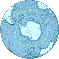
(STF), also referred to as the Subtropical Convergence. To the south of the STF is a geographic zone, the Subantarctic Zone (SAZ). South of the SAZ is the Subantarctic Front (SAF). South of the SAF is another marine zone, called the Polar Frontal Zone (PFZ). The SAZ and the PFZ together form the subantarctic region. The southernmost boundary of the PFZ (and hence, the southern border of the subantarctic region) is the Antarctic Convergence, located approximately 200 kilometers south of the Antarctic Polar Front
Polar front
In meteorology, the polar front is the boundary between the polar cell and the Ferrel cell in each hemisphere. At this boundary a sharp gradient in temperature occurs between these two air masses, each at very different temperatures....
(APF).
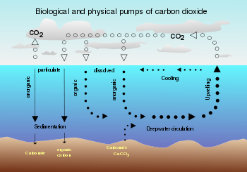
Influence of the Antarctic Circumpolar Current and thermohaline circulation
48th parallel south
The 48th parallel south is a circle of latitude that is 48 degrees south of the Earth's equatorial plane. It crosses the Atlantic Ocean, the Indian Ocean, the Pacific Ocean and South America....
and 58°S
58th parallel south
The 58th parallel south is a circle of latitude that is 58 degrees south of the Earth's equatorial plane. No land lies on the parallel—it crosses nothing but ocean....
in the Indian and Pacific Ocean and between 42°S
42nd parallel south
The 42nd parallel south is a circle of latitude that is 42 degrees south of the Earth's equatorial plane. It crosses the Atlantic Ocean, the Indian Ocean, Australasia, the Pacific Ocean and South America....
and 48°S in the Atlantic Ocean, defines the northern boundary of the Antarctic Circumpolar Current
Antarctic Circumpolar Current
The Antarctic Circumpolar Current is an ocean current that flows from west to east around Antarctica. An alternative name for the ACC is the West Wind Drift. The ACC is the dominant circulation feature of the Southern Ocean and, at approximately 125 Sverdrups, the largest ocean current...
(or ACC). The ACC is the most important ocean current
Ocean current
An ocean current is a continuous, directed movement of ocean water generated by the forces acting upon this mean flow, such as breaking waves, wind, Coriolis effect, cabbeling, temperature and salinity differences and tides caused by the gravitational pull of the Moon and the Sun...
in the Southern Ocean
Southern Ocean
The Southern Ocean comprises the southernmost waters of the World Ocean, generally taken to be south of 60°S latitude and encircling Antarctica. It is usually regarded as the fourth-largest of the five principal oceanic divisions...
, and the only current that flows completely around the Earth. Flowing eastward through the southern portions of the Atlantic, Indian, and Pacific Oceans, the ACC links these three otherwise separate oceanic basin
Oceanic basin
Hydrologically, an oceanic basin may be anywhere on Earth that is covered by seawater, but geologically ocean basins are large geologic basins that are below sea level...
s. Extending from the sea surface to depths of 2000–4000 meters, and with a width of as great as 2000 kilometers, the ACC transports more water than any other ocean current. The ACC carries up to 150 Sverdrup
Sverdrup
The sverdrup, named in honour of the pioneering oceanographer Harald Sverdrup, is a unit of measure of volume transport. It is used almost exclusively in oceanography, to measure the transport of ocean currents. Its symbol is Sv. Note that the sverdrup is not an SI unit, and that its symbol...
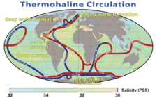
s (150 million cubic meters per second), equivalent to 150 times the volume of water flowing in all the world's rivers. The ACC and the global thermohaline circulation
Thermohaline circulation
The term thermohaline circulation refers to a part of the large-scale ocean circulation that is driven by global density gradients created by surface heat and freshwater fluxes....
strongly influence regional and global climate
Climate
Climate encompasses the statistics of temperature, humidity, atmospheric pressure, wind, rainfall, atmospheric particle count and other meteorological elemental measurements in a given region over long periods...
as well as underwater biodiversity
Biodiversity
Biodiversity is the degree of variation of life forms within a given ecosystem, biome, or an entire planet. Biodiversity is a measure of the health of ecosystems. Biodiversity is in part a function of climate. In terrestrial habitats, tropical regions are typically rich whereas polar regions...
.
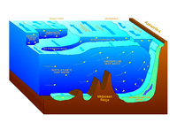
Another factor that contributes to the climate of the subantarctic region, though to a much lesser extent than the thermohaline circulation, is the formation of Antarctic Bottom Water
Antarctic Bottom Water
The 'Antarctic Bottom Water' is a type of water mass in the seas surrounding Antarctica with temperatures ranging from 0 to -0.8◦ C, salinities from 34.6 to 34.7 psu, and a density near 27.88...
(ABW) by halothermal dynamics
Halothermal circulation
The term halothermal circulation refers to the part of the large-scale ocean circulation that is driven by global density gradients created by surface heat and evaporation....
. The halothermal circulation is that portion of the global ocean circulation that is driven by global density gradient
Density Gradient
Density gradient is a spatial variation in density over an area. The term is used in the natural sciences to describe varying density of matter, but can apply to any quantity whose density can be measured...
s created by surface heat and evaporation
Evaporation
Evaporation is a type of vaporization of a liquid that occurs only on the surface of a liquid. The other type of vaporization is boiling, which, instead, occurs on the entire mass of the liquid....
.
Definition of subantarctic: political versus scientific
Water mass
An oceanographic water mass is an identifiable body of water with a common formation history which has physical properties distinct from surrounding water...
es converge in the immediate vicinity of the APF or Antarctic Convergence (in particular the Subantarctic Surface Water
Subantarctic Mode Water
Subantarctic mode water is an important water mass in the Earth's oceans. It is formed near the Subantarctic Front on the northern flank of the Antarctic Circumpolar Current...
(Subantarctic Mode Water or SAMW), Antarctic Surface Water, and the Antarctic Intermediate Water
Antarctic Intermediate Water
Antarctic Intermediate Water is a cold, relatively low salinity water mass found mostly at intermediate depths in the Southern Ocean. The AAIW is formed at the ocean surface in the Antarctic Convergence zone or more commonly called the Antarctic Polar Front zone...
). This convergence creates a unique environment, noted for its very high marine productivity
Primary production
400px|thumb|Global oceanic and terrestrial photoautotroph abundance, from September [[1997]] to August 2000. As an estimate of autotroph biomass, it is only a rough indicator of primary production potential, and not an actual estimate of it...
, especially for Antarctic krill
Antarctic krill
Antarctic krill, Euphausia superba, is a species of krill found in the Antarctic waters of the Southern Ocean. It is a shrimp-like crustacean that lives in large schools, called swarms, sometimes reaching densities of 10,000–30,000 individual animals per cubic metre...
. Because of this, all lands and waters situated south of the Antarctic Convergence are considered to belong to the Antarctic from a climatological
Climatology
Climatology is the study of climate, scientifically defined as weather conditions averaged over a period of time, and is a branch of the atmospheric sciences...
, biological
Biology
Biology is a natural science concerned with the study of life and living organisms, including their structure, function, growth, origin, evolution, distribution, and taxonomy. Biology is a vast subject containing many subdivisions, topics, and disciplines...
and hydrological
Hydrology
Hydrology is the study of the movement, distribution, and quality of water on Earth and other planets, including the hydrologic cycle, water resources and environmental watershed sustainability...
standpoint. However, the text of the Antarctic Treaty
Antarctic Treaty System
The Antarctic Treaty and related agreements, collectively called the Antarctic Treaty System or ATS, regulate international relations with respect to Antarctica, Earth's only continent without a native human population. For the purposes of the treaty system, Antarctica is defined as all of the land...
, article VI ("Area covered by Treaty") states: "The provisions of the present Treaty shall apply to the area south of 60º South latitude
60th parallel south
The 60th parallel south is a circle of latitude that is 60 degrees south of the Earth's equatorial plane. No land lies on the parallel—it crosses nothing but ocean...
". Therefore, Antarctica is defined from a political
Politics
Politics is a process by which groups of people make collective decisions. The term is generally applied to the art or science of running governmental or state affairs, including behavior within civil governments, but also applies to institutions, fields, and special interest groups such as the...
standpoint as all land and ice shelves
Ice shelf
An ice shelf is a thick, floating platform of ice that forms where a glacier or ice sheet flows down to a coastline and onto the ocean surface. Ice shelves are only found in Antarctica, Greenland and Canada. The boundary between the floating ice shelf and the grounded ice that feeds it is called...
south of 60°S latitude.
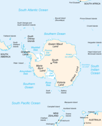
Subantarctic islands
Tristan da Cunha
Tristan da Cunha is a remote volcanic group of islands in the south Atlantic Ocean and the main island of that group. It is the most remote inhabited archipelago in the world, lying from the nearest land, South Africa, and from South America...
, Île Amsterdam
Île Amsterdam
New Amsterdam, Amsterdam Island, or Île Amsterdam is a French island in the Indian Ocean located at . It is part of the French Southern and Antarctic Lands.- History :...
, Île Saint-Paul
Île Saint-Paul
Île Saint-Paul is an island forming part of the French Southern and Antarctic Lands in the Indian Ocean, with an area of . It is located about southwest of the larger Île Amsterdam, and south of Réunion...
, and Gough Island
Gough Island
Gough Island , also known historically as Gonçalo Álvares or Diego Alvarez, is a volcanic island in the South Atlantic Ocean. It is a dependency of Tristan da Cunha and part of the British overseas territory of Saint Helena, Ascension and Tristan da Cunha...
are all isolated volcanic islands
High island
In geology , a high island is an island of volcanic origin. The term can be used to distinguish such islands from low islands, whose origin is due to sedimentation or uplifting of coral reefs.-Definition and origin:...
situated at between 37°
37th parallel south
The 37th parallel south is a circle of latitude that is 37 degrees south of the Earth's equatorial plane. It crosses the Atlantic Ocean, the Indian Ocean, Australasia, the Pacific Ocean and South America....
- 40°
40th parallel south
The 40th parallel south is a circle of latitude that is 40 degrees south of the Earth's equatorial plane. It crosses the Atlantic Ocean, the Indian Ocean, Australasia, the Pacific Ocean and South America....
south of the equator, just south of the southern Horse latitudes
Horse latitudes
Horse Latitudes or Subtropical High are subtropical latitudes between 30 and 35 degrees both north and south. This region, under a ridge of high pressure called the subtropical high, is an area which receives little precipitation and has variable winds mixed with calm.The consistently warm, dry...
. Because they are located far to the north of the Antarctic Convergence and have a relatively temperate climate, they are not typically considered to be subantarctic islands.
At between 46°
46th parallel south
The 46th parallel south is a circle of latitude that is 46 degrees south of the Earth's equatorial plane. It crosses the Atlantic Ocean, the Indian Ocean, Australasia, the Pacific Ocean and South America....
– 50°
50th parallel south
The 50th parallel south is a circle of latitude that is 50 degrees south of the Earth's equatorial plane. It crosses the Atlantic Ocean, the Indian Ocean, the Pacific Ocean and South America....
south of the equator, in the region often referred to as the Roaring Forties
Roaring Forties
The Roaring Forties is the name given to strong westerly winds found in the Southern Hemisphere, generally between the latitudes of 40 and 49 degrees. Air displaced from the Equator towards the South Pole, which travels close to the surface between the latitudes of 30 and 60 degrees south, combines...
, are the Crozet Islands
Crozet Islands
The Crozet Islands are a sub-antarctic archipelago of small islands in the southern Indian Ocean. They form one of the five administrative districts of the French Southern and Antarctic Lands.-Geography:...
, Prince Edward Islands
Prince Edward Islands
The Prince Edward Islands are two small islands in the sub-antarctic Indian Ocean that are part of South Africa. The islands, named Marion Island and Prince Edward Island, are located at ....
, Bounty Islands
Bounty Islands
The Bounty Islands at are a small group of 13 granite islets and numerous rocks, with a combined area of , in the south Pacific Ocean that are territorially part of New Zealand. They are located between 47°44'35" and 47°46'10" S, and 179°01' and 179°04'20" E, southeast of the South Island of New...
, Snares Islands, Kerguelen Islands
Kerguelen Islands
The Kerguelen Islands , also known as the Desolation Islands, are a group of islands in the southern Indian Ocean constituting the emerged part of the otherwise submerged Kerguelen Plateau. The islands, along with Adélie Land, the Crozet Islands and the Amsterdam and Saint Paul Islands are part of...
, Antipodes Islands
Antipodes Islands
The Antipodes Islands are inhospitable volcanic islands to the south of—and territorially part of—New Zealand...
, and Auckland Islands
Auckland Islands
The Auckland Islands are an archipelago of the New Zealand Sub-Antarctic Islands and include Auckland Island, Adams Island, Enderby Island, Disappointment Island, Ewing Island, Rose Island, Dundas Island and Green Island, with a combined area of...
. These islands, all located approximately on the Antarctic Convergence (roughly the northern boundary of the subantarctic region), are properly considered to be subantarctic islands.
At between 51°
51st parallel south
The 51st parallel south is a circle of latitude that is 51 degrees south of the Earth's equatorial plane. It crosses the Atlantic Ocean, the Indian Ocean, the Pacific Ocean and South America....
– 56°
56th parallel south
The 56th parallel south is a circle of latitude that is 56 degrees south of the Earth's equatorial plane. No land lies on the parallel—it crosses nothing but ocean.Starting at the Prime Meridian and heading eastwards, the parallel 56° south passes through:...
south of the equator, the Falkland Islands
Falkland Islands
The Falkland Islands are an archipelago in the South Atlantic Ocean, located about from the coast of mainland South America. The archipelago consists of East Falkland, West Falkland and 776 lesser islands. The capital, Stanley, is on East Falkland...
, Isla de los Estados
Isla de los Estados
Isla de los Estados is an Argentine island that lies off the eastern extremity of the Argentine portion of Tierra del Fuego, from which it is separated by the Le Maire Strait...
, Ildefonso Islands
Ildefonso Islands
Islas Ildefonso are a group of islands in Chile. The islands belong to the Commune of Cabo de Hornos in Antártica Chilena Province of Magallanes and Antártica Chilena Region...
, Diego Ramírez Islands
Diego Ramírez Islands
The Diego Ramírez Islands are a small group of lesser islands located in the southernmost extreme of Chile about south-west of Cape Horn and south-south-east of Ildefonso Islands, stretching north-south . Their land area is little more than...
, and other islands associated with Tierra del Fuego
Tierra del Fuego
Tierra del Fuego is an archipelago off the southernmost tip of the South American mainland, across the Strait of Magellan. The archipelago consists of a main island Isla Grande de Tierra del Fuego divided between Chile and Argentina with an area of , and a group of smaller islands including Cape...
and Cape Horn
Cape Horn
Cape Horn is the southernmost headland of the Tierra del Fuego archipelago of southern Chile, and is located on the small Hornos Island...
, lie north of the Antarctic Convergence in the region often referred to as the Furious Fifties. Unlike other subantarctic islands, these islands have trees, temperate grasslands
Amsterdam and Saint-Paul Islands temperate grasslands
The Amsterdam and Saint-Paul Islands temperate grasslands is an ecoregion comprising two volcanic islands in the southern Indian Ocean. The only way to visit the islands is on the French research vessel Marion Dufresne II which services the Martin-de-Viviès research station on Amsterdam...
(mostly tussac grass
Poa flabellata
Poa flabellata , called Tussac Grass, is a species of tussock grass native to southern South America and the Falkland Islands. It has been introduced into Scotland as a source of fodder because of its ability to grow in hostile conditions...
), and even arable land
Arable land
In geography and agriculture, arable land is land that can be used for growing crops. It includes all land under temporary crops , temporary meadows for mowing or pasture, land under market and kitchen gardens and land temporarily fallow...
. They also lack tundra
Tundra
In physical geography, tundra is a biome where the tree growth is hindered by low temperatures and short growing seasons. The term tundra comes through Russian тундра from the Kildin Sami word tūndâr "uplands," "treeless mountain tract." There are three types of tundra: Arctic tundra, alpine...
and permanent snow
Snow line
The climatic snow line is the point above which snow and ice cover the ground throughout the year. The actual snow line may seasonally be significantly lower....
and ice at their lowest elevations. Despite their more southerly location, it is debatable whether these islands should be considered as such because their climate and geography differs significantly from other subantarctic islands.
At between 52° – 57° south of the equator, Campbell Island group
Campbell Island group
The Campbell Island group is a group of subantarctic islands, belonging to New Zealand. The group has a total area of , consisting of one big island, Campbell Island , and several small islets, notably Dent Island , Isle de Jeanette Marie , Jacquemart Island , and Monowai Island 1...
, Heard Island and McDonald Islands
Heard Island and McDonald Islands
The Heard Island and McDonald Islands are an Australian external territory and volcanic group of barren Antarctic islands, about two-thirds of the way from Madagascar to Antarctica. The group's overall size is in area and it has of coastline...
, Bouvet Island
Bouvet Island
Bouvet Island is an uninhabited Antarctic volcanic island in the South Atlantic Ocean, 2,525 km south-southwest of South Africa. It is a dependent territory of Norway and, lying north of 60°S latitude, is not subject to the Antarctic Treaty. The centre of the island is an ice-filled crater of an...
, South Georgia Group
South Georgia and the South Sandwich Islands
South Georgia and the South Sandwich Islands is a British overseas territory and overseas territory of the European Union in the southern Atlantic Ocean. It is a remote and inhospitable collection of islands, consisting of South Georgia and a chain of smaller islands, known as the South Sandwich...
, Macquarie Island
Macquarie Island
Macquarie Island lies in the southwest corner of the Pacific Ocean, about half-way between New Zealand and Antarctica, at 54°30S, 158°57E. Politically, it has formed part of the Australian state of Tasmania since 1900 and became a Tasmanian State Reserve in 1978. In 1997 it became a world heritage...
, and South Sandwich Islands
South Georgia and the South Sandwich Islands
South Georgia and the South Sandwich Islands is a British overseas territory and overseas territory of the European Union in the southern Atlantic Ocean. It is a remote and inhospitable collection of islands, consisting of South Georgia and a chain of smaller islands, known as the South Sandwich...
are also located in the Furious Fifties. The geography of these islands is characterized by tundra, permafrost
Permafrost
In geology, permafrost, cryotic soil or permafrost soil is soil at or below the freezing point of water for two or more years. Ice is not always present, as may be in the case of nonporous bedrock, but it frequently occurs and it may be in amounts exceeding the potential hydraulic saturation of...
, and volcano
Volcano
2. Bedrock3. Conduit 4. Base5. Sill6. Dike7. Layers of ash emitted by the volcano8. Flank| 9. Layers of lava emitted by the volcano10. Throat11. Parasitic cone12. Lava flow13. Vent14. Crater15...
es. These islands are situated south of the Antarctic Convergence, but north of 60°S latitude
60th parallel south
The 60th parallel south is a circle of latitude that is 60 degrees south of the Earth's equatorial plane. No land lies on the parallel—it crosses nothing but ocean...
(the continental limit according to the Antarctic Treaty). Therefore despite their being located significantly south of the Antarctic Convergence, they should still be considered to be subantarctic islands by virtue of their location north of the 60° latitude.
At between 60° – 69° south of the equator, the South Orkney Islands
South Orkney Islands
The South Orkney Islands are a group of islands in the Southern Ocean, about north-east of the tip of the Antarctic Peninsula. They have a total area of about ....
, South Shetland Islands
South Shetland Islands
The South Shetland Islands are a group of Antarctic islands, lying about north of the Antarctic Peninsula, with a total area of . By the Antarctic Treaty of 1959, the Islands' sovereignty is neither recognized nor disputed by the signatories and they are free for use by any signatory for...
, Balleny Islands
Balleny Islands
The Balleny Islands are a series of uninhabited islands in the Southern Ocean extending from 66°15' to 67°35'S and 162°30' to 165°00'E. The group extends for about in a northwest-southeast direction. The islands are heavily glaciated and are of volcanic origin. Glaciers project from their slopes...
, Scott Island
Scott Island
Scott Island is a small uninhabited island of volcanic origin in the Ross Sea, Southern Ocean, northeast of Cape Adare, the northeastern extremity of Victoria Land, Antarctica. It is long north-south, and between and wide, reaching a height of and covering an area of...
, and Peter I Island
Peter I Island
Peter I Island is an uninhabited volcanic island in the Bellingshausen Sea, from Antarctica. It is claimed as a dependency of Norway, and along with Queen Maud Land and Bouvet Island comprises one of the three Norwegian dependent territories in the Antarctic and sub-Antarctic. Peter I Island is ...
are all properly considered to be antarctic islands for the following three reasons:
- they are all located south of the Antarctic Convergence
- they are all located within the Southern (or Antarctic) Ocean
- they are all located south of the 60° latitude (in the region often referred to as the Shrieking Sixties)
In light of the above considerations, the following should be considered to be subantarctic islands:
| Name of island group | Coordinates Geodetic system Geodetic systems or geodetic data are used in geodesy, navigation, surveying by cartographers and satellite navigation systems to translate positions indicated on their products to their real position on earth.... |
Ocean | Claimed by |
|---|---|---|---|
| Antipodes Islands Antipodes Islands The Antipodes Islands are inhospitable volcanic islands to the south of—and territorially part of—New Zealand... |
49°40′S 178°46′E | Pacific Ocean Pacific Ocean The Pacific Ocean is the largest of the Earth's oceanic divisions. It extends from the Arctic in the north to the Southern Ocean in the south, bounded by Asia and Australia in the west, and the Americas in the east.At 165.2 million square kilometres in area, this largest division of the World... |
New Zealand New Zealand New Zealand is an island country in the south-western Pacific Ocean comprising two main landmasses and numerous smaller islands. The country is situated some east of Australia across the Tasman Sea, and roughly south of the Pacific island nations of New Caledonia, Fiji, and Tonga... |
| Auckland Islands Auckland Islands The Auckland Islands are an archipelago of the New Zealand Sub-Antarctic Islands and include Auckland Island, Adams Island, Enderby Island, Disappointment Island, Ewing Island, Rose Island, Dundas Island and Green Island, with a combined area of... |
50°42′S 166°05′E | Pacific Ocean | New Zealand |
| Bounty Islands Bounty Islands The Bounty Islands at are a small group of 13 granite islets and numerous rocks, with a combined area of , in the south Pacific Ocean that are territorially part of New Zealand. They are located between 47°44'35" and 47°46'10" S, and 179°01' and 179°04'20" E, southeast of the South Island of New... |
47°45′S 179°03′E | Pacific Ocean | New Zealand |
| Bouvet Island (Bouvetøya) Bouvet Island Bouvet Island is an uninhabited Antarctic volcanic island in the South Atlantic Ocean, 2,525 km south-southwest of South Africa. It is a dependent territory of Norway and, lying north of 60°S latitude, is not subject to the Antarctic Treaty. The centre of the island is an ice-filled crater of an... |
54°26′S 03°24′E | Atlantic Ocean Atlantic Ocean The Atlantic Ocean is the second-largest of the world's oceanic divisions. With a total area of about , it covers approximately 20% of the Earth's surface and about 26% of its water surface area... |
Norway Norway Norway , officially the Kingdom of Norway, is a Nordic unitary constitutional monarchy whose territory comprises the western portion of the Scandinavian Peninsula, Jan Mayen, and the Arctic archipelago of Svalbard and Bouvet Island. Norway has a total area of and a population of about 4.9 million... |
| Campbell Island group Campbell Island group The Campbell Island group is a group of subantarctic islands, belonging to New Zealand. The group has a total area of , consisting of one big island, Campbell Island , and several small islets, notably Dent Island , Isle de Jeanette Marie , Jacquemart Island , and Monowai Island 1... |
52°32′S 169°08′E | Pacific Ocean | New Zealand |
| Crozet Islands Crozet Islands The Crozet Islands are a sub-antarctic archipelago of small islands in the southern Indian Ocean. They form one of the five administrative districts of the French Southern and Antarctic Lands.-Geography:... ( or officially Archipel Crozet) |
46°25′S 51°59′E | Indian Ocean Indian Ocean The Indian Ocean is the third largest of the world's oceanic divisions, covering approximately 20% of the water on the Earth's surface. It is bounded on the north by the Indian Subcontinent and Arabian Peninsula ; on the west by eastern Africa; on the east by Indochina, the Sunda Islands, and... |
France France The French Republic , The French Republic , The French Republic , (commonly known as France , is a unitary semi-presidential republic in Western Europe with several overseas territories and islands located on other continents and in the Indian, Pacific, and Atlantic oceans. Metropolitan France... |
| Heard Island and McDonald Islands Heard Island and McDonald Islands The Heard Island and McDonald Islands are an Australian external territory and volcanic group of barren Antarctic islands, about two-thirds of the way from Madagascar to Antarctica. The group's overall size is in area and it has of coastline... (HIMI) |
53°04′S 73°00′E | Indian Ocean | Australia Australia Australia , officially the Commonwealth of Australia, is a country in the Southern Hemisphere comprising the mainland of the Australian continent, the island of Tasmania, and numerous smaller islands in the Indian and Pacific Oceans. It is the world's sixth-largest country by total area... |
| Kerguelen Islands Kerguelen Islands The Kerguelen Islands , also known as the Desolation Islands, are a group of islands in the southern Indian Ocean constituting the emerged part of the otherwise submerged Kerguelen Plateau. The islands, along with Adélie Land, the Crozet Islands and the Amsterdam and Saint Paul Islands are part of... |
49°15′S 69°35′E | Indian Ocean | France |
| Macquarie Island Macquarie Island Macquarie Island lies in the southwest corner of the Pacific Ocean, about half-way between New Zealand and Antarctica, at 54°30S, 158°57E. Politically, it has formed part of the Australian state of Tasmania since 1900 and became a Tasmanian State Reserve in 1978. In 1997 it became a world heritage... |
54°38′S 158°52′E | Pacific Ocean | Australia |
| Prince Edward Islands Prince Edward Islands The Prince Edward Islands are two small islands in the sub-antarctic Indian Ocean that are part of South Africa. The islands, named Marion Island and Prince Edward Island, are located at .... |
46°46′S 37°51′E | Indian Ocean | South Africa South Africa The Republic of South Africa is a country in southern Africa. Located at the southern tip of Africa, it is divided into nine provinces, with of coastline on the Atlantic and Indian oceans... |
| South Georgia Group South Georgia and the South Sandwich Islands South Georgia and the South Sandwich Islands is a British overseas territory and overseas territory of the European Union in the southern Atlantic Ocean. It is a remote and inhospitable collection of islands, consisting of South Georgia and a chain of smaller islands, known as the South Sandwich... |
54°30′S 37°00′W | Atlantic Ocean | United Kingdom United Kingdom The United Kingdom of Great Britain and Northern IrelandIn the United Kingdom and Dependencies, other languages have been officially recognised as legitimate autochthonous languages under the European Charter for Regional or Minority Languages... |
| South Sandwich Islands South Georgia and the South Sandwich Islands South Georgia and the South Sandwich Islands is a British overseas territory and overseas territory of the European Union in the southern Atlantic Ocean. It is a remote and inhospitable collection of islands, consisting of South Georgia and a chain of smaller islands, known as the South Sandwich... |
57°30′S 27°00′W | Atlantic Ocean | United Kingdom |
| Snares Islands The Snares Snares Islands/Tini Heke is a small island group situated approximately 200 kilometres south of New Zealand's South Island and to the south-south-west of Stewart Island/Rakiura. The Snares consist of the main island North East Island and the smaller Broughton Island as well as the somewhat... |
48°01′S 166°32′E | Pacific Ocean | New Zealand |
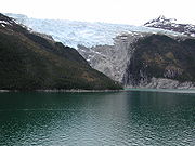
Subantarctic glaciers
This is a list of glacierGlacier
A glacier is a large persistent body of ice that forms where the accumulation of snow exceeds its ablation over many years, often centuries. At least 0.1 km² in area and 50 m thick, but often much larger, a glacier slowly deforms and flows due to stresses induced by its weight...
s in the subantarctic. This list includes one snow field
Snow field
A snow field, snowfield or neve is a permanent accumulation of snow and ice, typically found below the snow line. Normally the term is applied to mountainous and glacial terrain. In glaciology, the term refers to areas of permanent snow cover....
(Murray Snowfield
Murray Snowfield
Murray Snowfield is a snowfield centered 2 nautical miles south of Possession Bay in South Georgia. The name "John Murray-Gletscher" was given to a glacier flowing into the head of Possession Bay by members of the Second German Antarctic Expedition, 1911-12...
). Snow fields are not glaciers in the strict sense of the word, but they are commonly found at the accumulation zone
Accumulation zone
On a glacier, the accumulation zone is the area above the firn line, where snowfall accumulates and exceeds the losses from ablation, . The annual Glacier equilibrium line separates the accumulation and ablation zone annually...
or head of a glacier. For the purposes of this list, Antarctica is defined as any latitude further south than 60º (the continental limit according to the Antarctic Treaty).
| Name of Glacier | Coordinates Geodetic system Geodetic systems or geodetic data are used in geodesy, navigation, surveying by cartographers and satellite navigation systems to translate positions indicated on their products to their real position on earth.... |
Length or (Width) | Location |
|---|---|---|---|
| Abbotsmith Glacier Abbotsmith Glacier Abbotsmith Glacier is a well-defined glacier, long, descending from the ice-covered west slopes of Big Ben to the west side of Heard Island in the southern Indian Ocean. The glacier lies between Walsh and Henderson Bluffs... |
53°6′S 73°24′E | 4.8 km | Heard Island Heard Island and McDonald Islands The Heard Island and McDonald Islands are an Australian external territory and volcanic group of barren Antarctic islands, about two-thirds of the way from Madagascar to Antarctica. The group's overall size is in area and it has of coastline... |
| Allison Glacier | 53°04′S 73°24′E | Heard Island Heard Island and McDonald Islands The Heard Island and McDonald Islands are an Australian external territory and volcanic group of barren Antarctic islands, about two-thirds of the way from Madagascar to Antarctica. The group's overall size is in area and it has of coastline... |
|
| Austin Glacier Austin Glacier Austin Glacier is a glacier flowing north to Beckmann Fjord, Bay of Isles, on the north coast of South Georgia. The name appears to be first used on a 1931 British Admiralty chart.... |
54°4′S 37°12′W | South Georgia Group South Georgia and the South Sandwich Islands South Georgia and the South Sandwich Islands is a British overseas territory and overseas territory of the European Union in the southern Atlantic Ocean. It is a remote and inhospitable collection of islands, consisting of South Georgia and a chain of smaller islands, known as the South Sandwich... |
|
| Bary Glacier Bary Glacier Bary Glacier is a glacier flowing west into Jacobsen Bight, South Georgia, south of Christophersen Glacier. The glacier cuts through the longest sedimentary sequence on the island, from Christophersen Glacier to Cape Darnley. It was named by the UK Antarctic Place-Names Committee in 1982 after... |
54°26′S 36°47′W | South Georgia Group | |
| Baudissin Glacier Baudissin Glacier Baudissin Glacier is a tidewater glacier on the north side of Heard Island. in the southern Indian Ocean. Located 1 nautical mile west of Challenger Glacier, Baudissin Glacier is 1.5 nautical miles wide and flows into the western part of Corinthian Bay. The terminus of Baudissin Glacier is... |
53°2′S 73°26′E | (2.8 km) | Heard Island |
| Bertrab Glacier Bertrab Glacier Bertrab Glacier is a small glacier at the head of Gold Harbour, at the east end of South Georgia. It was charted by the Second German Antarctic Expedition, 1911–12, under Wilhelm Filchner, and named by him for General von Bertrab, Chief Quartermaster in the German General Staff and Chief of the... |
54°37′S 35°57′W | "small" | South Georgia Group |
| Bogen Glacier Bogen Glacier Bogen Glacier is a small glacier on the north side of Drygalski Fjord between Trendall Crag and Hamilton Bay, at the southeast end of South Georgia. It was named by the UK Antarctic Place-Names Committee in 1979 after Arne Bogen, Norwegian sealer working in South Georgia after 1950; Master of the... |
54°48′S 35°56′W | "small" | South Georgia Group |
| Briggs Glacier Briggs Glacier Briggs Glacier is a glacier between Mount Worsley and The Trident in central South Georgia, flowing northwest into Murray Snowfield. It was charted as a glacier flowing into the head of Possession Bay in 1929 by Lieutenant Commander John M. Chaplin, Royal Navy... |
54°1′S 37°8′W | South Georgia Group | |
| Brøgger Glacier Brøgger Glacier Brøgger Glacier is a glacier long, flowing west into the southern part of Undine South Harbour on the south coast of South Georgia. The name appears on a chart by Professor Olaf Holtedahl, Norwegian geologist who investigated South Georgia in 1928, and is probably for Professor Waldemar Brøgger,... |
54°32′S 36°26′W | 13 km | South Georgia Group |
| Brown Glacier Brown Glacier Brown Glacier is a glacier just south of Round Hill on the east side of Heard Island in the southern Indian Ocean. Its terminus is at Brown Lagoon. To the northwest of Brown Glacier is Compton Glacier, whose terminus is located at Compton Lagoon, between Gilchrist Beach and Fairchild Beach... |
53°4′S 73°39′E | Heard Island | |
| Brunonia Glacier Brunonia Glacier Brunonia Glacier is a glacier which flows east to the head of Sunset Fjord in the Bay of Isles, South Georgia. It was charted in 1912–13 by American ornithologist and naturalist Robert Cushman Murphy, who visited South Georgia aboard the sealing brig Daisy of New Bedford, Massachusetts under... |
54°3′S 37°29′W | South Georgia Group | |
| Buxton Glacier Buxton Glacier Buxton Glacier is a glacier flowing northeast between Heaney Glacier and Cook Glacier, on the north coast of the island of South Georgia, immediately south of Mount Skittle. The terminus of Buxton Glacier is located at Saint Andrews Bay... |
54°26′S 36°12′W | South Georgia Group | |
| Challenger Glacier Challenger Glacier Challenger Glacier is a tidewater glacier on the north side of Heard Island in the southern Indian Ocean. Located east of Baudissin Glacier, Challenger Glacier is wide and flows into the eastern side of Corinthian Bay, close west to Saddle Point. To the east of Challenger Glacier is Downes... |
53°2′S 73°28′E | Heard Island | |
| Christensen Glacier Christensen Glacier (South Georgia) Christensen Glacier is a glacier long, flowing south into the eastern part of Newark Bay on the south coast of South Georgia. It was surveyed by the South Georgia Survey in the period 1951–57, and named by the UK Antarctic Place-Names Committee for Chr. Fred. Christensen, Norwegian naval architect... |
54°2′S 36°52′W | South Georgia Group | |
| Christensen Glacier Christensen Glacier (Bouvet Island) Christensen Glacier is a glacier which flows to the south coast of Bouvet Island , east of Cato Point. It was first charted in 1898 by a German expedition under Karl Chun, and recharted in December 1927 by a Norwegian expedition under Captain Harald Horntvedt. It was named by Horntvedt after Lars... |
54°28′S 3°24′E | Bouvet Island Bouvet Island Bouvet Island is an uninhabited Antarctic volcanic island in the South Atlantic Ocean, 2,525 km south-southwest of South Africa. It is a dependent territory of Norway and, lying north of 60°S latitude, is not subject to the Antarctic Treaty. The centre of the island is an ice-filled crater of an... |
|
| Christophersen Glacier Christophersen Glacier Christophersen Glacier is a glacier long, flowing west into Jacobsen Bight on the south coast of South Georgia. It was surveyed by the South Georgia Survey in the period 1951–57, and named by the UK Antarctic Place-Names Committee for Pedro Christophersen, one of the first Directors of the... |
54°25′S 36°47′W | South Georgia Group | |
| Clayton Glacier Clayton Glacier Clayton Glacier is a small glacier flowing north along Murphy Wall into Sunset Fjord, Bay of Isles, South Georgia. It was named by the UK Antarctic Place-Names Committee for Roger A.S. Clayton, British Antarctic Survey geologist who worked in the area, 1972–74.... |
54°4′S 37°26′W | South Georgia Group | |
| Compton Glacier Compton Glacier Compton Glacier is a glacier, long, flowing northeast from the lower slopes of the Big Ben massif to the northeast side of Heard Island in the southern Indian Ocean. Its terminus is located at Compton Lagoon, between Gilchrist Beach and Fairchild Beach. To the northwest of Compton Glacier is Ealey... |
53°3′S 73°37′E | Heard Island | |
| Cook Glacier Cook Glacier, South Georgia Cook Glacier is a glacier which flows in a north-northeasterly direction to Saint Andrews Bay on the north coast of South Georgia. It was named by the German group of the International Polar Year Investigations based at nearby Moltke Harbour in 1882–83, for Captain James Cook.... |
54°27′S 36°11′W | South Georgia Group | |
| Crean Glacier Crean Glacier Crean Glacier is a glacier 4 miles long, flowing northwest from Wilckens Peaks to the head of Antarctic Bay on the north coast of South Georgia. Surveyed by the SGS in the period 1951-57 and named by the United Kingdom Antarctic Place-Names Committee for Irishman Tom Crean, Second Officer of the... |
54°8′S 37°1′W | 6 km | South Georgia Group |
| Deacock Glacier Deacock Glacier Deacock Glacier is a glacier close west of Lavett Bluff on the south side of Heard Island in the southern Indian Ocean. Its terminus is between Cape Labuan and Long Beach. To the east of Deacock Glacier is Fiftyone Glacier, whose terminus is located between Lavett Bluff and Lambeth Bluff... |
53°11′S 73°31′E | Heard Island | |
| Dead End Glacier Dead End Glacier Dead End Glacier is a glacier flowing east from the south end of the Salvesen Range of South Georgia into the west side of Salomon Glacier. Surveyed by the SGS in the period 1951-57, and so named by the United Kingdom Antarctic Place-Names Committee because there is no route for sledging parties... |
54°47′S 35°56′W | South Georgia Group | |
| Downes Glacier Downes Glacier Downes Glacier is a broad tidewater glacier on the north side of Heard Island in the southern Indian Ocean. It flows north on both sides of Cape Bidlingmaier to the north coast of Heard Island. To the east of Downes Glacier is Ealey Glacier, whose terminus is located close southeast of Cape... |
53°2′S 73°31′E | Heard Island | |
| Ealey Glacier Ealey Glacier Ealey Glacier is a glacier, flowing northeast from the lower slopes of the Big Ben massif to the northeast side of Heard Island in the southern Indian Ocean. Its terminus is located close southeast of Cape Bidlingmaier, between Melbourne Bluff and North Barrier. The glacier terminates in ice cliffs... |
53°2′S 73°35′E | Heard Island | |
| Eclipse Glacier Eclipse Glacier Eclipse Glacier is a glacier flowing southwest into the north part of Jacobsen Bight on the south coast of South Georgia. So named by the British South Georgia Survey, 1954-55, led by George A. Sutton.... |
54°23′S 36°5′W | South Georgia Group | |
| Esmark Glacier Esmark Glacier Esmark Glacier is a glacier flowing into the west part of Jossac Bight on the south coast of South Georgia. Named by the Norwegian expedition under Holtedahl, 1927-28, probably for Jens Esmark, professor of mineralogy at the University of Kristiania , Norway.... |
54°13′S 37°13′W | South Georgia Group | |
| Fiftyone Glacier Fiftyone Glacier Fiftyone Glacier is a large glacier flowing southwards, on the south side of Heard Island in the southern Indian Ocean. Its terminus is located between Lavett Bluff and Lambeth Bluff. To the northeast of Fiftyone Glacier is Winston Glacier, whose terminus is located at Winston Lagoon, between Cape... |
53°11′S 73°34′E | Heard Island | |
| Fortuna Glacier Fortuna Glacier Fortuna Glacier is a tidewater glacier at the mouth of Cumberland Bay on the island of South Georgia. It flows in a northeast direction to its terminus just west of Cape Best, with an eastern distributary almost reaching the west side of Fortuna Bay, on the north coast of South Georgia. Named in... |
54°6′S 36°51′W | South Georgia Group | |
| Geikie Glacier Geikie Glacier Geikie Glacier is a glacier which flows northeast to Mercer Bay, at the southwest end of Cumberland West Bay, South Georgia. First charted by the Swedish Antarctic Expedition, 1901–04, under Nordenskjold, who named it after Sir Archibald Geikie , noted Scottish geologist and Director-General of... |
54°17′S 36°41′W | South Georgia Group | |
| Gotley Glacier Gotley Glacier Gotley Glacier is a well-defined glacier, 5 nautical miles long, descending from the ice-covered slopes of the Big Ben massif to the southwest side of Heard Island in the southern Indian Ocean. Its terminus is located between Cape Arkona and Cape Labuan. To the east of Gotley Glacier is Deacock... |
53°10′S 73°27′E | 13.2 km | Heard Island |
| Graae Glacier Graae Glacier Graae Glacier is a glacier 2 miles long on the north side of Mount Sabatier, flowing west-southwest to Trollhul in the south part of South Georgia. Surveyed by the SGS in the period 1951-57, and named by the United Kingdom Antarctic Place-Names Committee for Morgens E.W. Graae of Denmark, who... |
54°48′S 36°1′W | 3.2 km | South Georgia Group |
| Grace Glacier Grace Glacier Grace Glacier is a glacier which flows north into Ample Bay at the Bay of Isles, South Georgia, near Salisbury Plain. Charted in 1912-13 by Robert Cushman Murphy, American naturalist aboard the brig Daisy, who named it for his wife, Grace Barstow Murphy.... |
54°4′S 37°23′W | South Georgia Group | |
| Hamberg Glacier Hamberg Glacier Hamberg Glacier is a glacier which flows in an east-northeast direction from the northeast side of Mount Sugartop to the west side of the head of Moraine Fjord, South Georgia. Charted by the Swedish Antarctic Expedition, 1901-04, under Nordenskjold, who named it for Axel Hamberg, Swedish... |
54°21′S 36°31′W | South Georgia Group | |
| Harker Glacier Harker Glacier Harker Glacier is a tidewater glacier on South Georgia Island in the southern Atlantic Ocean. Harker glacier was first mapped by the Swedish Antarctic Expedition , and named De Geer Glacier, after Gerard De Geer , a Swedish geologist who specialized in geomorphology and geochronology... |
54°22′S 36°32′W | South Georgia Group | |
| Harmer Glacier Harmer Glacier Harmer Glacier is a glacier 3 nautical miles long, flowing southwest from Starbuck Peak to the sea close north of Ranvik, on the south coast of South Georgia. Surveyed by the SGS in the period 1951-57, and named by the United Kingdom Antarctic Place-Names Committee for Sir Sidney F. Harmer.... |
54°46′S 36°15′W | South Georgia Group | |
| Heaney Glacier Heaney Glacier Heaney Glacier is a glacier, 4 nautical miles long, which lies close northwest of Cook Glacier and flows northeast and then east toward Saint Andrews Bay on the north coast of South Georgia. Surveyed by the South Georgia Survey, 1951-52, and named by the United Kingdom Antarctic Place-Names... |
54°25′S 36°12′W | South Georgia Group | |
| Helland Glacier Helland Glacier Helland Glacier is a glacier 4 nautical miles long flowing southwest from Mount Paget to Rocky Bay, on the south side of South Georgia. Mapped by Olaf Holtedahl during his visit to South Georgia in 1927-28, and named by him for Amund Helland , Norwegian mining geologist and glaciologist.... |
54°29′S 36°37′W | South Georgia Group | |
| Henningsen Glacier Henningsen Glacier Henningsen Glacier is a glacier 3 nautical miles long, flowing southwest to the south coast of South Georgia between Cape Darnley and Rocky Bay. Surveyed by the South Georgia Survey expedition led by Duncan Carse. Named by the United Kingdom Antarctic Place-Names Committee for Leonard... |
54°27′S 36°42′W | South Georgia Group | |
| Herz Glacier Herz Glacier Herz Glacier is a glacier flowing southeast from the vicinity of Mount Paterson to the east coast of South Georgia. Named by the German Antarctic Expedition under Wilhelm Filchner, 1911-12.... |
54°41′S 35°58′W | South Georgia Group | |
| Hindle Glacier Hindle Glacier Hindle Glacier is a glacier 6 miles long, flowing north from the vicinity of Mount Paterson into Royal Bay on the north coast of South Georgia.-History:... |
54°34′S 36°5′W | 10 km | South Georgia Group |
| Hodges Glacier Hodges Glacier Hodges Glacier is a small glacier 1 nautical mile west of Grytviken, South Georgia, flowing from the south side of Petrel Peak to the foot of Mount Hodges. The name was recommended by the United Kingdom Antarctic Place-Names Committee and derives from association with Mount Hodges.... |
54°16′S 36°32′W | South Georgia Group | |
| Horntvedt Glacier Horntvedt Glacier Horntvedt Glacier is a small glacier flowing to the north coast of Bouvetøya, immediately east of Cape Circoncision. First charted in 1898 by a German expedition under Karl Chun. Recharted in December 1927 by a Norwegian expedition which named it for Harald Horntvedt, captain of the expedition... |
54°25′S 3°21′E | Bouvet Island | |
| Jacka Glacier Jacka Glacier Jacka Glacier is a long glacier which flows northeast from Hayter Peak and terminates in icefalls opposite Vanhoffen Bluff on the north side of Heard Island in the southern Indian Ocean. The glacier appears to be roughly charted on an 1860 sketch map compiled by Captain H.C. Chester, an American... |
53°00′S 73°20′E | 1.3 km | Heard Island |
| Jenkins Glacier Jenkins Glacier Jenkins Glacier is a glacier close south of Risting Glacier, flowing east into the head of Drygalski Fjord in the southeast part of South Georgia. The glacier was named for Erich von Drygalski by the German Antarctic Expedition, 1911–12, under Wilhelm Filchner... |
54°46′S 36°7′W | South Georgia Group | |
| Jewell Glacier Jewell Glacier Jewell Glacier is a short glacier flowing south-southwest from Mount Grant into Jossac Bight on the south coast of South Georgia. Named by the United Kingdom Antarctic Place-Names Committee in 1982 after John A. Jewell, British Antarctic Survey field assistant in this area, 1976-77, Rothera... |
54°16′S 37°8′W | South Georgia Group | |
| Keilhau Glacier Keilhau Glacier Keilhau Glacier is a glacier 5 miles long flowing west from Kohl Plateau and then southwest to Jossac Bight, on the south coast of South Georgia. Mapped by Olaf Holtedahl during his visit to South Georgia in 1927-28, and named by him for Baltazar M. Keilhau , Norwegian geologist and professor of... |
54°16′S 37°4′W | 8 km | South Georgia Group |
| Kjerulf Glacier Kjerulf Glacier Kjerulf Glacier is a glacier 7 nautical miles long flowing west from Mount Sugartop to the east side of Newark Bay, on the south coast of South Georgia. Mapped by Olaf Holtedahl during his visit to South Georgia in 1927-28, and named by him for Theodor Kjerulf , Norwegian geologist and Professor... |
54°21′S 36°51′W | South Georgia Group | |
| König Glacier König Glacier König Glacier is a glacier, 3 nautical miles long and 1.5 nautical miles wide, flowing in a northerly direction from the north side of Neumayer Glacier to the head of Fortuna Bay, South Georgia... |
54°1′S 36°48′W | South Georgia Group | |
| Lancing Glacier Lancing Glacier Lancing Glacier is a glacier 3 nautical miles long, flowing south from Mount Corneliussen and Smillie Peak to Newark Bay on the south side of South Georgia. Surveyed by the SGS in the period 1951-57, and named by the United Kingdom Antarctic Place-Names Committee for the Lancing , built in 1898,... |
54°2′S 36°56′W | South Georgia Group | |
| Lewald Glacier Lewald Glacier Lewald Glacier is a small glacier 3 nautical miles west of Cape Vahsel, flowing northward to the coast at the east end of South Georgia. Named by the German Antarctic Expedition under Wilhelm Filchner, 1911-12, for Theodor Lewald, Ministerialdirektor im Reichsamt des Innern, Germany, who took an... |
54°45′S 35°52′W | South Georgia Group | |
| Lied Glacier Lied Glacier Lied Glacier is a glacier close north of Cape Arkona on the southwest side of Heard Island in the southern Indian Ocean. To the southeast of Lied Glacier is Gotley Glacier, whose terminus is located between Cape Arkona and Cape Labuan. Cape Arkona separates Lied Glacier from Gotley Glacier... |
53°9′S 73°26′E | Heard Island | |
| Lucas Glacier Lucas Glacier Lucas Glacier is a glacier flowing north into the Bay of Isles, South Georgia, close west of Luck Point. Charted in 1912-13 by Robert Cushman Murphy, American naturalist aboard the brig Daisy, who named it for Frederic Augustus Lucas, Director of the American Museum of Natural History at that time.... |
54°4′S 37°18′W | South Georgia Group | |
| Lyell Glacier Lyell Glacier, South Georgia For the glacier located on Mount Lyell in California, see Lyell GlacierLyell Glacier is a glacier flowing in a north direction to Harpon Bay at the southeast head of Cumberland West Bay, South Georgia... |
54°17′S 36°37′W | South Georgia Group | |
| Mary Powell Glacier | Heard Island | ||
| Morris Glacier Morris Glacier Morris Glacier is a glacier flowing north to the head of Sea Leopard Fjord in the Bay of Isles, South Georgia. Charted in 1912-13 by Robert Cushman Murphy, American naturalist aboard the brig Daisy, who named it for Edward Lyman Morris, a botanist who was then head of the Deptartment of Natural... |
54°5′S 37°14′W | South Georgia Group | |
| Murray Snowfield Murray Snowfield Murray Snowfield is a snowfield centered 2 nautical miles south of Possession Bay in South Georgia. The name "John Murray-Gletscher" was given to a glacier flowing into the head of Possession Bay by members of the Second German Antarctic Expedition, 1911-12... |
54°9′S 37°9′W | South Georgia Group | |
| Nachtigal Glacier Nachtigal Glacier Nachtigal Glacier is a glacier 2 nautical miles long flowing north from Mount Fagan toward Doris Bay, South Georgia. Charted by the German group of the International Polar Year Investigations, 1882-83, who named the glacier after Dr. Gustav Nachtigal , German physician and explorer of Africa.... |
54°29′S 36°9′W | South Georgia Group | |
| Neumayer Glacier Neumayer Glacier Neumayer Glacier is a glacier, 8 nautical miles long and 2 nautical miles wide, which flows east along the north flank of the Allardyce Range to the west side of the head of Cumberland West Bay, South Georgia... |
54°15′S 36°41′W | 13 km | South Georgia Group |
| Nordenskjöld Glacier Nordenskjold Glacier Nordenskjold Glacier is a large glacier flowing north to the head of Cumberland East Bay, on the north coast of South Georgia. It was charted by the Swedish Antarctic Expedition and named for Otto Nordenskiöld, leader of the expedition.-External links:*... |
54°22′S 36°22′W | "large" | South Georgia Group |
| Novosilski Glacier Novosilski Glacier Novosilski Glacier is a glacier, 8 miles long and 2 miles wide, flowing in a westerly direction from the southwest slopes of the Salvesen Range to Novosilski Bay on the south coast of South Georgia. First surveyed and named by a German expedition 1928-29, under Kohl-Larsen. The name derives from... |
54°4′S 36°18′W | 13 km | South Georgia Group |
| Paget Glacier Paget Glacier Paget Glacier is a glacier in South Georgia, 4 miles long and 1 mile wide, which flows northeast from the north slopes of Mount Paget into the west side of Nordenskjold Glacier. Roughly surveyed in 1928-29 by a German expedition under Kohl-Larsen, and resurveyed in 1951-52 by the SGS. The name,... |
54°24′S 36°28′W | 6 km | South Georgia Group |
| Peters Glacier Peters Glacier Peters Glacier is a glacier flowing southward into the west side of Cheapman Bay, South Georgia. Named by United Kingdom Antarctic Place-Names Committee for Nikolaus Peters, a leading German authority on whales and whaling and Director of Reichstelle fur Walforschung, Hamburg, 1937-1940.... |
54°8′S 37°33′W | South Georgia Group | |
| Philippi Glacier | 54°49′S 36°3′W | South Georgia Group | |
| Posadowsky Glacier Posadowsky Glacier (Bouvet Island) Posadowsky Glacier is a glacier which flows to the north coast of Bouvetøya, 1 nautical mile eastward of Cape Circoncision. It was first charted and named by the Gauss Expedition under Erich von Drygalski, which visited the island in February 1902.... |
54°25′S 32°2′E | Bouvet Island | |
| Price Glacier Price Glacier Price Glacier is a glacier 3.5 miles long, flowing southwest to Cheapman Bay on the south side of South Georgia. Surveyed by the SGS in the period 1951-57, and named for Thomas Price, member of the SGS, 1955-56.... |
54°7′S 37°29′W | South Georgia Group | |
| Purvis Glacier Purvis Glacier Purvis Glacier is a glacier flowing generally northeast into the west side of Possession Bay, on the north coast of South Georgia. Charted by the German Antarctic Expedition under Wilhelm Filchner, 1911–12, and named after John Murray-Gletscher. It was renamed Purvis Glacier, possibly to avoid... |
54°6′S 37°1′W | South Georgia Group | |
| Quensel Glacier Quensel Glacier Quensel Glacier is a small glacier flowing southeast into Cooper Bay at the east tip of South Georgia. It was named by the United Kingdom Antarctic Place-Names Committee after Percy D. Quensel, Swedish geologist of Uppsala University, who visited South Georgia with Carl Skottsberg in 1909.... |
54°46′S 35°5′W | "small" | South Georgia Group |
| Risting Glacier Risting Glacier Risting Glacier is a glacier, 4.5 nautical miles long, lying north of Jenkins Glacier and flowing southeast into the head of Drygalski Fjord in the south part of South Georgia... |
54°46′S 36°6′W | South Georgia Group | |
| Ross Glacier Ross Glacier Not to be confused with Ross Ice Shelf in AntarcticaRoss Glacier is a glacier 6 miles long, flowing east from the juncture of Allardyce and Salvesen Ranges to Little Moltke Harbour, Royal Bay, on the north coast of South Georgia... |
54°33′S 36°6′W | 10 km | South Georgia Group |
| Ryan Glacier Ryan Glacier Ryan Glacier is a glacier, 2 nautical miles long, flowing west to the head of Ice Fjord, South Georgia. The German Antarctic Expedition named this glacier for Dr. Albrecht Penck, though an incorrect spelling "Penk" appeared on published maps. A number of significant Antarctic features, including... |
54°3′S 37°36′W | South Georgia Group | |
| Salomon Glacier Salomon Glacier Salomon Glacier is a glacier flowing south into Hamilton Bay, at the east end of South Georgia. Named by the German Antarctic Expedition under Wilhelm Filchner, 1911-12.... |
54°47′S 35°54′W | South Georgia Group | |
| Schmidt Glacier Schmidt Glacier Schmidt Glacier is a glacier, 0.7 nautical miles long, flowing west from Baudissin Glacier between Mount Drygalski and North West Cornice, on the west side of Heard Island in the southern Indian Ocean. To the north of Schmidt Glacier is Baudissin Glacier, whose terminus is located at the western... |
53°3′S 73°24′E | Heard Island | |
| Schrader Glacier Schrader Glacier Schrader Glacier is a small glacier which flows to the head of Wilson Harbour on the south coast of South Georgia. Charted by the German Antarctic Expedition under Wilhelm Filchner, 1911-12, and named for Dr. K. Schrader, leader of the German group of the International Polar Year Investigations... |
54°7′S 37°39′W | South Georgia Group | |
| Spenceley Glacier Spenceley Glacier Spenceley Glacier is a glacier 6 nautical miles long, flowing northwest along the southwest flank of Salvesen Range to Brøgger Glacier, in the south part of South Georgia. Surveyed by the South Georgia Survey under Duncan Carse in the period 1951-57, and named for George Spenceley, photographer... |
54°35′S 36°19′W | South Georgia Group | |
| Stephenson Glacier Stephenson Glacier Stephenson Glacier is a glacier close west of Dovers Moraine on the east side of Heard Island in the southern Indian Ocean. Its terminus is between Dovers Moraine and Stephenson Lagoon, with part of the glacier flowing to Doppler Hill and Sealers Beach. To the north of Stephenson Glacier is Brown... |
53°6′S 73°42′E | Heard Island | |
| Storey Glacier Storey Glacier Storey Glacier is a glacier on the northeast side of Drygalski Fjord at the southeast end of South Georgia. Named by the United Kingdom Antarctic Place-Names Committee after Bryan C. Storey, British Antarctic Survey geologist, 1974-79, who worked in the area, 1976-78.... |
54°47′S 36°1′W | South Georgia Group | |
| Twitcher Glacier Twitcher Glacier Twitcher Glacier is a glacier, 4 miles long, which flows east from the Salvesen Range to the east coast of South Georgia, immediately south of Herz Glacier and Iris Bay. The glacier was surveyed in 1951-52 by the SGS... |
54°43′S 35°56′W | 6 km | South Georgia Group |
| Tyrrell Glacier Tyrrell Glacier Tyrrell Glacier is a glacier flowing north into the head of Moraine Fjord where it joins Harker Glacier, on the north coast of South Georgia. Named by the United Kingdom Antarctic Place-Names Committee , 1982, in association with Harker Glacier, after George Walter Tyrrell , Senior Lecturer in... |
54°22′S 36°31′W | South Georgia Group | |
| Vahsel Glacier Vahsel Glacier Vahsel Glacier is a glacier on the northwestern side of Heard Island in the southern Indian Ocean. It flows west into South West Bay, between Erratic Point and Cape Gazert. Immediately to the north of Vahsel Glacier is Schmidt Glacier, whose terminus is located between Mount Drygalski and North... |
53°4′S 73°23′E | Heard Island | |
| Webb Glacier | 54°32′S 36°1′W | 3.2 km | South Georgia Group |
| Weddell Glacier Weddell Glacier Weddell Glacier is a glacier 2 nautical miles long on the north side of South Georgia, flowing north into Royal Bay between Will Point and Cape Charlotte. First mapped by the German group of the International Polar Year Investigations, 1882–83, and named for James Weddell, Master, Royal Navy, who... |
54°35′S 36°00′W | 3.2 km | South Georgia Group |
| Wheeler Glacier Wheeler Glacier Wheeler Glacier is a glacier draining the north flank of Mount Fraser, flowing west-northwest for 2 miles to the south coast of South Georgia. Surveyed by the SGS in the period 1951-57. Named by the United Kingdom Antarctic Place-Names Committee for J.F.G... |
54°36′S 36°22′W | 3.2 km | South Georgia Group |
| Winston Glacier Winston Glacier Winston Glacier is a glacier flowing to Winston Lagoon on the southeast side of Heard Island in the southern Indian Ocean. Its terminus is at Winston Lagoon, between Cape Lockyer and Oatt Rocks. To the northeast of Winston Glacier is Stephenson Glacier, whose terminus is located between Dovers... |
53°9′S 73°38′E | Heard Island |
Impact of climate change on SAMW
Climate change
Climate change is a significant and lasting change in the statistical distribution of weather patterns over periods ranging from decades to millions of years. It may be a change in average weather conditions or the distribution of events around that average...
, the SAMW will have less capacity to store dissolved carbon dioxide. Research using a computerized climate system model suggests that if atmospheric carbon dioxide concentration were to increase to 860 ppm by the year 2100 (roughly double today's concentration), the SAMW will decrease in density and salinity. The resulting reductions in the subduction and transport capacity of SAMW and AAIW water masses could potentially decrease the absorption and storage of CO2 in the Southern Ocean.
Flora and fauna
The landscape of Heard Island and nearby McDonald Island is constantly changing due to volcanismVolcanism
Volcanism is the phenomenon connected with volcanoes and volcanic activity. It includes all phenomena resulting from and causing magma within the crust or mantle of a planet to rise through the crust and form volcanic rocks on the surface....
, strong winds and waves, and climate change
Climate change
Climate change is a significant and lasting change in the statistical distribution of weather patterns over periods ranging from decades to millions of years. It may be a change in average weather conditions or the distribution of events around that average...
. Volcanic activity has been observed in this area since the mid 1980s, with fresh lava
Lava
Lava refers both to molten rock expelled by a volcano during an eruption and the resulting rock after solidification and cooling. This molten rock is formed in the interior of some planets, including Earth, and some of their satellites. When first erupted from a volcanic vent, lava is a liquid at...
flows on the southwest flanks of Heard Island. Satellite imagery
Satellite imagery
Satellite imagery consists of photographs of Earth or other planets made by means of artificial satellites.- History :The first images from space were taken on sub-orbital flights. The U.S-launched V-2 flight on October 24, 1946 took one image every 1.5 seconds...
shows that McDonald Island increased in size from about 1 to 2.5 square kilometers between 1994 and 2004, as a result of volcanic activity.
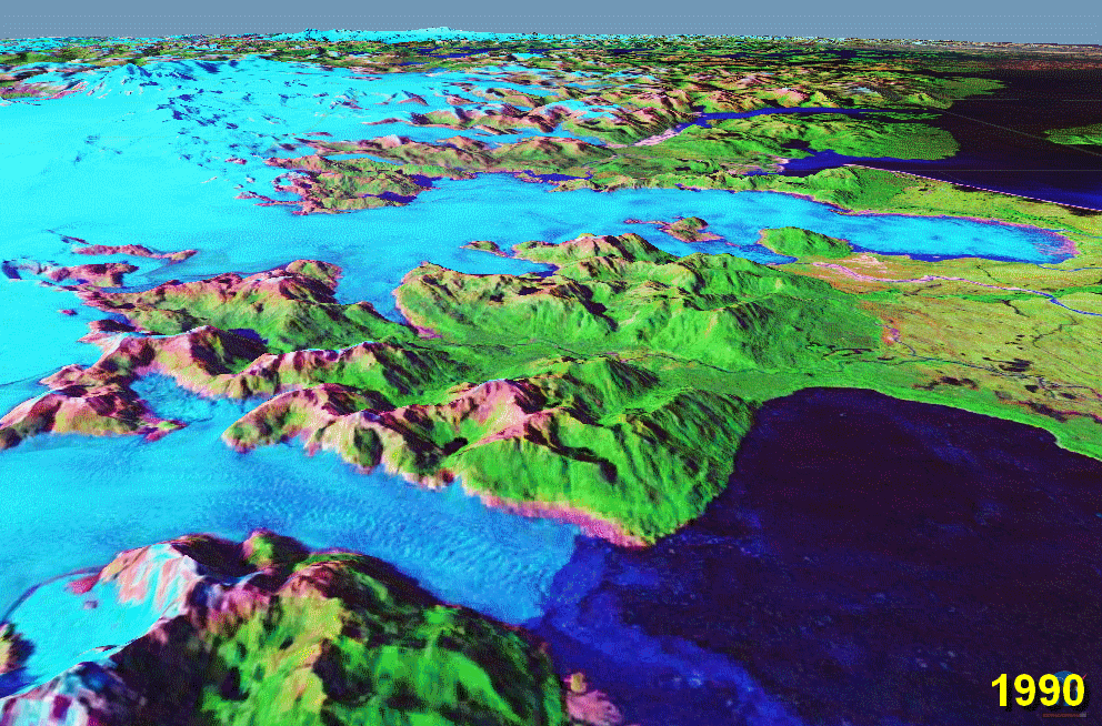
In addition to new land being produced by volcanism, warming of the climate is causing the retreat of glaciers
Retreat of glaciers since 1850
The retreat of glaciers since 1850 affects the availability of fresh water for irrigation and domestic use, mountain recreation, animals and plants that depend on glacier-melt, and in the longer term, the level of the oceans...
(see below section). These combined processes produce new ice-free terrestrial and freshwater ecoregions such as moraine
Moraine
A moraine is any glacially formed accumulation of unconsolidated glacial debris which can occur in currently glaciated and formerly glaciated regions, such as those areas acted upon by a past glacial maximum. This debris may have been plucked off a valley floor as a glacier advanced or it may have...
s and lagoon
Lagoon
A lagoon is a body of shallow sea water or brackish water separated from the sea by some form of barrier. The EU's habitat directive defines lagoons as "expanses of shallow coastal salt water, of varying salinity or water volume, wholly or partially separated from the sea by sand banks or shingle,...
s, which are now available for colonization by plants and animals. Heard Island has vast colonies of penguin
Penguin
Penguins are a group of aquatic, flightless birds living almost exclusively in the southern hemisphere, especially in Antarctica. Highly adapted for life in the water, penguins have countershaded dark and white plumage, and their wings have become flippers...
s and petrel
Petrel
Petrels are tube-nosed seabirds in the bird order Procellariiformes. The common name does not indicate relationship beyond that point, as "petrels" occur in three of the four families within that group...
s, and large harems of land-based marine predators such as elephant seal
Elephant seal
Elephant seals are large, oceangoing seals in the genus Mirounga. There are two species: the northern elephant seal and the southern elephant seal . Both were hunted to the brink of extinction by the end of the 19th century, but numbers have since recovered...
s and fur seal
Fur seal
Fur seals are any of nine species of pinnipeds in the Otariidae family. One species, the northern fur seal inhabits the North Pacific, while seven species in the Arctocephalus genus are found primarily in the Southern hemisphere...
s. Due to the very high numbers of seabird
Seabird
Seabirds are birds that have adapted to life within the marine environment. While seabirds vary greatly in lifestyle, behaviour and physiology, they often exhibit striking convergent evolution, as the same environmental problems and feeding niches have resulted in similar adaptations...
s and marine mammal
Marine mammal
Marine mammals, which include seals, whales, dolphins, and walruses, form a diverse group of 128 species that rely on the ocean for their existence. They do not represent a distinct biological grouping, but rather are unified by their reliance on the marine environment for feeding. The level of...
s on Heard Island, the area is considered a "biological hot spot". The marine environment surrounding the islands features diverse and distinctive benthic habitats
Benthic zone
The benthic zone is the ecological region at the lowest level of a body of water such as an ocean or a lake, including the sediment surface and some sub-surface layers. Organisms living in this zone are called benthos. They generally live in close relationship with the substrate bottom; many such...
that support a range of species including coral
Coral
Corals are marine animals in class Anthozoa of phylum Cnidaria typically living in compact colonies of many identical individual "polyps". The group includes the important reef builders that inhabit tropical oceans and secrete calcium carbonate to form a hard skeleton.A coral "head" is a colony of...
s, sponges, barnacle
Barnacle
A barnacle is a type of arthropod belonging to infraclass Cirripedia in the subphylum Crustacea, and is hence related to crabs and lobsters. Barnacles are exclusively marine, and tend to live in shallow and tidal waters, typically in erosive settings. They are sessile suspension feeders, and have...
s and echinoderm
Echinoderm
Echinoderms are a phylum of marine animals. Echinoderms are found at every ocean depth, from the intertidal zone to the abyssal zone....
s. This marine environment also serves as a nursery area for a range of fishes, including some species of commercial interest.
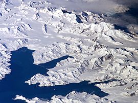
Retreat of subantarctic glaciers
Retreat of glaciers since 1850
The retreat of glaciers since 1850 affects the availability of fresh water for irrigation and domestic use, mountain recreation, animals and plants that depend on glacier-melt, and in the longer term, the level of the oceans...
at significant rates throughout the southern hemisphere. With respect to glaciers of the Andes mountains in South America
South America
South America is a continent situated in the Western Hemisphere, mostly in the Southern Hemisphere, with a relatively small portion in the Northern Hemisphere. The continent is also considered a subcontinent of the Americas. It is bordered on the west by the Pacific Ocean and on the north and east...
, abundant evidence has been collected from ongoing research at Nevado del Ruiz
Nevado del Ruiz
The Nevado del Ruiz, also known as La Mesa de Herveo or Kumanday in the language of the local pre-Columbian indigenous people, is a volcano located on the border of the departments of Caldas and Tolima in Colombia, about west of the capital city Bogotá. It is a stratovolcano, composed of many...
in Colombia
Colombia
Colombia, officially the Republic of Colombia , is a unitary constitutional republic comprising thirty-two departments. The country is located in northwestern South America, bordered to the east by Venezuela and Brazil; to the south by Ecuador and Peru; to the north by the Caribbean Sea; to the...
, Quelccaya Ice Cap
Quelccaya Ice Cap
The Quelccaya Ice Cap is the largest glaciated area in the tropics. Located in the Cordillera Oriental section of the Andes mountains of Peru, the ice cap is at an average altitude of 5,470 meters and spans an area of 44 square kilometers...
and Qori Kalis Glacier in Peru
Peru
Peru , officially the Republic of Peru , is a country in western South America. It is bordered on the north by Ecuador and Colombia, on the east by Brazil, on the southeast by Bolivia, on the south by Chile, and on the west by the Pacific Ocean....
, Zongo, Chacaltaya
Chacaltaya
Chacaltaya is a mountain in the Cordillera Real, one of the mountain ranges of the Cordillera Oriental, itself a range of the Bolivian Andes. Its elevation is . Chacaltaya's glacier - which was as old as 18,000 years – had in 1940 an area of , reduced to in 2007 and was completely gone by 2009....
and Charquini glaciers in Bolivia
Bolivia
Bolivia officially known as Plurinational State of Bolivia , is a landlocked country in central South America. It is the poorest country in South America...
, the Aconcagua River
Aconcagua River
For other uses, see Aconcagua .The Aconcagua River is a river in Chile that rises from the joint of two minor tributary rivers at above sea level in the Andes, Juncal river from the east and Blanco river from the south east...
Basin in the central Chilean Andes, and the Northern Patagonian
Northern Patagonian Ice Field
The Northern Patagonian Ice Field, located in southern Chile, is the smaller of two remnant parts in which the Patagonian Ice Sheet in the Andes Mountains of lower South America can be divided. It is completely contained within the boundaries of Laguna San Rafael National Park...
and Southern Patagonian
Southern Patagonian Ice Field
The Southern Patagonian Ice Field , located at the Southern Patagonic Andes between Argentina and Chile, is the second largest contiguous extrapolar extent of ice in the world...
ice field
Ice field
An ice field is an area less than 50,000 km² of ice often found in the colder climates and higher altitudes of the world where there is sufficient precipitation. It is an extensive area of interconnected valley glaciers from which the higher peaks rise as nunataks...
s. Retreat of glaciers in New Zealand
New Zealand
New Zealand is an island country in the south-western Pacific Ocean comprising two main landmasses and numerous smaller islands. The country is situated some east of Australia across the Tasman Sea, and roughly south of the Pacific island nations of New Caledonia, Fiji, and Tonga...
and Antarctica is also well documented.
Bearing this in mind, it should come as no surprise that many subantarctic glaciers are also in retreat. Mass balance
Glacier mass balance
Crucial to the survival of a glacier is its mass balance, the difference between accumulation and ablation . Climate change may cause variations in both temperature and snowfall, causing changes in mass balance. Changes in mass balance control a glacier's long term behavior and is the most...
is significantly negative on many glaciers on Kergeulen Island, Heard Island, South Georgia and Bouvet Island.
Glaciers of Heard Island
Heard Island is a heavily glacierized, subantarctic volcanic islandHigh island
In geology , a high island is an island of volcanic origin. The term can be used to distinguish such islands from low islands, whose origin is due to sedimentation or uplifting of coral reefs.-Definition and origin:...
located in the Southern Ocean
Southern Ocean
The Southern Ocean comprises the southernmost waters of the World Ocean, generally taken to be south of 60°S latitude and encircling Antarctica. It is usually regarded as the fourth-largest of the five principal oceanic divisions...
, roughly 4000 kilometers southwest of Australia
Australia
Australia , officially the Commonwealth of Australia, is a country in the Southern Hemisphere comprising the mainland of the Australian continent, the island of Tasmania, and numerous smaller islands in the Indian and Pacific Oceans. It is the world's sixth-largest country by total area...
. 80% of the island is covered in ice, with glaciers descending from 2400 meters to sea level
Sea level
Mean sea level is a measure of the average height of the ocean's surface ; used as a standard in reckoning land elevation...
. Due to the steep topography
Topography
Topography is the study of Earth's surface shape and features or those ofplanets, moons, and asteroids...
of Heard Island, most of its glaciers are relatively thin (averaging only about 55 meters in depth). The presence of glaciers on Heard Island provides an excellent opportunity to measure the rate of glacial retreat as an indicator of climate change.
Available records show no apparent change in glacier mass balance
Glacier mass balance
Crucial to the survival of a glacier is its mass balance, the difference between accumulation and ablation . Climate change may cause variations in both temperature and snowfall, causing changes in mass balance. Changes in mass balance control a glacier's long term behavior and is the most...
between 1874 and 1929. Between 1949 and 1954, marked changes were observed to have occurred in the ice formations above 5000 feet on the southwestern slopes of Big Ben
Big Ben (Heard Island)
Big Ben is a volcanic massif that dominates the geography of Heard Island in the southern Indian Ocean. It is a composite cone with a diameter of approximately 25 kilometres. Its highest peak is Mawson Peak, which is 2,745 m above sea level. Much of it is covered by ice, including 14...
, possibly as a result of volcanic activity
Volcanism
Volcanism is the phenomenon connected with volcanoes and volcanic activity. It includes all phenomena resulting from and causing magma within the crust or mantle of a planet to rise through the crust and form volcanic rocks on the surface....
. By 1963, major recession was obvious below 2000 feet on almost all glaciers, and minor recession was evident as high as 5000 feet.
Retreat of glacier fronts across Heard Island is evident when comparing aerial photograph
Aerial photography
Aerial photography is the taking of photographs of the ground from an elevated position. The term usually refers to images in which the camera is not supported by a ground-based structure. Cameras may be hand held or mounted, and photographs may be taken by a photographer, triggered remotely or...
s taken in December 1947 with those taken on a return visit in early 1980. Retreat of Heard Island glaciers is most dramatic on the eastern section of the island, where the termini
Glacier terminus
A glacier terminus, or snout, is the end of a glacier at any given point in time. Although glaciers seem motionless to the observer, in reality glaciers are in endless motion and the glacier terminus is always either advancing or retreating...
of former tidewater glaciers are now located inland. Glaciers on the northern and western coasts have narrowed significantly, while the area of glaciers and ice cap
Ice cap
An ice cap is an ice mass that covers less than 50 000 km² of land area . Masses of ice covering more than 50 000 km² are termed an ice sheet....
s on Laurens Peninsula
Laurens Peninsula
Laurens Peninsula is a rugged peninsula surmounted by several ice-covered peaks. It forms the northwestern part of Heard Island in the southern Indian Ocean. The name was applied by the ANARE following their survey in 1948...
have shrunk by 30% - 65%.
During the time period between 1947 and 1988, the total area of Heard Island's glaciers decreased by 11%, from 288 km² (roughly 79% of the total area of Heard Island) to only 257 km². A visit to the island in the spring of 2000 found that the Stephenson
Stephenson Glacier
Stephenson Glacier is a glacier close west of Dovers Moraine on the east side of Heard Island in the southern Indian Ocean. Its terminus is between Dovers Moraine and Stephenson Lagoon, with part of the glacier flowing to Doppler Hill and Sealers Beach. To the north of Stephenson Glacier is Brown...
, Brown
Brown Glacier
Brown Glacier is a glacier just south of Round Hill on the east side of Heard Island in the southern Indian Ocean. Its terminus is at Brown Lagoon. To the northwest of Brown Glacier is Compton Glacier, whose terminus is located at Compton Lagoon, between Gilchrist Beach and Fairchild Beach...
and Baudissin
Baudissin Glacier
Baudissin Glacier is a tidewater glacier on the north side of Heard Island. in the southern Indian Ocean. Located 1 nautical mile west of Challenger Glacier, Baudissin Glacier is 1.5 nautical miles wide and flows into the western part of Corinthian Bay. The terminus of Baudissin Glacier is...
glaciers, among others, had retreated even further. The terminus of Brown Glacier has retreated approximately 1.1 kilometres since 1950. The total ice covered area of Brown Glacier is estimated to have decreased by roughly 29% between 1947 and 2004. This degree of loss of glacier mass is consistent with the measured increase in temperature of +0.9 °C over that time span.
The coastal ice cliffs of Brown Glacier and Stephenson Glacier, which in 1954 were over 50 feet high, had disappeared by 1963 when the glaciers terminated as much as 100 yards inland. Baudissin Glacier on the north coast, and Vahsel Glacier
Vahsel Glacier
Vahsel Glacier is a glacier on the northwestern side of Heard Island in the southern Indian Ocean. It flows west into South West Bay, between Erratic Point and Cape Gazert. Immediately to the north of Vahsel Glacier is Schmidt Glacier, whose terminus is located between Mount Drygalski and North...
on the west coast have lost at least 100 and 200 vertical feet of ice, respectively. Winston Glacier
Winston Glacier
Winston Glacier is a glacier flowing to Winston Lagoon on the southeast side of Heard Island in the southern Indian Ocean. Its terminus is at Winston Lagoon, between Cape Lockyer and Oatt Rocks. To the northeast of Winston Glacier is Stephenson Glacier, whose terminus is located between Dovers...
, which retreated approximately one mile between 1947 and 1963, appears to be a very sensitive indicator of glacier change on the island. The young moraines flanking Winston Lagoon
Winston Lagoon
Winston Lagoon is a lagoon indenting the southeast coast of Heard Island in the southern Indian Ocean, about 1 nautical mile northeast of Cape Lockyer. The feature is roughly portrayed on an American sealer chart of the 1860 period...
show that Winston Glacier has lost at least 300 vertical feet of ice within a recent time period.
The glaciers of Laurens Peninsula, whose maximum elevation is only 500 m above sea level, are smaller and shorter than most of the other Heard Island glaciers, and therefore much more sensitive to temperature effects. Accordingly, their total area has decreased by over 30 percent. Jacka Glacier
Jacka Glacier
Jacka Glacier is a long glacier which flows northeast from Hayter Peak and terminates in icefalls opposite Vanhoffen Bluff on the north side of Heard Island in the southern Indian Ocean. The glacier appears to be roughly charted on an 1860 sketch map compiled by Captain H.C. Chester, an American...
on the east coast of Laurens Peninsula has also demonstrated marked recession since 1955. In the early 1950s, Jacka Glacier had receded only slightly from its position in the late 1920s, but by 1997 it had receded about 700 m back from the coastline.
Possible causes of glacier recession on Heard Island include:
- Volcanic activity
- Southward movement of the Antarctic Convergence: such a movement conceivably might cause glacier retreat through a rise in sea and air temperatures
- Climatic change
The Australian Antarctic Division
Australian Antarctic Division
The Australian Antarctic Division is an agency of the Department of Sustainability, Environment, Water, Population and Communities . The division undertakes science programs and research projects to contribute to an understanding of Antarctica and the Southern Ocean...
conducted an expedition to Heard Island during the austral summer of 2003-04. A small team of scientists spent two months on the island, conducting studies on avian
Bird
Birds are feathered, winged, bipedal, endothermic , egg-laying, vertebrate animals. Around 10,000 living species and 188 families makes them the most speciose class of tetrapod vertebrates. They inhabit ecosystems across the globe, from the Arctic to the Antarctic. Extant birds range in size from...
and terrestrial biology and glaciology. Glaciologists conducted further research on the Brown Glacier, in an effort to determine whether glacial retreat is rapid or punctuated. Using a portable echo sounder
Echo sounding
Echo sounding is the technique of using sound pulses directed from the surface or from a submarine vertically down to measure the distance to the bottom by means of sound waves. This information is then typically used for navigation purposes or in order to obtain depths for charting purposes...
, the team took measurements of the volume of the glacier. Monitoring of climatic conditions continued, with an emphasis on the impact of Foehn winds on glacier mass balance. Based on the findings of that expedition, the rate of loss of glacier ice on Heard Island appears to be accelerating. Between 2000 and 2003, repeat GPS
Global Positioning System
The Global Positioning System is a space-based global navigation satellite system that provides location and time information in all weather, anywhere on or near the Earth, where there is an unobstructed line of sight to four or more GPS satellites...
surface surveys
Surveying
See Also: Public Land Survey SystemSurveying or land surveying is the technique, profession, and science of accurately determining the terrestrial or three-dimensional position of points and the distances and angles between them...
revealed that the rate of loss of ice in both the ablation zone
Ablation zone
Ablation zone refers to the low altitude area of a glacier or ice sheet where there is a net loss in ice mass due to melting, sublimation, evaporation, or calving. The ablation zone is delineated by the equilibrium line altitude , or snow line, which separates the ablation zone and the high...
and the accumulation zone
Accumulation zone
On a glacier, the accumulation zone is the area above the firn line, where snowfall accumulates and exceeds the losses from ablation, . The annual Glacier equilibrium line separates the accumulation and ablation zone annually...
of Brown Glacier was more than double average rate measured from 1947 to 2003. The increase in the rate of ice loss suggests that the glaciers of Heard Island are reacting to ongoing climate change, rather than approaching dynamic equilibrium
Dynamic equilibrium
A dynamic equilibrium exists once a reversible reaction ceases to change its ratio of reactants/products, but substances move between the chemicals at an equal rate, meaning there is no net change. It is a particular example of a system in a steady state...
. The retreat of Heard Island's glaciers is expected to continue for the foreseeable future.
See also
- Extreme points of the AntarcticExtreme points of the AntarcticThis is a list of the extreme points of the Antarctic, the points of Antarctic and sub-Antarctic lands that are farther to the south than any other location classified by continent and country...
- List of glaciers
- Category: Flora of subantarctic islands