
Harker Glacier
Encyclopedia
Harker Glacier is a tidewater glacier
on South Georgia Island
in the southern Atlantic Ocean
. Harker glacier was first mapped by the Swedish Antarctic Expedition
(1901-1904), and named De Geer Glacier, after Gerard De Geer
(1858-1943), a Swedish
geologist
who specialized in geomorphology
and geochronology
. It was remapped in 1912 by David Ferguson
, and renamed for Alfred Harker
(1859-1939), an English
geologist who specialised in petrology
and petrography
.
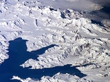
The valley in which Harker Glacier is located drains from south to north out of the Allardyce Range
into Moraine Fjord
in the eastern side of Cumberland Bay
, south of Grytviken
, the principal settlement of the island. Harker Glacier is a tidewater glacier that contributes iceberg
s to the bay. The glacier has not changed significantly since the 1970s, but is further advanced than when it was photographed by Frank Hurley
in 1914.
Glacier
A glacier is a large persistent body of ice that forms where the accumulation of snow exceeds its ablation over many years, often centuries. At least 0.1 km² in area and 50 m thick, but often much larger, a glacier slowly deforms and flows due to stresses induced by its weight...
on South Georgia Island
South Georgia and the South Sandwich Islands
South Georgia and the South Sandwich Islands is a British overseas territory and overseas territory of the European Union in the southern Atlantic Ocean. It is a remote and inhospitable collection of islands, consisting of South Georgia and a chain of smaller islands, known as the South Sandwich...
in the southern Atlantic Ocean
Atlantic Ocean
The Atlantic Ocean is the second-largest of the world's oceanic divisions. With a total area of about , it covers approximately 20% of the Earth's surface and about 26% of its water surface area...
. Harker glacier was first mapped by the Swedish Antarctic Expedition
Swedish Antarctic Expedition
The Swedish Antarctic Expedition was led by Otto Nordenskjöld and Carl Anton Larsen.-Background:Otto Nordenskjöld, a Swedish geologist and geographer, organized and lead a scientific expedition of the Antarctic Peninsula...
(1901-1904), and named De Geer Glacier, after Gerard De Geer
Gerard De Geer
Baron Gerard Jacob De Geer was a Swedish geologist who made significant contributions to Quaternary geology, particularly geomorphology and geochronology. De Geer is best known for his discovery of varves.- Early life and family :...
(1858-1943), a Swedish
Sweden
Sweden , officially the Kingdom of Sweden , is a Nordic country on the Scandinavian Peninsula in Northern Europe. Sweden borders with Norway and Finland and is connected to Denmark by a bridge-tunnel across the Öresund....
geologist
Geologist
A geologist is a scientist who studies the solid and liquid matter that constitutes the Earth as well as the processes and history that has shaped it. Geologists usually engage in studying geology. Geologists, studying more of an applied science than a theoretical one, must approach Geology using...
who specialized in geomorphology
Geomorphology
Geomorphology is the scientific study of landforms and the processes that shape them...
and geochronology
Geochronology
Geochronology is the science of determining the age of rocks, fossils, and sediments, within a certain degree of uncertainty inherent to the method used. A variety of dating methods are used by geologists to achieve this, and schemes of classification and terminology have been proposed...
. It was remapped in 1912 by David Ferguson
David Ferguson
David Ferguson is the name of:*David Ferguson, Dual Diagnosis Counsellor*David Ferguson *Dave Ferguson , British boxer*David Ferguson...
, and renamed for Alfred Harker
Alfred Harker (petrologist)
Alfred Harker FRS was an English geologist who specialised in petrology and interpretive petrography. He worked for the Geological Survey of Scotland and conducted extensive surveying and geological studies of western Scotland and the Isle of Skye...
(1859-1939), an English
England
England is a country that is part of the United Kingdom. It shares land borders with Scotland to the north and Wales to the west; the Irish Sea is to the north west, the Celtic Sea to the south west, with the North Sea to the east and the English Channel to the south separating it from continental...
geologist who specialised in petrology
Petrology
Petrology is the branch of geology that studies rocks, and the conditions in which rocks form....
and petrography
Petrography
Petrography is a branch of petrology that focuses on detailed descriptions of rocks. Someone who studies petrography is called a petrographer. The mineral content and the textural relationships within the rock are described in detail. Petrographic descriptions start with the field notes at the...
.
The valley in which Harker Glacier is located drains from south to north out of the Allardyce Range
Allardyce Range
The Allardyce Range is a mountain range rising south of Cumberland Bay and dominating the central part of South Georgia, a UK overseas territory. Mount Paget is the highest peak of the range and also the highest point in the UK territory...
into Moraine Fjord
Moraine Fjord
Moraine Fjord is an inlet 3.5 miles long with a reef extending across its entrance, forming the west head of Cumberland East Bay, South Georgia. Charted by the Swedish Antarctic Expedition under Nordenskjold, 1901-04, who so named it because of the large glacial moraine at its entrance....
in the eastern side of Cumberland Bay
Cumberland Bay
Cumberland Bay, wide at its entrance between Larsen and Barff Points, which separates into two extensive arms that recede inland along the northern coast of South Georgia. Discovered and named in 1775 by a British expedition under James Cook....
, south of Grytviken
Grytviken
Grytviken is the principal settlement in the British territory of South Georgia in the South Atlantic. It was so named in 1902 by the Swedish surveyor Johan Gunnar Andersson who found old English try pots used to render seal oil at the site. It is the best harbour on the island, consisting of a...
, the principal settlement of the island. Harker Glacier is a tidewater glacier that contributes iceberg
Iceberg
An iceberg is a large piece of ice from freshwater that has broken off from a snow-formed glacier or ice shelf and is floating in open water. It may subsequently become frozen into pack ice...
s to the bay. The glacier has not changed significantly since the 1970s, but is further advanced than when it was photographed by Frank Hurley
Frank Hurley
James Francis "Frank" Hurley, OBE was an Australian photographer and adventurer. He participated in a number of expeditions to Antarctica and served as an official photographer with Australian forces during both world wars.His artistic style produced many memorable images but he also used staged...
in 1914.
External links
- British Antarctic Service Metadata Management System Gazeteer entry for Harker Glacier.
- Photo of Harker Glacier, moraine visible.
- http://earthweb.ess.washington.edu/lnk/epic/Collections/Evans/pages/EP_0013_DAE_GL.htmPhoto of the calvingIce calvingIce calving, also known as glacier calving or iceberg calving, is a form of ice ablation or ice disruption. It is the sudden release and breaking away of a mass of ice from a glacier, iceberg, ice front, ice shelf, or crevasse...
terminus] of Harker Glacier.